‘Town Planning in British Malaya’ – Charles Reade’s Depiction of the Challenges facing Colonial Town Planning

The article entitled ‘Town Planning in British Malaya’ provides an insight into the unique challenges that faced town planners in their attempts to design new urban spaces in the colonies, particularly at a time when town planning was still considered a ‘tentative experiment’ and little legal and administrative frameworks existed to support it1. The author of the article is Charles Reade who was possibly the most active and influential figure of the first generation of town planners. Significantly he wrote this piece in 1921, at the very beginning of his appointment in the Federated States of Malaya, and published in the first, and seminal, international journal of town planning the Town Planning Review. This article then, acts as a very public documentation of an influential planner’s process. 
 
Reade may have even fancied this article as the start of a guide to planning in the region. As Robert Home points out he did see himself as somewhat of a missionary: ‘There never was a time in the history of the whole [town planning} movement when the need for enlightened missionary effort throughout the civilised world was greater…’2. Born in New Zealand, Reade initially made an impact in town planning circles in New Zealand and Australia most notably in his design of an Adelaide suburb, the Colonel Light Gardens. However, political opposition to his methods led him to leave Australia in 1921, the year the article was written, and accept the position of Government town planner in the Federated States of Malaya. As tentatively optimistic as Reade presents his prospects in the colony, his strict approach would lead him to be manoeuvred out of power. He would then go on to work in North Rhodesia and South Africa before he tragically took his own life in Johannesburg. 
 
As someone who was ‘endeavouring to apply strictly scientific, and consequently really practical methods’ to his planning, it is unsurprising that within this article he stresses the need for legislation, specifically shaped for the Colonial context: ‘Most important of all is the devising of legislation and machinery suited to the requirements of a British Protectorate or Federation of States largely peopled and worked by Malays, Chinese and various Indian Workers.’.3 As an early figure in town planning, little legislative and administrative provisions existed during Reade’s career. By 1921 two central acts existed. The first was the British Housing and Town Planning Act 1909 which most notably banned the practice of ‘back to back’ housing commonplace at the time and required that local authorities had to introduce systems of town planning.4
 
The second was the 1915 Bombay Town Planning Act, the first significant colonial town planning legislation. Building off of the 1909 Act, the 1915 legislation wanted to provide better financial provisions by the betterment levy and the integration of land pooling and redistribution practices. It is this very practice that leads Reade to invoke the Bombay Act in the article when he is describing the problem of awkwardly shaped holdings in ‘the East’ poses to those involved in the replanning process. The assumptive tone he uses when bringing up the act ‘Under the “Bombay Town Planning Act” city planners will know of the replanning schemes…’ implies that, given the international nature of the journal, this piece of legislation has already become a mainstay model in the global town planning discipline.5 Aside from these two acts, from 1917 in Malaya the provisions for town planning were largely confined to sanitary boards, which were primarily concerned with public health improvements (6). Reade acknowledges that these authorities have completed ‘much good work’ but finds an ‘inadequacy of existing powers and machinery when it comes to dealing with economic and administrative questions relating to resumption, methods of rating and valuation of land, also exchanges and redistribution of ownerships, etc’ (7). 
 
In answer to Reade’s frustration, in India, a proto-form of town planning was emerging through bodies called Improvement trusts. They primarily introduced procedures to clear slum neighbourhoods in cities. Below the plea for more legislation, Reade highlights the significance of the upcoming ordinance which will create the Singapore Improvement Trust (8). If Home is right that they acted as a form of pre-cursor to town planning legislation, and Bombay, with its influential planning act, was one of the earliest towns to have one in 1898, then we can understand why he views this as an important next step to secure more legislation (9). Certainly only 2 years after this article he introduced into Malaya the Town Planning Act of 1923 which brought together development, leasing land, town improvement and building regulations into one piece of legislation. Given that control of town planning in Malaya was reverted back to sanitary boards in 1927, one can’t draw a definite general timeline of town planning infrastructure from this example, however, it could potentially illustrate a common legislative trend in colonies. 
 
Aside from legislative concerns, Reade spends much of the article outlining specific regional considerations he has to make before he can begin the project of town planning. Broadly these concerns fall under the category of inherited problems from rapid urban growth and colonial rule. One such issue is the industry of mining, which was central to the economy of the colony, In fact as early as 1891, a government newspaper stated that mining was successful enough to be independent from the aid of the state and that the country was dependent on its resources (10). Yet Reade bemoans its environmental impact, specifically the rising river levels, the flooding, and the influx of silt that has forced some towns to be abandoned (11). Given how spatially disruptive mining can be, it follows that town planners and commercial mining enterprises might have often been at odds. Indeed, later in Reade’s career, in Northern Rhodesia, he faced tension when a mining company and the colonial authorities clashed over the nature of the town planning, with the former wanting to quickly erect a company town and the latter wishing to keep governmental functions out of private hands (12). If Reade’s generation of planners found an under-implementation of their designs, much of that derived from the local opposition from settler and commercial interest groups (13). 
 
Indeed, in this article what stands out as a major concern for Reade is negotiating the ideals of settlers during the replanning process. Reade explains that because of a common trend of awkwardly shaped holdings in Asia, a land pooling and redistribution system is necessary to allow the process of urban replanning to occur (14). However, despite its necessity, he worries that the implementation of such a strategy will be difficult due to the ideal of individualism held fiercely by Western settlers in the colonies. He indicates that even the temporary termination of individual ownership to create communal land could invoke an extreme response. He admits that without land pooling, he fears ‘that the big stride forward, so often desired, will still remain the merest shuffle in civic shoe leather.’ (15). And as Home asserts, this was the result of much of the first generation of planners’ efforts (16). 
 
Overall, aside from legislative underdevelopment and local opposition, what this frank appraisal of the issues that faced Reade in Malaya reveals is twofold. Firstly, while the city planners were integrated into the colonial machinery, they were afforded enough separation to outline concerns about the colony – such as the rubber and tin industry being in a ‘slump’ and the existence of uncooperative settlers – in a public forum – the Town Planning Review – which many government employees weren’t afforded. Secondly, it is apparent that Reade, having spent most of his career managing largely settler populations in New Zealand and Australia, views the prospect of planning a city with an added racial consideration as a problem to negotiate rather than the opportunity that a planner like Patrick Geddes saw it for. He viewed land pooling and replanning subdivisions of land as particularly problematic because the majority of the landowners are Asiatic (17). Relatedly, earlier in the article he refers to ‘incidences of racial problems’ which he urges need to be ‘studied and clearly understood’ (18). While neither of these statements are expanded on, generally there appears, returning to the quote about legislation and machinery for ‘States largely peopled and worked by Malays, Chinese and various Indian Workers’, to be an anxiety that the tools and mechanisms of city planners and the state are not equipped to handle the governance of a multi-ethnic state and the challenges it poses (19). Given that two decades later the process of decolonisation in the British Empire began, this anxiety was not completely ill-founded. 


(6) Home, Of Planting and Planning, p.182 
 
(7) Reade, ‘Town Planning’, p.162 
 
(8) Reade, ‘Town Planning’, p. 164 
 
(9) Home, Of Planting and Planning, pp. 177-179 
 
(10) ‘Notes – Planting’, The British North Borneo Herald and Monthly Record, (Sandakan, 1st of August, 1892), p.256 
 
(11) Reade, ‘Town Planning’, p. 163 
 
(12) Home, Of Planting and Planning, pp. 185-187 
 
(13) Home, Of Planting and Planning, pp.149-176, specifically p.173-174 
 
(14) Reade, ‘Town Planning’, p.165 
 
(15) Ibid. 
 
(16) Home, Of Planting and Planning, pp.149-176, specifically p.173-174 
 
(17) Reade, ‘Town Planning’, p.162, 165 
 
(18) Reade, ‘Town Planning’, p.162 
 
(19) Reade, ‘Town Planning’, p.164 

  1. 1931 Garden Cities and Town Planning article cited in Home, Robert K., Of Planting and Planning: The Making of British Colonial Cities, (Taylor & Francis, 1996), p.173 [↩]
  2. Home, Of Planting and Planning, p. 165 [↩]
  3. Charles Reade cited in, Home, Of Planting and Planning, p. 167, Charles C. Reade, ‘Town Planning in British Malaya’, Town Planning Review, 9;3, (1921), pp. 162-165, p.164 [↩]
  4. ‘The Birth of Town Planning’, UK Government, accessed 2nd of October, 2023, The birth of town planning – UK Parliament [↩]
  5. Reade, ‘Town Planning’, p.165  [↩]
Unveiling Nanjing’s Architectural Dreams: A Journey into Y.Y Wong’s Vision

In the late 1920s, Nanjing was chosen as the capital city of the Republic of China as the Guomindang (GMD) embarked on its mission of ‘national reconstruction.’1 The individual at the forefront of this endeavour was Sun Yat-sen, a revered Chinese revolutionary leader, who dreamt that Nanjing would become a central hub of progress and modernity. A large group of individuals were instrumental in helping Sun Yat-sen dreams come true, but Y.Y Wong is a standout individual who requires significant attention. By delving into his fascinating body of work, we can unravel the captivating narrative of Nanjing’s urban development and, more profoundly, gain insight into Nationalists’ pursuits of modernity.

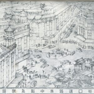
Figure 1. Architect Wong Yook-Yee plans for the New Nanjing Capital, 1929, Two Years of Nationalist China (1930)

Figure 1. Wong, Yook-Yee, Plans for the New Nanjing Capital, 1929, Two Years of Nationalist China (1930)

Figure 1., presents Y.Y Wong’s designs for the new Nanjing Capital in 1929, which is an interesting blend of Western architectural principles harmoniously intertwined with traditional Chinese aesthetics. At first glance, one is struck by an array of characteristics that might be expected when viewing places such as Washington D.C., London and Paris. Indeed, the sense of order and fluidity created by the architectural structures was an international standard, and one that Nanjing’s city planners hoped to replicate.2 Moreover, on closer inspection the image showcases structures that resemble Chinese characteristics, notably the upturned roofs in majority of the buildings. This fusion of modern western characteristics and classical Chinese motifs was a revolutionary in the realm of Chinese architecture.

A noteworthy feature of this image is the arrangement of the windows on the buildings. This detail is discussed by Charles Musgrove in his article ‘Building a Dream: Constructing a National Capital in Nanjing 1927-1937,’ as he highlights how the windows adhered to standardised patterns and were interspersed with rows of stone columns, which symbolised European and colonial neoclassical style.3 Indeed, as much of Musgrove’s article exclaims, Nanjings’ city planners were learning from Western sciences to help move into an era of modernity. The work of Y.Y Wong underscores the influence of spatial planning, not only in shaping physical landscapes but also in imbuing them with symbolism to help achieve governmental agenda.

Significantly, the time that this drawing was produced was during a pivotal juncture in China’s history with the establishment of the GMD. At the core of their mission was ‘national reconstruction,’ and Nanjing was at its epicenter. Indeed, throughout China’s dynastic history, rulers frequently employed spatial reorganisation as a means to reinforce their political authority, and the GMD were no exception.4 They ushered in a new cosmology, which established fresh conceptions of Chinese modernity and national identity.

It is crucial to note, that Y.Y Wong’s plans were not entirely replicated and Sun Yat-sen’s dreams were never lived, due to wider political and economic issues that came to fruition in the late 1930s and 1940s. From this one incontrovertible truth emerges: socio-political development is far more complex and nuanced process than often assumed, and therefore warrants close consideration.

Despite failure to fully implement the dreams of Y.Y Wong and Sun Yat-sen, Nanjing did undergo urban development through the creation of broad boulevards, the implementation of sewer systems, urban zoning, and the displacement of thousands of residents which profoundly altered its urban landscape.3 This did, in turn, create a new Chinese society, but one that had been influenced and shaped by western ideals of modernity; which leads one to a question of what China is. This iterates the need to understand what connects nation and urban place and, perhaps, what can be best deciphered from the case of Nanjing and Y.Y Wong’s drawing is that the creation of place is not static or an independent event but an active and multifaceted process.

  1. Carmen Tsui, ‘State Capacity in City Planning: The Reconstruction of Nanjing, 1927-1937,’ Cross-currents: East Asian History and Cultural Review, 1:1 (2012). [↩]
  2. Charles Musgrove, ‘Building a Dream: Constructing a National Capital in Nanjing 1927-1937’, in Joseph Esherick (ed)., Remaking the Chinese City: Modernity and National Identity, 1900-1950 (2002), p. 142. [↩]
  3. Mungrove, ‘Building a Dream,’ p. 148. [↩] [↩]
  4. Marijn Nieuwenhuis, ‘Producing Space, Producing China: A Critical Intervention,’ Centre for the Study of Globalisation and Regionalisation (2012), p.5. [↩]

Tracks and Fields – Oral Histories of Punggol

How much do urban planners know about the historical contexts of the spaces they organise? In this post, I engage in a rudimentary exploration of oral histories of the Punggol area in north-east Singapore and find that there existed no single historical context to speak of. Indeed, while histories of Punggol were similar to other planned areas in that they were richly variegated along lines of religious identification, dialect and surname association for the Chinese, Punggol inhabitants’ genealogies suggest a different orientation in the first place – that within the wider Malay Archipelago.

Two accounts of urban planning suggested to me the need to seek the perspectives of the proverbial walker. Firstly, Wooldridge’s nuanced and holistic chapter on Zeng Guofan’s image of Nanjing reconstruction demonstrated how literal reconstruction was state building.1 To be sure, Wooldridge’s grasp over the funding and bureaucratic machineries specific to Zeng worked well to evince different power systems when read with Yeoh’s chapter on the municipal government in Contesting Space.2 Here, Wooldridge was well aware of the limits of understanding the urban planner’s logic of reconstruction, noting the complex regional identities for the Nanjing intellectual elite who returned to Nanjing after 1865, even if the chapter eventually contained little in-depth exposition of these nuances.

While that served his point of top-down “reconstruction”, I instead considered Punggol, recently in Singapore the centre of a history exhibition at the opening of its new library. Contemporarily, it is known today as a housing neighbourhood town designed to court young families attempting to purchase public housing flats. Yet, what was this image reconstructed from?

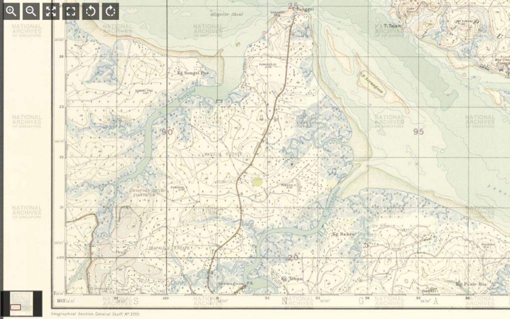
In Singaporean heritage projects, the spatialisation of Punggol has been the particularity of its “Track” system.3 However, when we examine maps from the National Archives of Singapore, the “Track” system first appears only on maps after 1959 – the year Singapore attained full internal self-government.4 Before that, topographical maps of Punggol were produced by the colonial-era Singapore Survey Department. These surveys were fixated on features such as railway widening lines and municipal boundaries. These maps also used the ‘mukim’ system; and between the first maps in the nineteenth century and 1959, little new information was added for each new addition for the focus was on land titles and land use.5

Correspondingly, this gulf is echoed in oral history interviews. On the other hand, oral history interviewees who were born before the 1950s used the Punggol ‘milestone’ markers as their way of spatialising Punggol.6 What remains similar in pre-1959 and post-1959 accounts, beyond the use of property and the association of land with ownership, is the exacting of demographic association down to specific streets for different dialect groups and surnames – a phenomenon Yeoh has elaborated on clearly in Contesting Space.

Yet, another primary source in 1957 presents a completely new dimension to Punggol history. In 1957, Muhammad Ariff Ahmad, a teacher based in Sekolah Melayu Ponggol (Ponggol Malay School), published Tok Sumang, the tale of his great-grandfather. In the English translation7 we learn that Tok Sumang had originated from Pahang and that his family had never been ‘fixed at one place’ – it was in the aftermath of war training on Tekong that he decided to move to ‘neighbouring Singapore, which was covered with dense forests and home to crocodiles and snakes.’ By 1891, Tok Sumang (‘always accompanied by his shovel and violin’) and his followers had agreed with the British that the land would never be taxed in exchange for the British construction of a road – the road that was built leading to the shore of Tanjong Punggol was named “Jalan Wak Sumang”. This was a different location of Punggol, not as an administrative unit in Singapore, and far from the contemporary understanding of the sovereign Singaporean nation-state as the center.

My comparison of Survey Department maps and different recollections of Punggol over time merely scratches the surface. In this case, the Surveyors’ maps did not merely lack markers of local knowledge. Between the Survey Department and internal self-government, topographical indicators said more of each administration’s goals than of Punggol’s historical particularity. The former emphasised land value, while the latter identified features of ‘community’ according to its own understanding, including landmarks such as ‘community centres’ and ‘police stations’. Secondly, the proliferation of a range of historical memories demonstrates one way in which the Lefebvrian idea of the “lived” can be actualised. Methodologically, I argue that there are far-reaching implications in using oral history to challenge the urban planner’s primacy. Oral histories and heritage culture, however state-directed either might potentially be, still spatialise a multiplicity of histories in ways that an urban planner’s map cannot.

  1. Chuck Wooldridge, City of Virtues: Nanjing in an Age of Utopian Visions, Seattle: University of Washington Press, 2015, pp. 117-149. [↩]
  2. Brenda Yeoh, Contesting Space in Colonial Singapore: Power Relations and the Urban Built Environment, Singapore: NUS Press, 2003, pp. 28–78. [↩]
  3. https://remembersingapore.org/2018/09/30/old-punggol-road-26-tracks/ [↩]
  4. Singapore Survey Department, Singapore 1961 – Tampines Accession Number TM000054_3. The use of “Track” is further replicated not just on topographical but electoral maps following this, with the post-1959 maps also taking care to mention vital community fixtures such as community centres and police centres – itself a change that deserves a discussion beyond the scope of this post. [↩]
  5. The Singapore Land Authority uses the system today, explaining that “Every land parcel in Singapore is uniquely identified by a lot number. This identifier has two components, namely the survey districts Mukim (MK) or Town Subdivision (TS) number and the lot number.” Mukim is a Malay word meaning ‘district’ with its roots from the Arabic مقيم (resident). [↩]
  6. Lee Chor Eck, Oral History Interview with Chai Yong Hwa Accession Number 000172. https://www.nas.gov.sg/archivesonline/oral_history_interviews/record-details/e0d5e6eb-115d-11e3-83d5-0050568939ad?keywords=Punggol&keywords-type=all. See especially reel 3 and reel 7. Maria Boon Kheng Ng, Oral History Interview with Hong Siew Ling, National Archives of Singapore . https://www.nas.gov.sg/archivesonline/oral_history_interviews/record-details/f09a160a-115d-11e3-83d5-0050568939ad?keywords=Punggol&keywords-type=all. See reel 3. [↩]
  7. Muhammad Ariff Ahmad (trans. Ahmad Ubaidillah), Tok Sumang, (Singapore: Geliga Limited, 1957). https://biblioasia.nlb.gov.sg/vol-19/issue-2/jul-sep-2023/tok-sumang-english/ [↩]

Map of Old Beijing: The Imperial Authority’s Essence, The Manipulation of Human

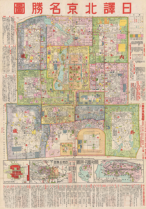
Figure 1. Beijing 1930 Chinese City Map or Plan of Beijing (Peking), China.

The city of Beijing has been the capital of imperial China since the Yuan dynasty. The map shown above was produced in 1930 by the Japanese. It portrayed the old urban structure of the Beijing city. The map consists of several rectangular blocks named 舊紫禁城 (the Forbidden City), 舊皇城 (the Imperial City), 內城 (the Inner City), and 外城 (the Outer City). The Forbidden City and the Imperial City were contained in the Inner City. The textual explanations provided on both sides of the map are about the categories of the marks on the map. Such details contribute to the analysis of the old urban spaces of Beijing. Through a meticulous examination of the map, accompanying the secondary materials in this week’s reading list, the blog posits that the historical urban layout of Beijing expresses a critical essence of the imperial authority: the manipulation of human mobility and activity. The imperial ruler utilised his authoritative power to regulate the mobility of the general populace in Beijing by arranging fixed residences for specific groups, and to restrict human activities by introducing social rules in different areas of the city.

First, the urban blocks of old Beijing required and designed by the imperial government mentioned above resulted in the segregation of different groups of people. For instance, on the map, the green part represents the residential location of famous individuals 著名處所. Most green parts on the map are in the Inner City, with only small parts found in the Outer City. According to Dong Madeleine Yue, the Inner City was the residence quarter of the “Manchu aristocrats and high officials”[1] as well as the “banner men and their families, who were responsible for guarding the palace and defending the capital.”[2] It is evident that the green parts in the Inner City belonged to influential nobility-related figures of the Imperial era. Yet, the residents of the green parts of the Outer city were different, especially in the Qing dynasty (1636-1912). Dong notes, “when the Manchus entered Beijing, they banished Han residents from the Inner City.”[3] It therefore can deduce that the small green parts of the Outer City mostly belonged to well-known Han figures as these people could not live in the Inner City. The ordinary people who did not play an important role in the imperial system were not allowed to be the residents of the Inner City. This division of the residence was not initiated by the ordinary people themselves, but rather imposed by the imperial authority. This resulted in the confinement of the ordinary to certain areas, shaping relatively fixed settlements for different groups of people and making the ordinary keep in captivity like livestock. The imperial administration at this moment manipulated human mobility and controlled the should-be division of people in Beijing by allotting the land to its residents.

Furthermore, the blog claims that the imperial manipulation of the urban design of the Outer and Inner cities contributed to the development and emergence of the theme zones. These organic parts in the urban area combined as an organic whole to support the entire imperial Beijing. The commercial area in the Outer City is a great example. When zooming in the map, it is hard to see the shops and stores directly associated with commercial activities within the Inner City. In contrast, in the Outer City, many shops of different categories are shown, such as 葱店 cong shop, 文宝楼 wenbao building, 纱纸坊 gauze paper shop. It is because that “no permanent businesses, guilds, or forms of entertainment were technically allowed in the Inner City,”[4] according to Dong. This situation was a product of the imperial strategy and manipulation. Dong once depicts the bustle of the Outer City’s business district: “the northern part of the Outer City was the bustling and prosperous commercial center for the imperial capital.”[5] Even if it did not designate the Outer City as an area with prosperous commerce, the arrangement of the Inner City urged development of the business in the Outer city as the Inner City could not “serve the daily needs of its residents,”[6] as Dong notes. The Inner City under the imperial control was a city without a synthetical life. In this case, the Outer City had to develop areas and social occasions to fill in the gaps in the Inner City living areas.

Overall, this blog intends to demonstrate the nature of imperial authority – the control of human mobility and activities. The separated blocks made up by imperial manipulation resulted in the segregation of ordinary people in designated locations. The imperial authority was the decisive agency in this process. As for the limitation of human activities, the urban spaces designed by the imperial government urged the development new areas and social occasions in the Outer City, the commercial area in particular. Such an area was an integral part of the efficiently functioning organic whole. However, the overall logic of constructing this organic whole was determined by the supreme control of the imperial authority, rather than the spontaneous generation of the ordinary people. Therefore, the urban plan of the city of Beijing was a manifestation of capability of the imperial authority rather than the human initiative.

[1] Madeleine Yue Dong, Republican Beijing: The City and Its Histories (Berkeley, 2003), p. 27.

[2] Dong, Republican Beijing, p. 27.

[3] Ibid.

[4] Ibid.

[5] Ibid.

[6] Ibid.

Japanese city-planning of Keijo (modern-day Seoul)

Korea is a milestone for a rapidly growing Japanese empire, as Japan took control of the peninsula after defeating Qing China and Imperial Russia, consolidating its status as a great power. In order to showcase their progress and power in relation to other imperial powers like Britain, France and Germany, the Japanese colonial government in Korea embarked on a plan to ‘modernise’ and ‘re-create’ Keijo, or modern-day Seoul. I argue that the Japanese had succeeded in laying out plans for a modern city not for the sake of the majority of its residents, but rather to benefit Japanese interests. I would focus on a primary source and support it with the reading: Assimilating Seoul by Todd Henry.

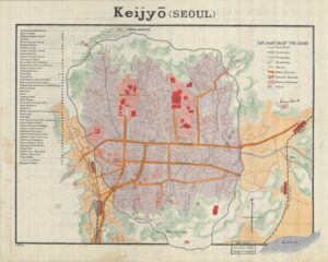
https://blogs.loc.gov/maps/2018/05/maps-of-seoul-south-korea-under-japanese-occupation/

The primary source I have chosen is a map of Keijo published by the Japanese Tourist Bureau in 1913, three years after the Japanese took full control of Korea and produced in English for foreign tourists. As we can see from the map, the orange signifies the main thoroughfares of the city and red represents what the Japanese colonial government deems as important sites. The important sites are well connected by the roads and supported by a tramway system, which implies that the colonial government puts the interest of the coloniser above the colonised, as evident in urban planning. Subsequently, given that the source is produced for a Western tourist, it aims to showcase Japan’s modernity which is showcased in the map that the areas labelled in red are all structures built for Japanese interests like railway stations besides a few Korean palaces and mausoleums. Anything related to Korean culture or promoting Korean distinctiveness is blurred out in the purple background or branch streets as labelled on the map.

One thing that caught my interest was the labelling of green spaces on the map. The garden-city movement became a cornerstone for the development of colonial cities to produce green spaces for the colonising power to relax. {{ Peter Hall Cities of Tomorrow: An Intellectual History of Urban Planning and Design since 1880 (2014 4th ed.), Ch 4 “The City in the Garden }} Within the city boundaries of Keijo, green spaces surround the neighbourhoods and all the government-associated buildings have an abundance of green space near them. This is to showcase the absence of chaos to imply power and dominance. {{ Henry, Todd A. Assimilating Seoul: Japanese Rule and the Politics of Public Space in Colonial Korea, 1910–1945 (2014) }} This is a practice inherited from the British in their colonial city planning as showcased in Robert Home’s book Of Planting and Planning. [[ Home, Robert K. Of Planting and Planning: The Making of British Colonial Cities (1996) ]]. 

The findings of the map are backed up by Henry’s argument that although the city-planning of Keijo was intended to integrate the Koreans as loyal Japanese subjects through Japanification, numerous factors, including the lack of funding, war and the failure of Japanese economic policy ensured the gap between Koreans and Japanese settlers persisted and that little was done in improving the housing conditions of over 50% of Koreans living in poverty. [[ Henry, Todd A. Assimilating Seoul: Japanese Rule and the Politics of Public Space in Colonial Korea, 1910–1945 (2014) ]]. Subsequently, the town planning committees were overwhelmingly dominated by Japanese settlers and the lack of organisation of the funding system implies that Keijo was hard to become a reality for the Japanese city planners in achieving their ultimate plan in promoting their own imperial urbanism. 

The Koningsplein: Urban Planning and Beautification in 1930s Jakarta

The 1930s saw a push by the Dutch colonial government of Indonesia to “modernise” the the country’s urban spaces. In 1934 a Town Planning Commission was established with the aim of developing urban planning regulations and guiding redevelopment. It presented its findings in 1938, advocating for the replacement of ad hoc urban development with a more centralised, methodological approach. They felt this would produce “harmonious” towns which would surely become reflected in the character of its inhabitants.1

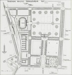
Source: IBT Locale Techniek (1937:  p. 161)2

This 1937 plan for renovation to the Koningsplein, modern day Merdeka Square in central Jakarta, can be seen as symptomatic of the new philosophies of city planning sweeping Dutch Indonesia during this period. The plans centre on the town hall, placed amongst open green squares, at the junction of two boulevards. A stadium is situated in the south-east quadrant of the square and other notable buildings are visible along the edges, such as the Java Hotel and the Governor General’s palace.

One aspect of this plan which is immediately obvious is the desired beautification of the Koningsplein. The tree-lined avenues and inclusion of an intricate gardens in the north-western section of the square attest to the fact that this space was intended to inspire appreciation for the natural. Thomas Karsten, a prominent urban planner at the time, advocated for the inclusion of nature within the city, as long as it was carefully zoned and remained within its bounds.3

Colombijn and Cote argue that the reason for this attention to natural beauty is that urban beauty was intrinsically linked with the quest for order and control in colonial spaces.4 Order and organisation were seen as beautiful and beauty was believed to engender civility among citizens. The embodiment of this philosophy in the Koningsplein plan can be seen in the manicured lawns and geometrically divided sectors of the square. Ordered natural beauty within the square was intended to inspire an ordered society around it.

This approach to city planning echoes the City Beautiful movement, a philosophy which came to prominence in North America in the late 19th and early 20th centuries. Although the application of the City Beautiful movement necessarily differed by context, Peter Hall argues that its core tenant was the use of architecture and planning as theatre. As part of this movement, investment in urban beautification became a way to signal different values to a cities inhabitants and influence them in a positive fashion.5

The influence of the City Beautiful movement can be seen here, not only with the structured nature of the square, but also in the intended grandeur of the Town Hall and the Stadium. By placing these buildings in the middle of the square, surrounded by open space, they become the focal points of the space. Thus, the plan attempts to inspire respect and admiration for these symbols of Dutch government and modernity and, by extension, legitimise the colonial government.

Due to the Japanese invasion of Indonesia and the advent of World War II, these plans, along with many others, were never enacted . After the conclusion of the war and the Indonesian Independence movement, the Koningsplein was renamed Merdan Merdeka, or “Independence Square”. It was then redesigned and now consists of four diagonal streets radiating out from a new central National Monument.

The history of Merdeka Square and the Koningsplein is an interesting study in the shifting values of urban spaces. Once a key symbol of colonial aspirations for “modernisation” and order, it has since transformed into one of the country’s most visible monuments to independence. However, it has remained a tool of the government throughout, a way for regimes to articulate their priorities and values to the masses.  As such, though the specific values it transmits may have shifted, it can be seen to still embody the early 20th century philosophies of urban planning as theatre.

  1. Pauline van Roosmalen, ‘Netherlands Indies Town Planning: An Agent of Modernization (1905-1957)’ in Cars, Conduits, and Kampongs, eds. Freek Colombijn and Joost Cote (Boston, 2015), p. 98. [↩]
  2. view (colonialarchitecture.eu) [↩]
  3. Freek Colombijn and Joost Cote, ‘Modernization of the Indonesian City, 1920-1960’ in Cars, Conduits, and Kampongs, eds. Freek Colombijn and Joost Cote (Boston, 2015), p. 3. [↩]
  4. Ibid. [↩]
  5. Peter Hall, Cities of Tomorrow: An Intellectual History of Urban Planning and Design since 1880 (2014), p. 236. [↩]

Curating First Impressions: Exploring the Seascapes of Sadahide’s Yokohama prints and their presentation of the Early Treaty Port Era

Sadahide’s Yokohama Prints or Yokohama-e are the product of a significant shift in the spatial context within a plethora of Japanese ports during the 1850s. These artworks illustrate the spatial dynamism within the Treaty Port’s commercial and social areas. In spite of the dangers of being a foreign merchant and complex spatial barriers incurred by the legal segregation of land and access to littoral space in Yokohama, Sadahide’s exoticised portrayals of the Treaty Port reflect the process in which people’s sense of place is curated and altered. The Harris Treaty signed aboard the U.S. warship Powhatan, came into effect in 1859 and catapulted Yokohama into the international economy.1

The pressured opening of Japanese trading ports induced the restoration of the social issues of human trafficking, and the violation of Japan’s domestic security.2 Foreign traders and officials hastily constructed entertainment venues and brothels to cater to their sailors’ needs.3 They were also known to venture deeper into the inlets of Edo Bay beyond the boundaries of the Treaty Ports and these outings often ended in violence against the foreigners.4 These acts began to break down Japan’s status society and, combined with the continued commercial concessions enforced on the imperial court, sparked acts of violence by the Bakufu against foreigners.5 The realities of Treaty Port life are largely excluded from Sadahide’s exploration of Treaty Port life and focus on the economic vitality, cultural sophistication, and social cohesion of the Treaty Port.

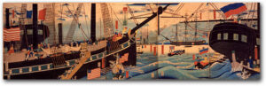
The artwork “Pictures of Western Traders at Yokohama Transporting Merchandise”, produced in 1861, consists of five weed blocks attached that capture Sadahide’s portrayal of the age of commerce in Yokohama’s Treaty Port. This print depicts five ships, each flying a flag that distinguishes them as one of the five Western members of the Ansei Treaties. Traditional Japanese woodblock printing emerged a century prior to the signing of The Ansei Treaties in 1858, which opened access to Japan’s trading ports after two centuries of seclusion.6 The national flags on each ship in Sadahide’s print are those of the United States, Britain, France, the Netherlands, and Russia. These countries established trading rights, port access, and the application of extraterritoriality between Japan themselves.7 This arrangement was arguably forced upon Japan by the United States by intimidating the shōgunate by periodically sending warships into Edo Bay.8

Despite Japan’s coercion into the treaty, its re-introduction into the global market and the high value of imported goods transiting through the Treaty Ports is illustrated thoroughly in “Pictures of Western Traders at Yokohama Transporting Merchandise”.  A mixture of steam and sailboats are visible. Inside the port holes, small sightings of the internal luxury are discernable. Many foreign women accompanying their husbands are visible, despite their scarcity in this period.9 A diversity within the staff is also depicted, on the American boat, an Indian male, distinguished by his turban, is pulling in the rigging. Goods are overflowing on the decks of each ship and in the small rowing boats on the water. Overall, the seascape is overwhelmingly a Westernised image. Sadahide celebrates a bustling yet peaceful image devoid of the local xenophobia that was rife towards the inhabitants of the Treaty Ports.10 This image is also thought to be inspired by a print published in the Illustrated London News half a year before this print release.11 Sadahide’s potential imitation of the British artist illustrates that Sadahide is able to manipulate Western artistic fashions to appeal to foreign consumers and curate a specific and positive sense of place within the viewer. 

Figure 1: “Pictures of Western Traders at Yokohama Transporting Merchandise”,  by Sadahide (1861).

Figure 2: Harbour Scene at Naples, from Illustrated News London.

The print entitled “A Picture of Sunday in Yokohama”, released in 1860 illustrates the spatial exclusivity of the Treaty Port.12 The image depicts a procession of the foreign inhabitants of Yokohama’s Treat Port including a brass band, the wives of merchants and again the flags of the five nations involved in The Ansei treaty. In the background, the merchant ships and one of the jetties can be seen, reinforcing the semi-colonial assertion of power the five nations have enforced on Yokohama. In Neo-Confucian conceptions of moral behaviour and within Tokugawa society, the role of merchants and handling money is associated with improper ethical practice and is a lowly occupation.13 Sadahide is perhaps mocking the Western ritualised celebration of the merchant class and contesting their perceptions of how they assert power over Yokohama’s littoral space by implying they are morally unrefined. This is a significant example of how perceptions of space and who holds power in these places may be interpreted by foreigners and Japanese people may interpret Sadahide’s representations in his prints differently.

Figure 3: “A Picture of Sunday in Yokohama”, by Sadahide (1860).

To conclude, Sadahide’s artworks exude a sense of calmness and present a highly sterilized image of Yokohama to engender Japan with the prestige and financial prosperity it aimed to embody in the eyes of Western visitors.14 In contrast with the dangerous and male-dominated reality of Yokohama’s Treaty Porty at this time, Sadahide provides an enchanting, stylised depiction of semi-colonialism. During the messy, infancy of the Treaty Port system, foreign merchants began to test the pliability of the spatial boundaries that they had assigned. Resultantly, markets for prostitution, and “coolie” labour were drawn to Yokohama’s shores to facilitate the growing market.15 As tensions rose between the British and Japanese in their quests for legal hegemony over legalities that transgressed the port’s limits, Sadahide continued to print visuals that appealed to Western foreigners residing and travelling through. There is a constant exoticism and beautification of the Treaty Port, the harbour, and the merchants.

  1. John Dower, “Yokohama Boomtown: Foreigners in Treaty Port Japan (1859-1972), Available at: yb_essay04.html (Accessed: 18/09/23) [↩]
  2. Daniel Botsman, ‘Freedom without Slavery? “Coolies,” Prostitutes, and Outcastes in Meiji Japan’s “Emancipation Moment”’, The American Historical Review 116, no. 5 (2011): 1323–47. [↩]
  3. Marius Jansen, The Making of Modern Japan, (Harvard, 2022), p.317. [↩]
  4. Jansen, The Making of Modern Japan, pp.317-319. [↩]
  5. Jansen, The Making of Modern Japan, pp.314-317. [↩]
  6. Dower, “Yokohama Boomtown”, available at: yb_essay04.html (accessed: 18/09/23) [↩]
  7. Jeremy Taylor, “The Bund: Littoral Space of Empire in the Treaty Ports of East Asia,” Social History 27, no. 2 (2002): 125–42 [↩]
  8. Todd Munson, “Imperialism and Indomedia in Bakumatsu Japan: The View from Treaty Port Yokohama”, PhD Thesis, (University of Indiana, 2004) pp.50-53 [↩]
  9. Dower, “Yokohama Boomtown”, available at: yb_essay04.html (accessed: 18/09/23) [↩]
  10. Jansen, The Making of Modern Japan, p.317 [↩]
  11. MIT Visualising Cultures, “Boomtown”, Available at: https://visualizingcultures.mit.edu/yokohama/yb_essay04.html, (Accessed 18/09/23) [↩]
  12. MIT Visualising Cultures, “Boomtown”, Available at: https://visualizingcultures.mit.edu/yokohama/yb_essay04.html (accessed:18/09/23) [↩]
  13. Munson, “Imperialism and Indomedia in Bakumatsu Japan: The View from Treaty Port Yokohama”, p.156 [↩]
  14. Munson, “Imperialism and Indomedia in Bakumatsu Japan: The View from Treaty Port Yokohama”, p.147. [↩]
  15.  Botsman, ‘Freedom without Slavery?”: 1323–47. [↩]

Asia’s Burial Grounds: The Last Bastions of Resistance Against the Will of the State?

The burial ground, throughout the world, has for centuries been considered a sacred place. At the physical level, they provide the setting for laying loved ones to rest peacefully and for paying respects and remembering those who came before us. Throughout history, they can be seen as symbolic sites of power, memory, and identity. Lily Kong and Brenda Yeoh’s The Politics of Landscapes in Singapore: Constructions of ‘Nation’, however, has been a landmark publication analysing their competing role against the will of the ‘modernising state’.1 Using this text as a foundation, this post aims to show that whilst one might expect such personal, spiritual and sacred spaces to contest modernisation and urbanisation, they have offered little resistance, especially in an Asian spatial context.

When studying the physical manifestations of Chinese burial practices and rituals, one is struck by the immensity of tradition, laws and its geomancy. The dead are considered to play an important role in family life, with Chinese custom believing them to have an important role in looking over their ‘earthly descendants’.2 In accordance with feng shui, the Chinese burial space is carefully considered, planned and maintained.3 In China particularly, perhaps more so than in other places, they are sites of familial kinship and loyalty, of home comfort and spirituality and of personal exchange between the living and dead. As Kong and Yeoh have noted the importance of burial site configuration in ensuring ‘benign influences’ are drawn from earth and transmitted to descendants of the dead.4 Any interference with such a custom, would bring risk to the wellbeing of the deceased’s family. With these facts in mind, such sacred sites are widely considered to be immune from external influences and government intervention.

Yet, despite this, such Chinese sites and their stakeholders offered little resistance when modernisation and urbanisation efforts by the Singaporean government commenced in the second half of the 20th century. Such sites, which occupied large areas of physical space, and which many considered to be focusses of disease, proved to be obstacles to expanding townscapes and cityscapes and land acquisition program. This was especially the case with specific regard to Singapore’s relative shortage of land to develop. Whilst some Chinese clans, the YFFK and SHHK sought a level of compensation for their burial grounds being disrupted or moved5, the Singaporean example shows these sacred spaces to have offered little challenge to the will of the state.

To move up the chain of abstraction, it is important to perhaps consider this phenomenon from an alternative, more critical perspective. Whilst Kong and Yeoh note that practices of cremation and the use of columbariums were promoted as a valid and useful alternative to traditional funerary sites, this lack of resistance may also have been a by-product of changing attitudes and perspectives amongst Chinese huangxi themselves. Whilst Kong and Yeoh cite several accounts that highlight the sentimentality in the very beauty, ‘finding’ and ‘activity’ of tending relative’s graves, there is evidence that communities throughout Asia felt less affinity to family and community and instead felt part of a larger, modern and cosmopolitan society. Su Lin Lewis’ Cities in Motion brings to light the rise of ‘globalisation in the public sphere’ and a growing sense of cosmopolitanism throughout Asia.6 Organisations such as the YMCA, YWCA and the Rotary helped foster feelings of community service and international consciousness across Asia. To provide a counter argument to Kong and Yeoh, perhaps communities felt less compelled to engage in the traditions of burial and with ancestral or clan connections and instead felt more kinship to the state.

If one critically unpacks the physical ritual of tending to the dead, such an activity often involves time, offerings and is a practice for entire families or communal groups. However, with modernisation comes displacement, geographical fragmentation and greater restrictions on time. Accompanying the building of new towns comes the relocation of communities and the foundation of new lives, ideas and identities. Affinity to home, albeit not lost, can become more ambiguous and obtruse. Whilst the ritual of visiting and supervising sacred spaces should not be underestimated in the spirituality and comfort it can bring to people, Kong and Yeoh’s analysis reveals the success the Singaporean example had in shaping the material landscape of columbariums to accommodate traditions and still offer meaning for loved one’s of the dead. Indeed, between in 1962, the Mount Vernon Crematorium was performing four cremations per week and by 1995 it was averaging 21 cremations per day.7  Niches could be selected and adjusted to suit the personal preferences of the family, providing an acceptable and more financially viable alternative.8

Whilst this blog has built upon and provided a critique of Kong and Yeoh’s article, further inquiry into the relationship between burial sites, national identity and the state would prove incredibly fruitful. In the contemporary world, disagreements still take place over burial and memorial sites. The removal of George Floyd’s memorial in Minneapolis in 2021 received much criticism with demonstrators protesting that it damaged the city’s collective memory of the incident.9 Such an example proves the power that such sites can have as symbols of resistance, community and identity. Burial grounds have the potential to be places of power, struggle and memory and will continue to provide a fascinating lens through which to study civil autonomy and the will of states.

  1. Lily Kong and Brenda S. A. Yeoh, The Politics of Landscapes in Singapore: Constructions of ‘Nation’, (Syracuse, 2003) [↩]
  2. Wilson, B. D., “Chinese Burial Customs in Hong Kong”, Journal of the Hong Kong Branch of the Royal Asiatic Society 1 (1960), p. 115 [↩]
  3. Michael Paton, Five Classics of Fengshui: Chinese Spiritual Geography in Historical and Environmental Perspective, (2013) [↩]
  4. Lily Kong and Brenda S. A. Yeoh, The Politics of Landscapes in Singapore: Constructions of ‘Nation’, (Syracuse, 2003), p. 53 [↩]
  5. Kong and Yeoh, The Politics of Landscapes in Singapore, p. 65 [↩]
  6. Su Lin Lewis, Cities in Motion, (Cambridge, 2016), p. 120 [↩]
  7. Kong and Yeoh, The Politics of Landscapes in Singapore, p. 61 [↩]
  8. Ibid, p. 72 [↩]
  9. Deena Winter, ‘Minneapolis Removes Memorials and Barricades From ‘George Floyd Square’, (2021), https://www.nytimes.com/2021/06/03/us/george-floyd-memorial-minneapolis.html [↩]

How convincing is the ‘From-race-to-class-segregation’ argument when discussing if income was the significant factor affecting the makeup of neighbourhoods in desegregated Indonesia 1930-1960?

When examining city planning in the Southeast Asian colonial context, a commonly held view is that ethnic or racial categories formed the main division of residential areas, reinforcing residential patterns that mirrored ethnicity divisions in society. Historian, T.G. McGee describes the colonial city as a “mosaic of ethnic quarters” with this trend of separation between different ethnicities persisting until the 1960s[1]. Although the Raffles Town Plan was based upon the spatial layout of Singapore, it is a great example of how spaces were reserved for a separate and specific race and function: i.e., the “European Town”, “Arab quarters” and “Kampong” areas within the colonial city[2]. Before independence in Indonesia, the same historical quarter system existed.

Ethnic divisions in colonial times were made more visible through the legal classification between indigenous, foreign Orientals and Europeans. The law code that was developed in the mid 19th century required strict categorisation of a citizen as: European, non-European (which included Chinese and indigenous) and Foreign Oriental, which developed as a category later in the period. However, as the categories of classification expanded, so did their flexibility; you could apply to move categories based on a number of factors including income and profession. For example: in 1899 Japanese residents successfully transferred from ‘foreign Orientals’ to the ‘European’ category. In essence, this development show us that although racial distinction was common within everyday colonial life, it was not stringent in the same way of the African colonies.

Dutch historian Freek Colombijn proposes the ‘From-race-to-class-segregation’ thesis which postulates that residential patterns were strongly influenced by changes in the social status system. After independence in Indonesia, and de-segregation of society, Colombijn argues the main factor determining residential patterns and their divisions was no longer ethnicity but income and economic status. His maintains that even before independence, ethnic groups lived in more mixed communities than given credit for. For example: in Subraya, indigenous people lived in neighbourhoods designated for Chinese and Arabs[3]. This was because traders chose to live in the same communities; it was their profession in common (i.e., Earthenware and brass workers) that brought them to live in the same neighbourhood. Therefore, he promotes the idea that racial segregation as the basis for residential patterns is over-emphasised within the historiography because of the evidence supporting the claim that professional specialisation had an influencing factor on a person’s motivation to live in a specific neighbourhood.

In this way, it can be said that living in a neighbourhood based on class and economic status, was a general continuation of the pattern of living in areas based on professional specialisation. People that worked in the same jobs, would generally earn the same wage and therefore form a class amongst themselves. After conducting several interviews with those living in independent Indonesia, the author found a recurrent theme to be that housing was found through social networks, especially through work colleagues, strengthening the argument that it was social class that dictated residential patterns in the later twentieth century.

A key problem with the theory is that the issues of race and social class are strongly related to one another. Within the colonial system, native Indonesians failed to receive the same level of education and would often need to begin working earlier in their lives to support their families. With no access to high paying jobs, and limited accessibility into white collar work, the colonial system effectively froze the social mobility of the country. Therefore, the ‘from-race-to-class’ thesis becomes less convincing because even after independence was granted, natives born, and non-European citizens were not trained to take up jobs that were higher paying.

To answer the question first set out, I agree with the author that the ‘from-race-to-class’ thesis is a convincing argument, to an extent. I think that it has been proven to a reasonable degree that there were normalised exceptions to the racial classifications in society, such as indigenous people living in Arab and Chinese quarters. Although the categories existed and intermixing casually was not the norm, the racial segregation was not as embedded in society as African colonies which makes it more realistic to think that people would choose to reside in neighbourhoods based on other factors such as profession and income. I believe that there are faults with the argument too; firstly, that it invites a pro-Dutch perspective within the context of Indonesian colonialism, which is problematic. Secondly, that it infers after Indonesia gained independence that social mobility would be fluid and that the obstacles put in place by the colonial government would be gone just because the government was. Although there was a white-collar workforce of Indonesians, these were men born into their privileged positions and challenges remained for indigenous people to become qualified and educated to apply for bureaucratic jobs. Nevertheless, this thesis’s greatest strength is the focus on the changing status and economic power of the emergent middle class. These were the families who began working in fortuitous industries (i.e., traders and workmen) which encouraged them to move to neighbourhoods with people which they worked.

[1] McGee, T.G, The Southeast Asian City; A social geography of primate cities of Southeast Asia. London, Bell.

[2] Plan of the Town of Singapore, Lieut Jackson, Survey Department Singapore, Survey Department Singapore (London, 1828).

[3]Colombijn, Under Construction: Race, Class and Segregation, p.85

Beyond Objectification: The Role of Women in the Wartime Economies of Japan and Vietnam

While stationed in Yokosuka during the American occupation of Japan, the cartoonist Bill Hume began drawing cartoons featuring a character named “Babysan,” a highly sexualized caricature of Japanese women.  Babysan: A Private Look at the Japanese Occupation was published in 1953 and in 1965, Tony Zidek published a similar collection of cartoons called Choi Oi! The Lighter Side of Vietnam, while serving in the Vietnam war.  Published as “morale-building” material for deployed soldiers as well as nostalgic accounts for those who had returned to the US, the books depict the interactions of American soldiers with Japanese and Vietnamese women.  Looking beyond their overt objectification of women, they provide insight into the roles these women played in the economic systems which developed under the American presence.

The women depicted in Babysan belong to “the greyer category of what were sometimes referred to as onrii (from ‘only’ or ‘only one’), or women who engaged in serial, ostensibly monogamous relationships with ‘only one’ uniformed lover at a time, and who received various forms of material compensation in return.”1 Although Japanese women are portrayed primarily as objects of American consumption, the cartoons suggest that women held considerable power over financial transactions.  One cartoon features Babysan remarking, “No dependent?” as she looks over her boyfriend’s tax form.2 Hume describes how the boyfriend is not only expected to support Babysan financially, but in some cases her family as well.  Women are depicted as being dependent upon the support of American soldiers, but also as financially intelligent and using their “resources” (American soldiers) as effectively as possible.  Hume states that, “Japanese women are traditionally the holders of the purse strings, so Babysan knows of many more practical ways of using his okane.”3 Not only do women control the “purse strings” of American soldiers, but Hume suggests that many women had multiple American partners and therefore multiple sources of income.

To ensure their financial security, women relied on networks of information to learn the whereabouts of their partners.  In Babysan, Hume describes how “She and her girl friends, with apparently the help of everyone else in town, have a highly efficient communication system that the Americans call the grapevine,” a system which “gives them a forecast of their economic future.”4 Although Babysan makes no direct references to black markets or prostitution, they were highly successful around American bases and likely relied on similar systems of communication.  Around 70,000 women were employed legally as prostitutes and thousands more worked on a private basis.5 Each of these ventures relied on the capital provided by Americans, combined with an internal network of information.

Like Japan, Vietnam saw the rise of black market operations following an influx of American soldiers.  “American goods dominated storefronts and street vendors’ stands in Saigon, Hue and Da Nang, putting a tight pinch on local manufacturing which could not compete. American soldiers and civilians, and the United States government, had money to spend… Vietnam realised with equal cleverness that there was money to be made.”6 As black markets flourished in Vietnam, so did currency fraud which was facilitated by informal street vending stalls or “Howard Johnsons.”  One cartoon from Choi Oi remarks, “Saigon’s ‘Howard Johnsons’ do have a flair for providing ‘extra’ services also.  Numbered among them is the illegal exchange of money.”7 Another cartoon depicts a Howard Johnson advertising the daily exchange rate of piastres to dollars and an exchange between the woman running the stall and an American soldier.8

Vietnamese, particularly women, often played the role of go-between in these schemes. For example, a soldier might get wind of an upcoming MPC conversion date… A soldier would take X piastres to the US exchange at a particular installation and purchase US dollars. He (or his Vietnamese house servant or girlfriend) would then take the dollars to the black market and purchase X + Y piastres, Y being the difference between the rate at the American exchange and the black market rate of exchange.9

Women were both “go-betweens” for Americans as well as the ones exchanging money and operating stalls.  Their role extended beyond that of wife or girlfriend, and even beyond the Vietnam War itself.  After socialist forces took and renamed Saigon, “In Ho Chi Minh city women from the middle and upper classes were involved more in socio economic activity, they were also more active in business and financial transactions, and in the black market.”10 Even after the American presence in Vietnam disappeared, women continued to play important roles in the economic systems that had taken hold as a result of the war.

While the women in Babysan and Choi Oi appear as sexualized objects of humor and entertainment, the cartoons suggest that their real role in post-war and wartime economies was varied and complex.  The American presence in Japan and Vietnam was a major contributing factor to the economic hardship faced by Japanese and Vietnamese women, but while American soldiers were present, women used soldiers both as a source of income and as a way to make the most of the financial situation caused by their presence.

  1. Kim Brandt, “Learning from Babysan,” review of Babysan, by Bill Hume, Japan Society, 3 https://aboutjapan.japansociety.org/learning-from-babysan#sthash.pt5iJI39.dpbs. [↩]
  2. Bill Hume, Babysan: A Private Look at the Japanese Occupation (Tokyo: Kasuga Bocki K.K., 1953), 56-57. [↩]
  3. Hume, Babysan, 92. [↩]
  4. Ibid., 98. [↩]
  5. Brandt, “Learning from Babysan,” 2, 9. [↩]
  6. William Allison, “War for Sale: The Black Market, Currency Manipulation and Corruption in the American War in Vietnam,” in War & Society 21 no. 2, (2003): 135. [↩]
  7. Tony Zidek, Choi Oi! The Lighter Side of Vietnam (Rutland & Tokyo: Charles E. Tuttle Co., 1965), 34. [↩]
  8. Zidek, Choi Oi!, 35. [↩]
  9. Allison, “War for Sale,” 146. [↩]
  10. Tran Phi Phuong, “Work and family roles of women in Ho Chi Minh City,” in International Education Journal 8 no. 2, (2007): 290. [↩]