How convincing is the ‘From-race-to-class-segregation’ argument when discussing if income was the significant factor affecting the makeup of neighbourhoods in desegregated Indonesia 1930-1960?

When examining city planning in the Southeast Asian colonial context, a commonly held view is that ethnic or racial categories formed the main division of residential areas, reinforcing residential patterns that mirrored ethnicity divisions in society. Historian, T.G. McGee describes the colonial city as a “mosaic of ethnic quarters” with this trend of separation between different ethnicities persisting until the 1960s[1]. Although the Raffles Town Plan was based upon the spatial layout of Singapore, it is a great example of how spaces were reserved for a separate and specific race and function: i.e., the “European Town”, “Arab quarters” and “Kampong” areas within the colonial city[2]. Before independence in Indonesia, the same historical quarter system existed.

Ethnic divisions in colonial times were made more visible through the legal classification between indigenous, foreign Orientals and Europeans. The law code that was developed in the mid 19th century required strict categorisation of a citizen as: European, non-European (which included Chinese and indigenous) and Foreign Oriental, which developed as a category later in the period. However, as the categories of classification expanded, so did their flexibility; you could apply to move categories based on a number of factors including income and profession. For example: in 1899 Japanese residents successfully transferred from ‘foreign Orientals’ to the ‘European’ category. In essence, this development show us that although racial distinction was common within everyday colonial life, it was not stringent in the same way of the African colonies.

Dutch historian Freek Colombijn proposes the ‘From-race-to-class-segregation’ thesis which postulates that residential patterns were strongly influenced by changes in the social status system. After independence in Indonesia, and de-segregation of society, Colombijn argues the main factor determining residential patterns and their divisions was no longer ethnicity but income and economic status. His maintains that even before independence, ethnic groups lived in more mixed communities than given credit for. For example: in Subraya, indigenous people lived in neighbourhoods designated for Chinese and Arabs[3]. This was because traders chose to live in the same communities; it was their profession in common (i.e., Earthenware and brass workers) that brought them to live in the same neighbourhood. Therefore, he promotes the idea that racial segregation as the basis for residential patterns is over-emphasised within the historiography because of the evidence supporting the claim that professional specialisation had an influencing factor on a person’s motivation to live in a specific neighbourhood.

In this way, it can be said that living in a neighbourhood based on class and economic status, was a general continuation of the pattern of living in areas based on professional specialisation. People that worked in the same jobs, would generally earn the same wage and therefore form a class amongst themselves. After conducting several interviews with those living in independent Indonesia, the author found a recurrent theme to be that housing was found through social networks, especially through work colleagues, strengthening the argument that it was social class that dictated residential patterns in the later twentieth century.

A key problem with the theory is that the issues of race and social class are strongly related to one another. Within the colonial system, native Indonesians failed to receive the same level of education and would often need to begin working earlier in their lives to support their families. With no access to high paying jobs, and limited accessibility into white collar work, the colonial system effectively froze the social mobility of the country. Therefore, the ‘from-race-to-class’ thesis becomes less convincing because even after independence was granted, natives born, and non-European citizens were not trained to take up jobs that were higher paying.

To answer the question first set out, I agree with the author that the ‘from-race-to-class’ thesis is a convincing argument, to an extent. I think that it has been proven to a reasonable degree that there were normalised exceptions to the racial classifications in society, such as indigenous people living in Arab and Chinese quarters. Although the categories existed and intermixing casually was not the norm, the racial segregation was not as embedded in society as African colonies which makes it more realistic to think that people would choose to reside in neighbourhoods based on other factors such as profession and income. I believe that there are faults with the argument too; firstly, that it invites a pro-Dutch perspective within the context of Indonesian colonialism, which is problematic. Secondly, that it infers after Indonesia gained independence that social mobility would be fluid and that the obstacles put in place by the colonial government would be gone just because the government was. Although there was a white-collar workforce of Indonesians, these were men born into their privileged positions and challenges remained for indigenous people to become qualified and educated to apply for bureaucratic jobs. Nevertheless, this thesis’s greatest strength is the focus on the changing status and economic power of the emergent middle class. These were the families who began working in fortuitous industries (i.e., traders and workmen) which encouraged them to move to neighbourhoods with people which they worked.

[1] McGee, T.G, The Southeast Asian City; A social geography of primate cities of Southeast Asia. London, Bell.

[2] Plan of the Town of Singapore, Lieut Jackson, Survey Department Singapore, Survey Department Singapore (London, 1828).

[3]Colombijn, Under Construction: Race, Class and Segregation, p.85
Denechofu as the Blueprint for the Modern Garden City in Japan: What made it different?

Today it is known as the “Japanese Beverley Hills”, but the city of Denenchofu was originally founded on socialistic principles of Ebenezer Howard and realised through the Japanese perspective of developer Eiichi Shibusawa. The city itself is synonymous with words like modern and high quality but how did it reach this star status? Are there aspects of its planning, construction and birth that set it apart from its peer suburbs such as Sakura Shinmachi (Sakura New Town), Meguro Bunkamura (Meguro Cultural Village)?

Within this blog post, I will explore these questions and attempt to answer how the socialistic notions of Howard’s Garden City invariably heightened the success of the city in addition to the instrumental job that Eiichi Shibusawa, played in its creation. Thus, allowing it to reach champion status. I will begin with a dissection and analysis of unique points of interest within Howard’s notion of a Garden City.

“The Garden City is not a suburb, but the antithesis of a suburb: not a mere rural retreat but a more integrated foundation for an effective urban life.”(1)

Howard’s concept of a garden city came into play in 1898 as a socioeconomic planning strategy with the central aim of combatting the ills of the industrialized city(2) . Within this theory, it is clear that Howard and his theory are heavily indebted to a socialist ideology in which the economic viability of the city comes far behind the social and personal fulfilment that its residents should enjoy. His utopian ideas of the Garden City were heavily inspired by Edward Bellamy and his publication ‘Looking Backway (1888)(3). Thus, the garden city was intended to provide an alternative to the suburbs economic and social homogeneity by representing all classes and values(4) .

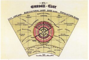
In the map below, some noteworthy features of Howard’s Garden City are evident.
Firstly, the ratio of city to greenbelt is rather unique; 1,000 acres at the centre for 5,000 of green space. This shows how highly Howard valued parkland space to a low urban population, similarly this is shown in his estimation of a population of 32,000. Historians can also take note of the concentric circles and wedges that form an economic arrangement between producer and consumer: cow pastures, fruit farms, brickfields and asylums/homes show a balance, rather than an overwhelming commercial city.

Figure 1: Ebenezer Howard, diagram of the garden city with central park and rural belt. From Garden Cities of To-Morrow (1898)

Historian Ken Oshima makes it clear that although Denenchofu’s founders aimed to create a garden suburb as per Howard’s vision, it needed to be adapted to Japan. In many ways, what secured the success of Denenchofu was Shibusawa’s philanthropic intentions and concurrence that the development should not driven by economic forces. Thus, paralleling Howard’s social spirit and civic activism(5). Instead of the city being planned to depend on the economic interests of the land companies, lending institutions, or railways companies, it was dependent on a non-profit development company headed by Shibusawa. It was certainly a risk not to build a city based on its potential economic output, but that’s what made Denenchofu unique.

Shibusawa used his highly regarded reputation to raise capital and eventually support for the development. Moreover, Denenfochu’s success could also be attributed, at least in small weight to bursting population of Tokyo and the natural disasters occurring from 1900-1920s that increased the demand for housing outside the city of Tokyo. Nevertheless, the significance of the design of the city should not be overlooked: the coherent street pattern, and hybridization of Western-Japanese style gave the city a sense of urbanity without feeling like a foreign imposed model.

One may argue that Shibusawa did work against Howard’s vision in some ways. For instance: he sold plots of land rather than it being owned communally, in addition, it was less a mix of classes than a neighbourhood for the rising middle class. By 5th May 1928, the Denentoshi Corporation sold all land parcels, and the corporation slowly abandoned its idealistic values for more capitalistic ones(6). Howard’s original concept of an anti-suburb with a degree of self-sufficiency slowly transformed into an oasis of a capitalist society. Its initial success is what caused the demand to grow, which consequently caused the price of land in the city to rise – and so capitalism sang its song. Nevertheless, we can attribute Howard’s ideas to the early success of Denenfochu as a garden city; and Shibusawa’s success as a developer for making it an oasis that capitalism then transformed into the less pure form of a ’garden city’. At the very least, we can reflect on Denenchofu as an actualized fusion of East and West that is still relevant today.


(1) Lewis Mumford, “The Garden City Idea and Modern Planning,” in Ebeneezer Howard, Garden Cities of To-Morrow (London, 1945) p.35

(2) Ken Tadashi Oshima, Denenchofu: Building the Garden City in Japan p.140

(3) http://architectureandurbanism.blogspot.com/2010/10/ebenezer-howard-garden-cities-of-to.html

(4) Ken Tadashi Oshima, Denenchofu: Building the Garden City in Japan p.141

(5)Christensen, American Garden City, p.140.

(6) Ken Tadashi Oshima, Denenchofu: Building the Garden City in Japan p.149

Integration or Acknowledgement of Indigenous Communities: Raffles Town Plan of Singapore

This blog post focuses on the Raffles Town Plan, sometimes recalled as the Jackson Plan. It was formulated in late 1822, per Stamford Raffle’s vision by Lieutenant Philip Jackson for the town of Singapore. The concept of this plan was based on a pre-conception that Singapore would be a place of “considerable magnitude and economic importance”; therefore, its town plan needed to embody this newly fostered identity.[1]

Some may argue that Raffles had a unique vision when it came to town planning. His concept focused on three major philosophies: firstly, the integration of immigrants into formal town plans was essential. Communes for Indians, Chinese and other ethnic groups should be integrated so they were not left to develop separately. This, in turn, helped avoid public health problems like a lack of sanitation which would ultimately ensure uneven town development. If Singapore were to be successful, it, needed to grow as one. Secondly, a fort with parks and greenery should be at the centre. Forts gave the impression of prosperity, as did greenery. Third, communal harmony and ease of trade were factors that would ensure the growth and success of the town.

Below is the town plan of Singapore completed by Lieutenant Jackson. As can be seen by the notations on each section, Raffles wanted to reserve an area for a specific race or function. For example: from Fort Canning to the Singapore River and the sea beyond the Padang (labelled “Open Square”) for government use. Whereas other sections are entitled “European Town” “Arab” and “Campong” effectively segregating Singapore. Another important hallmark of colonial towns that can be identified are the wide and straight streets. These were justified by colonial rulers on the basis of public health and sanitation improvement; but in fact, were a tactic to prevent uprising or unrest from indigenous populations[2].

Diagram, engineering drawing

Description automatically generated

Plan of the Town of Singapore, Lieut Jackson, Survey Department Singapore, Survey Department Singapore (London, 1828).

The question I find myself asking is whether this town plan accurately depicts “integration of communities” as Raffles is said to have done. What becomes clearer upon second glance is that that “acknowledgement” may be a more fitting word to describe the town planning. What Raffles and Jackson have done is not integration as we would recognise it today. Rather an acknowledgement that other communities will need to live and exist in close proximity to their colonisers and for the success of the land as a whole (which was his objective “economic success” of Singapore) integration in the sense of acknowledgement was necessary. Singapore could not have been seen as a great powerhouse of industry nor economy if there were sections of the city that did not have sanitation and were not developed. One city, but separate communities is how I would describe Raffles vision.

[1] Buckley, C. B. (1984). An anecdotal history of old times in Singapore: From the foundation of the settlement … on February 6th, 1819 to the transfer to the Colonial Office … on April 1st, 1867. Singapore: Oxford University Press, p. 81. (Call no.: RSING 959.57 BUC-[HIS])

[2] Robert K. Home, “’Planting Is My Trade’: The Shapers of Colonial Urban Landscapes,” in Of Planting and Planning: The Making of British Colonial Cities ((New York: Routledge, Taylor & Francis Group, 2013), p.59