Korea is a milestone for a rapidly growing Japanese empire, as Japan took control of the peninsula after defeating Qing China and Imperial Russia, consolidating its status as a great power. In order to showcase their progress and power in relation to other imperial powers like Britain, France and Germany, the Japanese colonial government in Korea embarked on a plan to ‘modernise’ and ‘re-create’ Keijo, or modern-day Seoul. I argue that the Japanese had succeeded in laying out plans for a modern city not for the sake of the majority of its residents, but rather to benefit Japanese interests. I would focus on a primary source and support it with the reading: Assimilating Seoul by Todd Henry.
https://blogs.loc.gov/maps/2018/05/maps-of-seoul-south-korea-under-japanese-occupation/
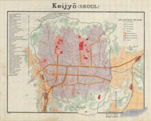
The primary source I have chosen is a map of Keijo published by the Japanese Tourist Bureau in 1913, three years after the Japanese took full control of Korea and produced in English for foreign tourists. As we can see from the map, the orange signifies the main thoroughfares of the city and red represents what the Japanese colonial government deems as important sites. The important sites are well connected by the roads and supported by a tramway system, which implies that the colonial government puts the interest of the coloniser above the colonised, as evident in urban planning. Subsequently, given that the source is produced for a Western tourist, it aims to showcase Japan’s modernity which is showcased in the map that the areas labelled in red are all structures built for Japanese interests like railway stations besides a few Korean palaces and mausoleums. Anything related to Korean culture or promoting Korean distinctiveness is blurred out in the purple background or branch streets as labelled on the map.
One thing that caught my interest was the labelling of green spaces on the map. The garden-city movement became a cornerstone for the development of colonial cities to produce green spaces for the colonising power to relax. {{ Peter Hall Cities of Tomorrow: An Intellectual History of Urban Planning and Design since 1880 (2014 4th ed.), Ch 4 “The City in the Garden }} Within the city boundaries of Keijo, green spaces surround the neighbourhoods and all the government-associated buildings have an abundance of green space near them. This is to showcase the absence of chaos to imply power and dominance. {{ Henry, Todd A. Assimilating Seoul: Japanese Rule and the Politics of Public Space in Colonial Korea, 1910–1945 (2014) }} This is a practice inherited from the British in their colonial city planning as showcased in Robert Home’s book Of Planting and Planning. [[ Home, Robert K. Of Planting and Planning: The Making of British Colonial Cities (1996) ]].
The findings of the map are backed up by Henry’s argument that although the city-planning of Keijo was intended to integrate the Koreans as loyal Japanese subjects through Japanification, numerous factors, including the lack of funding, war and the failure of Japanese economic policy ensured the gap between Koreans and Japanese settlers persisted and that little was done in improving the housing conditions of over 50% of Koreans living in poverty. [[ Henry, Todd A. Assimilating Seoul: Japanese Rule and the Politics of Public Space in Colonial Korea, 1910–1945 (2014) ]]. Subsequently, the town planning committees were overwhelmingly dominated by Japanese settlers and the lack of organisation of the funding system implies that Keijo was hard to become a reality for the Japanese city planners in achieving their ultimate plan in promoting their own imperial urbanism.