Imperial Tourism: A Comparison of Japanese Postcards of Colonial Korea

Spatial politics were central to the maintenance of Japan’s imperial empire.[1] A historical examination of tourism allows for analysis of how territory and geographical space were stabilised in the imagination of the Japanese public during the early 20th century. This blog post will explore the potential for understanding postcards as representative of historical mobility across this geographical space, both imagined and real. It will demonstrate this through comparing Japanese depictions of Korea through picture postcards produced in the colonial period. The arguments and ideas put forward in this post will form the basis of a longer analytical essay, and thus will aim to introduce the topic, highlighting potential areas for further development and synthesis.

“[Postcards] seem like shards of flash-frozen reality compacted into two dimensions, putative proof of having been there and seen that. They move over various forms of distance and time, while carrying with them ephemeral yet precious moments or sights to be appreciated, and then possibly forgotten.”[2]

There is a tendency in historical academia to treat postcards straightforwardly as either merely an embellished form of communication or simply a visual record, in much the same way as historical photographs. Whilst postcards do provide a valuable pictorial insight into the past, Hyung Gu Lynn argues that frequently scholars focus on the “aesthetic elements of the image” of postcards and neglect the socio-political context which an examination of their creation, distribution, and reception can allude to.[3] I argue that postcards inhibit both a sense of traversing space and traversing time. The sender of the postcard has travelled to an ‘unfamiliar’ space in order to purchase and post it back home. This is implicit in the meaning taken from the physical postcard itself, but also in the spatial imaginary it creates of the places photographed; thus the postcard has traversed space. Likewise, due to the nature of the postal service there is a passing of time between the act of the sender posting the card and it being received at its intended location; thus the postcard has traversed time. As Lynn states: “the postcard allowed for a journey into the afterglow of the recent past.”[4]

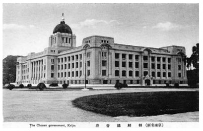
With this understanding, I will now compare three postcards of colonial Korea that, when analysed together, present a narrative of Japanese rule that emphasises colonial modernity. They are taken from the collection “The Views of Keijo.” Originally a 32 postcard set from the 1940s, only 29 of the postcards survive today.[5] The three postcards below all depict colonial Korea, but in dramatically different lights. Lynn argues that known changes to the urban landscape helps to place postcards (that often go undated) in time.[6] For example, the Government General Building in Seoul, Korea, was the subject of many postcards following its construction in 1926, as can be seen in the postcard below:
[7]

This postcard emphasises the modern architecture of the Government General Building, which sits on the previous site of the Korean Gyeongbok Palace. The demolition of valuable Korean historical and geomantic sites was a key facet of the Japanese occupation. In particular, new and modern Japanese buildings were located strategically and purposefully on old Korean sites. Part of the previous site was often left in ruins alongside the colonial site to demonstrate Japanese superiority.[8] These archaeological areas were then constructed into tourist spots, allowing the Japanese to select a specific representation of premodern Korean culture and civilisation to show the wider public.[9] The second postcard demonstrates this, depicting Gyeonghoeru Palace Hall:
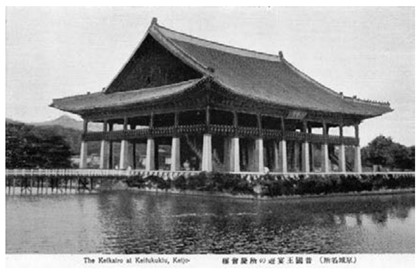
[10]

In the picturing of these two locations in the format of postcards, Japanese forces could demonstrate to the wider Japanese, Korean, and international public their colonial strength and achievements, as well as transforming premodern Korea into a voyeuristic object rather than a lived reality. Combined, this created colonial Seoul as a desirable tourist destination.

In contrast, the third postcard shows the Korean neighbourhood located outside Seoul’s East Gate:

[11]

Postcards such as this, which displayed the thatched roofs of a Korean neighbourhood, helped to reassert a discourse of progress, or lack thereof, through comparison of these spaces with ‘modern’ Japanese buildings.[12] According to these postcards, which were placed alongside one another in a collection, modernity is presented as a result of colonial rule. This narrative implies the upward development of Japanese innovation in comparison to the illustrations of Korean society as in stasis.[13] Furthermore, the Korean people pictured in the postcards become themselves the object of touristic voyeurism and attraction.[14]

“This set of postcards nicely represents three themes typically encountered by Japanese visitors to Korea around 1940, namely examples of modernity introduced by the Japanese, evidence of Japanese efforts to preserve examples of Korea’s “once advanced civilization,” and evidence of the still primitive contemporary native culture.”[15]

Moreover, Lynn argues that colonial postcards “helped portray the colony as a place that was desirable because of its distance, its picture postcard exoticism.”[16] Through postcards, the imagined space of colonial Korea became closer to the Japanese metropole centre, and movement between the two was implied as easily achieved through modern technologies such as ship, rail, and post. At the same time, these postcards painted Korea as consisting of people culturally different (read: backwards) compared to the Japanese people receiving the cards at home.

There are several potential analytical areas around historical postcards which, if developed, would provide further insight into how they are representative of spatial mobility. For instance, the majority of postcards in surviving archival records are cards that remained unsent, likely being donated as a collection.[17] This speaks to the purpose of the cards as beyond simply stationary or for communicative means, suggesting they were tokens worth collecting and preserving. This, however, begs the question; is there more value to those historical postcards which were posted? In terms of examining their mobility, does the act of the postcard itself physically crossing geographical distance (and their rarity now) make it more valuable of study than those which were simply bought and collected? Such questions provide a useful starting point for further academic investigation of the topic.


[1] MacDonald, Kate (2017) Placing Empire: Travel and the Social Imagination in Imperial Japan, Oakland: University of California Press, p. 2

[2] Hyung Gu Lynn (2007) ‘Moving Pictures: Postcards of Colonial Korea,’ IIAS Newsletter, 44: 8

[3] Ibid, p. 8

[4] Ibid, p. 8

[5] Ruoff, Kenneth J. (2010) ‘Touring Korea,’ in Imperial Japan at Its Zenith: The Wartime Celebration of the Empire’s 2,600th Anniversary, Cornell University Press, p. 109

[6] Lynn (2007) p. 8

[7] The Government General Building in Seoul, taken from the collection “The Views of Keijo,” as in Ruoff, Kenneth J. (2010) ‘Touring Korea,’ in Imperial Japan at Its Zenith: The Wartime Celebration of the Empire’s 2,600th Anniversary, Cornell University Press, p. 110

[8] Yoon Hong-Key (1988) ‘Iconographic Warfare and the Geomantic Landscape of Seoul,’ in The Culture of Fengshui in Korea: An Exploration of East Asian Geomancy, Lexington Books, p. 281

[9] Ruoff (2010) p. 109

[10] Gyeonghoeru Palace Hall, taken from the collection “The Views of Keijo,” as in Ruoff, Kenneth J. (2010) ‘Touring Korea,’ in Imperial Japan at Its Zenith: The Wartime Celebration of the Empire’s 2,600th Anniversary, Cornell University Press, p. 110

[11] Korean residential neighbourhood in colonial-era Seoul, taken from the collection “The Views of Keijo,” as in Ruoff, Kenneth J. (2010) ‘Touring Korea,’ in Imperial Japan at Its Zenith: The Wartime Celebration of the Empire’s 2,600th Anniversary, Cornell University Press, p. 111

[12] Lynn (2007) p. 9

[13] Ibid, p. 9

[14] Ruoff (2010) p. 111

[15] Ibid, p. 111

[16] Lynn (2007) p. 9

[17] Ibid, p. 8
Case Studies in World Fair Spatial Configurations

An examination of world fairs of the late 19th and early 20th centuries through a spatial historical lens provides a nuanced perspective on the overlapping cultural and international relations amongst nations at these exhibitions. This blog post will understand these fairs as “networks of exchange” rather than considering each exhibition in isolation.[1] Debra Hanson argues that the fairs, such as the 1851 Great Exhibition in London, initiated a new awareness within the “Western worldview” of the “transnational connections” amongst peoples, cultures, and nations.[2] I argue that this can be further understood through examining the spatial relations between different displays at these events, and in recognising how these relate to the global/local discourse.

David Raizman and Ethan Robey contend that the ‘language’ of material items holds political meaning. Material objects were judged by visitors in comparative terms between different nations and cultures, and politics and nationalistic rhetoric were intertwined with material objects in these fairs. Behind the unified image of peaceful competition presented at these world fairs, Raizman and Robey identify tensions and struggles between different participants, often due to their colonial status. A sort of contradiction can be identified here between image presented and reality:

“…economic competition among participant nations extended outward to supplies of raw materials and workers, and inexorably to colonialism, underpinned by the same military hardware so admired in the exhibition halls.”[3]

Raizman and Robey identify that often national histories were presented through specific narratives in the displays to help define and construct national pride.[4] We can thus identify an irony between many of the displays at these fairs. Whilst the displays of Western nations would present their colonial military ‘might’ in line with developments in technological modernity in the 19th century, the displays of Eastern or Southern (read: colonised) nations would be contrasted to these as a consumable commodity.[5] Nationalisms were communicated through the material objects on display and moulded and shaped in line with these narratives. The spatial relations amongst and between the displays played a part in this, as well as the guidebooks provided to supplement the displays and ensure the visitor followed the set path as they navigated the fair.[6] This defined the exhibitor’s position in relation to the host nation, as well as the observer’s position in relation to the displays and their original imagined locations.

A key example of how the spatial relations of the fairs constructed national narratives is in the 1893 Chicago Exposition. Structured as a classical White City, the buildings of the exposition were arranged in a centre and a periphery, with the Midway Plaisance leading away from the principal buildings. Hanson describes this lay out as a form of “spatial segregation,” as the further away one ventured from the central area the less ‘civilised’ the nations of display were presented to be.[9] Thus, the exhibition constructed a sliding scale of civilisational progress as physically represented by the Midway Plaisance, creating in line with this for the visitors a clear sense of the cultural global centre and periphery in actuality.

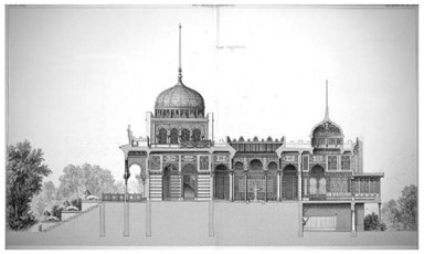
A further example of how the narratives of the displays were moulded by colonial influences can be seen in the Tunisian display at the Paris Exposition in 1867. Designed by French architect Alfred Chapon, the ‘Bardo of the Bey’ structure aimed to imitate Ahmed Bey’s summer palace:

[7]

The building adopted past styles and adapted them to contemporary (European) tastes, engaging with the present but preserving practices of the past. The interpretative narrative around the ‘Bardo of the Bey’ is divided. Hanson argues that the structure demonstrates Western management of the East, but for other scholars, it represents cultural negotiation and a physical symbol of hybridity.[8] However, colonial influences were intrinsically bound up in the structure’s creation. The “networks of exchange” occurring at these world fairs thus reflect the orientalist attitudes apparent in their spatial configurations.

Participation in the fairs often led to a construction of a careful, nuanced national past, in order to preserve national unity and political stability. Susan R. Fernsebner explores how a specific national image of “China” was presented by Chinese “expositional managers” (made up of Chinese elites) at various international expositions between 1904-1915.[10] How these elites presented ‘China’ tells us about their own ideas about Chinese nationalism at the time, and highlights the changes to the domestic Chinese political structure in the period. Fernsebner argues that the Nanyang Exposition of 1910 was used to mobilize people in the name of economic nationalism:

“In staging this exposition, Managing Director Chen Qi and his fellow organizers sought to stage a new kind of event for a mass audience in China, one that would help to shape a disciplined population to serve its nation… Organizers framed the ex-position as a studied inventory of the nation’s goods, both for domestic consumption amid foreign competition and export promotion, while placing a growing emphasis on science and industrial production.”[11]

Thus, the exhibitions at Nanyang served a dual purpose: the experience of visiting was painted as a national event to promote economic development, through and in combination with the social indoctrination of Chinese people viewing the displays.[12] Although less to do with the spatial configurations of the displays themselves, this example demonstrates how narrative of nationalism and modernity can be represented physically through material items (such as Raizman and Robey contested earlier on in this post), and how navigation of the physical exposition space affected the visitor phenomenologically.


[1] Raizman, David & Robey, Ethan (2017) ‘Introduction’ in Expanding Nationalisms at World’s Fairs: Identity, Diversity, and Exchange, 1851-1915. Routledge, p. 7

[2] Hanson, Debra (2017) ‘East meets West: Re-presenting the Arab-Islamic world at the nineteenth-century world’s fairs,’ in Raizman, David & Robey, Ethan (eds.), Expanding Nationalisms at World’s Fairs: Identity, Diversity, and Exchange, 1851-1915. Routledge, p. 15

[3] Raizman & Robey (2017) pp. 5-6

[4] Ibid, p. 11

[5] Hanson (2017) p. 15

[6] Ibid, p. 16

[7] Chapon, Alfred (1867) ‘Bardo,’ Pavilion of the Bey of Tunis, Exposition Universelle, Paris, sectional print. Reproduced from Revue generale de l’architecture et des travaux publics, vol. 27 (Paris: Paris Ducher 1869), pp. 35-36

[8] Hanson (2017) p. 27

[9] Ibid, p. 28

[10] Fernsebner, Susan R. (2017) ‘When the local is global: Case studies in early twentieth-century Chinese exposition projects,’ in Raizman, David & Robey, Ethan (eds.), Expanding Nationalisms at World’s Fairs: Identity, Diversity, and Exchange, 1851-1915. Routledge, p. 173

[11] Ibid, p. 178

[12] Ibid, p. 179

Shanghai’s ‘Underworld’: Considering Crime Spatially

When investigating the history of crime, whether on an institutional or ‘organised’ level, or simply petty thievery, we encounter many oppositions and binaries. Crime exists in opposition to an imposed order. It implies a nonadherence to a set rule. Frederic Wakeman’s article on policing Shanghai in the 1920s and 30s explores the various forces seeking to instil order in Shanghai, which contributed towards its development as an urban municipality.[1] Throughout his article there runs an analytical undercurrent about how crime (considering it as representing an opposition to a desired order) affected urban administrative developments. This in turn influenced Shanghai’s development as a demarcated municipality. In this blog post, I will reject the notion of crime as in complete opposition to policed urban order in Shanghai in the 1920s. I argue that these criminal networks were bound up in the governing processes of Shanghai, both formally and informally. We can better understand the spatial ordering of urban Shanghai, and how this evolved throughout the early- to mid-20th century, by analysing this complex relationship between crime, order, and authority.

The language used when discussing crime in an urban context often constructs a separate location for its occurrence. For instance, presenting the ‘underworld’ of a city, which exists alongside the regular city, provides an imaginary for where crime takes place that is useful to maintain order. Out of sight and out of mind, as it were. This separation allows residents to feel safe in the ordered ‘above-ground’ side of the city, separated from the ‘underworld’ of criminal activities and morally questionable behaviour. Concerning the ‘underworld’ of Shanghai, Wakeman explains:

“Virtually all of these underworld elements belonged to small bands of gangsters called dang or hui that were ruled over by a massive criminal confederation and secret society, originally organized by Yangzi River boatmen, called the “Green Gang” (Qingbang).”[2]

 Wakeman argues that because the Qingbang kept the criminal world of Shanghai ‘in order,’ their activities and existence were tolerated by the International Settlement, French, and Chinese police forces. Many police officers and detectives were associated with the Qingbang or drawn from its membership, as this association was key to performing arrests needed in order to supplement their regular salaries.[3] Already we can observe a complexity in that the Qingbang were instilling an informal form of order within their pursuits as criminals and racketeers. There is order in the coordination of their criminal activities, and thus the notion that crime exists in binary opposition to lawfulness is no longer applicable. Furthermore, we can understand this directly through the influence of crime on Shanghai’s evolution into a municipality.

The power struggle between the central Nanjing government and municipalities establishing their own identities played out through the police and urban order mediums.[4] In Shanghai, both Wakeman and Brian Martin connect these tensions to complex criminal networks through locating illegal activities in the French Concession area. Captain Fiori of the French Concessionary Police (FCP) protected the economic power of Qingbang undertakings, such as in gambling or opium rackets. First, in the early 1920s through instating Huang Jinrong as chief detective, and then in the later 1920s through using Du Yuesheng’s influence to maintain the Concession’s security in the face of national political unrest.[5] Martin argues that the FCP tolerated Du’s racketeering in return for Qingbang aid in maintaining order within the Concession:

“The close cooperation between the French police and Du Yuesheng’s gangsters was officially acknowledged in 1928 by the acting Consul General Meyrier in a dispatch to the French Minister in Beiping. It is probable that the French used the gangster bosses as their intermediaries in establishing contacts with the GMD’s NRA [Guomindang’s National Revolutionary Army], an important element in their strategy to maintain the security of the Concession during the first four months of 1927.”[6]

Through this intertwining of authority, the Qingbang’s crimes become relegated in the public’s imagination to another ‘criminal world,’ not visible to and unaffecting of their safety within the Concession area. In turn, this criminal ‘underworld’ is ordered by the spatial limitations of the collusion that resulted from the complicated relationship between these criminals and the police. An understanding of crime in a binary as solely in opposition to official authority prevents investigation of how illegal activities affected urban administrative developments in Shanghai, which directly contributed to its demarcation as a municipality. Where we historically locate crime, and how visibly it appeared, is affected by recognising these informal expressions of authority in combination with formal institutionalised authority.


[1] Frederic Wakeman Jr. (1988) ‘Policing Modern Shanghai,’ The China Quarterly, 115: 409

[2] Wakeman (1988) p. 414; William T. Rowe (1982) ‘The Qingbang and collaboration under the Japanese, 1939-1945: materials in the Wuhan Municipal Archives,’ Modern China, 8(4): 493-94

[3] Wakeman (1988) p. 415

[4] Ibid, p. 425-6

[5] Wakeman (1988) p. 415; Martin, Brian G. (2020) The Shanghai Green Gang: Politics and Organized Crime, 1919-1937, Berkeley: University of California Press, p. 115

[6] Martin (2020) p. 115

Agency and Representation in Hanoi’s Public Space

Newspaper articles are invaluable sources through which historians can gain a sense of popular opinion and perceptions. However, due to their commercial nature, they can also often sensationalise these opinions and present them in an affected light. Laura Victoir and Victor Zatsepine examine the perceptions of public space in Hanoi in the French colonial period through the writings in the newspaper l’Avenir du Tonkin. In this blog post I will examine their investigation of perceptions of Hanoi’s public spaces, and argue that the commentary in their chapter presents a discourse that demonstrates only the coloniser’s perspective, denying the agency of the Vietnamese people who were also living there and experiencing these spaces.


Colonial urban commentary made up a large part of the writings in l’Avenir du Tonkin, the first French language newspaper of the European communities in Hanoi. The newspaper was used by editors to “voice criticism and confidence in the growing city and its rapidly developing landscape.”[1] Victoir and Zatsepine’s chapter aims to explore the various discourses about Hanoi’s public spaces as presented in the colonial news media. Through this, they discuss attempts made by French colonial authorities to respond to Hanoi’s urban practices and transform it into a modern ‘desirable’ city. This was juxtaposed with the portrayal of Hanoi’s streets as dangerous and unsanitary in the more sensationalist newspaper pieces. These streets were portrayed through writings in l’Avenir as “spaces in which vigilance was ever-required,” and the dangers outlined by the editors were “given a specific and thus avoidable location – the public spaces of the city.”[2] For example, the editor responds to proposed plans for rubbish disposal and sewage management in 1888:


             “This contract, if given to the right people, will be a real benefit to the population, because a number of quarters have become, due to Vietnamese carelessness and the dirtiness, hotbeds of infection presenting grave dangers in a time of epidemics. [The large area between the route du Hue, the Camp des Lettrés, and the palace of the kinh luoc] serves as a depository for coolies paid to empty the boxes which serve as tinettes; when the deposits are full enough, swarms of women come from the countryside to take them away in the small pails and baskets that we know. People often bury their dead [there]. As there is no decree forbidding inhumations in the very heart of the city, the police can do nothing.”[3]


Although in response to plans for a sanitation contract, there is an underlying commentary concerning the coloniser’s perception of Vietnamese people as lacking hygiene in this excerpt, specifically regarding how and where they buried their dead. Victoir and Zatsepine fail to acknowledge or investigate the actuality of Vietnamese death practices in their analysis of excerpts such as this, or explore why these practices may have not correlated with colonial sanitation attempts. Thus, we are forced to read against the grain of their chapter to gain any semblance of Vietnamese spatial practices, and in this the colonised peoples are relegated solely to their ‘unsanitary’ representations in this colonial newspaper.


Michael G. Vann similarly investigates colonial sanitation attempts in Hanoi during the colonial period. He argues that in attempting to modernise the urban built environment of Hanoi by building sewers, the French created a prime breeding environment for rats, which carried diseases such as the bubonic plague.[4] Due to the uneven distribution of sanitation infrastructure which had privileged the European areas, the overwhelming rat infestations became an almost exclusively European issue. Vann allows for Vietnamese agency increasingly more so than Victoir and Zatsepine do, detailing how Vietnamese sewer workers and rat catchers attempted to form collective labour action against their French employers.[5] Ultimately, however, colonial efforts at modernisation became tied to the spread of disease in urban Vietnam, and the colonisers became deeply dependent on employing the colonised people as rat catchers.


Alongside the discourse that Hanoi’s public spaces were dangerous or repulsive, there was simultaneously emphasis in this newspaper literature that Hanoi was to be the location for the materialisation of colonial urban desires.[6] In order to achieve these civilising aims, French colonial powers would have emphasised the oppositionality of Vietnamese spatial practices in the popular press which they exerted influence over, l’Avenir being included in this. Nonetheless, as the city evolved in the later colonial period, and the French Concession expanded, how both the colonised peoples and the colonising force navigated Hanoi’s public spaces became more complex. It is important to account for this complexity and for the interplay of actors when discussing colonial public space in Hanoi. Giving agency to the Vietnamese forcibly navigating the colonial in histories of the urban environment is one way of attempting this.


[1] Victoir, Laura & Zatsepine, Victor (2013) Harbin to Hanoi: The Colonial Built Environment in Asia, 1840 to 1940, p. 207

[2] Ibid, p. 209

[3] l’Avenir du Tonkin, June 30 (1888)

[4] Vann, Michael G. (2003) ‘Of Rats, Rice, and Race: The Great Hanoi Rat Massacre, an Episode in French Colonial History,’ French Colonial History, 4: 194

[5] Ibid, p. 197

[6] Victoir & Zatsepine (2013) p. 219

The American Clubhouse and Identity in the Philippines

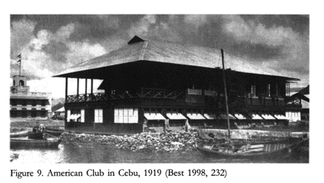
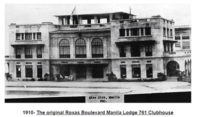
In 1898, after U.S. forces had invaded during the Spanish-American War, the Philippines was ceded as a concessionary territory to the U.S. The American colonial period lasted until 1946. During this era, there was an increase in immigration to the Philippines, as U.S. forces attempted to “create a country and a people in the American image”.[1] Kiyoko Yamaguchi examines the Philippine architecture built under this influence, and argues that buildings constructed during this time labelled as ‘American’ were not built by U.S. colonisers, but by the elite urban Filipinos in what they interpreted to be the ‘American’ style.[2] In actuality, immigrants from America isolated themselves and their community through social clubs and viewed their residence there as temporary.[3] This post will examine how these colonial residents became uniformly ‘American’ by examining the spaces, both perceived and physical, in and around exclusive social club houses in the Philippines.

[4]

[5]

Much of the history written about the Philippines relies on oral and biographical histories, mainly originating from the memories of  American immigrants who grew up there during the colonial period. Consequently, narratives of the American lifestyle during the 1920s and 1930s in particular are often filled with idealistic notions of “serenity”, and take the social segregation of Filipinos and Americans as the norm.[6] Examine this 1939 excerpt by Walter Robb:

“Filipinos were accustomed enough to dealing with strangers… On their part the Americans displayed a remarkable adaptability; without destroying what existed, they set to building upon it and to patterning for the Philippines a government of the American type that was effective against a Latin background…”[7]

Or view these quotes from Merv Simpson, manager at the Corinthian Plaza in Manila, talking about his life in the Philippines in the 1930s:

“It was a peaceful life. We had parties, or at least my parents had parties, but nobody got bombed, at least as I can remember… Before the war we didn’t play with Filipino kids or associate with them very much. It wasn’t any snobbish thing; we just didn’t do it.”

“It was pretty sheltered. We went to the American School. No Filipino kids [but some] mestizos… I’d ask my mother – I’d want to go to the Polo Club, it would be Saturday morning – so she’d give me a peso. That was big dough back then. I’d take a taxi out there… At the Polo Club we used to swim, badminton, bowling, tennis – it was a nice life. We would just sign [for the bill]…”[8]

Recorded in this nature, the colonial spaces of the Philippines become subject to consumption through sentimental regard, which Vicente L. Rafael argues allows for a domestication of “what is seen as native and natural into aspects of the colonial, which is at once also national.”[9] He maintains that through these types of historical accounts, colonialism is invested with a sense of domesticity, allowing for the pervasiveness of Western gendered and racialized notions into the colonial experience.[10] Thus, the colonial experience recounted here simultaneously normalises and sentimentalises the racial divisions of the American period. One of the key ways in which this occurs is through mentions of the social clubs that American residents in the Philippines engaged in, but which Filipinos were barred from.

Yamaguchi recognises this, and through her discussions develops the idea of an ‘imagined America’ in the Philippines. She explores how the self-perception of U.S. citizens living in the Philippines evolved by analysing the exclusive social club houses set up by the colonial American community. Many of the Americans who arrived in the Philippines were second- or third-generation European immigrants to the U.S. themselves, and so their American identities became strengthened by the role they played in these colonial communities.[11]

“The Americans were not Filipinized by living in the Philippines; they became more self-consciously and assertively American, a fact most apparent in the club premises, where they confined themselves in particular buildings.” [12]

Yamaguchi argues that these exclusive clubhouses prescribed an American “uniformity” to the blurred identities of these colonial residents.[13] The diversity of the cultural backgrounds of these Americans meant it was likely they would have never befriended one another if they had met in the U.S.. Because of their location in the Philippines, and through the sociality of the spaces offered through membership to these clubhouses (spaces which became the metaphorical petri dish for colonial politics), these differences faded in the face of attachment to a specific U.S. identity.[14] The spaces within the clubhouse also solidified other identities, namely, that of the Filipinos who they excluded. The Filipino residents in these areas were barred from membership despite the fact that many Filipino urban elites were often just as wealthy as their American counterparts.[15] This exclusion also sought to define the Filipino identity categorisation, vis-à-vis what was not considered American.

Thus, the architecture of this period reflects the nature of the changing social groups in the Philippines, and articulates Filipino elite ambitions and interpretations of ‘American-ness’. These social clubs allowed for the standardisation of the American imperial lifestyle and identity, whilst simultaneously sentimentalising a social hierarchy based on race.


[1] McCallus, Joseph P. (2010) The MacArthur Highway and Other Relics of American Empire in the Philippines, Potomac Books. (page number unavailable).

[2] Yamaguchi, Kiyoko. “The New ‘American’ Houses in the Colonial Philippines and the Rise of the Urban Filipino Elite.” Philippine Studies 54, no. 3 (January 1, 2006): p. 413-14

[3] Ibid, p. 447

[4] Best, Jonathan (1994) Philippine album: American era photographs 1900-1930, Makati: Bookmark, p. 232

[5] ‘Lodge History: The Manila Elks Lodge 761 in its 114th Year’, https://www.manilaelks.org/about-us/manila-elks-lodge-761/lodge-history/ [Accessed 28/10/21]

[6] McCallus (2010) (page number unavailable)

[7] Ibid (page number unavailable)

[8] Ibid (page number unavailable)

[9] Rafael, Vicente L. (2000) ‘Colonial Domesticity: Engendering Race at the Edge of Empire, 1899-1912,’ White love and other events in Filipino history, Durham, NC: Duke University Press (page number unavailable)

[10] Ibid (page number unavailable)

[11] Yamaguchi, (2006) p. 424-26

[12] Ibid, p. 426

[13] Ibid, p. 425

[14] Yamaguchi, (2006) p. 426; Rafael, (2000) p. 56

[15] Yamaguchi, (2006) p. 431


Bibliography

  • Best, Jonathan (1994) Philippine album: American era photographs 1900-1930, Makati: Bookmark
  • McCallus, Joseph P. (2010) The MacArthur Highway and Other Relics of American Empire in the Philippines, Potomac Books. (page numbers unavailable)*
  • Rafael, Vicente L. (2000) ‘Colonial Domesticity: Engendering Race at the Edge of Empire, 1899-1912,’ White love and other events in Filipino history, Durham, NC: Duke University Press (page numbers unavailable)**
  • Yamaguchi, Kiyoko. “The New ‘American’ Houses in the Colonial Philippines and the Rise of the Urban Filipino Elite.” Philippine Studies 54, no. 3 (January 1, 2006): 412–51
  • ‘Lodge History: The Manila Elks Lodge 761 in its 114th Year’, https://www.manilaelks.org/about-us/manila-elks-lodge-761/lodge-history/ [Accessed 28/10/21]

*Limited access available to book online due to lack of institutional access, quotes taken from ‘Look inside’ excerpt available on Amazon listing: https://www.amazon.co.uk/dp/B005CWJMFU/ref=dp-kindle-redirect?_encoding=UTF8&btkr=1 [Accessed 28/10/21]

**Limited access available to book online due to lack of institutional access, quotes taken from excerpt found through Project Muse: https://muse.jhu.edu/chapter/2618760 [Accessed 28/10/21]

Geomantic Warfare: The Japanese General Government Building in Seoul

Gyeongbok Palace was originally built in the 14th century as the centre of Joseon Dynastic rule in Seoul, Korea. The first king of Joseon constructed the palace as both physically and symbolically representative of the auspiciousness of his rule. This, in turn, bolstered the legitimacy of the dynastic change and helped to naturalise the movement of the capital from Kaesong to Seoul.[1] This process was deeply influenced by concepts of pungsu, or ‘geomancy’ in English; “traditional ideas and practices concerning the relationship of human beings with the surrounding environment.”[2] Geomantic ideals were utilised in order to emphasise the good geographic placement of Gyeongbok Palace and of the surrounding landscape to the people, which helped the ruling elites to solidify their power. Following the annexation of Korea in 1910, the Japanese defaced the Gyeongbok Palace site in an attempt to accentuate their own power and naturalise the authority of their colonial rule. Most importantly, they manipulated Korean geomantic ideals to reinforce this, and constructed their General Government Building on the palace grounds.[3] How they engaged in this ‘geomantic warfare’ is what I will explore in this post, making use of historical photographs to do so.

“The Japanese colonial government carefully examined the geomantically auspicious sites of Korea, and then ruined and occupied the sites by replacing Korean buildings with Shinto shrines or Japanese government buildings.”[4]

In The Culture of Fengshui in Korea, author Hong-Key Yoon employs the cultural-geographic approach of “reading landscape as a text like a book” to analyse the site of Gyeongbok Palace.[5] Yoon writes about the changes to this cultural site across the 20th century, and examines how ideologies and power relations were built into the meanings taken from these physical geographic changes. Geomantic interpretations were central to this, and Yoon argues these social constructions were used to artificially reinforce popular beliefs about specific landscapes.[6]

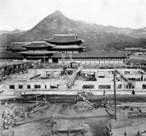
Archival photograph showing the construction of the Japanese General Government Building in front of Gyeongbok Palace.[7]

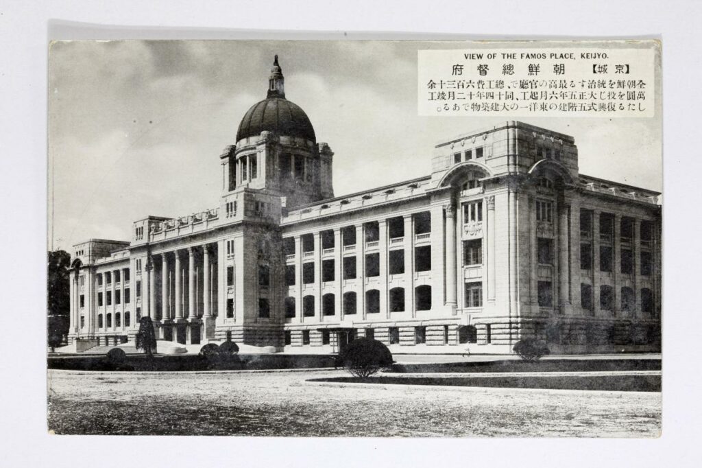
 The Japanese General Government Building in Seoul was built in 1926 by the Empire of Japan as the central administrative headquarters of their colonial rule over Korea. The building was constructed over the site of Gyeongbok Palace, widely renowned as one of Korea’s most auspicious and important cultural locations. Yoon explains how the Japanese used a method known as ‘palimpsest’ in order to naturalise their new colonial icons. This involves a deliberate comparison of a new “strong” icon against an old “weak” icon.[8] In the case of the Gyeongbok site, the Japanese did not completely replace the Palace with their own building.[9] Rather, they left part of the ruins in place to the back of their new building (an area which, according to geomantic interpretations, is unfavourable). The General Government Building towered over the Palace in both physical height and symbolic strength. This deliberate visual comparison of the two powers represented here had a clear interpretation: Japan was strong, Korea was weak.

Archival photograph of the former Japanese General Government building located in front of Gyeongbokgung Palace in central Seoul (source: Busan Museum).[10]

 The Japanese were said to have deliberately disrupted the geomancy of the Korean site in an attempt to legitimize their power and de-legitimize Korean nationalism. During the debate in the 1990s over whether the General Government Building should be demolished, there was a widespread public discourse that the building had been the leading weapon in a Japanese plot to deliberately block Korea’s national energy (as encapsulated in the Gyeongbok site).[11] This was proliferated by the discovery of “Japanese spikes” under the site of the building during the demolition process;

“These spikes were 20 to 25 centimetres in diameter and 4 to 8 metres in height, and they were tightly packed, about 60 centimetres apart from each other. (Dong-a Newspaper, 29 November 1996).”[12]

A photographic example of similar Japanese spikes supposedly found by activists between 1995 and 2001 in the Jirisan National Park.[13]

The spikes were driven into the ground supposedly as part of the building’s foundations but, in the mind of the Korean public, they were a purposeful attempt to suppress the “earth-energy” of Joseon’s finest palace.[14] Without the nationalistic geomantic interpretation of what these spikes represented, their findings would have otherwise been of little note to the Korean public. Although, it is important to note that whilst the argument that the Japanese purposefully constructed their General Government building in order to destroy the geomancy of Gyeongbok palace is widely accepted, the argument that Imperial Japan deliberately fixed these iron spikes into the ground as part of this remains controversial.[15] 

Yoon argues that geomancy was not the cause of this battle over the Gyeongbok landscape.[16] Rather, the geomantic interpretations taken from the actions of these two powers (and the buildings represented by them) were used and manipulated in order to achieve various political aims, and to legitimize and de-legitimize support for Imperial Japan in the Korean public mindset throughout the 20th century.


[1] Yoon, Hong-Key, ‘Ch15 Iconographic Warfare and the Geomantic Landscape of Seoul’, in The Culture of Fengshui in Korea: An Exploration of East Asian Geomancy, Lexington Books (1988): p. 283

[2] Han, Jung-san, “Japan in the Public Culture of South Korea, 1945-2000s: The Making and Remaking of Colonial Sites and Memories,” Japan Focus, Vol. 12, Issue 15, No. 2 (2014)

[3] Yoon, Hong-Key, ‘Ch15 Iconographic Warfare and the Geomantic Landscape of Seoul’, in The Culture of Fengshui in Korea: An Exploration of East Asian Geomancy, Lexington Books (1988): p. 277

[4] Ibid, p. 287

[5] Ibid, p. 304

[6] Yoon, Hong-Key, ‘Ch14 The Social Construction of Kaesong,’ in The Culture of Fengshui in Korea: An Exploration of East Asian Geomancy, Lexington Books (1988): pp. 241-42

[7] Booth, Anne, ‘Did It Really Help to be a Japanese Colony? East Asian Economic Performance in Historical Perspective’, Japan Focus, Vol. 5, Issue 5 (2007)

[8] Yoon, Hong-Key, ‘Ch15 Iconographic Warfare and the Geomantic Landscape of Seoul’, in The Culture of Fengshui in Korea: An Exploration of East Asian Geomancy, Lexington Books (1988): p. 281

[9] Han, Jung-san, “Japan in the Public Culture of South Korea, 1945-2000s: The Making and Remaking of Colonial Sites and Memories,” Japan Focus, Vol. 12, Issue 15, No. 2 (2014)

[10] Park, Yuna, ‘Controversy over architectural heritage from Japanese colonial era continues,’ The Korea Herald (Aug 10, 2020) http://www.koreaherald.com/view.php?ud=20200819000642 [Accessed 23/10/21]

[11] Han, Jung-san, “Japan in the Public Culture of South Korea, 1945-2000s: The Making and Remaking of Colonial Sites and Memories,” Japan Focus, Vol. 12, Issue 15, No. 2 (2014)

[12] Ibid

[13] Personal photograph from ‘Did the Colonial Japanese drive Spikes into Sacred Korean Mountains…?’ http://www.san-shin.org/Spikes-controversy.html [Accessed 23/10/21]

[14] Han, Jung-san, “Japan in the Public Culture of South Korea, 1945-2000s: The Making and Remaking of Colonial Sites and Memories,” Japan Focus, Vol. 12, Issue 15, No. 2 (2014)

[15] Ibid

[16] Yoon, Hong-Key, ‘Ch15 Iconographic Warfare and the Geomantic Landscape of Seoul’, in The Culture of Fengshui in Korea: An Exploration of East Asian Geomancy, Lexington Books (1988): p. 304


Bibliography

  • Booth, Anne, ‘Did It Really Help to be a Japanese Colony? East Asian Economic Performance in Historical Perspective’, Japan Focus, Vol. 5, Issue 5 (2007)
  • Han, Jung-san, “Japan in the Public Culture of South Korea, 1945-2000s: The Making and Remaking of Colonial Sites and Memories,” Japan Focus, Vol. 12, Issue 15, No. 2 (2014)
  • Park, Yuna, ‘Controversy over architectural heritage from Japanese colonial era continues,’ The Korea Herald (Aug 10, 2020) http://www.koreaherald.com/view.php?ud=20200819000642 [Accessed 23/10/21]
  • Yoon, Hong-Key, ‘Ch14 The Social Construction of Kaesong,’ in The Culture of Fengshui in Korea: An Exploration of East Asian Geomancy, Lexington Books (1988)
  • Yoon, Hong-Key, ‘Ch15 Iconographic Warfare and the Geomantic Landscape of Seoul’, in The Culture of Fengshui in Korea: An Exploration of East Asian Geomancy, Lexington Books (1988)
  • ‘Did the Colonial Japanese drive Spikes into Sacred Korean Mountains…?’ http://www.san-shin.org/Spikes-controversy.html [Accessed 23/10/21]

Badly Drawn Maps

Badly Drawn Maps and what they can teach us

What makes a good historical map? Do detail and accuracy outweigh aesthetics and simplicity? Alternatively, what makes a bad historical map? Plenty of contemporary pop culture articles find entertainment in examining strange historical maps, assuming their scientific inaccuracy is something comical. But within these ‘inaccuracies,’ can we find historical insight we might have otherwise overlooked? This is the essential question Martin Bruckner seeks to answer. Don’t dismiss a historical map based on assumptions of what makes a ‘good’ or ‘bad’ map, argues Bruckner, rather we should explore why these definitions exist in the first place.

When examining maps, we make various assumptions about the relations of the map: the territory itself as existing independently of the map, north/south being top to bottom, east/west being right to left, and so on.[1] The “old” method of understanding historical maps, according to Bruckner, suggests that ‘good’ maps have unmistakable meanings, and ideals like truth and error are conceptually presented through them. They are the products of empirical science.[2] The map is a representation of a place. Yet, from the 1990s, ‘place’ began to be thought about more broadly, and scholars began treating maps as “subjective representations of social locations and human activities.”[3] This understanding also treats maps as places themselves.

“In this view, maps are considered text-specific locales, or sites, shaped by a variety of contexts, ranging from the biography of the mapmaker to the geography of map production to the language of maps.”[4]

For Bruckner, however, our analytic approach to maps should go a step further than this text-based understanding. Historical maps are representations of places deeply endowed with sociality, being both man-made and “man-used.”[5] He argues for considering maps as products of social practice, shaped by all of the aspects that go into their creation; they are moulded by the engraver, painter, ink and paper suppliers just as much as the scholars and librarians who consume them.[6] Similarly, Matt Reeck views maps as “architecture of mind”. He argues they are a dynamic component of a historical process of commerce and settlement: “The advent of good maps is the advent of control over the land…”[7] For Reeck, mobility and movement of peoples is directly connected to cartography, and yet maps too often seek to standardize this; they aspire to “place places outside of time.”[8] Maps are social constructions, they push political agendas and represent societal attitudes. Their creation is often greatly influenced by power interests completely outside of the cartographic industry. Thus, can historical maps truly be deemed either ‘good’ or ‘bad’?


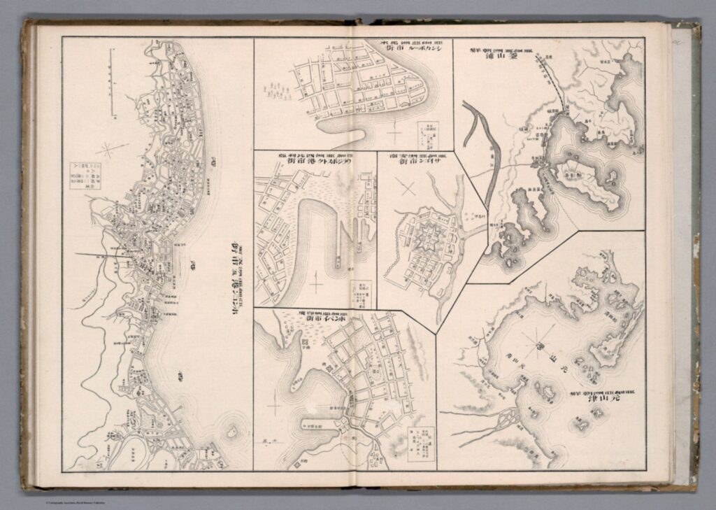
Taking Bruckner’s social approach, empirically ‘bad’ historical maps can now be considered useful and insightful in how they relate to issues other than physical geography. We can provide maps, seemingly objective creations, with historicity and time. Although developed in an American context, Bruckner’s approach can be equally applied to historical maps from East Asia. Examine this 1906 (Meiji 39) map by Japanese cartographer Yamane Akisato:


This atlas page shows 7 maps of various East Asian cities. Included (from left to right) are Hong Kong, Singapore, Vladivostok, Saigon, Bombay, Busan, and Wonsan. The maps show details of the city plan (roads, rivers, railways, etc.), the coastal outline, and major buildings, such as military stations. They are drawn in a simplistic black and white line drawing, which allows for a focus on the layout and structure of the cities and makes them easy to compare. These city maps were published in the atlas in between more detailed and coloured maps and illustrations, and the atlas includes text in both Japanese and Chinese. You may notice that these simple drawings are particularly ‘inaccurate’, or, in the very least, lacking detail. The coastline in the top-centre city (which I assume is meant to be Singapore, although it is difficult to tell) is comically simple, as if included in the compilation as an afterthought. In comparison, the coastlines of Busan and Wonsan on the right are drawn with more extreme detail. Deer Island in Busan’s Bay is especially noticeable, and details of smaller islands and water depth is even included. Although the map of Hong Kong (located far left) is denser, several of the streets are mislabelled in comparison to the reality of their positionality to one another. This strange picking-and-choosing of what details to include and what details to leave out by Akisato, the cartographer, is what makes this map so fascinating. If we now apply Bruckner’s social approach to analysing this map, it opens up the potential for historical interpretation and insight to be gained from it.


Drawn from the Japanese perspective in 1906 (Meiji 39), the map tells us how Japanese citizens might have seen and understood the world, and the importance of other cities in East Asia in comparison to their own. Placing these maps within the historical context of Japan’s activities in 1906, it makes sense for the map of Busan to detail so clearly the coastline and water depth around the city. Busan was a treaty-port which the Japanese held particular influence over around the time this map was published, and in which a strong Japanese presence had existed since the 15th century. Busan was the foothold through which Japanese forces established their control over the Korean peninsula prior to annexation in 1910.[9] It is likely Akisato may have visited Busan directly during his life, although not much is known about the cartographer himself and this is merely hypothetical. Regardless, as a Japanese citizen Akisato would have had, at the very least, more readily available access to information about Busan than to information about Singapore, for example, which was under British colonial control at the time.

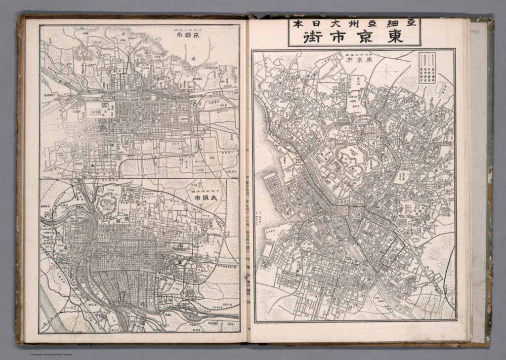
More acutely, these maps tell us how Akisato thought these cities should be presented in his atlas, and thus to those learning from his atlas. This highlights what he might have thought relevant, or in this case, not relevant, to be teaching other Japanese consumers about the wider world and about other cities across Asia, especially in comparison to Japan’s own major cities. There is a similar insert page in the same atlas that depicts Tokyo and its surrounding areas, Kyoto, and Osaka. These maps, meant to act as educational tools in the same way as the first 7 we examined above, are extremely dense, showing the grid block layouts of these cities in exact detail.


Considering the Japanese colonial context under which these maps were created once again, we can invoke Bruckner’s social approach to understand why these Japanese cities are presented more carefully. In the book How to Lie with Maps, Mark Monmonier argues that nations often enhance map features that support their point of view on the world and leave out details on the features that sit contrary to this.[10] Is this what is occurring here with Akisato’s atlas? Potentially, but further insight into this would require more research on his career and the publishing details of the atlas itself. At any rate, these maps are shaped deeply by Japanese colonialism and the power relations at play in East Asia in the early 1900s.

J. B. Harley maintains that historians of cartography often simply accept the cartographer’s suggestions of what historical maps are meant to represent, and advocates for greater scrutinization of maps as forms of knowledge creation. [11] The relationship between representation and reality contained within maps affects our relations to and perceptions of the material world, which is all the more pertinent considering a historical context far prior to the information technology era. These historical Japanese maps of various East Asian cities provide a good example of how we can scrutinize as Harley suggests, and they offer a great entry point for further research in this area.


[1] Searle, John. R., ‘Chapter 4: The Map and the Territory,’ in Wuppuluri, S. & Doria, F. A. (eds.) The Map and the Territory, Springer International Publishing (2018): p. 72

[2] Bruckner, Martin, ‘Good Maps, Bad Maps; or, How to Interpret A Map of Pennsylvania,’ Pennsylvania Legacies, Vol. 9, No. 2 (November 2009): p. 40

[3] Ibid, p. 40

[4] Ibid, p. 40

[5] Ibid, p. 40

[6] Ibid, p. 41

[7] Reeck, Matt, ‘A Brief History of the Colonial Map in India – or, the Map as Architecture of Mind,’ Conjunctions, No. 68, Inside Out: Architectures of Experience (2017): p. 185

[8] Ibid, p. 185

[9] Kang, Sungwoo, ‘Colonising the Port City Pusan in Korea: A Study of the Process of Japanese Domination in the Urban Space of Pusan During the Open-Port Period (1876-1910)’, Ph.D. Dissertation, University of Oxford (2012): p. 86

[10] Monmonier, Mark S., How to Lie with Maps, 3rd ed., Chicago: University of Chicago Press (2018): p. 132

[11] Harley, J. B., ‘Deconstructing the map,’ Passages, University of Michigan Library https://quod.lib.umich.edu/p/passages/4761530.0003.008/–deconstructing-the-map?rgn=main;view=fulltext [Accessed 09/10/21]


Primary Sources:

Akisato, Yamane, “Buson, Wonson, Vladivostok, Saigon, Bombay, Hong Kong.” from New Atlas & Geography Table (Bankoku chin chizu chiri tokeihyo), Nakamura: Shobido, Meiji 39 (1906) https://www.davidrumsey.com/luna/servlet/detail/RUMSEY~8~1~313791~90082699:Buson–Wonson–Vladivostok–Saigon-?sort=Pub_List_No_InitialSort&qvq=q:vladivostok;sort:Pub_List_No_InitialSort;lc:RUMSEY~8~1&mi=11&trs=12# [Accessed 08/10/21]

Akisato, Yamane, “Tokyo and environs, Kyoto, Osaka.” from New Atlas & Geography Table (Bankoku chin chizu chiri tokeihyo), Nakamura: Shobido, Meiji 39 (1906) https://www.davidrumsey.com/luna/servlet/detail/RUMSEY~8~1~313790~90082700:Tokyo-and-environs–Kyoto–Osaka?sort=Pub_List_No_InitialSort&qvq=q:author%3D%22Akisato%2C%20Yamane%22;sort:Pub_List_No_InitialSort;lc:RUMSEY~8~1&mi=21&trs=36 [Accessed 10/10/21]

A Comparison of Foreign Settlements in Korea: Busan and Incheon

Busan is located on the south-east coast of Korea, a geographically attractive port and trading centre in close proximity to Japan. This post will aim to compare the Japanese settlement at Busan with the general foreign settlements in Incheon (the port servicing Seoul), and understand the complex relationships between the Korean and foreign populations in each area. Using primary sources taken from the North China Herald, among others, this post will analyse the subtle exploitation of Koreans by the Japanese settlement residents in Busan, and why Japanese presence differed from the presence of other foreign residents.

[Note on place names: Busan is often Romanised as both Fusan and Pusan. Incheon was formerly known as Jemulpo, often Romanised as Chemulpo.]


The Japan Gazette extracts the following letter from the Choya Shimbun; it was sent to the latter paper by the Okura Trading Company in Fusan; Corea: The Japanese Settlement in Fusan is not very extensive, but it is almost entirely a business Settlement. The streets are divided into two, one is named Bentendori(弁天) and the other Honcho-dori (本町). Many godowns are built in a line on the shore side of the Settlement, and shops are built behind every godown. The Kanri-kencho, or local Japanese office, is situated in Honcho-dori, which is on a beautiful position, facing the harbour of Fusan. Fine pine forests are on the left and right sides. Foreign, home, and police affairs, are all transacted at the Kanrikencho, where, however, the officials have not any very great tax upon their time. Last spring the river in the Settlement was dredged and cleaned out, and the streets were also repaired by order of Kondo, Superintendent of the Japanese Police. A small hill lies on the coast, on which he wishes to make a garden for our residents, and the work has been commenced. Omura, a large village, lies at a distance of 30 Corean miles from the Japanese Settlement.

North China Herald, 28 July 1877. [emphasis added][1]

Here, the Japanese settlement at Busan is explained as “entirely a business settlement”. Following the Treaty of Kanghwa in 1876 (which brought the ‘open-port period’ in Korea) the Japanese Government sought to stabilize and expand its settlement in the port-city Busan, which has existed since approximately the 15th century. The source above, being written in the year following the treaty, depicts the geography of Busan and shows the early Japanese domination of the landscape, and the potential for expansion of this.

As a result of several political mandates in favour of Japanese territoriality, the political centre of the town moved from Tongnae (where the Korean commercial market area was) to the growing area of the Waegwan (where the existing Japanese settlement and markets based within The Japan House were). Sungwoo Kang argues that Japanese migration occurred more for commercial interests than political, as is shown by the popularity of Busan over Seoul as a migration destination prior to Korean annexation in 1910.[2] The fishing village of Incheon had been chosen as the corresponding open port for Seoul, despite its slight geographical unattractiveness. Due to the creation of foreign settlements around this village in the same manner as in Busan (but with other foreign powers present more so), it developed into a modern city port by the time of annexation.

Because of the existing Japanese settlement in Busan at The Japan House, the town already sat at the centre of existing trading structures both domestically and internationally. With the opening of the ports after 1876, its central trading position was reinforced, and the trading structures greatly influenced by the expanding Japanese presence. By 1909, the Japanese population outnumbered the Korean population in the city. Thus, Busan became Japan’s foothold in Korea for further imperial expansion.

 [3]


From the Korean perspective, the expansion of Japanese economic control in Busan is understood as a subtle exploitation of the Korean population. The Japanese expanded in Busan through various methods. Firstly, through the ‘perpetual leasehold’ of the area surrounding The Japan House. Kang states, “The right to lease (without compensation), donate, and dispose of land was given to the Japanese settlers.”[4] The assumed continual habitation of this area gave settlers a secure base from which to expand the spatial boundary of their activities. Japanese land transactions were permitted from 1880 onwards, and Japanese residents purchased areas of land which the Korean Government had deemed insignificant. However, this land, and the land within the Japanese settlement, was sold exclusively to other Japanese residents. Japanese forces also purchased or took over the land given to foreign consulates in Busan after they closed, with no compensations being given to the Korean Government (the original owners of the gifted land). Other foreign settlements in Busan were further dismantled. The exploitation narrative is rooted, therefore, in the clear power imbalance in these transactions in favour of the Japanese, and the dependency that the Korean population developed as the economic structures of Busan changed to fit Japanese interests.

[Pusan] has not been in the least affected by [the Koreans]: it is still Japan. Nor have the Koreans, in their turn, been leavened by it. The natives of the neighborhood, impelled by the desire to trade, and more by the curiosity for foreign sights, visit it by day, but they return at night to their own town.

(Lowell 1886, p. 36)[5]

Kang mentions, however, that the Japanese did not seize land in Busan before it was legally allowed after annexation, and thus the expansion of the Japanese settlement was natural.[6] From the Japanese perspective, migration to Busan was encouraged by the Japanese Government as a means to solve many of its own domestic social issues, such as unemployment and rural impoverishment.[7] The surplus population in Japan could thus be controlled through migration to the Korean peninsula.


The settlement at Incheon expanded differently to the settlement at Busan. At Incheon, a multitude of foreign powers entered the general settlement area (including China, Great Britain, Japan, U.S., and Germany). However, Japan entered into the settlement transaction through its ordinary consular function, rather than reaching a direct agreement with the Korean Government, as was the case in Busan.[8] The settlement at Incheon developed more pluralistically. The Korean Government, however, was often left out of this pluralism. Harold J. Noble claims that at Incheon, there was a dispute over how the Korean Government should reserve lots within the designated foreign settlement. The debate centred around whether the Korean Government reserved the right to make a land reservation at will or must apply for it in the same way as foreign renters through the municipal council. Noble states that, “The agreement of the [Korean] government to reserve no more lots [after the dispute] was a mark of its weakness and desire to compromise rather than of the legality of the contentions of the foreign representatives.”[9] Furthermore, at Busan there already existed a strong Japanese presence by 1876, and the trading structures could be easily moulded to benefit the Japanese residents and business owners there. Comparatively, at Incheon, the port city was built up around the foreign settlements and trading opportunities they created, and the city itself grew out of this. The two ports, although similar in treaty-port status, thus need to be understood differently due to their differing relationships with their Japanese residents.


[1] Kang, Sungwoo, ‘Colonising the Port City Pusan in Korea: A Study of the Process of Japanese Domination in the Urban Space of Pusan During the Open-Port Period (1876-1910)’, Ph.D. Dissertation, University of Oxford (2012) p. 35

[2] Ibid, p. 58

[3] Figure taken from Kang (2012), p. 58

[4] Ibid, p. 46

[5] Ibid,  p. 43

[6] Ibid, p. 46

[7] Ibid, p. 68

[8] Noble, Harold J. “The Former Foreign Settlements in Korea.” The American Journal of International Law 23, No. 4 (October 1, 1929): p. 775

[9] Ibid, p. 768