Can the Fellow Traveller Ever Belong? Uncovering the ‘Messy’ Urban Fabric of Shanghai through Fellow Traveller Experience

“I walked back through the streets of this jungle city where detectives and gangsters hunted all men and women who entertained any thoughts other than the official ones. Within half an hour the girl [an activist] would have moved her dwelling and be warning all her friends”.1

The problem of “messy urbanism” is not one restricted to modern-day theory. Of course, more recently, this concept has been formalised in an edited volume by Manish Chalana and Jeffrey Hou: Messy Urbanism: Understanding the ‘Other’ Cities of Asia.2 Here, the contributors aim to look beyond the spatial and imagined construction of East Asian cities and award agency to the informal practices of urban life, which are given meaning as processes which both subvert and interact with formal hierarchies of city planning and organisation. “Messy” urban practices, such as the autonomy of slum dwellers on the periphery of a city, are renewed as a dynamic expression of the inhabitants of the city which constitute its real meaning.3 The authors suggest that the layers of actors and actions revealed by the concept of ‘messy urbanism’ allow us to view urban life from a diverse, rather than hierarchical perspective. However, the search to understand “conditions and processes which do not follow institutionalised or culturally prescribed notions of order” has long been a task of historians, anthropologists, theorists, and travellers alike.4

The lament of the “jungle city” above belongs to Agnes Smedley, an American triple agent who worked for the Soviets, Chinese Communists, and the Indian Nationalists. She has been described as a “fellow traveller”- a term coined by Trotsky to describe someone who had Communist sympathies, without actually belonging to the party or nation in question.5 The line comes from her monograph Battle Hymn of China, which describes China in the midst of the Sino-Japanese War which she witnessed alongside Chinese soldiers and Japanese prisoners of war (POWs).6 Her dedication at the start is “to the soldiers of China: poor, glorious pioneers in the world struggle against Fascism” and is representative of her desire to uncover the lived experiences of the population at the birth of Communism.7 For Smedley, the war created the cultural conditions for the articulation of the lives of the Chinese population, which arguably, she saw as the messy “urban fabric” that lay beneath China’s imperialist history.8

Smedley’s description of underground activists in Shanghai is largely valuable for an accurate representation of “messy urbanism”. The war-trodden city is described as a “jungle”, which suggests that the concrete fabric of the city had dissolved in favour of a natural loss of order. Here, Smedley adopts an almost nostalgic tone, as she illuminates the hidden structures of the city which worked toward the Communist resistance. The proletariat is inherently connected with the “messiness” of the city to emphasise their origins of poverty and disconnect from the old hierarchical and imperialist vision of Shanghai. Smedley describes this through a contrast between the “detectives and gangsters” of the government and “men and women” who can be seen as a personification of the spatial and visual order of the city. The “detectives and gangsters” enforce order against the messier undercurrents of “men and women” of resistance, who inhabit the street corners and slums which Smedley describes first-hand. Her account demonstrates how the Communist resistance formed part of the everyday “forms of planning and engagement” with the city, by using street corners to advertise Communist literature and slums to house temporary Communist ‘libraries’.9 This spatial usurpation was exacerbated by the fact that the perpetrators in the case were not only women, but “girls”. This heightened the objective sense of urban messiness by removing the female from her traditional role within the house and placing her in a visible position of defiance on the street corner, which she had claimed as her explicitly Communist “dwelling”. These dwellings were significant as an undefined and restricted feature of the city because when their activism was threatened, the girl and her friends simply moved their dwellings and “warn[ed]” fellow activists through their network of communications which subverted the government’s attempts at restraint. This demonstrates the fluid reality of Shanghai’s urban structures, which did not conform to planning or zoning, but instead provided a flexible foundation for the inhabitants of the city, who defined and utilised the streets according to profession, ideology, and present-time experience or emotion. The changes in the energy, success, and motivation of Communist activists during this period was reflected in the changing makeup of the different districts of the city, as dwellings emerged, moved, or were destroyed. Consequently, Smedley’s account illuminates the “broader patterns of informalized urban orders” through her description of wartime resistance, which can be characterised as the “messy” urban fabric of Shanghai in the 1930s.10 Likewise, Smedley’s own text can be seen as an effective form of engagement with this “messiness”, in which she gives meaning to urban messiness as an immersed witness of emerging Chinese Communism.

Frequently identified as a “fellow traveller”, Agnes Smedley’s grappling between the role of external witness and immersed reporter is representative of the struggle that the ‘Messy Urbanism’ authors elucidate between the removed ideology of the city and the lived experiences of its inhabitants.11 Smedley’s unique role places her between in a gulf between the two, and her text is a continual struggle to represent the “messy” urban conditions of the rise of Chinese Communism without the impression of an urban, foreign, gaze of misunderstanding- a “paradoxical quest for attachment outside the nation”.12 Overall, the text is largely valuable for an understanding of the informal structures and practices of the city, which, as historians, allow us to avoid “historicising the city instead of doing history inside the city”.13 

  1. Agnes Smedley, Battle Hymn of China, (London, 1944), <https://archive.org/details/in.ernet.dli.2015.207541/page/n5/mode/2up> [accessed: 11 February 2022], p.56. [↩]
  2. Manish Chalana, Jeffrey Hou, Messy Urbanism: Understanding the ‘Other’ Cities of Asia, (Hong Kong, 2016). [↩]
  3. Chalana, Hou, Messy Urbanism, p.9. [↩]
  4. Chalana, Hou, Messy Urbanism, p.1. [↩]
  5. DWF Kerr, ‘Agnes Smedley: The Fellow Traveller’s Tales’ in DWF Kerr and J Kuehn (eds), A Century of Travels in China: Critical Essays on Travel Writing from the 1840s to the 1940s, (Hong Kong, 2007), p.1. [↩]
  6. Agnes Smedley, Battle Hymn of China, (London, 1944), <https://archive.org/details/in.ernet.dli.2015.207541/page/n5/mode/2up> [accessed: 11 February 2022]. [↩]
  7. Agnes Smedley, Battle Hymn, Title Page. [↩]
  8. Michel De Certeau, The Practice of Everyday Life, (California, 2011), p.47. [↩]
  9. Chalana, Hou, Messy Urbanism, p.17. [↩]
  10. Chalana, Hou, Messy Urbanism, p.5. [↩]
  11. Kerr, ‘Agnes Smedley’, p.1.  [↩]
  12. Maureen Moynagh, Political Tourism and its Texts, (Toronto, 2008), p.112. [↩]
  13. Sheetal Chhabria, Making the Modern Slum: The Power of Capital in Colonial Bombay, (2019), p.9 [↩]
The Paradisiacal Haze: Understanding the Tropics through an 18th Century Gaze

“that treacherous perfidious race of Beings, whose natural piratical dispositions might, by the small size of our vessel, [provoke] them to some act of violence”.

John Septimus Roe was a British explorer, navigator, and surveyor who is most renowned for charting the Western coast of Australia in the 18th century. He recorded his expeditions both in the ship logbook, letters, and navigational and coastal sketches. These sources are largely valuable for their contrasting depictions of his journey through Southeast Asia to get to Australia. Within them, we are confronted with both scientific visual representation and a haze of tropical madness- the phenomenon of ‘tropicality’, whereby imperial preconceptions of the tropical climate and its inhabitants seeped into their lived experience of these ‘other’ countries. As historians our task is to navigate the fog and determine the value of these sources beyond their accusations, preconceptions, and racism. Felix Driver’s work on the ‘Views and Visions’ of the tropics is significant for beginning this task.

Driver presents the idea of the “view” and the “vision” as a means for distinction between ‘tropicality’ and the tropical. He defines the view as a process where “landscapes are depicted at a distance, their surface features translated into a recognisable visual code”.[1] In this way, landscape sketches became a means of scientific representation through their “topographic aesthetic”.[2] Meanwhile, Driver argues, the “vision” was a dangerously “transformative” concept.[3] It included the spectator as an active participant in the scene, creating an image of the whole which was influenced by the preconceptions, motivations, ‘haze’ which imbued the explorer. Both concepts are useful for determining the influence of ‘tropicality’ on 18th century visions of Asia and Southeast Asia.

The full entry from Roe’s logbook on the Tamar, which set sail in 1824, reads as follows:

“Traces of Malays, who come here to fish for Trepang (a kind of blubbery soft fish, which sells well to the Chinese) were everywhere seen, and put us on our guard against that treacherous perfidious race of Beings, whose natural piratical dispositions might, by the small size of our vessel, [provoke] them to some act of violence”.[4]

Here, Roe ‘others’ the Malaysian population, by implying that their geographical position on an island influences their psychological nature. He suggests that because of their coexistence with the sea as a life source, they have “natural piratical dispositions”, as if the wild coastline infiltrates their character. They are violent, unpredictable, and domineering- all according to the small “traces” of their existence which Roe has actually witnessed. The notion of the tropical landscape becoming synonymous with the characteristics of a population also adds to the thrill of Roe’s adventure. He adopts a self-congratulatory tone when he later marks himself immune from the influence of the climate, which “saps” the strength of his colleagues- “I feel great pleasure in being able to say that [my constitution] is exempt from that particularity”.[5] Whilst the analytical interlude in the first entry related to the Trepang fish gives us a small insight into the transnational relationships across Asia and broader economic features of the Malaysian population, the extract is dominated by Roe’s preconceived “vision” of the tropics. His writing attempts to reconcile the haze of ‘tropicality’, which sees Asia as both thrilling and degenerative, with the empirical evidence of his expedition. In doing so, the haze becomes stronger, as his preconceptions of ‘tropicality’ are projected onto the natural landscape.

By contrast, Roe’s accompanying drawings are a valuable insight into his journey and serve as both an empirical and historical source which provide a “view” of the tropics uninhibited by his own gaze.[6] In his coastal sketches, the mountains form part of a panoramic view which suggest that we too, are a witness to this unfamiliar landscape. The observational detail of these sketches continues to the edge of the page, situating the viewer at the edge of the boat from which the sketch was made. Drops of plantain juice on the parchment itself immerse the viewer in Roe’s view, providing tangible evidence of the tropics, not as a singular specimen, but as a vibrant and interactive whole. Consequently, they are valuable for their scientific accuracy and spatial placement- we are aware of the presence of the explorer, without their unwanted encroachment on the real view. Rather than being immersed in a tropical haze, we are immersed in the explorer’s empirical and representational gaze, which sought to create an accurate and uninhibited portrayal of their travels. Driver states that the drawings are evidence of “more personal aspirations” too, a testament to the explorer and his craft. As such, they are evidence of a very real passion, rather than a passionate haze of imperialist intention.

“If we look more closely at the archive of tropical travel…it is clear that [the travels] raised as many questions as they answered. How was the experience of travelling itself to be put into words and images?”[7]

As Driver notes, the view of the tropics is hard to decipher from amongst the multi-layered visions of ‘tropicality’ which infiltrated the explorer’s mind. The questions which it raised for the explorer however, are of equal importance to the historian when studying travel accounts of Asia and Southeast Asia- what were the processes, both empirical and psychological, which were behind the words and images?

13N 07driver (ds)

[1] Felix Driver, ‘Imagining the Tropics: Views and Visions of the Tropical World’, Singapore Journal of Tropical Geography, vol.25, no. 1 (2004), p.4.

[2] Ibid, p.4.

[3] Ibid, p.5.

[4] John Septimus Roe, The Mermaid and Bath Letters, (1817-1823), <https://www.matthewfishburn.com/writing/2021/2/15/letters-of-john-septimus-roe> [accessed: 04 February 2022], p.124.

[5] Ibid, p.106.

[6] Felix Driver, ‘Imagining the Tropics’, p.10.

[7] Ibid, p.14

Memorial Modifications: Singapore’s Changi Prison Through the Framework of “Corrective Remembering”.

“To achieve a genuinely shared memory, rather than a common memory made up of assorted aggregates, communication is essential for opening up the process of remembering to a multitude of voices, instead of indoctrination”.[1]

In their monograph, Heritage, Memory, and Punishment: Remembering Colonial Prisons in East Asia, Shu-Mei Huang and Hyun Kyung Lee introduce the concept of “corrective remembering” to uncover the motivations and implications of post-colonial prison museum developments in East Asia.[2] The idea of correction is seen by the two authors as an attempt to modify, forget, or reimagine experiences of colonial incarceration in order to fit a political or ideological post-war narrative. For example, the heritagisation of Seodaemun Prison and its Independence Park formed part of a narrative of Korean victory and independence against Japanese. The authors argue that this rigid narrative was applied at the expense of other aspects of Seodaemun’s heritage, such as the Okbaraji neighbourhood, which was abandoned and demolished.[3] The concept of “corrective remembering” is chosen by the authors for three reasons, which they clearly reveal. Firstly, it pays tribute to the corrective form of punishment deployed in the prisons. Secondly, it aims to reveal the alterations made to the memory of the prisons when they were converted into museum pieces. Finally, the notion of correction can be used to describe the heritagisation of prisons which involves the removal and displacement of former structures and residents, where the “logic of punishment is reactivated” as part of a post-colonial ideology.[4] These three definitions of “corrective remembering” are valuable for an understanding of the construction of heritage in post-colonial states, where layers of obscurity and reimagination conceal the real force of collective memory.

These three definitions of “corrective remembering” can be applied to the case of Singapore’s Changi Prison and Chapel. The prison complex was constructed in 1933 but was converted into a prisoner of war (POW) camp at the start of the Japanese occupation of 1942. After the war, the prison was used by the British for the internment and execution of Japanese generals and prison officers.[5]

The reconstruction of the prison and its chapel into a museum was charted in the Straits Times Newspaper in 1987.[6] In this report, the memory of the chapel is described as a place of “spiritual solace and temporary refuge from the havoc of war”. This peaceful depiction contrasts with the reports of the Malaya Tribune from 1946, which describes the reality of the environment that Japanese POWs had to endure.[7] Within proximity to the church, prisoners lived in “specially erected gallows” where they “languished”, awaiting execution. The contrast in the reports exemplifies both the “corrective” aspect of POW punishment and the “corrective” remembering of the event. In modern memory, the church becomes the focal point of the Changi Prison complex as the newspaper description imprints an imaginative vision of peace which separates the environment of the prison from the realities of war. By contrast, contemporary reports suggest that the “havoc of war” still invaded the physical compound of the prison. The detained were subject to corrective policies of confinement, torture, and ultimately execution, which deprived them of their national identity by means of segregation from the outside world. This demonstrates that a psychological spatial reordering was implemented on the opening of the Changi Prison Museum and Chapel, whereby the “corrective” policies of the Changi Prison were obscured in favour of a peaceful remembering of relief from war- a removal of the “underbelly” of the past.[8]

“The historical museum…will also house a souvenir centre selling items made by the prisoners”.[9] This aspect of the 1987 report is demonstrative of the authors theory that punishment is “reactivated” upon the heritagisation of prisons. The prominence of the POW experience in popular consciousness is reflected in the sale of souvenirs which provide the tourist with a physical connection to the prisoner. The current-day Changi Museum even contains a box of sand from the nearby beach where the Chinese were massacred.[10] This consumption of horror legitimises the visitor experience by acting as physical proof, rather than psychological understanding, of the POW experience. It is, however, not exclusive to the modern-day experience. In the 1946 Malaya Tribute, two articles described, in graphic detail, the lead-up and execution of Japanese POWs.[11] One was entitled ‘How Condemned Japs Spend their Last Days: Appetite Good Even on Execution’. The other described in graphic detail, the hanging of the Japanese. These historic articles sensationalised the loss of human life, where the prison appeared as an observatory for cruelty, the act of which was somehow disconnected with life beyond the prison walls. The newspaper reports themselves, therefore, are reflective of the “corrective remembering” that Shu-Mei Huang and Hyun Kyung Lee speak of, as they form part of the rewriting of the Changi Prison’s history. The prison embodied “multiple and shifting identities”, which were amended and rearranged in the physical offerings of the Museum and its memorabilia, but also its presentation in contemporary newspaper articles.[12] As historians, it is important to uncover, acknowledge, and publicise these layered identities in order to revisit the past and its collective memory as accurately as possible. Shu-Mei Huang and Hyun Kyung Lee’s theory of “corrective remembering” is an excellent framework to begin the task.


[1] Shu-Mei Huang, Hyun Kyung Lee, Heritage, Memory and Punishment: Remembering Colonial Prisons in East Asia, (London 2019), p.155.

[2] Ibid, p.28.

[3] Ibid, p.92.

[4] Ibid, p.26.

[5] Joan Beaumont, ‘Contested Trans‐national Heritage: The Demolition of Changi Prison, Singapore’, International Journal of Heritage Studies, vol. 15, no.4, (2009).

[6] ‘STBP Builds Replica of Changi Prison Chapel’, Straits Times, Overseas Ed., 12 September 1987, p.24, <Newspaper Article – STPB builds replica of Changi Prison chapel, Straits Times (Overseas ed), 12 September 1987, Page 24 (nlb.gov.sg)> [accessed: 28 January 2022].

[7] ‘Jap War Criminals Hanged at Changi’, Malaya Tribune, 14 March 1946, p.4/1, <Newspaper Article – JAP WAR CRIMINALS HANGED AT CHANGI, Malaya Tribune, 14 March 1946, Page 4/1 (nlb.gov.sg)> [accessed: 28 January 2022].

[8] Beaumont, ‘Contested Trans‐national Heritage’, p.299.

[9] ‘STBP Builds Replica of Changi Prison Chapel’, p.24.

[10] Beaumont, ‘Contested Trans‐national Heritage’, p.308.

[11] ‘Jap War Criminals Hanged at Changi’, p.4/1. ‘How Condemned Japs Spend Their Last Days’, Malaya Tribune, 30 May 1946, p.2, <Newspaper Article – How Condemned Japs Spend Their Last Days, Malaya Tribune, 30 May 1946, Page 2 (nlb.gov.sg)> [accessed 28 January 2022].

[12] Beaumont, ‘Contested Trans‐national Heritage’, p.299.

The Exhibition of the “Concept City”: The Kyŏngbok Palace Exhibition of 1915

The kisaeng, with her outstretched hand, welcomed the visitors to Kyŏngbok Palace Colonial Industry Exhibition with the promise of entertainment, her vibrant dress and painted face the hallmark of an “ancient Korea”.[1] This “ancient past” formed a mirage in front of the visitors’ eyes, only to be interrupted by the dominant Japanese-built structures of the Machine Building and Special Forestry Building which offered up facts, statistics, and mechanical solutions to Korea’s progression into modernity. This was Michel De Certeau’s “concept city” in miniaturised form- the Japanese Government-General’s imaginative vision of Korea rendered into consumable and attractive exhibits whose attached discourse dismissed history in favour of the future.[2]

The 1915 Colonial Industry Exhibition was created with the purpose of spreading the ideology of progress and modernity on behalf of the Japanese Government-General. It included Korean and Japanese exhibitions ranging from sumo wrestling to agricultural and factory technologies. The intentions of the Exhibition were later summarised in the illustrated government publication Chōsen of Today, (1930).[3] The brochure aimed to highlight the agricultural, industrial, and cultural achievements of the colonial government. As De Certeau would suggest, it formed part of the imagined “spatial story” of Korean modernity in which technological progression was asserted through a linguistic narrative that dictated the public’s reaction to the exhibition.[4] The publication states that the Keijo Museum “preserved many treasures”.[5] This language suggests that the Korean displays belonged to a distinct historical past. In the exhibition, shamanic rituals and non-mechanical agricultural technologies were deliberately exoticized to create a sense of displacement because of their physical location next to statistical posters and mechanised technologies such as the rice-polisher.[6] This suggests that the Korean exhibits, or “treasures”, were valued for their juxtaposition with colonial exhibits and contributed to the artificial construction of Korean space and time. By suggesting that Korean culture belonged to an ancient and intangible past, the exhibition involved the temporal-spatial reconstruction of Korea’s historical timeline in order to bring the ‘new era’ of Japanese coloniality to the forefront. In doing so, the very space of the exhibition became an immersive lesson in the Government-General’s ability to immediately propel colonial Korea into modernity.

The concept of space-time reconstruction which pervades the Chōsen Today publication, as well as the exhibition itself, is evidential of the government’s anxiety toward the ideological cooperation of their Korean subjects. Fifteen years on from the exhibition, the brochure situates the Colonial Industry Exhibition in a similar juxtaposition between ‘modern’ and ‘ancient’. The description of the 1915 “treasures of ancient art” is paired with that of the “recent establishment” of the government library.[7] The library possesses an “efficient male staff” and “ancient and foreign” collection. The contrast in language concentrates the historical timeline, forcing the reader to jump abruptly from the static relics of the museum to the humanised and spacious library. This suggests that the ideology of progress in the Colonial Industry Exhibition had to be reinforced in multiple different forms. By consolidating the aims of the exhibition in written form it implies that Korea’s modernisation needed to be immortalised in text to reinforce the lived experiences of the population. This implies an artificial application of ideology to space, in contrast to De Certeau’s abstract acting out of the city.[8] It suggests that the government struggled to fully impart the messages of the exhibition, which is reinforced by reports of confusion and misunderstanding.[9] The attempt to transform the notion of ‘progress’ from a timely process into an immediate lived state connects with Michel de Certeau’s suggestion that it is discourse which makes space habitable.[10] In the report of Chōsen of Today, language of juxtaposition seeks to transform the empty and artificially constructed modernity of the Colonial Industry Exhibition into a lived experience, long after the event.

Consequently, the anxieties of the brochure reveal the failures of the 1915 exhibition. The preface states that change should be “manifest to even the most casual observer” and that “the aim of this brochure is to give readers at a glance some real idea of the progress…”.[11] The gulf between the “casual observer” and the “reader” is apparent on reflection. The “observer” would be far from the audience of a government-issued brochure, as the necessity of technological progress was largely aimed at small-town agricultural farmers and industrial labourers who would be unable to access such materials. In the same way, the ideological messages of the exhibition remained obscure to the observer. Patrol officers and cooperative community guides were placed to either physically steer the visitors through the new modernity exhibited in the Kyŏngbok Palace or narrate the transformation between the two distinct eras.[12] Despite this, the visitors were the people who occupied the missing space in between the ancient and the modern. Consequently, they usurped the narrative of the Government-General, simply through their personal interpretations of the exhibits and the way they both physically and psychologically navigated the space. As De Certeau would suggest, this spatial practice resulted in the creation of “singularities”- individual visions which disrupted the government’s singular, concentrated timeline of Korea’s progression with multiple space-time divisions formed from the moment of their individual exhibition experience.[13]


[1] Government General of Chosen, Chosen of Today, (Korea, 1930), p.17.

[2] Michel De Certeau, The Practice of Everyday Life, trans. Steven Rendall, (California, 1988), p.96.

[3] Government General of Chosen, Chosen of Today, (Korea, 1930), <https://archive.org/details/chosen-of-to-day-illustrated-october-1930/mode/2up?q=exhibition> [accessed: 21 January 2022].

[4] De Certeau, The Practice of Everyday Life, p.117.

[5] Government General of Chosen, Chosen of Today, p.17.

[6] Todd Henry, Assimilating Seoul: Japanese Rule and the Politics of Public Space in Colonial Korea 1910-1945, (California, 2014), p.107.

[7] Government General of Chosen, Chosen of Today, p.17

[8] De Certeau, The Practice of Everyday Life, p.98.

[9] Henry, Assimilating Seoul, p.108.

[10] De Certeau, The Practice of Everyday Life, p.106.

[11] Government General of Chosen, Chosen of Today, p.1.

[12] Henry, Assimilating Seoul, p.105.

[13] De Certeau, The Practice of Everyday Life, p.100.

Currents of Resistance? The Upheaval of Nationalist Space During the 1931 China Floods.

The working title of my long essay is ‘Currents of Resistance? The Upheaval of Nationalist Space During the 1931 China Floods’. I aim to evaluate the effects of natural disaster on the population of Wuhan, following the flood of the Yangtze River Valley area in 1931. The floods and their destruction of traditional spatial boundaries had several implications for the dissemination of nationalist authority and its reception by the Chinese population.

I initially explored how spaces of authority, such as public squares, statues, and government offices were physically submerged in water and left to stagnate. This removed symbolic markers of political and class authority and left the inhabitants of Wuhan treading the same water for survival. The Yangtze Valley was transformed into a flat plain where the water disrupted the hierarchical arrangement of space and left the Kuomintang government to reconstruct the physical markers of their legitimacy. The Hankow Herald published a ‘Flood Relief Edition’, in which one item describes the government’s attempts to restore railway lines and electrical plants.[1] The flood had the ability to physically remove markers of technological progress and modernity from the Chinese landscape and the restoration of these amounted to a restructuring of Republican authority as they accepted help from international parties and attempted to alleviate their responsibility for the disaster. Additional sources, such as the missionary journal, China’s Millions have been instrumental in understanding the interaction of Western and Chinese spatial practices in the reconstruction of Wuhan’s physical landscape.[2]

Whilst this approach was valuable in my initial research, I wanted to look at the floods from the perspective of those who they affected the most; the poorer, local, Chinese population. Through research guided by Chris Courtney’s The Nature of Disaster, I have found that it was not only the initial force of natural disaster which challenged the Kuomintang.[3] Relief efforts, in tandem with international aid, met with resistance from locals and refugees who had been dislocated from their homes after the devastating impact of the floods. This is reported in the case of famous aviator, Charles Lindbergh, who attempted to deliver medicine, instead of food, to starving refugees. Lindbergh dealt poorly with the anticipation of the Chinese people, who discarded the medicine as it had no immediate or tangible effects on their suffering. [4] Mistrust of government officials and foreign missionaries was prompted by this mismatch between official policy and lived experiences of the refugees. From a perspective of spatial theory, the refusal of aid often amounted to spatial resistance, where refugees sought to either retain or reinvent the memory of home rather than being shipped off to government camps. In doing so, they claimed the environment of the floods for themselves, rather than submitting their home to the government’s remedial intervention. The Hankow Herald Flood Edition reports that homes were constructed in trees or on top of hills as a reaction against human transportation to government camps.[5] Seemingly, no matter how unrecognisable home may have become, the emotional and physical attachment to the environment was a means of empowerment against the culpable government. In addition, disparaging and impatient state newspaper reports on the increase of sampan boats reveal another form of spatial resistance.[6] These locally constructed boats were the most efficient way to navigate the flood waters, and were a means of generating monetary profit, but also established autonomy over government aid workers who were forced to adopt this traditional means of transport in order to navigate the flood waters. The Yangtze flood plain was visually dominated by the sampan boat- a symbol of local autonomy against the parallel threat to home of both natural disaster and the Kuomintang.

National and international aid did of course help mitigate the economic and social impact of natural disaster. However, I aim to further investigate reports of the 1931 floods which suggest that the Kuomintang met with resistance to their efforts to reconstruct the nation. Using a variety of primary sources, I aim to chart how the flood destroyed politically determined boundaries and analyse how this granted Chinese inhabitants a level of autonomy over the Kuomintang. Chris Courtney’s accounts of refugee’s construction of makeshift homes, promotion of the traditional sampan and enactment of traditional practices within the temporary home environment of the refugee camp will be a useful support to primary resources, alongside other secondary literature.


Bibliography

Primary Sources

‘The Flood in Kiangsu’, China’s Millions, London, 1931, pp.228-231.

‘Flood Relief Edition’, Hankow Herald, Hankow, 1931.

North China Herald, Vol. 1931, No. 3342, Shanghai, 25 August 1931.

North China Herald, Vol. 1931, No. 3344, Shanghai, 08 September 1931.

North China Herald, Vol. 1931, No. 3345, Shanghai, 15 September 1931.

‘Govt Not Responsible for Floods’, Singapore Standard, Singapore, 7 November 1950, p.4.

‘South China Floods’, The Singapore Free Press and Mercantile Adviser, Singapore, 6 July 1931, p.11.

‘The China Floods’, The Singapore Free Press and Mercantile Adviser, Singapore, 22 October 1908, p.16.

‘Floods in China’, The Singapore Free Press and Mercantile Adviser, Singapore, 19 October 1917, p.10.


Select Secondary Sources

Courtney, Chris, The Nature of Disaster, (Cambridge 2018).

Li, Lillian, Fighting Famine in North China: State, Market and Environmental Decline 1690s-1990s, (Stanford 2007).

Pietz, David, Engineering the State: The Huai River and Reconstruction in Nationalist China, 1927-37, (2002).


[1] ‘Flood Relief Edition’, Hankow Herald, Hankow, 5 September 1931, p.1.

[2] ‘The Flood in Kiangsu’, China’s Millions, London, 1931, pp.228-231.

[3] Chris Courtney, The Nature of Disaster, (Cambridge 2018).

[4] Chris Courtney, The Nature of Disaster, (Cambridge 2018), pp.153-155.

[5] ‘Flood Relief Edition’, Hankow Herald, Hankow, 18 August 1931, p.2.

[6] ‘South China Floods’, The Singapore Free Press and Mercantile Adviser, Singapore, 6 July 1931, p.11.

Painting Reality: Utopian Visions of Shinkyo Under Japanese Administration.

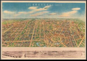
An authoritative score of road networks spans out in front of us; a pleasingly rectangular stamp on a colourful blue-sky background. This is Shinkyo. But if we adopt Michel de Certeau’s argument that a bird’s eye view of a city is inadequate and instead search for the spatial “acting out” of the city, does the “tour” of Shinkyo correspond with its “map”?[1]

In 1932, the Japanese developed a planning proposal which saw the Manchurian town of Changchun transformed into the visionary city of Shinkyo (also Xinjing) and represented the zenith of Japanese industrialisation and competition with the West. The city was developed closely in line with the ideals of the Japanese Guandong Army who had occupied Manchuria, and who prioritised state planning, economic domination, and a unified and obedient public.[2] The proposal included regular street layouts, European-style squares, parks, grand central buildings, and industrial domination. Notably, these developments occurred alongside the increasing importance of the South Manchurian Railway (SMR) which was imagined as the vehicle which would propel Shinkyo into a modernity beyond the access of the West.

The map (see below) was published in 1936 by the State Capital Construction Bureau of the State Council of Manchuria.[3] It is a bird’s eye view of Shinkyo, showing the construction plan with detail of individual streets, monumental centres, railway lines and shrine complexes. It is accompanied by a photographical print of the building progress on the city to that date. The publication of this map by the State Council is valuable in revealing the ideology of spatial reconstruction in Manchuria. The map is striking for its obvious grid pattern. Goto Shimpei, the SMR’s first president and contributor to the planning proposal for Shinkyo, was influenced by European city planning in Germany and subsequently introduced the idea of wide streets and zoned areas according to commercial, residential or commemorative function.[4] The map enhances the impression of this functional zoning by elevating the viewer so that the grid pattern is more pronounced and we adopt the view of the planner or architect who works on the landscape as if it is an operational subject. It implies that the planned vision of Shinkyo was developed independent of the realities of the Manchurian landscape or environment- the plan is flat, the planner has had no need for confrontation with mountains or freezing temperatures. Indeed, the grid pattern on the map fades off to the edges, where the landscape continues as a flat, blank canvas. Historians have categorised this as the utopian “blank page”, planning that only existed on paper.[5] It reveals the desire of Japanese authorities to spatially reconfigure a previously Chinese space into a new centre of Japanese modernity and industrialisation, without any cultural or social challenges. It suggests that city planning during the early 20th century adopted a unique “space-time conception”, where physical construction of roads, monuments and shrines could inaugurate a new era of progress that only Japan could access.[6]

This utopian vision of the future is seen in the detailed features of the map- uniform illustration of housing and additions of minute, unspecified people. This artistic representation disseminated as propaganda suggests that the planners had “free reign of creative vision” and did not include the reality of social structures within the lived city, a vision which filtered down into popular conception of Manchuria. It is true that the uniformity of their plan in some ways translated into reality. Shinkyo did become a hugely efficient commercial centre as the designation of certain spaces for economic and agricultural activity meant that the connective function of the SMR could be fully exploited, for example in the expansion of the soybean trade.[7] However, the static uniformity of the plan does not equate to the reality of 20th century Xinjiang. Even the photograph, evidenced alongside the drawing of the map as if to ratify the existence of the hexagonal dream, is taken before people are included into the equation of the city plan. The uniform housing excluded the presence of the Chinese, who were designated as the enemy, and consequently disrupted the utopia with the erection of immigrant houses on the outskirts of the city. This diverged from the Japanese-style housing and temples assigned on the map. Moreover, cottage industries (largely run by the Chinese) prospered, alongside the domination of the Chinese in banking and moneylending. A tarnish to the vision of a collective Japanese modernity. The map’s neglect of Chinese and Russian commercial districts is compounded by the tiny brushstroke figures we see pounding the streets. They are orderly and unidentified- they pose no social or nationalistic threat to the new Japanese modernity as they are all the same.

The lofty birds eye view of the map, whilst not representational of reality, is valuable in its suggestion of Japanese planning as a means to “scientifically manag[e] energy” in the newly acquired territory of Manchuria to create a distinctly Japanese space.[8] Whilst De Certeau rejected the engineered “concept city”, in the study of 20th century Japan, it becomes valuable for its insight into social and political aspirations.[9] City planning often involved the rejection of real forces of social and environmental change, but created an entirely new space in the administrative imagination- an uninhabited utopia where order and dominance could be asserted through spatial categorisation and management.


Bibliography

Primary Sources

Manshukoku Kokumuin Kokuto Kensetsukyoku, Kokuto Kensetsu Hansei Chikashi (Map of Shinkyo), (China 1936).

Secondary Sources

De Certeau, Michel, The Practice of Everyday Life, (California 1985).

Esherick, Joseph, “Railway City and National Capital: Two Faces of the Modern in Changchun”, in Joseph Esherick (ed.) Remaking the Chinese City: Modernity and National Identity, 1900-1950, (Hawaii 2000), pp.65-90.

Tucker, David, “City Planning Without Cities: Order and Chaos in Utopian Manchukuo”, in Mariko Asano Tamanoi (ed.), Crossed Histories: Manchuria in the Age of Empire, (Hawaii 2005), pp.53-82.

Young, Louise, Japan’s Total Empire: Manchuria and the Culture of Wartime Imperialism, (California 1988).


[1] Michel De Certeau, The Practice of Everyday Life, (California 1985), p.98, p.118.

[2] Joseph Esherick, “Railway City and National Capital: Two Faces of the Modern in Changchun”, in Joseph Esherick (ed.) Remaking the Chinese City: Modernity and National Identity, 1900-1950, (Hawaii 2000), p.65.

[3] Manshukoku Kokumuin Kokuto Kensetsukyoku, Kokuto Kensetsu Hansei Chikashi (Map of Shinkyo), (China 1936).

[4] Esherick, “Railway City”, p.74.

[5] David Tucker, “City Planning Without Cities: Order and Chaos in Utopian Manchukuo”, in Mariko Asano Tamanoi (ed.), Crossed Histories: Manchuria in the Age of Empire, (Hawaii 2005), p.60.

[6] Tucker, “City Planning Without Cities”, p.63.

[7] Ibid, p.70.

[8] Esherick, “Railway City”, p.81.

[9] De Certeau, The Practice of Everyday Life, pp.95-6.

Surgical Treatment of Organic Space: The Reconstruction of Seoul under Japanese Rule (1910-1945).

The Japanese Annexation of Korea in August 1910 prompted a rebuilding of Korean urban space under a Japanese state ideology. The Government-General worked to physically change the city of Keijo in particular, in order to mentally transform the identities of Korean colonial subjects in a project of assimilation. In his publication Assimilating Seoul: Japanese Rule and the Politics of Public Space in Colonial Korea, 1910-1945, Todd Henry describes the desacralisation of the Korean Royal House, state planning projects involving roads, harbours and street layout, government building construction and the alteration of sacred spaces.[1]  These were state-building colonial projects that sought to imbue Korea with a Japanese self-confidence in nationalism. The project of spatial reorganisation is recorded in Japanese government reports of the early 20th century which document the progress of urban construction in contrast with the “history” of Keijo and its inadequacies.[2] These reports are valuable in revealing the ideology behind spatial planning, but also in their more surprising corroboration with Henry’s argument that Japanese spatial organisation was not all subsuming.

The Annual Report on Reforms and Progress in Chosen, 1921-22, begins with a narrative on the history of civil engineering in Korea, bolstering the journal’s later claims of progress and innovation through a contrast with pre-colonial Korea. “Public properties were in a most neglected state and subject to abuse by the people”.[3] This implies that the state of Korean cities caused a disunity and lack of respect among their citizens, who are depicted as aggressive and barbaric. The attack on the physical stature of the city implies that the identity of Korea was being destroyed internally, consequently presenting the construction work of the Japanese as the rebuilding of national identity. This is ideology is evident in examples such as the Keijo City Planning Research Association which was established in 1921. The organisation placed emphasis on the scientific management of space to create an organic urban system which simultaneously overcame ethnic and class divisions.[4] This displays the ideological vision which is exposed in the Annual Report of 1921 that Korean society was a malleable entity which could become part of a larger Japanese nationality through their integration into the physical environment of the city. Consequently, the development targets for roadbuilding and harbours which the Annual Report mentions can be seen as part of a project to maintain an unbroken Japanese imperial line across borders. The historical report of conditions prior to colonial occupation describes roadbuilding as an “unknown science…preventing economic and cultural development”.[5] This further elevates the Japanese role as one of ‘saviour’ implying that they facilitated the emergence of Korea onto an international stage. This did occur as newly developed roads and other transportation networks facilitated lowered transport costs and the development of integrated market systems.[6] On the level of town planning, however, road development acted as a both a physical and metaphorical entity which cut through the ancient Korean past and reshaped the city as a focal point of modernity- “straightening, grading and widening” streets.[7]

However, in his publication, Henry suggests that the ideological development of Korean cities was not always successful, and that the Japanese ability to integrate Japanese and Korean citizens was “highly variable and partial”.[8] This was a result of the human ability to add additional layers of meaning to a space, which, observed through the analytical lens of Lefebvre, became a space of social struggle.[9] The Annual Report corroborates this, despite its celebratory tone. In road building “resort[ing] to the old custom [was] allowed only in the case of third-class roads, as these were closely connected with local interests”.[10] This implies that investment was concentrated at a central level, meaning that first and second-class roads which connected with the city centre and Japanese quarters were prioritised. It suggests that central planning was orientated toward the Japanese presence, resulting in uneven development and neglect of the smaller, local “capillary networks”.[11] Indeed, in the report, these local areas remain associated with an unsophisticated Korean past, implying that Japanese development projects were far from total or all-subsuming, supported by the statistic presented by Henry that 85.5% of Keijo retained its pre-colonial administrative boundaries.[12]

The Annual Report provided by the Japanese administration is valuable in revealing the ideology behind the physical transformation of Korean cities after its annexation. The 1921-22 report demonstrates the use of derogatory Japanese visions of old Korea in elevating their own colonial projects of improvement. Moreover, it demonstrates the use of town planning as both a physical and mental tool which was used to reshape and define Korea under Japanese terms of nationalism. This source is useful when examined alongside secondary literature such as Todd Henry’s Assimilating Seoul which assesses the limitations of Japanese town-planning as an ideological tool without practical implementation on all social levels.


Bibliography

Primary Source:

Government-General of Chosen, Annual Report on Reforms and Progress in Chosen (Korea), 1921-22, (Korea 1923), pp.159-167 <https://archive.org/details/annualreportonreformsandprogressinchosen korea192122/page/n203/mode/2up> [accessed 27th September 2021]

Secondary Sources:

Caprio, Mark, Japanese Assimilation Policies in Colonial Korea, 1910-1945, (Washington 2009).

Henry, Todd, Assimilating Seoul: Japanese Rule and the Politics of Public Space in Colonial Korea, 1910-1945, (California 2014).

Merrifield, Andy, Henri Lefebvre: A Critical Introduction, (2006).

Pao-San Ho, Samuel, ‘Colonialism and Development’ in Kenneth Pomeranz, Dennis O Flynn, Arturo Giraldez (eds), The Pacific in the Early Age of Industrialisation, (London 2009), pp.347-398.


[1] Todd Henry, Assimilating Seoul: Japanese Rule and the Politics of Public Space in Colonial Korea, 1910-1945, (California 2014), pp.28-32.

[2] Government-General of Chosen, Annual Report on Reforms and Progress in Chosen (Korea), 1921-22, (Korea 1923), pp.159-167.

[3] Annual Report on Reforms and Progress in Chosen (Korea), p.159.

[4] Todd, Assimilating Seoul, p.45.

[5] Annual Report on Reforms and Progress in Chosen (Korea), pp.159-160.

[6] Samuel Pao-San Ho, ‘Colonialism and Development’ in Kenneth Pomeranz, Dennis O Flynn, Arturo Giraldez (eds), The Pacific in the Early Age of Industrialisation, (London 2009), p.352.

[7] Annual Report on Reforms and Progress in Chosen (Korea), p.162.

[8] Todd, Assimilating Seoul, p.6.

[9] Andy Merrifield, Henri Lefebvre: A Critical Introduction, (2006), p.115.

[10] Annual Report on Reforms and Progress in Chosen (Korea), pp.159-160.

[11] Todd, Assimilating Seoul, p.37.

[12] Todd, Assimilating Seoul, p.37.

Defining National Identity and Claiming Modernity: The United States Consulate, Yokohama.

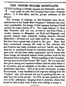
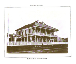
 The United States Consulate, Yokohama United States Consulate Text

The Ansei Treaties of 1858 ended Japan’s national exclusion through the development of treaty ports such as Yokohama, involving the country in an international trade network dependent on foreign accommodations and concessions. It has been suggested that the treaty ports became a “place of intersection for modern imperialism”. [1]  This is evidenced in The Far East publication’s article on the United States Consulate, which demonstrates a conflict between America’s cultural assumptions of its Japanese hosts and the necessity for a productive coexistence.[2]

The article places significance on the location and arrangement of the American Consulate buildings, implying that the physical landscape of the Treaty Ports acted as an authoritative stamp of foreign power, despite the lack of formal territorial possession. It states: “The building is directly opposite the Saibansho” and lists the varying functions of the Consulate itself. The spatial proximity of the buildings creates an impression of American dominance, where the Consulate acted as the capital of success. Indeed, the presence of the Consul’s private residence alongside national corporations, such as the US post office, implies that the infiltration of the US into Yokohama occurred on both a public and private level. Seemingly, traditional boundaries between administrative, commercial and domestic space were largely discarded in favour of the pervasion of a ‘total’ American identity. Social measures such as the importation of American food and the introduction of baseball were important accompaniments to this policy of cultural distinction from the Japanese.[3]

Despite this, the ensuing discussion of commerce in Yokohama presents a conflict between the retention of an American national identity and the necessity for interaction with Japanese industry. The writer’s commending tone toward American commercial success is heightened by the deliberate contrast with Japanese efforts of industrialisation. The writer suggests that the local community comprised of “loafers”, who were better off shipped across to America where they could experience the true meaning of modernity. This implies that American inhabitants of Yokohama subscribed to stereotypes that the Japanese were “essentially feeble” and that foreigners had a “moral imperative” to improve the situation of this isolated outpost.[4] Emphasis of “increased business” as a result of the Pacific Mail Company steamers suggests that the treaty port of Yokohama fostered solely American ambitions which dragged Japan into an international modernity, both physically and psychologically.

This description devalues The Far East’s article as a measured assessment of industrial development in the 19th century. Instead, it suggests that the concept of ‘modernity’ which was fostered during this time was a Western mediated phenomenon, rather than a progression which occurred on Japanese soil. It is true that Japan’s trade increased after foreign intervention- by the end of the twentieth century, Japan and China together supplied one third of the world’s silk.[5]  However, in contradiction, there was never one obsolete power in Yokohama. The intersection of West and East created a territorially ambiguous space where both powers met through commercial necessity. Cultural assumptions of Japanese inadequacy still prevailed but were reshaped and overridden by the necessity for interaction. Japan retained autonomy over the division of space in the port, where institutions were “lined up” and jockeying for valuable access to the water.[6] The derogatory description of the local community suggests that American survival depended on interactions with local Japanese as physical isolation was both impossible and detrimental. Imports from the West have been described as “the first step toward prosperity” for new Meiji Imperialism. The state propagated an image of aspirational Japan who acted as a facilitator of international trade, inserting themselves into the narrative of modernity which the Far East implies was exclusively ‘Western’.[7] Consequently, whilst the American presence was notable in Yokohama, it did not exist without interdependence on the locals, which stimulated a search for national identity on both parts. This made the treaty ports a unique setting, where national identities were forged and redefined in an environment of divergence.


Bibliography

Primary Source

Anglin, James, “The United States Consulate”, The Far East, Vol.1, No.18, (Yokohama February 1871), pp.5-6.

Secondary Sources

Ambaras, David, Japan’s Imperial Underworlds: Intimate Encounters at the Borders of Empire, (Cambridge 2018).

Bytheway, J, “The Arrival of the Modern West in Yokohama: Images of the Japanese Experience 1859-1899”, in Donna Brunero and Stephanie Villalta Puig, Life in Treaty Port China and Japan, (Singapore 2018), pp.246-267.

Hoare, James, The Japanese Treaty Ports 1868-1899: A Study of the Foreign Settlements, (London 1970).

Roden, Donald, “Baseball and the Quest for National Dignity in Meiji Japan.” The American Historical Review, vol. 85, no. 3, (Oxford 1980), pp. 511–534.

Taylor, Jeremy, “The Bund: Littoral Space of Empire in the Treaty Ports of East Asia”, Social History, Vol. 27, No.2, (2002), pp. 125-142.

Xu, Yingnan, “Industrialization and the Chinese Hand-Reeled Silk Industry (1880-1930)”, Penn History Review, Vol. 19, No.1, (Pennsylvania 2012), pp.27-46.


[1] David Ambaras, Japan’s Imperial Underworlds: Intimate Encounters at the Borders of Empire, (Cambridge 2018), p.71.

[2] James Anglin, “The United States Consulate”, The Far East, Vol.1, No.18, (Yokohama February 1871), pp.5-6.

[3] James Hoare, The Japanese Treaty Ports 1868-1899: A Study of the Foreign Settlements, (London 1970), p.111. Donald Roden, “Baseball and the Quest for National Dignity in Meiji Japan”, The American Historical Review, vol. 85, no. 3, (Oxford 1980), p.512.

[4] Roden, “Baseball and the Quest for National Dignity”, p.152.

[5] Yingnan Xu, “Industrialization and the Chinese Hand-Reeled Silk Industry (1880-1930)”, Penn History Review, Vol. 19, No.1, (Pennsylvania 2012), p.31.

[6] Jeremy Taylor, “The Bund: Littoral Space of Empire in the Treaty Ports of East Asia”, Social History, Vol. 27, No.2, (2002), p.134.

[7] J. Bytheway, “The Arrival of the Modern West in Yokohama: Images of the Japanese Experience 1859-1899”, in Donna Brunero and Stephanie Villalta Puig, Life in Treaty Port China and Japan, (Singapore 2018), p.256.