Tea WG and Imperial Nostalgia in Hong Kong

Hong Kong was one of the last British colonial holdings to be decolonized – with the handover of the territory to Chinese authorities taking place in 1997. With only around two and a half decades having passed since then, the legacies and memory of Hong Kong as a part of the British Empire still hold significant influence within the territory. One of the most dramatic displays of this influence could be seen in the 2019-2020 protests, where protesters could be seen waving British flags, and the flag of colonial Hong Kong.[1] Outside of these political displays however, cultural legacies of Hong Kong’s past can be viewed in other places – including commercial settings.


The Tea WG company was founded in 2008 in Singapore, and has quickly established itself as a prominent multinational business within its area of tea, basing its brand identity around luxury.[2] Within the 2010s, the business has expanded operations within Hong Kong, opening new stores and restaurants – of which the latter are especially interesting to examine from a spatial standpoint.[3]


The stores themselves create a ‘colonial’ atmosphere through their aesthetics. They are bright and colorful stores, with large open windows and a golden-yellow tinted color palette. Rows and rows of tea caddy tins line the interior of these stores, some given evocative colors and names such as ‘Jade Dragon’ and ‘French Earl Grey’.[4], [5] All of these elements serve to create an image of a kind of cosmopolitan, colonial and perhaps Victorian establishment, where one can experience the opulence associated with this romanticized picture. There are other elements that also contribute to the creation of this experience – for example, the staff of TWG outlets dress in formal, somewhat old styled attire that evoke Victorian images of butlers and maids.[6] One of the key attractions of the outlet in the form of its afternoon tea also furthers this experience with its use of classic European-esque dishes and food.[7]


One potential explanation about the unique set of arrangements that TWG restaurants utilize is that the atmosphere is appealing to the significant expatriate community of Hong Kong and the considerable number of non-Chinese tourists the city attracts. But other examples of similarly styled businesses – such as the Cova chain of coffee shops – the relative level of success and proliferation of the TWG business, and the previously mentioned cases of British flags being woven in political protests all suggest something more than simple appeals to tourism and expatriates. Rather, what this all suggests is that there is a sentiment amongst at least a significant portion of the Hong Kong populace that has a degree of nostalgia for the colonial period, a nostalgia that some businesses have attempted to take advantage of by theming themselves in an appropriate manner.

[1] Sum Lok-kei. ‘Why Hong Kong Protesters Wave US and British Flags’. South China Morning Post, 22 August 2019.

[2] La rédaction. ‘TWG Tea, the Best of Tea since 2008’. Luxe Magazine, 2017.

[3] Castagnone, Mia. ‘Singaporean Luxury Tea House Aims to Win over Chinese Consumers’. South China Morning Post, 3 October 2021.

[4] ‘Tea WG Boutique at Hong Kong International Airport (香港國際機場精品店)’, 2022. https://teawg.com/international-airport.html.

[5] Yu, Helen. ‘Tea Time: 8 New Afternoon Tea Sets To Try In Hong Kong This Season’. Tatler Asia, 4 October 2019.

[6] Tripadvisor. ‘TEA WG AT IFC MALL, Hong Kong – Central’, n.d. http://www.tripadvisor.com/Restaurant_Review-g294217-d3237777-Reviews-Tea_WG_at_IFC_Mall-Hong_Kong.html.

[7] Yu, Helen. ‘Tea Time: 8 New Afternoon Tea Sets To Try In Hong Kong This Season’.

The Buddhism Centered Chinese Exhibit at the British Museum, London

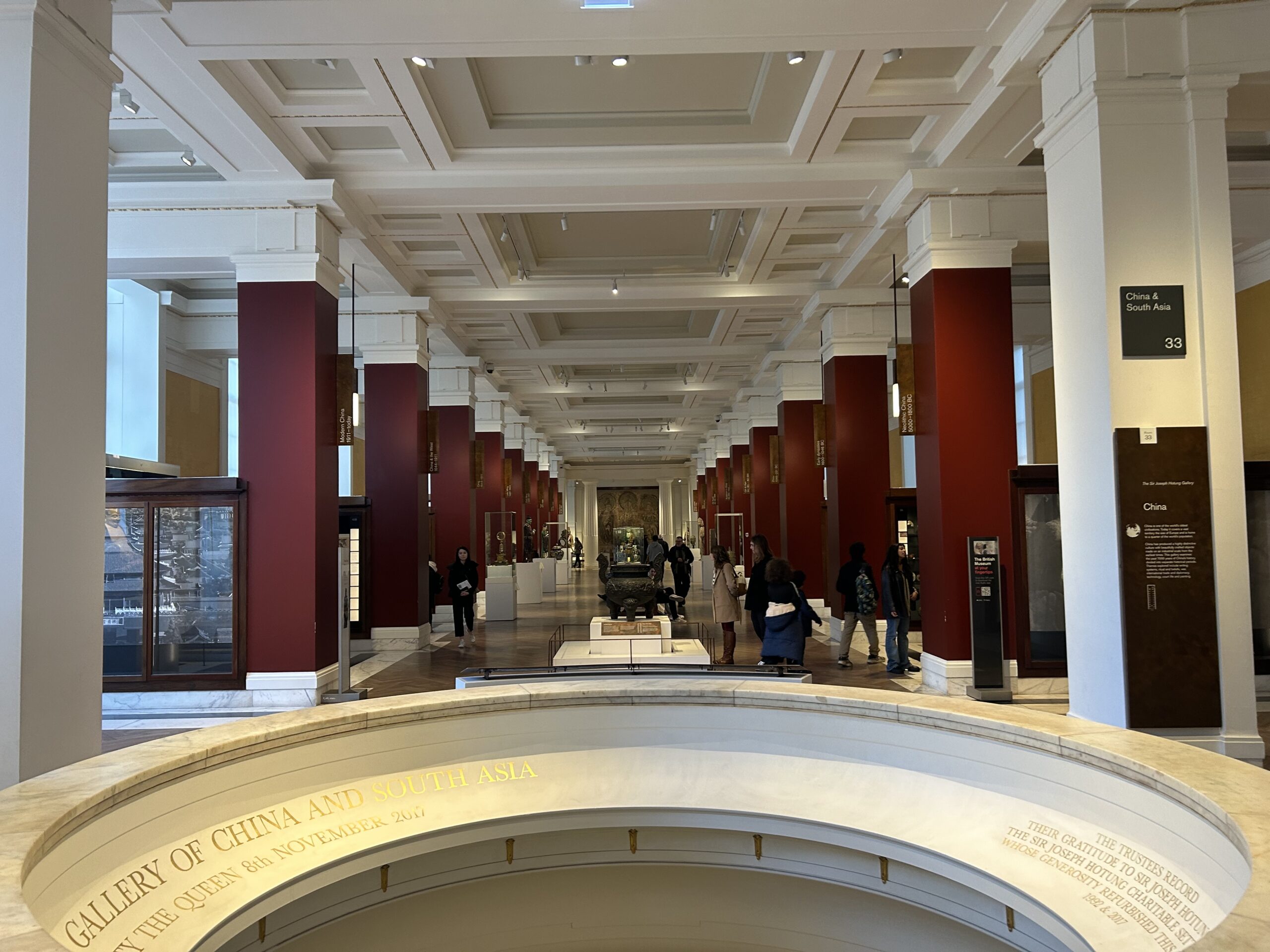
The British Museum has a surprising amount of space dedicated to Asia, and specifically China – aside from sections devoted to Chinese jade and its products, and a rather extensive and well cataloged section devoted to Chinese porcelain, there is a section devoted to the region itself. While the fact that entire sections are dedicated to Chinese jade and porcelain is in itself worth examining from a spatial standpoint – ascribing a large degree of focus on the categorization of these singular types of items – what is especially interesting is the framing of the Chinese history section around Buddhism.

Green, Brendan. Overview of the Gallery of China. September 2, 2023. Photograph, 4032×3024 pixels.

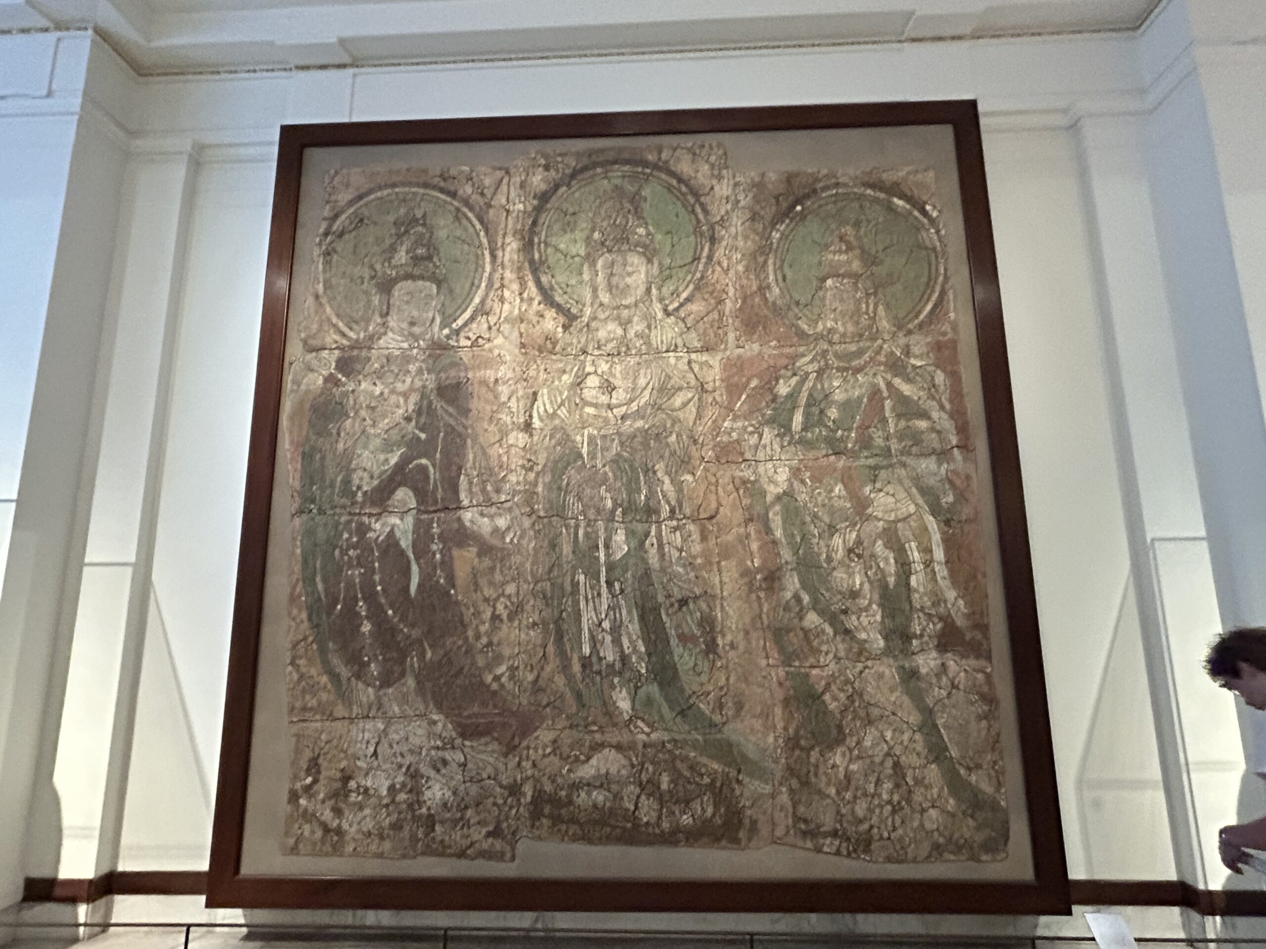
The initial view of the section as one enters it is striking – red pillars flow from the front to the back of the area, separating the different subsections. The impression is almost like that of a temple – something that is strengthened by the display in the far back and center of the section. The display is that of three Bodhisattvas overlooking the entire area, dwarfing most of the exhibit physically. If there is a visual narrative created by the spatial layout of the section, it is one that places Buddhism at the center of Chinese history.

Green, Brendan. Three Bodhisattvas Overlooking the Gallery. September 2, 2023. Photograph, 4032×3024 pixels.

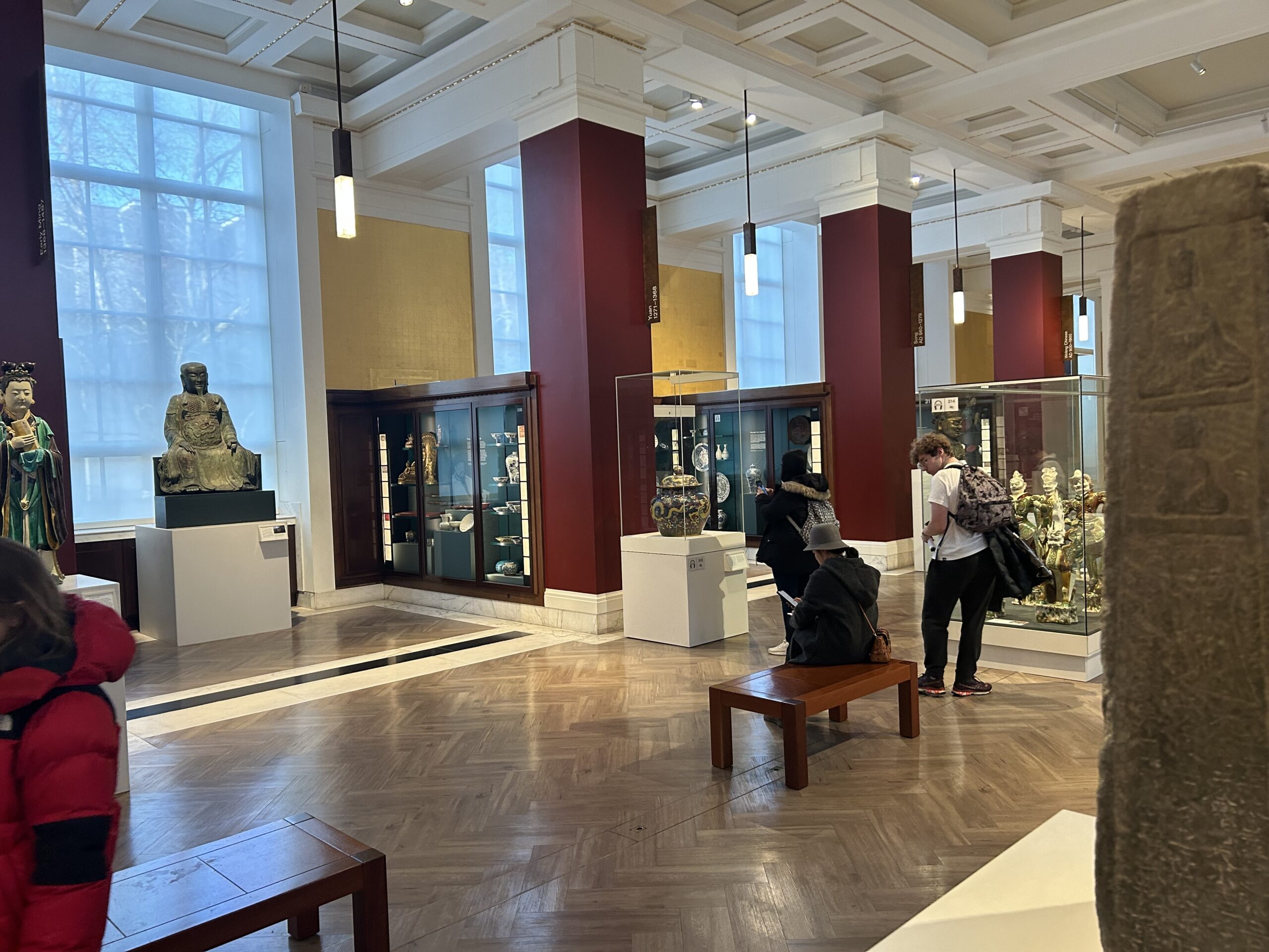
The subsections of the area also place an emphasis on Buddhism – for the most part, these sections divide China along temporal lines, by constructions such as ‘early’ and ‘modern’ China, and along dynastic lines. One of the few exceptions to this is the subsection completely devoted to Buddhism in China.

Green, Brendan. Structure of the Gallery of China. September 2, 2023. Photograph, 4032×3024 pixels.

The focus that the section places on Buddhism is noteworthy because while Buddhism is important in Chinese history, it is far from the most important or only element in the history of Chinese religion, culture and spiritualism. Taoism and Confucianism go nearly unmentioned throughout the entire section, while displays that contain artifacts relevant to non-Buddhist religious and spiritual practices are discussed outside their respective contexts.

It is difficult to ascertain exactly why the British Museum decided to frame its China exhibit around Buddhism. One possible reason is due to material limitations – perhaps the Museum simply did not have access to as many artifacts related to Taoism and Confucianism as they did Buddhism. Perhaps the Museum decided that centering the section around the display of the three Bodhisattvas would make for a striking and dramatic image, and themed the section to match. Regardless, it is an interesting example of how a museum can construct narrative through spatial arrangement.  

Asian Virtual Spaces – An Understudied Area?

It is a common sentiment that the internet age has brought on rapid and radical changes to the world in almost every aspect – creating new and commonly used methods of communication, information exchange, industry, and so on. Despite all of this, the spatial dynamics and history of the internet age remains woefully understudied in an academic context. In this short blog post, I wish to make the case for ‘virtual spaces’, or perhaps more accurately, spaces adjacent to the virtual as being worthy of dedicated study, and as being important in modern cultural history. In my opinion, South Korea offers some particularly rich examples that are worthy of academic attention.


While the PC Cafe exists as a concept and space in western culture, it is often associated with negative images. The PC Cafe is often conceived as being grimy, worn down, outdated and in general far from an appealing space – something that stands in stark contrast to the South Korean ‘PC방’ or ‘PC Bang’. The PC Bang is defined as a space that is appealing and unique from a PC Cafe, despite the fact that at the most basic level, both spaces offer similar services.[1] This is a space that is obviously and unambiguously associated with the virtual – PC Bangs seen primarily as a place where people can play specifically online competitive video games, many of which involve teamwork and communication – an example being the ever popular League of Legends. While it would be a mistake to overemphasize the importance of these spaces in South Korean culture, their rise to prominence in the late 1990s and 2000s – long before video games, especially in a competitive context, would enter the ‘mainstream’ – and their alleged prominence amongst the younger generations in South Korea suggests that there is potentially unique spatial dynamics at play.[2]


The PC Bang is also closely associated with another spatial construction relatively unique to South Korea – that of the esports ‘event’ – a broad analogue to a sports event, where organized leagues test the skills and abilities of the best players of a specific video game. The two key factors that in my opinion make these events worth analyzing from a spatial construction is their notable level of popularity and complexity. In the case of the latter, esports events and leagues in South Korea have been historically able to construct elaborate studios and stages to facilitate themselves. An example can be found in that of the permanent studio utilized by the Global Starcraft II League, or GSL – which is covered in lights and displays, seating for spectators, live commentators in both English and Korean, and an atmosphere that is analogous to that of a baseball stadium, but still unique.[3] Regarding the point of popularity, esports events in South Korea have demonstrated the ability to draw in significant live crowds – one example can be found in the 2005 ProLeague finals, which saw over 100,000 people arriving live to watch two teams compete in Starcraft: Brood War.[4] While esports events in the 2000s in the west mostly consisted of grass roots, community driven events, esports events in South Korea were considered popular enough to warrant the investment of large businesses such as SK Telecom and the KT Corporation, respectively responsible the successful and roughly two decades old esports teams known as T1 and KT Rolster.


While the examples discussed in this short post are based in South Korea, there are similar cases of unique and influential virtual spaces across East Asia as a whole, which only further emphasizes the unmined potential in this area of research. Virtual spaces are also interesting in my opinion due to their very modern origins and fast rate of development. While this does pose challenges in terms of research, with an overload of available information making separating the useful information from noise difficult, the entrenchment of the internet in modern life means that is almost certainly going to be a problem that historians will have to deal with at some point.

[1] Tae-gyu, Kim. ‘`PC Bang’ Emerges as New Way of Promotion’. The Korea Times, 23 July 2007.

[2] Tae-gyu, Kim. ‘`PC Bang’ Emerges as New Way of Promotion’.

[3] Olsen, Creighton. ‘GSL Studio: The Heart And Seoul Of Starcraft’, 13 January 2020.

[4] Erzberger, Tyler. ‘Beaches of Busan Awash in Esports History’. ESPN.Com, 28 July 2017.

The Presented Spatial Dynamics of Chinese Communes During the Cultural Revolution

‘People’s Communes’, or ‘人民公社’ were one of the key elements of the ill-fated Chinese Great Leap Forward of the late 1950s and early 1960s. Alongside the ‘Four Pests Campaign’  (除四害) and the ‘Backyard Furnaces’ (土法炼钢), the People’s Communes are one of the most well known aspects of the Great Leap Forward. An ambitious project of collectivization, it consisted of combining small agricultural communities into communes, eradicating private ownership and basing life around communal facilities and work. While the economic failings of the People Communes – both in their theory and practice – are well understood, one the most interesting, yet understudied elements of these Communes are their spatial dynamics.

Using a small sample of contemporary posters based around the subject, I want to explore two key themes that seem to be common in the presented spatial dynamics of the People’s Communes.

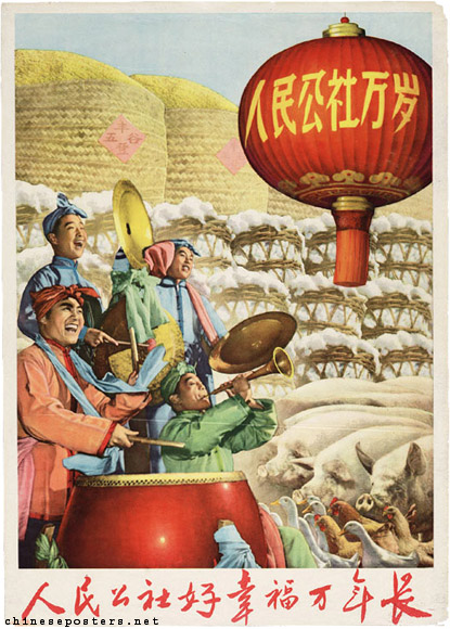
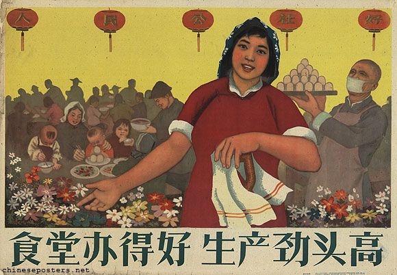
The first theme – one that is overwhelmingly present in nearly every propaganda poster relevant to the People’s Communes – is that of material plenty, of bountiful harvests and overflowing stores of foodstuffs. This theme is evident even in posters that are disconnected from agricultural topics. For example, the poster ‘When the dining hall is well-run, the production spirit will increase’ designed by Hu Yuelong, which focuses on the communal dining halls of the People’s Communes, features a large platter of food being brought to the already eating denizens of the hall.[1] However the poster which emphasizes this aspect of the People’s Communes the most is ‘The people’s commune is good, happiness will last for ten thousand years’, created by an unknown designer.[2] While the band of people takes prominence in the foreground of the image, they are physically dwarfed by agricultural produce, which dominates the background of the poster.[3] Huge, overflowing baskets of wheat and wool tower towards the sky, while the ground itself is obscured by a swarm of pigs and chickens.[4] The image’s sense of perspective also gives the sensation of the barrels continuing beyond the confines of the poster – creating an overall impression of boundless plenty, of an environment that can provide the many with even more.[5]

‘The people’s commune is good, happiness will last for ten thousand years’ 

‘When the dining hall is well-run, the production spirit will increase’


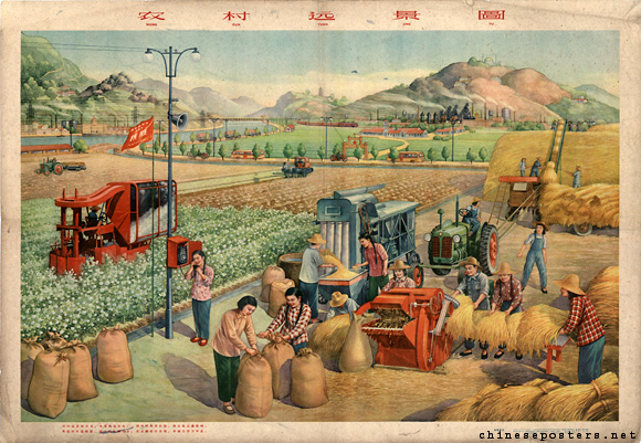
The second theme is that of generational harmony and cooperation – of the old and the young living and working together in harmony. This is a slightly more subtle theme, rarely if ever the primary point of the singular poster, but is near ever present, a consistent element throughout many of the posters. Hu Yuelong’s ‘When the dining hall is well-run, the production spirit will increase’ once again provides an example – with young children in the background, an older man in the middle ground, and a young adult woman in the foreground of the image.[6] Of particular note is the older man and the young adult woman, who appear to be both workers in the dining hall, with the older man carrying food, and the young adult woman carrying a tea cloth – creating an impression of the generations working, eating and living together.[7] The poster ‘The future of the rural village’ created by Zhang Yuqing provides another example of this theme, showcasing a future where farmers work in tandem with mechanized equipment in a rural setting.[8] The image creates an impression of old and new working together in multiple ways – the first being the rural, almost traditional setting of the image, with rolling hills under blue skies – being populated by artifacts of modernity – an electrical pole, a telephone, and mechanized farming equipment.[9] Another way in which the image furthers this theme is in the clothing of the people depicted in the image. Their clothing is for the most part modern – with jeans, overalls, and patterned shirts being prominent – but stands in contrast with their hats, which appear to be more traditionally styled, resembling ‘dǒulì’ or ‘斗笠’ style hats.[10] Theme of harmony between generations is more esoteric in its presentation in ‘The future of the rural village’, but is still present, speaking more to concepts of older traditions and new innovations working harmony, while ‘When the dining hall is well-run, the production spirit will increase’ is more concerned with harmony across human generations.


‘The future of the rural village’


Obviously, it would be foolish to take the presented themes discussed here at face value – not only because it is just a small slice of the larger concept of the People’s Communes, but because the lived experience of these Communes differed tremendously from the ideas that drove them. Still, there is use in examining the presented spatial dynamics of them as it allows us to assemble a more complete image of the planning and mindset that informed the Great Leap Forward as a whole – something, that in my opinion, requires further investigation.

[1] Hu Yuelong. When the Dining Hall Is Well-Run, the Production Spirit Will Increase. December 1958. Print, 53×77 cm.

[2] Unknown. The People’s Commune Is Good, Happiness Will Last for Ten Thousand Years. 1960. Print, 75×54 cm.

[3] Unknown. The People’s Commune Is Good, Happiness Will Last for Ten Thousand Years.

[4] Unknown. The People’s Commune Is Good, Happiness Will Last for Ten Thousand Years.

[5] Ibid.

[6] Hu Yuelong. When the Dining Hall Is Well-Run, the Production Spirit Will Increase.

[7] Hu Yuelong. When the Dining Hall Is Well-Run, the Production Spirit Will Increase.

[8] Zhang Yuqing. The Future of the Rural Village. April 1959. Print, 53.5×76.5 cm.

[9] Zhang Yuqing. The Future of the Rural Village.

[10] Ibid.

Coffee Evenings in the Hong Kong MTR

The Hong Kong Mass Transit Railway, or MTR, seems to have been rapidly integrated into the day-to-day life of the city since the opening of the Modified Initial System route in 1979. The MTR Corporation’s Annual Report from 1979 is proof enough of this, giving the impression in no uncertain terms that the Corporation was pleased with how the system had been received by the general public.[1] Since then, the system has continued to expand both in size and popularity, with the Modified Initial System being expanded into the Tsuen Wan and Island lines over the course of the 1980s, and the Tseung Kwan O and Airport Express lines over the course of the 1990s, and so on going into the 21st century. One curious, and underreported element of the MTR’s expansion during this period is their method of gathering customer feedback. Instead of the more conventional approaches to gathering feedback, the MTR made use of so-called ‘Coffee Evenings’ hosted at MTR stations, starting in 1991.[2] These took the format of sit down events, taking part in the early evenings, where members of the public would be able to offer their opinions on the MTR to management staff.[3] The issues described as being commonly raised are not especially surprising or of particular interest – being matters such as air conditioning, cleanliness, and service announcements.[4]

What is of particular interest to me is how these events were specifically conducted – what atmosphere they carried, and how the management of the MTR corporation attempted to present themselves with. Unfortunately, the available information on these events is sparse at best – the only information on them that I could find online is documentation from the MTR Corporation itself, in the form of press releases transcribing announcements relating to the events, and the ‘Staying On Track With Your Views’ series, which are annual reports where the MTR responds to the feedback they have received. The limitations of these sources in finding out what these events looked and felt like are obvious – including especially negative or dramatic experiences would not be in the interest of the MTR Corporation, and positive feedback is likely to be focused on disproportionally. Still, these booklets are still useful in presenting the idealized image of the MTR’s Coffee Evenings.

An example of this image can be found in the 1993 edition of Staying On Track With Your Views, which uses a photo of a Coffee Evening as its front page.[5] The atmosphere presented in the photo is friendly, calm, and approachable – with what appears to be relaxed conversations taking place[6]. Plants are scattered around the area, and people of all ages – from children to businessmen – are present, creating an environment not unlike that of a coffee shop.[7] This relaxed and approachable tone is also conveyed in the letter included in the booklet – it ‘cordially invite(s)’ the public to provide feedback, and even includes a phone number that can be used to this end.[8]

As previously mentioned, any further analysis of the MTR’s Coffee Evenings is unfortunately hampered by the lack of available material, especially with regards to material that provides alternative viewpoints – to put it in short, only half of the story has been told. Further investigation is absolutely warranted – given how quickly the MTR seems to have embedded itself into Hong Kong, a more thorough examination of these feedback sessions would perhaps shine a light on the dynamics and lived experience of the MTR in this period, and how the corporation and the public engaged with each other.

[1] Mass Transit Railway Corporation. Annual Report of the Mass Transit Railway Corporation, 1979. 6.

[2] Mass Transit Railway Corporation. Press Release, 1995. 5.

[3] Press Release, 1995. 2.

[4] Ibid. 6.

[5] Mass Transit Railway Corporation. Staying On Track With Your Views, 1993. 1.

[6] Staying On Track With Your Views, 1993. 1.

[7] Ibid. 1.

[8] Ibid. 22.

Long Essay Prospectus – The Hong Kong MTR as a Contested Space

The Hong Kong Mass Transit Railway, often abbreviated as the MTR, is one of the key focal points of the city, for better or for worse. It is often the subject of artistic endeavors that seek to capture the ‘essence’ of Hong Kong[1], used as synecdoche for the lived experience of the city[2] and used as a vehicle to define the city in a global context.[3] It is also a deeply political space – a space that has been at the centerpiece of much of Hong Kong’s political disputes in recent years. Most famously, the MTR has been sight of protests[4] during the city’s recent bouts of political unrest but has also been put at the center of less dramatic political issues – an example closely related to the 2019-2020 Hong Kong protests is that of the question of mainland jurisdiction over the Express Rail Link.[5]

Given the importance of the MTR, an examination of it as a contested space utilizing related spatial theory seems warranted and does not seem to have been performed yet in an academic context. Other, more well studied examples of contested spaces in South East Asia, such as Brenda Yeoh’s Contesting Space in Colonial Singapore could be used in order to provide points of reference and comparison.[6] The MTR itself is rife with room for spatial analysis, even outside of the context of investigating it as a contested space. For example, the MTR has a dedicated, long running project of integrating art into its stations, using the space as a place for exhibition.[7] Theories of messy urbanism[8] can also be applied to the Hong Kong MTR as a contested space, with incidents such as the aforementioned protests and a 2018 case of graffiti on the MTR representing some of the innate tensions of a messy urban environment.[9]

To sum up, I believe there is a strong case for a thorough investigation of the Hong Kong MTR as a contested space. There is a wealth of primary sources available – outside of the images of and reporting on the 2019, 2014 and 2003 Hong Kong protests, smaller scale incidents such as a dispute over musical instruments being carried in the MTR are also useful for this investigation.[10] Government and corporate statements on varying issues relating to the disruption of the MTR may also prove useful. As previously mentioned, there is a lack of existing academic work on the MTR as a contested space, but studies of other East Asian contested spaces may provide insight into the Hong Kong case. Finally, spatial theories, such as that of messy urbanism have obvious ways in which they can be applied to the Hong Kong MTR.

[1] HKFP Lens. ‘HKFP Lens: Helen Gray Sets out to Capture the Spirit of Hong Kong’s MTR… from Exit A1’. Hong Kong Free Press HKFP, 3 February 2019.

[2] Chung, Jack. ‘Officials Should Take the MTR Regularly to Understand Public Unhappiness’. South China Morning Post, 21 December 2021.

[3] Chan, Bernard. ‘In Praise of Hong Kong’s MTR – Still One of the Best in the World’. South China Morning Post, 17 December 2021.

[4] Leung, Hillary. ‘The Crisis Facing Hong Kong’s Subway System’. Time, 25 October 2019.

[5] Cheng, Kris. ‘Pro-Democracy Lawmakers Boycott Visit to Express Rail Link Terminus until Legal Questions Are Answered’. Hong Kong Free Press HKFP, 2 August 2017.

[6] Yeoh, Brenda S. A. Contesting Space in Colonial Singapore: Power Relations and the Urban Built Environment. NUS Press, 2003.

[7] MTR. ‘Art in MTR’. Accessed 8 October 2022. http://www.artinmtr.com.hk/.

[8] Chalana, Manish, ed. Messy Urbanism: Understanding the ‘Other’ Cities of Asia. Hong Kong University Press, 2016.

[9] Lai, Catherine. ‘MTR Train Covered in Graffiti Appears on East Rail Line during Peak Hours’. Hong Kong Free Press HKFP, 13 March 2018.

[10] Cheng, Kris. ‘Veritable Orchestra of Instruments Promised in Protest against MTR’s “selective” Enforcement of Bylaws’. Hong Kong Free Press HKFP, 25 September 2015.

Manchukuo as an Imagined Space

The Japanese colonial project in Manchuria stands as being unique amongst the pantheon of colonial projects in China. Where the treaty ports were Chinese cities with portions carved out by western concessions, and fully foreign controlled regions like Hong Kong were limited in geographical scale, the Japanese puppet state of Manchukuo was expansive in scope and scale – more comparable to the settler colonization projects of Africa or Australia. Manchuria was subject to grand, utopian Japanese visions and designs – something that David Tucker explores in his essay City Planning without Cities, Order and Chaos in Utopian Manchukuo.[1] One particularly striking element discussed by Tucker is how Japanese urban planners conceptualized Manchuria. Tucker describes how Japanese urban planners explicitly saw Manchuria as a ‘blank slate’ – an empty, flat, virgin canvas on which they could paint their utopia.[2] This conception of Manchuria colors every part of the resulting plans – most strikingly in the wider geographical layout of the planned communities which take strict geometric shapes, with no consideration for natural features, already existing communities, and economic viability.[3] This plan of standardized hamlets has a number of fatal flaws seemingly total and disconnected – but the concept of imagined space can help piece them together.

The thinking behind the hamlet plan represents a very explicit example of Henri Lefebvre’s concept of imagined or mental space in action.[4] As discussed by Lefebvre, mental space is conceptual in nature – it may be based on some set of guiding principles, perhaps even a conception of reality, but it is by its standard nature an unconstrained, uncontested space.[5] Lefebvre uses this concept to critique the assumptions and ideas of other academics, framing mental space as an unconscious prior.[6] This divide described by Lefebvre between the physical and mental space is extremely applicable to the manner with which Japanese urban planners approached Manchuria.[7] Tucker discusses how the urban planners did study the lifestyle of Japanese farmers and applied those lessons into their designs, but did so in a way that simplified and removed nuance from the lives of farmers.[8] This flawed conception of the lived experience of farmers was the basis for the geometric layout of proposed hamlets[9], something which fed into many of the other numerous flaws with the hamlet proposal, notably including its security flaws, economic flaws and logistical flaws.[10]

Where Lefebvre uses the concept of imagined space to expose the flaws and failings of academic ideas and theories – concepts that are difficult to ‘defeat’ with finality – imagined space is useful in revealing the links between the common elements between the varying flaws of the hamlet proposal. This is a textbook example of how spatial theory can be used to analyze colonial projects and urban planning – an while the implications of spatial theory may be somewhat obvious in this case, similar examples of flawed conceptions of imagined space can be found in other colonial projects of all shapes and sizes – from French Indochina to the British Raj to the wider Japanese Empire.

[1] Tamanoi, Mariko. “City Planning without Cities, Order and Chaos in Utopian Manchukuo.” In Crossed Histories: Manchuria in the Age of Empire, 53–81. [Ann Arbor], Honolulu: Association for Asian Studies ; University of Hawai’i Press, 2005.

[2] Tamanoi, Mariko. “City Planning without Cities, Order and Chaos in Utopian Manchukuo.” 55.

[3] Ibid. 58-62.

[4] Lefebvre, Henri. “Plan of the Present Work.” In The Production of Space, 1–67. Oxford, OX, UK ; Cambridge, Mass., USA: Blackwell, 1991.

[5] Lefebvre, Henri. “Plan of the Present Work.” 3-4.

[6] Ibid. 4-6.

[7] Ibid. 6.

[8] Tamanoi, Mariko. “City Planning without Cities, Order and Chaos in Utopian Manchukuo.” 62-63.

[9] Ibid. 66.

[10] Ibid. 66-71.

Hong Kong and the Grand Model

Hong Kong stands alongside Singapore, Bombay and New Delhi as being one of the most well known and defining spaces of the British colonial enterprise in Asia. But unlike the aforementioned cities, Hong Kong is unique in its relatively late date of colonization, being ceded to the British in 1841. This places the city in a rather unique period in terms of British colonial urban planning – the ‘Grand Model’ that had dominated the approach to colonial urban planning was reaching the end of its over two centuries long tenure.[1] Towards the end of the 1840s, arguments that favored a hands off laissez faire approach to urban planning would prevail, and remain dominant going into the tumultuous 20th century.[2] In short, Hong Kong represents a unique opportunity to evaluate the principles and practice of the ‘Grand Modell’ at its most developed point – and while the Australian city of Adelaide can provide a similar example,[3] the character of the British colonial project in Australia is sufficiently different to warrant another example. Where in the British colonial projects in places like India and China had relatively powerful and well organized local communities and governments that they were forced to engage with in some way, the Indigenous communities of Australia were systematically excluded and in many cases destroyed.

To aid this analysis, a map of Hong Kong from 1958 produced for the American Mobilgas company[4] will be used. The reasoning for the use of this particular map is twofold. Firstly, being produced in the late 1950s, the urban environment of Hong Kong has had time to develop, but the pressures of the World Wars and Great Depression would have made the prospect of any new urban designs at best difficult to implement. Secondly, the map being of an American origin lends it an advantage – while it is obviously far from an extremely accurate, unbiased presentation of Hong Kong, it is disconnected from the immediate context of the British and the systems of British colonial administration. It also clearly has a utilitarian purpose, most likely being used by tourists – meaning it is less likely to be a rendition of how Hong Kong ‘should be’ – at least from an urban planning perspective. One important limiting factor that should be mentioned is that the map only covers a small space of Hong Kong – mostly the areas enclosing Hong Kong bay, while the New Territories, Sai Kung, a significant portion of Hong Kong Island and Kowloon have been excluded from the map. The map is also not suitable for discussing the third and fourth principles of the Grand Model that Robert Home describes – we cannot use a map intended for consumption by tourists to give us an insight into whether or not Hong Kong was laid out in advance, nor can we use it to determine the exact size of the many main roads marked on the map[5].
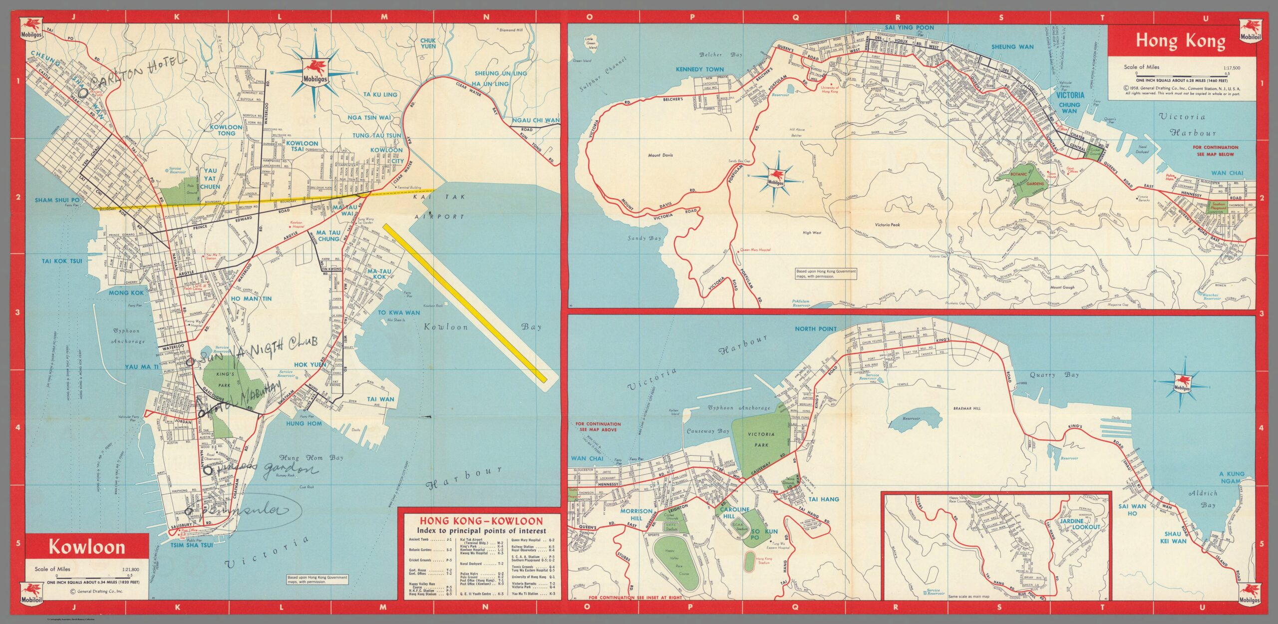
https://www.davidrumsey.com/luna/servlet/detail/RUMSEY~8~1~299701~90070709:Kowloon–Hong-Kong-

The first principle of the Grand Model as defined by Robert Home is ‘deliberate’ urbanization – in short, strong central authorities prominent throughout or dominating the urban landscape.[6] This principle is displayed in the Mobilgas map of Hong Kong, especially on Hong Kong Island itself – the organs of the colonial administration (government offices, post office, police headquarters, barracks) are clustered around two major roads, Queen’s Road East and Queen’s Road Central, while roughly lying in the center of the urban build up on Hong Kong Island.[7] They also sit in close proximity to the ferry piers that are essential for travel between Hong Kong Island and Kowloon.[8] It should be mentioned however that this principle does not appear to be as strongly applied to Kowloon – while there is a post office and railway station sitting at the south end of the central Nathan Road, there is little else in the way of administrative organs or buildings symbolic of the British colonial administration on the mainland – something that seems strange at face value given the seemingly larger scale of the urban environment in Kowloon.[9] In short, the principle of deliberate urbanization in Hong Kong has been partially followed.

The second principle defined by Robert Home is that of land rights allocated in clearly differentiated regions of town, suburban, and country lots, something that Home describes as being definitively tied into the program of deliberate urbanization.[10] Where the previous principle is displayed in the 1958 urban landscape of Hong Kong, this principle is completely absent. Hong Kong, as displayed in this map, is a nearly totally urban environment, with the few suburban locations having no distinct boundary between themselves and the urban, and the country being not present at all.[11] The majority of the northern Hong Kong Island displayed on this map is an almost uninterrupted urban sprawl following tightly along the coast line, running from Kennedy Town to North Point, only interrupted by Victoria Barracks and the naval dockyard.[12] The inset displaying Jardine Lookout has an identifiable suburban structure with small winding avenues and roads, but is directly connected to the bustling urban environment north of it by the Happy Valley Race Course and Stubbs Road[13]. The layout of Hong Kong Island appears to have more in common with the concept of a treaty port and opposed to a colonial township. Meanwhile, the section of Kowloon displayed on this map is a wall of urban space that seemingly sheers off straight into nothing north of Clear Water Bay Road, Tai Po Road, Kowloon Tong and Kowloon Tsai.[14] It is worth mentioning that the limitations of the Mobilgas map as a source are apparent in this discussion – as mentioned before, it only covers a small region of Hong Kong, leaving out for example, the fishing villages of Sai Kung, and the expanse of the New Territories. Its purpose as a guide for American tourists may also be a limiting factor – with most of the interest of the map on the urban spaces of Hong Kong, the mapmakers may have simply not bothered to describe in detail the non-urban spaces of Hong Kong. However, even with those caveats in mind, it is reasonable to conclude that there is at the very least a lack of a consideration for the principle of differentiated regions of urban, suburban and country displayed in Hong Kong. This discussion also ties into the eight principles discussed by Robert Home, being that of a clear green space separating the town and the country – for the reasons already discussed above, it is fair to conclude that this principle was also at the very least disregarded.[15]

The fifth, sixth, and seventh principles laid out my Robert Home – respectively, that of a rectangular, grid based plot layout, the presence of public squares, and the reservation of plots for public purposes[16] can also be discussed in sum, as they are intertwined with each other due to the condensed nature of Hong Kong’s urban environment. To start, Hong Kong does display a rectangular grid layout, but not a standardized one.[17] While Hong Kong’s plots are nearly rectangular across the board, all flowing from a main road, they are not standardized, with many subsections of the urban space having different orientations and sizes for their plots – compare, for example, the rectangular layouts flowing out from the nearly parallel Nathan Road and Ma Tau Wei Road in Kowloon[18]. These layouts are also interrupted at several points by public places – typically gardens, that seem to be centrally located ala a public square[19]. For example, Southorn Playground in Wan Chai lies at the center of the urban space surrounding Hennessy Road, but in doing so interrupts the standardized grid plots surrounding Hennessy Road and Queen’s Road East.[20] A more prominent example is that of King’s Park, lying at the center of Kowloon – King’s Park does not conform to any kind of grid layout, and indeed represents a significant break from the sprawling grid layout to its east, west and south.[21] Taken in sum, I argue this represents an adherence to the spirit of the relevant principles, but does not follow them strictly to the letter. The grandeur and symbolism of a public square at the center of the city is not present, instead with public parks taking their place – spaces of leisure but still symbolic – the name ‘King’s Park’ is in itself symbolic, especially considering it is in the center of the Kowloon urban environment. A grid based layout is present, but its shape and form shifts across the landscape, serving more as a loose guide opposed to a strict commandment. The only principle of the three followed more closely the reservation of plots for public spaces – as some of the public spaces do roughly follow the grid based layout and ‘slot’ neatly in – although this is not universal, as discussed in the case of King’s Park.

To sum up, we can see a mixture of significant deviations from the principles of the Grand Model described by Robert Home in 1958 Hong Kong. There are a number of factors that could contribute to this that I can think of – the first and most obvious is the difficult nature of the landscape in Hong Kong, being a mixture of jungle, mountain and coast that would limit available space and require creative engineering solutions. Another possibility is that the focus of the British colonial project in Hong Kong was not on the land itself, but rather on the bay, harbor and infrastructure surrounding the harbor – this would change the spatial priorities of an urban planner, and perhaps bring Hong Kong closer in spirit to coastal Chinese treaty ports and their bunds, opposed to the settler colonization projects of Australia or Africa. Regardless, further investigation is warranted into the nature of British colonial urban planning – perhaps the Grand Model and its principles can be better thought of as a guideline opposed to a stricter set of rules.

[1] Home, Robert K. “The ‘Grand Modell’ of Colonial Settlement.” In Of Planting and Planning: The Making of British Colonial Cities, Second Edition., 9–37. Planning History and Environment Series. New York: Routledge, Taylor & Francis Group, 2013. 9-10.

[2] Home, Robert K. “The ‘Grand Modell’ of Colonial Settlement.” 33.

[3] Ibid. 29-30.

[4] General Drafting Co. Inc. “Mobilgas Mobiloil Friendly Service Everywhere in Hong Kong.” Separate Map. Standard-Vacuum Oil Company, 1958. David Rumsey Historical Map Collection.

[5] Home, Robert K. “The ‘Grand Modell’ of Colonial Settlement.” 10-13.

[6] Ibid. 10-11.

[7] General Drafting Co. Inc. “Mobilgas Mobiloil Friendly Service Everywhere in Hong Kong.”

[8] Ibid.

[9] Ibid.

[10] Home, Robert K. “The ‘Grand Modell’ of Colonial Settlement.” 11-12.

[11] General Drafting Co. Inc. “Mobilgas Mobiloil Friendly Service Everywhere in Hong Kong.”

[12] Ibid.

[13] Ibid.

[14] Ibid.

[15] Home, Robert K. “The ‘Grand Modell’ of Colonial Settlement.” 17-19.

[16] Ibid. 10.

[17] General Drafting Co. Inc. “Mobilgas Mobiloil Friendly Service Everywhere in Hong Kong.”

[18] Ibid.

[19] Ibid.

[20] Ibid.

[21] Ibid.