Multiculturalism in Asian Port Cities

Su Lin Lewis’ chapter ‘Cosmopolitan Publics in Divided Societies’ in his book Cities in Motion: Urban Life and Cosmopolitanism in Southeast Asia, 1920–1940 articulates a wide range of examples highlighting the conjoining of different ethnic and religious communities in Asian-port cities such as Rangoon, Penang and Bangkok. Lewis’ chapter gives an excellent insight into how different ethnicities and religious communities are either united or divided through the urban planning of sacred spaces and colonial objectives of fraternity, community and international fellowship in these port cities.

I would argue that this chapter effectively highlights the cosmopolitan public life from the pre-colonial to the post-World War I period. Lewis showcases a range of empirical evidence and argues that public life in Asian-port cities was “plural and dynamic” and that the increasing transnational networks created new opportunities for an emerging middle-class.1 This blog post will give a brief overview of the argument presented and specifically analyse the author’s discussion of imperialism and colonial expansion and its effects on sacred spaces.

Lewis describes the multiculturalism experienced in Asian port cities as a phenomenon that is not new in Asia and that the cultural and religious blend is not just common but actively promoted. For example, the urban landscape of Penang by 1818 emphasises the ‘Street of Heavenly Harmony:’ the town’s central axis featuring “] a church, Chinese Buddhist temple, Hindu temple, an Indian Muslim shrine, and a large mosque nestled together in a row.”2 Moreover, the author discusses that sacred spaces in Southeast Asia were not just places of devotion and spirituality but places of commerce, networking, economic activity, and social and educational needs.3

The colonial administration’s effects on sacred spaces are discussed minimally in this chapter. The author discusses the monarchical rule and the Kings’ urban plans for sacred spaces, for example, King Mindon’s plans for Rangoon’s churches and mosques.4  Additionally, the author discusses how these spaces act as a point of unification or division within the different religious and cultural communities.5 However, Lewis only mentions in one sentence how during the colonial era, “new ideas of respectability, racial difference, secularism, and globalism” would “test” the co-existence of religious sites.6 This sentence seems to hinder the overall impact of the chapter because the lack of comparison leads to a less cohesive structure.

Therefore, although Lewis’ article is delightfully engaging, giving us a wide range of sources and ideas about local multiculturalism and transnational influences of ideas, his overall lack of comparison of sacred spaces in the pre-colonial, colonial, and probably even post-colonial periods slightly hinders the impact of his argument due to a less balanced case study.

  1. Su Lin Lewis, Cities in Motion: Urban Life and Cosmopolitanism in Southeast Asia, 1920–1940 (Cambridge, 2016), pp. 99-100. []
  2. Ibid., p. 103. []
  3. Ibid., p. 103. []
  4. Ibid., p. 101. []
  5. Ibid., pp. 100-102. []
  6. Ibid., p. 106. []

Imperial Tourism: A Comparison of Japanese Postcards of Colonial Korea

Spatial politics were central to the maintenance of Japan’s imperial empire.[1] A historical examination of tourism allows for analysis of how territory and geographical space were stabilised in the imagination of the Japanese public during the early 20th century. This blog post will explore the potential for understanding postcards as representative of historical mobility across this geographical space, both imagined and real. It will demonstrate this through comparing Japanese depictions of Korea through picture postcards produced in the colonial period. The arguments and ideas put forward in this post will form the basis of a longer analytical essay, and thus will aim to introduce the topic, highlighting potential areas for further development and synthesis.

“[Postcards] seem like shards of flash-frozen reality compacted into two dimensions, putative proof of having been there and seen that. They move over various forms of distance and time, while carrying with them ephemeral yet precious moments or sights to be appreciated, and then possibly forgotten.”[2]

There is a tendency in historical academia to treat postcards straightforwardly as either merely an embellished form of communication or simply a visual record, in much the same way as historical photographs. Whilst postcards do provide a valuable pictorial insight into the past, Hyung Gu Lynn argues that frequently scholars focus on the “aesthetic elements of the image” of postcards and neglect the socio-political context which an examination of their creation, distribution, and reception can allude to.[3] I argue that postcards inhibit both a sense of traversing space and traversing time. The sender of the postcard has travelled to an ‘unfamiliar’ space in order to purchase and post it back home. This is implicit in the meaning taken from the physical postcard itself, but also in the spatial imaginary it creates of the places photographed; thus the postcard has traversed space. Likewise, due to the nature of the postal service there is a passing of time between the act of the sender posting the card and it being received at its intended location; thus the postcard has traversed time. As Lynn states: “the postcard allowed for a journey into the afterglow of the recent past.”[4]

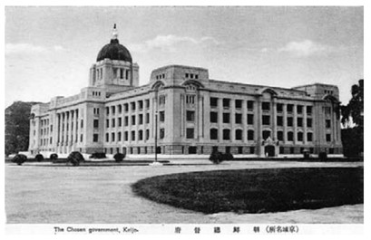
With this understanding, I will now compare three postcards of colonial Korea that, when analysed together, present a narrative of Japanese rule that emphasises colonial modernity. They are taken from the collection “The Views of Keijo.” Originally a 32 postcard set from the 1940s, only 29 of the postcards survive today.[5] The three postcards below all depict colonial Korea, but in dramatically different lights. Lynn argues that known changes to the urban landscape helps to place postcards (that often go undated) in time.[6] For example, the Government General Building in Seoul, Korea, was the subject of many postcards following its construction in 1926, as can be seen in the postcard below:

[7]

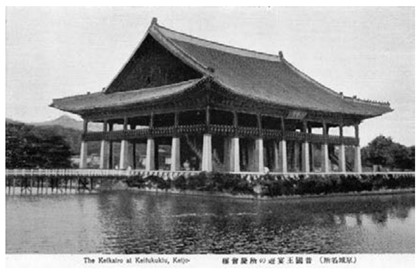
This postcard emphasises the modern architecture of the Government General Building, which sits on the previous site of the Korean Gyeongbok Palace. The demolition of valuable Korean historical and geomantic sites was a key facet of the Japanese occupation. In particular, new and modern Japanese buildings were located strategically and purposefully on old Korean sites. Part of the previous site was often left in ruins alongside the colonial site to demonstrate Japanese superiority.[8] These archaeological areas were then constructed into tourist spots, allowing the Japanese to select a specific representation of premodern Korean culture and civilisation to show the wider public.[9] The second postcard demonstrates this, depicting Gyeonghoeru Palace Hall:

[10]

In the picturing of these two locations in the format of postcards, Japanese forces could demonstrate to the wider Japanese, Korean, and international public their colonial strength and achievements, as well as transforming premodern Korea into a voyeuristic object rather than a lived reality. Combined, this created colonial Seoul as a desirable tourist destination.

In contrast, the third postcard shows the Korean neighbourhood located outside Seoul’s East Gate:

[11]

Postcards such as this, which displayed the thatched roofs of a Korean neighbourhood, helped to reassert a discourse of progress, or lack thereof, through comparison of these spaces with ‘modern’ Japanese buildings.[12] According to these postcards, which were placed alongside one another in a collection, modernity is presented as a result of colonial rule. This narrative implies the upward development of Japanese innovation in comparison to the illustrations of Korean society as in stasis.[13] Furthermore, the Korean people pictured in the postcards become themselves the object of touristic voyeurism and attraction.[14]

“This set of postcards nicely represents three themes typically encountered by Japanese visitors to Korea around 1940, namely examples of modernity introduced by the Japanese, evidence of Japanese efforts to preserve examples of Korea’s “once advanced civilization,” and evidence of the still primitive contemporary native culture.”[15]

Moreover, Lynn argues that colonial postcards “helped portray the colony as a place that was desirable because of its distance, its picture postcard exoticism.”[16] Through postcards, the imagined space of colonial Korea became closer to the Japanese metropole centre, and movement between the two was implied as easily achieved through modern technologies such as ship, rail, and post. At the same time, these postcards painted Korea as consisting of people culturally different (read: backwards) compared to the Japanese people receiving the cards at home.

There are several potential analytical areas around historical postcards which, if developed, would provide further insight into how they are representative of spatial mobility. For instance, the majority of postcards in surviving archival records are cards that remained unsent, likely being donated as a collection.[17] This speaks to the purpose of the cards as beyond simply stationary or for communicative means, suggesting they were tokens worth collecting and preserving. This, however, begs the question; is there more value to those historical postcards which were posted? In terms of examining their mobility, does the act of the postcard itself physically crossing geographical distance (and their rarity now) make it more valuable of study than those which were simply bought and collected? Such questions provide a useful starting point for further academic investigation of the topic.


[1] MacDonald, Kate (2017) Placing Empire: Travel and the Social Imagination in Imperial Japan, Oakland: University of California Press, p. 2

[2] Hyung Gu Lynn (2007) ‘Moving Pictures: Postcards of Colonial Korea,’ IIAS Newsletter, 44: 8

[3] Ibid, p. 8

[4] Ibid, p. 8

[5] Ruoff, Kenneth J. (2010) ‘Touring Korea,’ in Imperial Japan at Its Zenith: The Wartime Celebration of the Empire’s 2,600th Anniversary, Cornell University Press, p. 109

[6] Lynn (2007) p. 8

[7] The Government General Building in Seoul, taken from the collection “The Views of Keijo,” as in Ruoff, Kenneth J. (2010) ‘Touring Korea,’ in Imperial Japan at Its Zenith: The Wartime Celebration of the Empire’s 2,600th Anniversary, Cornell University Press, p. 110

[8] Yoon Hong-Key (1988) ‘Iconographic Warfare and the Geomantic Landscape of Seoul,’ in The Culture of Fengshui in Korea: An Exploration of East Asian Geomancy, Lexington Books, p. 281

[9] Ruoff (2010) p. 109

[10] Gyeonghoeru Palace Hall, taken from the collection “The Views of Keijo,” as in Ruoff, Kenneth J. (2010) ‘Touring Korea,’ in Imperial Japan at Its Zenith: The Wartime Celebration of the Empire’s 2,600th Anniversary, Cornell University Press, p. 110

[11] Korean residential neighbourhood in colonial-era Seoul, taken from the collection “The Views of Keijo,” as in Ruoff, Kenneth J. (2010) ‘Touring Korea,’ in Imperial Japan at Its Zenith: The Wartime Celebration of the Empire’s 2,600th Anniversary, Cornell University Press, p. 111

[12] Lynn (2007) p. 9

[13] Ibid, p. 9

[14] Ruoff (2010) p. 111

[15] Ibid, p. 111

[16] Lynn (2007) p. 9

[17] Ibid, p. 8

Case Studies in World Fair Spatial Configurations

An examination of world fairs of the late 19th and early 20th centuries through a spatial historical lens provides a nuanced perspective on the overlapping cultural and international relations amongst nations at these exhibitions. This blog post will understand these fairs as “networks of exchange” rather than considering each exhibition in isolation.[1] Debra Hanson argues that the fairs, such as the 1851 Great Exhibition in London, initiated a new awareness within the “Western worldview” of the “transnational connections” amongst peoples, cultures, and nations.[2] I argue that this can be further understood through examining the spatial relations between different displays at these events, and in recognising how these relate to the global/local discourse.

David Raizman and Ethan Robey contend that the ‘language’ of material items holds political meaning. Material objects were judged by visitors in comparative terms between different nations and cultures, and politics and nationalistic rhetoric were intertwined with material objects in these fairs. Behind the unified image of peaceful competition presented at these world fairs, Raizman and Robey identify tensions and struggles between different participants, often due to their colonial status. A sort of contradiction can be identified here between image presented and reality:

“…economic competition among participant nations extended outward to supplies of raw materials and workers, and inexorably to colonialism, underpinned by the same military hardware so admired in the exhibition halls.”[3]

Raizman and Robey identify that often national histories were presented through specific narratives in the displays to help define and construct national pride.[4] We can thus identify an irony between many of the displays at these fairs. Whilst the displays of Western nations would present their colonial military ‘might’ in line with developments in technological modernity in the 19th century, the displays of Eastern or Southern (read: colonised) nations would be contrasted to these as a consumable commodity.[5] Nationalisms were communicated through the material objects on display and moulded and shaped in line with these narratives. The spatial relations amongst and between the displays played a part in this, as well as the guidebooks provided to supplement the displays and ensure the visitor followed the set path as they navigated the fair.[6] This defined the exhibitor’s position in relation to the host nation, as well as the observer’s position in relation to the displays and their original imagined locations.

A key example of how the spatial relations of the fairs constructed national narratives is in the 1893 Chicago Exposition. Structured as a classical White City, the buildings of the exposition were arranged in a centre and a periphery, with the Midway Plaisance leading away from the principal buildings. Hanson describes this lay out as a form of “spatial segregation,” as the further away one ventured from the central area the less ‘civilised’ the nations of display were presented to be.[9] Thus, the exhibition constructed a sliding scale of civilisational progress as physically represented by the Midway Plaisance, creating in line with this for the visitors a clear sense of the cultural global centre and periphery in actuality.

A further example of how the narratives of the displays were moulded by colonial influences can be seen in the Tunisian display at the Paris Exposition in 1867. Designed by French architect Alfred Chapon, the ‘Bardo of the Bey’ structure aimed to imitate Ahmed Bey’s summer palace:

[7]

The building adopted past styles and adapted them to contemporary (European) tastes, engaging with the present but preserving practices of the past. The interpretative narrative around the ‘Bardo of the Bey’ is divided. Hanson argues that the structure demonstrates Western management of the East, but for other scholars, it represents cultural negotiation and a physical symbol of hybridity.[8] However, colonial influences were intrinsically bound up in the structure’s creation. The “networks of exchange” occurring at these world fairs thus reflect the orientalist attitudes apparent in their spatial configurations.

Participation in the fairs often led to a construction of a careful, nuanced national past, in order to preserve national unity and political stability. Susan R. Fernsebner explores how a specific national image of “China” was presented by Chinese “expositional managers” (made up of Chinese elites) at various international expositions between 1904-1915.[10] How these elites presented ‘China’ tells us about their own ideas about Chinese nationalism at the time, and highlights the changes to the domestic Chinese political structure in the period. Fernsebner argues that the Nanyang Exposition of 1910 was used to mobilize people in the name of economic nationalism:

“In staging this exposition, Managing Director Chen Qi and his fellow organizers sought to stage a new kind of event for a mass audience in China, one that would help to shape a disciplined population to serve its nation… Organizers framed the ex-position as a studied inventory of the nation’s goods, both for domestic consumption amid foreign competition and export promotion, while placing a growing emphasis on science and industrial production.”[11]

Thus, the exhibitions at Nanyang served a dual purpose: the experience of visiting was painted as a national event to promote economic development, through and in combination with the social indoctrination of Chinese people viewing the displays.[12] Although less to do with the spatial configurations of the displays themselves, this example demonstrates how narrative of nationalism and modernity can be represented physically through material items (such as Raizman and Robey contested earlier on in this post), and how navigation of the physical exposition space affected the visitor phenomenologically.


[1] Raizman, David & Robey, Ethan (2017) ‘Introduction’ in Expanding Nationalisms at World’s Fairs: Identity, Diversity, and Exchange, 1851-1915. Routledge, p. 7

[2] Hanson, Debra (2017) ‘East meets West: Re-presenting the Arab-Islamic world at the nineteenth-century world’s fairs,’ in Raizman, David & Robey, Ethan (eds.), Expanding Nationalisms at World’s Fairs: Identity, Diversity, and Exchange, 1851-1915. Routledge, p. 15

[3] Raizman & Robey (2017) pp. 5-6

[4] Ibid, p. 11

[5] Hanson (2017) p. 15

[6] Ibid, p. 16

[7] Chapon, Alfred (1867) ‘Bardo,’ Pavilion of the Bey of Tunis, Exposition Universelle, Paris, sectional print. Reproduced from Revue generale de l’architecture et des travaux publics, vol. 27 (Paris: Paris Ducher 1869), pp. 35-36

[8] Hanson (2017) p. 27

[9] Ibid, p. 28

[10] Fernsebner, Susan R. (2017) ‘When the local is global: Case studies in early twentieth-century Chinese exposition projects,’ in Raizman, David & Robey, Ethan (eds.), Expanding Nationalisms at World’s Fairs: Identity, Diversity, and Exchange, 1851-1915. Routledge, p. 173

[11] Ibid, p. 178

[12] Ibid, p. 179

Place versus Non-Place

Tim Cresswell’s Place: An Introduction highlights a binary between what can be defined as a ‘Place’ versus a ‘Non-Place’ or placeless-ness. I will analyse that the binary he creates in his chapter, ‘Place in a Mobile World’ is not necessarily one that needs to exist, due to the subjectivity and individuality of the phenomenology of places.

A ‘Place’ can be defined as a heterogenous, dynamic and lively space that is continuously shaped by our social practices and processes.1 He argues that Place is significant to people, and people are significant to the place itself. In other words, Places and people simultaneously create a sense of attachment and historical meaning.2 However, Cresswell discusses that Places have been increasingly homogenised due to increased mobilisation and a consumer society, creating a sense of ‘Placeless-ness’ or ‘Non-Place’3 He describes Placeless-ness as one of inauthenticity, where the average American changes home every three years, reducing the significance of a home. He also uses the example of tourism, where people would rather travel for the sake of it, rather than caring about the actual destination.4

However, Places don’t mean the same thing to everyone: a Non-Place can be seen as a place to someone else. Individuality is taken away in Cresswell’s readings as he over generalises what a sense of place is. For example, in Japan, there is a concept called famirii resutoran or famirsu, meaning family restaurant. These family restaurants are a selection of Japanese, Chinese or Korean cuisines, or even American chain restaurants such as Denny’s, as they “cater to diners of every age, sex and degree of affluence.”5 This seemingly ‘Non-Place’ of a Denny’s, homogenous as it is a chain restaurant, can be perceived as heterogenous due to its unique placement in Japan. A restaurant such as Denny’s is given cultural significance, due to its name and Japan’s history of multiculturalism forming from a “150-year history of industrialisation, nation-state formation and imperialist expansion,” as well as the economic boom in the 1960s.6 Therefore, Cresswell’s binary of Place versus Non-Place is not necessarily true as there are places that seem homogenous on the outside but are actually dynamic places that are imbued with memories and meanings for other people.

Cresswell further highlights this binary through the ‘Disneyification’ of Places. Disneyland is used as an example of a Non-place, where every park is recreated across the world, and thus give the same experience to everyone worldwide. However, even Disneyland can create a unique and individual experience for everyone. When Tokyo Disneyland opened in 1983, it was part of a plan to facilitate more cultural exchanges between Japan and the United States.7 Tokyo Disneyland can be seen as a different experience from American Disneylands because of its different rides, attractions and food. Additionally, due to its sister park, DisneySea. DisneySea is completely unique to Japan with its own theme and attractions that allow people, especially locals, to enjoy.

In summation, the binary of Place versus Non-Place that Cresswell highlights in this chapter does not necessarily exist in its entirety. This is due to individual and subjective experiences in seemingly homogenous places.

  1. Tim Cresswell, Place: An Introduction, 2nd ed., (West Sussex, 2015), p. 68. []
  2. Ibid., pp. 67-69. []
  3. Ibid., pp. 75. []
  4. Ibid., p. 76. []
  5. Katarzyna Joanna Cwiertka, Modern Japanese Cuisine: Food, Power and National Identity (London, 2006), p. 8. []
  6. Ibid., pp. 9-10. []
  7. ‘Grand Opening of Tokyo Disneyland (1980 to 1983)’, OLC: 50th Anniversary, <https://web.archive.org/web/20160304055342/http://www.olc.co.jp/en/50th/03.html> [accessed 26 March 2022]. []

Shanghai’s ‘Underworld’: Considering Crime Spatially

When investigating the history of crime, whether on an institutional or ‘organised’ level, or simply petty thievery, we encounter many oppositions and binaries. Crime exists in opposition to an imposed order. It implies a nonadherence to a set rule. Frederic Wakeman’s article on policing Shanghai in the 1920s and 30s explores the various forces seeking to instil order in Shanghai, which contributed towards its development as an urban municipality.[1] Throughout his article there runs an analytical undercurrent about how crime (considering it as representing an opposition to a desired order) affected urban administrative developments. This in turn influenced Shanghai’s development as a demarcated municipality. In this blog post, I will reject the notion of crime as in complete opposition to policed urban order in Shanghai in the 1920s. I argue that these criminal networks were bound up in the governing processes of Shanghai, both formally and informally. We can better understand the spatial ordering of urban Shanghai, and how this evolved throughout the early- to mid-20th century, by analysing this complex relationship between crime, order, and authority.

The language used when discussing crime in an urban context often constructs a separate location for its occurrence. For instance, presenting the ‘underworld’ of a city, which exists alongside the regular city, provides an imaginary for where crime takes place that is useful to maintain order. Out of sight and out of mind, as it were. This separation allows residents to feel safe in the ordered ‘above-ground’ side of the city, separated from the ‘underworld’ of criminal activities and morally questionable behaviour. Concerning the ‘underworld’ of Shanghai, Wakeman explains:

“Virtually all of these underworld elements belonged to small bands of gangsters called dang or hui that were ruled over by a massive criminal confederation and secret society, originally organized by Yangzi River boatmen, called the “Green Gang” (Qingbang).”[2]

 Wakeman argues that because the Qingbang kept the criminal world of Shanghai ‘in order,’ their activities and existence were tolerated by the International Settlement, French, and Chinese police forces. Many police officers and detectives were associated with the Qingbang or drawn from its membership, as this association was key to performing arrests needed in order to supplement their regular salaries.[3] Already we can observe a complexity in that the Qingbang were instilling an informal form of order within their pursuits as criminals and racketeers. There is order in the coordination of their criminal activities, and thus the notion that crime exists in binary opposition to lawfulness is no longer applicable. Furthermore, we can understand this directly through the influence of crime on Shanghai’s evolution into a municipality.

The power struggle between the central Nanjing government and municipalities establishing their own identities played out through the police and urban order mediums.[4] In Shanghai, both Wakeman and Brian Martin connect these tensions to complex criminal networks through locating illegal activities in the French Concession area. Captain Fiori of the French Concessionary Police (FCP) protected the economic power of Qingbang undertakings, such as in gambling or opium rackets. First, in the early 1920s through instating Huang Jinrong as chief detective, and then in the later 1920s through using Du Yuesheng’s influence to maintain the Concession’s security in the face of national political unrest.[5] Martin argues that the FCP tolerated Du’s racketeering in return for Qingbang aid in maintaining order within the Concession:

“The close cooperation between the French police and Du Yuesheng’s gangsters was officially acknowledged in 1928 by the acting Consul General Meyrier in a dispatch to the French Minister in Beiping. It is probable that the French used the gangster bosses as their intermediaries in establishing contacts with the GMD’s NRA [Guomindang’s National Revolutionary Army], an important element in their strategy to maintain the security of the Concession during the first four months of 1927.”[6]

Through this intertwining of authority, the Qingbang’s crimes become relegated in the public’s imagination to another ‘criminal world,’ not visible to and unaffecting of their safety within the Concession area. In turn, this criminal ‘underworld’ is ordered by the spatial limitations of the collusion that resulted from the complicated relationship between these criminals and the police. An understanding of crime in a binary as solely in opposition to official authority prevents investigation of how illegal activities affected urban administrative developments in Shanghai, which directly contributed to its demarcation as a municipality. Where we historically locate crime, and how visibly it appeared, is affected by recognising these informal expressions of authority in combination with formal institutionalised authority.


[1] Frederic Wakeman Jr. (1988) ‘Policing Modern Shanghai,’ The China Quarterly, 115: 409

[2] Wakeman (1988) p. 414; William T. Rowe (1982) ‘The Qingbang and collaboration under the Japanese, 1939-1945: materials in the Wuhan Municipal Archives,’ Modern China, 8(4): 493-94

[3] Wakeman (1988) p. 415

[4] Ibid, p. 425-6

[5] Wakeman (1988) p. 415; Martin, Brian G. (2020) The Shanghai Green Gang: Politics and Organized Crime, 1919-1937, Berkeley: University of California Press, p. 115

[6] Martin (2020) p. 115

Contested Spooky Spaces

Brenda Yeoh’s chapter ‘The Control of “Sacred” Space: Conflicts over the Chinese Burial Grounds’ in her book Contesting Space in Colonial Singapore: Power Relations and the Urban Built Environment discusses how sacred (traditional) spaces were “eroded away” to make way for a more commercial urban development in colonial Singapore. Because of the British government’s urge to reform cemeteries and their new conscious effort to increase public health standards in the late eighteenth and early nineteenth centuries, the government sought to mirror this in their colonies1 Chinese burial grounds and practices in Singapore were lost to the colonial government because their preference to hillside burial grounds were deemed unsanitary because of the fear that the springs at the bottom of the hill would be poisoned from the decay of the bodies.2 However, this was received by the Chinese as a disrespectful attack over Chinese customs and their own control over their spirituality and sacred spaces.3 Yeoh’s chapter on contested burial grounds has led me to think about other contested burial spaces in other parts of the world.

For example, Japanese burial sites in North Korea, post-World War II are sites that were often ignored, according to Mark Caprio and Mizuno Naoki. There were 71 known Japanese burial sites in North Korea between the 1940s and 50s. However, the number of burial sites and graves are unknown.4 Among the dead were Japanese military (approximately 120,000) and others were refugees from when the Soviet army invaded Manchuria (approximately 70,000).5 These spaces were contested by Soviet officials as they halted plans for Japanese repatriation to further their political movement in Korea.6 This article was highly interesting to read about the political complexities regarding burial grounds. Although, this is one example of a contested space of “enemy” or contested burial sites in East Asia, I would like to research more about the cultural effects of these enemy burial grounds in other contexts.

  1. Yeoh, Brenda S. A., Contesting Space in Colonial Singapore: Power Relations and the Urban Built Environment (Singapore, 2003), pp. 283. []
  2. Ibid., p. 289. []
  3. Ibid., pp. 290-291. []
  4. Mark Caprio and Mizuno Naoki, ‘Stories from Beyond the Grave: Investigating Japanese Burial Grounds in North Korea 悲劇はなぜ起こったか : 朝鮮北部の日本人埋葬地が語るもの’ trans. Mark E. Caprio, The Asia Pacific Journal, 12: 9, no. 5 (March 2014), pp. 6-7. []
  5. Ibid., p. 7. []
  6. Ibid., pp. 8-9. []

Keeping Cool: Investigating Air-Conditioning in South East Asia

The searing heat and high humidity of most of South East Asia (SEA) make it at the best of times, a challenging environment to live and work in. From my personal experience in these perpetual summers, the amount that one sweats simply just from walking is impressive. With salt lines forming down shirts and sweat dripping down arms, the most ubiquitous form of reprieve comes in the form of air-conditioning (AC). When did AC become the norm for many public places in SEA? From trains to shopping malls, restaurants to private homes, they provide comfort for millions every day. The technology and story surrounding AC tell a fascinating story of how people reconceptualised their relationship with the natural environment and how economic factors and the accessibility of technology made cooling through AC commonplace in SEA.

The history behind air-conditioning in South East Asia is the most well documented in Singapore, or at the time the Federation of Malaya. Newspaper clippings from the late 1930s provide a wealth of insight into the trends surrounding air conditioning at the time. The Sunday Tribune, a newspaper that ran between 1931-1951 ran numerous articles extolling the virtues of cool and humidity-free air. [1] Most of the articles pointed to the benefits of comfort in homes and public spaces and even benefits to industry. Despite the generous suggestions that all spaces would soon be air-conditioned, first-hand accounts gleaned from older Singaporeans born before the 1970s suggest that despite the invention of AC technology many decades earlier; It took a great deal of time before they were implemented in the private home. [2] The main reason quoted for this was due to the cost of electricity and the general acclimatisation that many older Singaporeans had to the heat. Fans, open windows and ventilation holes in walls were much more common in private homes during this period.

So, when did air conditioning transition from the public to the home? While the evidence is quite lacking in Singaporean and SEA accounts, a detailed economic study of home AC units based on energy consumption trends in the United States points out a few interesting trends. Jeff Biddle examines the uptake of ‘residential AC’ in the US from the mid-1950s to 1980s and remarks that a change in income, climate, and average electricity rates led to the uptake of AC in homes. [3] One of his key findings was that by the late 1980s the vast majority of Americans had ‘residential AC’. Although the form of economic history he conducts focuses more on macro-economic trends rather than the individual experiences of homeowners, it nonetheless provides a starting point from which we can discuss the uptake of AC in other parts of the globe. One of the key technological improvements Biddle discusses is the competing types of AC, namely central and unit inverters. Where the first required a lot more foresight in terms of installation, the second functioned similarly to any other household appliance and was essentially ‘plug and go’. Essentially the convenience of these inverter units was crucial to the uptake of in-home AC units. The uptake of AC in the home changed the way that people lived quite significantly. Despite its lack of prevalence the possibility in quality of life changes were discussed in newspapers as early as the late 1930s. [4] Taking a public health standpoint, these primary sources cogently pick apart the issues of drastic shifts between indoor and outdoor spaces with the advent of AC.

In the February 10th issue of the Sunday Tribune, the author expresses the concerns of a certain Prof. K. Black, that proposes that the sudden transition from a “refrigerated room” into the tropical heat and vice versa would cause health issues. [5] The author rebukes this claim by arguing that AC merely changes the indoor atmosphere by a few crucial degrees. A claim that is not quite true in the modern-day. Marlyne Sahakian conducted some fascinating research using phenomenological techniques (interviews) to better understand modern societal perspectives and practices regarding AC in the Philippines. In a short section detailing the author’s personal experience as a pregnant woman, she expressed that moving from an intensely air-conditioned room into a warmer space put a strain on her personally. In a few succinct words, “it’s freezing!” she describes the feeling whenever she was in her parent’s or friends’ houses. [6] Sahakian cleverly intersperses these phenomenological accounts (whether personal or other) with solid evidence on historical cooling techniques and the slow evolution of cooling technology in different climates and geographic locations. This sort of social and technological history is precisely what is required in the study of artificial cooling as a phenomenon. Her cogent comments on global standards of ‘comfort’ link well to the existing debates on perceptions of heat and acclimatisation in tropical environments, a topic that is the central debate of Jiat-Hwee Chiang in her book on tropical architecture.

In Jiat-Hwee Chang’s, A Genealogy of Tropical Architecture, she comments on the power dynamics that presupposes many architectural decisions made in SEA. Although her work is at times difficult to understand, she illustrates the key problem of a priori tropicality logic that runs through architectural concepts in tropical environments. [7] Her arguments about these presumptions are quite accurate, but arguably fail to capture the actual human practices that surround cooling. Despite this, Sahakian’s idea that there is a lack of consensus on global standards of comfort synchronises well with Chang’s concepts that ‘tropical architecture’ should not be dominated by western ideas. After all, acclimatisation and adaptation mean that people suited to living in tropical climates perceive heat differently, and buildings and dwellings, should in theory reflect this. [8]

The seemingly hodgepodge of sources presented are but a preliminary survey of accounts that have been gathered in the process of research for a much larger piece of work. The crux of this entire project on cooling rests both on the perceptions of comfort concerning cooling, and how society changed during the period where fans were replaced by AC units. This should raise some interesting questions on changing perceptions of comfort, and the influence that it has had on society. Quite curiously, it also delves into concepts of tropicality, and whether AC supports or subverts its key tenets. Ultimately, a research topic that appears to be worthy of closer examination.

Sources

[1] National Library of Singapore, Reel N1452, Sunday Tribune, entry 10 February 1935, page 10.

[2] Chiang, interviewed by Roger Loh, 8th March 2022, interview 1.

[3] Jeff Biddle, ‘Explaining the Spread of Residential Air Conditioning, 1955-1980’, Explorations in Economic History, 45:4, (September 2008), p. 2.

[4] National Library of Singapore, Reel N1452, Sunday Tribune, entry 10 February 1935, page 10.

[5] Ibid.

[6] Marlyne Sahakian, Keeping Cool in South East Asia: Energy Consumption and Urban Air-Conditioning, (London, 2014), p. 66.

[7] Jiat-Hwee Chang A Genealogy of Tropical Architecture: Colonial Network, Nature and Technoscience, (London, 2016)

[8] Ibid.

Jewish Refugees in Shanghai 1939-1942

From the 1930s, the beginning of the Nazi regime in Germany, there was always Jewish immigration from Germany into Shanghai- the first group of 12 families arriving in 1933.[1] Shanghai was a particularly appealing destination for Jewish refugees from Central Europe was because ‘it is the only place in the world where no entry visa is required’.[2] By Passover 1939, roughly 7000 Jewish refugees were living in Shanghai.[3] There were fears that the Jewish refugees were going to take the jobs of White Russians in Shanghai, and the huge influx of Jewish refugees in 1939 and Chinese war refugees in 1937 made acquiring housing in Shanghai nearly impossible.[4] These factors combined to create an increased pressure from the public to halt free acceptance of Jewish refugees into Shanghai.

The first serious restrictions were passed in August 1939- Alvin Mars uses a quote from the North China Herald, stating that ‘Jewish Refugees arriving in Shanghai after August 21 will not be permitted to live in Hongkew according to a memorandum sent to the committee in charge of Jewish refugees here’.[5] Despite this restriction, the Shanghai Municipal Police (SMP) records between 1939-1941, show an incredible amount of confusion regarding enforcement of Jewish Refugee laws.

For example, the file titled “Letter from the Harbour Master dated June 28, 1940” gives evidence for three separate authorities – the Harbour Master and River Police, Passport Officers and the SMP – arguing over whose responsibility refugee passport checks are. The Harbour Master complains that the SMP is ‘usurping the functions of either Passport Officers or the River Police’.[6] To this, the police report replies that ‘It should be emphasised that the SM Police are not concerted with any other persons than European refugees and that the passports of other persons are not examined’.[7] A further statement made on July 3, 1940 by the offending SMP officer, J.F Lovell, scathingly remarks that ‘the River Police have never shown any desire to “get a move on” when assistance is sought’.[8] There is clear confusion in regards to whose responsibility these passport checks are, and a clear lack of communication regarding whose jurisdiction and authority these checks operate under. Lovell further remarks that ‘the River Police have no conception of the value of the information secured by the Police as a result of the registration of incoming refugees’.[9]


The lack of unity amongst the authorities in relation to the refugees is very possibly the result of the fragmentary nature of Shanghai, in terms of its diverse population, its international settlements, and the authorities in charge of these settlements. This disjointed, unclear system upset many Jewish refugees. A police report titled “Article in North China Daily News Dated May 24, 1940” discusses newspaper clippings containing letters from anonymous refugees criticising the system:

My own application…has been filed since November 1939 without myself having received…notification as to its possible success (…) SMC issues permits on a more lenient scale with the regrettable drawback however, that the validity for some is for four months only’.[10]

However, even here the SMP refuses to take any responsibility for the issues presented in the letter. The report simply states: ‘The contents of the letter [printed in the newspaper] are fundamentally correct but do not reflect in any manner at all upon this office’.[11] Thus, although Shanghai was filled with migrants from China and the rest of the world, this seemed to reflect in a lack of a central authority in law enforcement. This is particularly true in regards to the acceptance of international refugees, which would affect the city as a whole, not simply a single settlement.

Often, the informal immigrant communities – guilds and bangs – were more effective in allowing the SMP to locate immigrants or refugees in Shanghai. In the search for a certain Ero Edmend Rosenfeld this is particularly evident. Though the report does reference their own records, noting the date and ship upon which he arrived- the key piece of information comes from Rosenfeld’s engagement with his Jewish community in Shanghai. As Goodman outlines in her article, immigrants to Shanghai tended to group not only by native place, but also by trade: by extension, businesses of one nationality supported each other.[12] ‘[Rosenfeld’s firm’s] chief business [is] conducted in the sale of boot-polish and a brand of mouthwash, both of which products are manufactured by a German Jewish refugee in Hongkew’, states the report.[13] This information concerning Rosenfeld consolidates his identity as the Jewish refugee the SMP were looking for.

Thus, despite the post-1939 utter lack of organised law enforcement from the legal authorities, the informal communities were much more effective as a system of tracking and understanding Shanghai’s growing community of refugees.


Bibliography:

Goodman, Bryna. “Introduction.” In Native, Place, City and Nation: Regional Networks and Identities 1853-1937. California: California University Press, 1995.

Mars, Alvin. “A Note on the Jewish Refugees in Shanghai.” Jewish Social Studies 31, no. 4 (October 1969): 286–91.

Shanghai Municipal Police Report. “Bernhard Fr-Udenthal – German Jew 2609,” 1940. Shanghai Municipal Police Archive.

———. “Central European Jews – Article in North China Daily News Dated May 24, 1940 2150,” 1940. Shanghai Municipal Police Archive.

———. “Central European Refugees 2144,” 1940. Shanghai Municipal Police Archive.


[1] Alvin Mars, “A Note on the Jewish Refugees in Shanghai,” Jewish Social Studies 31, no. 4 (October 1969): 286.

[2] Ibid, 287.

[3] Ibid.

[4] Ibid, 288.

[5] Ibid, 289.

[6] Shanghai Municipal Police Report, “Central European Refugees 2144” (1940), Shanghai Municipal Police Archive, 1. (Note that all page numbers are PDF numbers).

[7] Ibid.

[8] Ibid, 4.

[9] Ibid, 4-5.

[10] Shanghai Municipal Police Report, “Central European Jews – Article in North China Daily News Dated May 24, 1940 2150” (1940), Shanghai Municipal Police Archive, 2.

[11] Ibid, 1.

[12] Shanghai Municipal Police Report, “Bernhard Fr-Udenthal – German Jew 2609” (1940), Shanghai Municipal Police Archive, 30.

[13] Shanghai Municipal Police Report, “Bernhard Fr-Udenthal – German Jew 2609” (1940), Shanghai Municipal Police Archive, 4.

The Chinese of Colonial Burma

Yi Li’s Chinese in Colonial Burma is an excellent evaluation of the uniqueness of the Chinese communities in Rangoon when compared to other Chinese communities across South East Asia and offers a foundation from which more in depth histories of these communities can be studied. However, a fundamental issue with this history is the absence of the Burmese in the lives of Rangoon’s Chinese. Rather, Yi Li focuses on how the Chinese developed their own individual communities in Rangoon instead of how these communities fitted into the pluralistic social system of the colony.


This absence becomes apparent when in the latter half of the book, focusing on the history of Rangoon, there are fewer than a dozen direct references to how the Chinese interacted with other communities in the town, and they are generally not positive. These include: the bullying of a schoolboy being stereotyped by his classmates; moneylending and pawning to other communities; being the victims of Burmese dacoity; selling opium to other communities; clashing politically with other communities in local government; and by participating in race riots.[1] Essentially, the Chinese in this book are not treated as a part of the community of Rangoon, but rather as one of the communities existing in separation, and often in opposition, to each other.

Fundamentally, Yi Li constructs the importance of the history of these communities as existing in their relationship to colonialism, rather than in their interactions between one another. For instance, the importance of the mercantile reputation of the Chinese was that it placed them in ‘a layer that separated the colonizer and the colonized.’[2] Pairing this with the absence of the Burmese, the experience of the Chinese in Rangoon is mostly depicted as being dependent on interactions with the British. However, while the author lacked the opportunity to include Burmese language sources in their history, there are still ways in which these differing communities’ interactions with one another in the town can be captured through English language sources.[3]

For instance, Yi Li could have expanded on smaller case studies to explore the arguments they make about the Chinese Rangoon colonial experience, and these smaller constituent units’ interactions could then be expanded to include other communities, such as with their discussion on Cantonese woodworkers. While Yi Li emphasises the potential role of Chinese carpenters as agents for the colonial government, and this is evidenced in my own research on the reliance which the colonial government had on their skills to build government buildings such as the lunatic asylum’s dead house in 1880 (their refusal to do so resulting in its construction in brick) and even as late as 1913 when the colony’s wooden road building still almost exclusively employed Chinese labourers, there was a lot more that could be learnt about the Rangoon experience from the representation of these workers in British sources.[4] For instance, when historic laws requiring that newly constructed abodes had to be done so with brick finally began being enforced, the poor quality of the masonry work in the Chinese quarter was blamed on Chinese maliciousness to work around the regulations.[5] However, maps of the town suggest that the Chinese areas of the town had historically fewer brick buildings than other sections, such as the Muslim quarter North East of China Street, and the fact that the British predominantly chose to employ Indian workers led by British engineers for bricklaying work would suggest that this Chinese community, with its legacy of talented carpenters, would produce masonry of a lower quality than in the rest of the town.[6] However, British officials seized on this as an example of Chinese vice and the buildings’ owners were punished, which shows how the historical experience of the carpenters could have been used to further a conversation of how the depiction of Chinese morality by the colonialists impacted the lives of the community.

Although, while this historical moment demonstrates how Yi Li could have broached the other subjects dealt with in this book through a closer examination of this particular economic community, this still only deals with the interactions of the Chinese with the colonial. Instead, the English language sources indicate a number of times in which these workers interacted with the other communities of Rangoon. For instance, due to their expertise in woodworking and their access to transnational tropical wood markets, Chinese carpenters held a monopoly on the production of gharry carriages.[7] How the Chinese craftsmen negotiated the prices of these carriages with the drivers who belonged to other communities not only had a significant impact on the livelihoods of these two types of workers, but also affected the spatio-temporal experience of the town. In 1907-1908, the cost pressures of gharry-driving were worsening as not only were they having to pay for new licenses but the scarcity of the seasonal wood used to construct them was increasing. Accordingly, fares began increasing, and this was part of the process that had encouraged the replacement of gharries with rickshaws, although the rickshaws were imported from abroad, presumably since they were not historically native to Rangoon.[8] So here is an example of how the exploration of this one aspect of the Chinese community can be linked to a wider story of Rangoon which is shared by all of its inhabitants. Gharries became too expensive to make and run, and so not only were they replaced by a cheaper form of transportation, but this put the Chinese gharry makers and the gharry drivers from other communities at financial risk, demonstrating the delicate economic ecosystem which encompassed all the town’s communities.

Indeed, such analysis on the interconnection between the Chinese carpenters and the wider transportation economy of the town could lead to alternative perspective on the community’s history. For instance, while Yi Li uses the account of one Chinese columnist to explain that the Chinese community’s attacks against Chinese rickshaw drivers was due to their desire to self-construct an image of a Chinese merchant character, it could instead be more likely that the introduction of the rickshaws came at a very sensitive time when the Chinese community were losing business due to the importation of foreign-made rickshaws.[9] Additionally, such explorations could be taken further as this was not just an economic story, because the switch to rickshaws over gharries would have had a fundamental effect on how everyone in the town experienced its spatio-temporal aspects, as a rickshaw alters the hierarchies of who can and cannot afford private transportation, it also effects the experience of riding as well as the hierarchies between those being transported and the transporter or the people walking in the streets. Such notions are also suggested by Noel Singer who wrote a much more general history of the town.[10] Therefore, such analysis can reveal not only how the Chinese inhabited this space, but also helped form its nature while being a part of it along with the town’s other communities.


However, this is just an example of how the use of English language sources can unveil much more about how different cultural communities interact with one another in a space beyond their interactions with the colonial. By focusing at greater length on the smaller cases of those within a community, such as Cantonese carpenters, Yi Li could have written a history that emphasised how these people’s lived experiences were not just located in Burma, but were also the products of its interconnected society. However, if Yi Li’s aim was to examine the construction of a Chinese community in isolation from the interactions which different members of this community had with the wider town, then it still serves as an excellent history.

[1] Yi Li, Chinese in Colonial Burma: A Migrant Community in a Multiethnic State (London, 2017), 127, 135, 156, 158, 199-205, 206.

[2] Ibid., 111.

[3] Ibid., 12.

[4] Report on the Rangoon Lunatic Asylum for the Year 1880 (Rangoon, 1881), 1; Appendix to the Report of the Public Works Department Reorganization Committee: Vol. III (Calcutta, 1917), 3.

[5] Report on the Working of the Rangoon Municipality for the Year 1909-10, (Rangoon, 1910), 16.

[6] Plan of the Town and Suburbs of Rangoon (London, British Library, Cartographic Items Maps I.S.136), map by F. L. Seaton (Calcutta, 1880), 5.

[7] Report on the Working of the Rangoon Municipality for the Year 1907-08 (Rangoon, 1908), 14.

[8] “Rickshaws in Rangoon”, Eastern Daily Mail and Straits Morning Advertiser, Singapore (7/11/1907), 3, <https://eresources.nlb.gov.sg/newspapers/Digitised/Article/easterndaily19071107-1.2.24?ST=1&AT=search&k=rangoon%20tram&QT=rangoon,tram&oref=article> [accessed: 24/02/22].

[9] Li, Chinese in Colonial Burma, 138.

[10] Noel F. Singer, Old Rangoon: City of the Shwedagon (Stirling, 1995), 137.

Policing Indian Nationalism in Shanghai

The rise of transnational revolutionary anti-colonialism also oversaw the diversification of the duties of policing. Shanghai provides a case study of how urban policing transformed the rising pressures to survey, monitor and police rising anti-colonialism. Section 4 of the Shanghai Municipal Police Force (the Indian branch) is an interesting focus of study as its formation signalled the diversification of the duties of the Indian police force in Shanghai. Their position became more than just an economic method of asserting British colonial authority. The Indian police force became involved in the wider movement to suppress anti-colonialism across the British empire, demonstrating how urban policing became connected to the wider network of anti-colonialism. 

Reports from Section 4 division highlight the worry of anti-colonialism amongst the Indian population, influenced by the rise of Chinese nationalist groups during the 1920s and the narrative of pan-Asianism supported by the growing Japanese empire in China.1 A notable fear comes from members of the Ghadar movement who were arriving from the United States and Canada to expand their influence to Indian populations across the empire.2 The Sikh and Indian population formed a core of the British military forces globally, and the influence of anti-colonial sentiment could fracture the British military structure.3 These fears become evident with reports in the Shanghai Municipal Police Archives demonstrating a need to increase surveillance of ‘seditious Indians’ across Shanghai.4 Surveillance includes that, ‘In all cases, however trivial, involving Indians it is essential that the names of the paternal parents and villages of births to be obtained’ with all information forwarded to the detective constable.5 The reports highlight a developing insecurity of the wider Indian population and their connections to anti-colonialism, warranting the need to increase population surveillance. 

These insecurities highlight the diversifying role of Indian police officers in Shanghai. The 1927 construction of the Section 4 branch occurred out of awareness of rising Indian revolutionary movements in Shanghai and the need to suppress those movements. Indian police officers are viewed as valuable due to their ability to speak the local languages of Indian nationalists, their existing experience in police and detective work and their’ most comprehensive knowledge of local Indian affairs’.6 The new branch and the officers’ new position highlight the transitioning role of Indian police officers as agents of anti-colonial suppression. 

New duties of the special branch included collecting intelligence and border security. Their increased responsibilities in policing unravel surprising insights on the extent of surveillance collected on the Indian population in Shanghai. By 1936, the Special Branch held 2000 photographs and 1000 biographies of Indian ‘seditionaries and sympathisers’ residing in Shanghai.7 This included a comprehensive collection of individual names, photographs, family histories, ancestral homes in India, passport numbers and registration numbers. 8 The nature of the information collection demonstrates a need to easily identify suspects, establish connections of individuals to other revolutionary groups and track their travel history. This is starkly different from policing trends of 1930 that detailed the need only to survey newly arrived Indians from North America residing within International Settlement Districts.9 By 1936, surveillance methods expanded beyond the geographic jurisdiction of the Shanghai Municipal Police and towards any member of the Indian population, including students, professionals and travellers.4 It demonstrates how the insecurities held by governmental forces altered the role of Indian officers to become intelligence officers for the British. 

An additional role of the Special Branch included the enforcement of border security. Movement was an important aspect of surveillance as the 1937 report from the special branch detailing new procedures for the emigration of Indian nationals back to India. The processes included an arduous procedure of consultation with both the consulate and the special branch. To travel, the national would be required to fill out documents and submit them to the special police branch and once approved, the branch (under instruction from the consulate general) would allow the individual to purchase a ticket.10 Finally, the consulate would issue a certificate authorising the national to travel.7 The procedure highlights two factors. Firstly, the need to have police surveillance over the movement of Indians demonstrates the insecurities held by the British government of the increasing rise of transnational anti-colonialism and the need to prevent its spread to other corners of its empire. Secondly, the diversified role of Indian police officers in monitoring and controlling Indian movements in and out of the city.

Intelligence and border control are only two elements of urban policing connected to suppressing anticolonialism. However, the blog post is attempting to highlight how the transformatory role of the Indian constable demonstrates the wider relationship between urban policing and colonial security. British insecurities of rising anticolonialism transformed a municipal police force into a transnational intelligence agency.

  1. Shanghai Municipal Police, Section 4, Indian Section, Special Branch, February 11 1936, Special Branch Sections: Organisation and Work 1929-1941, File No. D.8/8, p. 22. []
  2. Ibid., p. 24 []
  3. Isabella Jackson, ‘The Raj on Nanjing Road: Sikh Policemen in Treaty-Port Shanghai’, Modern Asian Studies 46: 6 (November 2012), pp. 1697-1700. []
  4. Shanghai Municipal Police, Indian Section, p. 24. [] []
  5. Shanghai Municipal Police, Police Order No. D. 6679, Indians Arrested at Stations, December 24 1936, Special Branch Sections: Organisation and Work 1929-1941, File No. D.8/8, p. 8. []
  6. Shanghai Municipal Police, June 21 1929, Special Branch Sections: Organisation and Work 1929-1941, File No. D.8/8, p. 49. []
  7. Ibid. [] []
  8. Shanghai Municipal Police, Indian Section, pp. 24-27. []
  9. Shanghai Municipal Police, April 29 1930, Special Branch Sections: Organisation and Work 1929-1941, File No. D.8/8, p. 41. []
  10. Shanghai Municipal Police, Indians: Emergency Certificates to India, May 10 1937, Special Branch Sections: Organisation and Work 1929-1941, File No. D.8/8, p. 12. []