China Political Reports: British perspective on Sino-Japanese relations

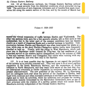
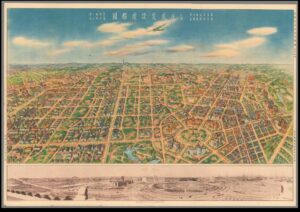
It is interesting to look into the China Political Reports from the years of the Japanese establishment of Manchukuo, not only to provide an outsider’s perspective into Sino-Japanese relations, but also to analyse how the railway was used as a non-military method of control, and how railways were used by the British to interpret the often secret negotiations between China and Japan. The extracts analysed are taken from China Political reports from two volumes: Volume 4, containing reports written between 1928-32, and Volume 5 written between 1933-36. These were confidential documents, written by two British diplomats as part of the annual reports on China, for use of the foreign office. The first extract is from the 1932, the year Japan established Manchukuo, discussing the year’s impact on the Chinese Eastern Railway. It was telegrammed to Sir John Simon in Britain from Mr. Ingram, a British consul in China. The source describes how the Chinese Eastern Railway suffered the most during these years because of anti-Japanese sentiments, bandits along the eastern sections of the line, and floods, which resulted in the suspension of traffic between Harbin and Vladivostok, two major Russian railway towns. Meanwhile, the Southern Manchurian Railway (SMR) “borrowed and surpassed” Russia’s railway plans and insisted that the SMR’s facilities were the most modern available (Buck, 75). This leads to Mr. Ingram’s hypothesis that “it is at least possible that the Japanese do not regard the paralysis of the [Chinese Eastern Railway] as an entirely unmixed evil”- it is the main competitor of the SMR as well as the “cornerstone of Russian influence in North Manchuria”. The implications of this are that with the Chinese Eastern Railway weakened; the Japanese could continue exerting their influence in Manchukuo. If, as Buck frames it, Changchun represented the “inland extension of a foreign-dominated treaty port”, then the railways were the key to exerting control in a place without direct outright military action (Buck, 65). The Japanese gained control first through the railway, and then through the establishment of a government of Manchukuo.


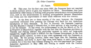
The next set of extracts is from Sir Alexander Cadogan to Sir John Simon as part of the annual report on China in 1934, two years following the establishment of Manchukuo. 1934 also marked the first year since 1930 that “the Japanese have not resorted to direct military action to gain any objective in China” (p.278). Cadogan then goes on to speculate that because it would be a blow to Chinese public opinion to have any outright agreements with Japan, the two countries have been conducting their affairs “gradually and without any publicity” (p.270). Many of Cadogan’s interpretations are based on analysis of the railway traffic going between Manchukuo and China: it is in this way that China was able to negotiate a relationship with Japan without needing to publicly recognise the government of Manchukuo. The railway and the towns attached to them become important levers in establishing a peaceful relationship between the two countries.


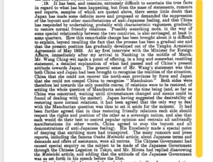
A further report on the “subsequent developments in the general political situation between China and Japan” (p.331) were provided by Cadogan again on May 17, 1935. He states, with hints of personal annoyance, that it is “difficult to ascertain the true facts in regards to what has been happening” (p.336) between China and Japan, and that China was acting “with characteristic vagueness” (p.336) to meet Japanese demands and restore normal friendly relations. Cadogan’s annoyance here is probably indicative of the increased secrecy of negotiations between China and Japan, and an increased reliance on railways, infrastructure, and other elements of modernisation to protect Japan and China from Western aggression (245, Louise Young). Young argues that the railway exemplified just one method of building modernity within Japan and its empire, without needing any assistance from the West. Cadogan goes on to describe the “long and somewhat rambling statement” of the Minister of Foreign Affairs Wang Ching-wei, stating that both China and Japan have seemingly set aside the question of Manchukuo. Meanwhile, Japan was determined to increase the Japanese population in Manchuria while planning a highly ambitious development programme for their new territory, including the development of the railway, highways, air transport and communications networks (Tucker, 53). Japan would continue exerting control over Manchukuo through its commercial drive: by the end of 1936 there were countless Japanese shops, restaurants, hotels and other small businesses in railway towns throughout Manchuria (Young, 254). This is evidence that Japan was continuously asserting its dominance in Manchukuo, and that China was appeasing these demands, without the need for overt military force from either side. So, it is through no coincidence that these foreign reports on Sino-Japanese relations rely on railways and other commercial agreements to speculate on what diplomatic agreements were being reached by both countries- they often reveal more than official military or diplomatic discussions.


Bibliography:


‘Mr. Ingram to Sir John Simon: Annual Report, 1932’, in Robert L. Jarman (ed.), China Political Reports 1911-1960, Vol. 4 (Chippenham, 2001), pp.640-1.


‘Sir A. Cadogan to Sir John Simon: Annual Report 1934’, in Robert L. Jarman (ed.), China Political Reports 1911-1960, Vol. 5 (Chippenham, 2001), pp.269-336.


Buck, David D. “Railway City and National Capital: Two Faces of the Modern in Changchun” in Railway City and National Capital: Two Faces of the Modern in Changchun, pp.65-89.


Tucker, David “City Planning Without Cities: Order and Chaos in Utopian Manchukuo” in Mariko Asano Tamanoi ed., Crossed Histories: Manchuria in the Age of Empire, pp.53-81.


Young, Louise, Japan’s Total Empire: Manchuria and the Culture of Wartime Imperialism, Twentieth-Century Japan (Berkeley, Calif: University of California Press, 1999), “Brave New Empire: Utopian Vision and the Intelligentsia” pp.241-268.

Government-General Responses to Flooding in Keijo and French Indochina


            Although separated by over three thousand kilometers, Korea and the area formerly known as French Indochina (Cambodia, Laos, Vietnam, and Guangzhouwan China) share similar weather, and every year for roughly a month they endure a monsoon season. Today, the potential dangers of these monsoons are adequately eliminated as a result of modern infrastructure, which did not appear out of the blue. In the early twentieth century in Japanese colonized Korea and French Indochina, officials began concerning themselves with city planning regarding flooding caused by monsoons. Although preventing flood damage was not the only goal in mind, this piece will focus specifically on the different approaches taken by the Japanese and French Government-General in order to solve issues of flooding.

            In Assimilating Seoul: Japanese Rule and the Politics of Public Space in Colonial Korea, 1910-1945, Todd Henry analyzes the Japanese Government-General’s attempts to transform Keijo, modern day Seoul, into “Great Keijo.”1The Japanese Government-General had an underlying goal in the creation of a “Great Keijo.” Henry explains that Japanese officials sought to create a ‘showcase city’ of Japanese modernity.2 In other words, city planning in Keijo was a demonstration of Japan’s civilized status to the West; city planning prioritized image over function. With this in mind, flooding issues in Keijo was of little concern to the Japanese Government General. Henry reveals that by 1912 citizens of Keijo expressed concerns regarding monsoon flooding of the Hanh River.3 Japanese officials responded with a multitude of short term solutions which inevitably failed. According to Henry, city planners mostly ignored these flooding issues until a flood in 1925 which caused roughly four hundred deaths and forty-six million yen in property damage.4 This event finally brought the issues of flooding to Japanese officials’ attention; unfortunately, Henry indicates that “the Government-General continued to pursue its own plans to transform Keijo into a showcase city.”5 From Henry’s analysis of the Government-General’s efforts in flood prevention, it can be seen that in the city planning of the ‘Great Keijo’ Japanese officials were concerned with validating their position as a ‘civilized’ nation rather than the function of their plans.   

On the other hand, France was already considered ‘civilized’. As a result, the French Government-General in Indonesia’s city planning efforts were concerned with function over image. In 1912, Jules Sion writes about the major importance of rainfall in the lives of the native population, and consequently rainfall in the French Indochinese territories must be scientifically studied.6 Sion’s article addresses the negative aspects of the shutting down of rain measuring stations in French Indochina. He argues that, given the importance of rainfall for the Indochinese population, rain measuring stations must be re-opened for scientific research; more importantly, he emphasizes that rainfall must be measured in order to prevent destructive flooding.5 Additionally, Sion acknowledges the urgent necessity of building roads and railways, but the absence of rainfall measurements will lead to inevitable missteps.7 Evidently, Sion is advocating for the reopening of rainfall measurement facilities in order to benefit nation building and infrastructure construction. Moreover, in 1930, Charles Robequain also discusses the importance of rainfall measuring stations in French Indochina; however, this time, it is to discuss the positive efforts of the Government-General. In accordance with Sion, he insists on the insufficient number of rainfall measuring stations in Indochina in 1912, and that the development of rainfall measuring stations would limit the destruction of floods.8 He fortunately reveals that at the end of 1928 the number of functioning rain stations were 338, as opposed to only 150 in 1926.5 This swift re-opening of these stations by the French Government-General highlights the prioritization of flood prevention by French officials.


By comparing the efforts of French and Japanese officials in flood prevention, it is evident that they had disparate goals. While Japanese officials ignored the needs of flood preventing infrastructure in order to assert themselves in the ‘civilized’ world, the French saw the rain’s destructive ability and established stations which gathered scientific data in order to predict future meteorological destruction. Admittedly, rain played a different role in both spaces. In Indochina, understanding rainfall was not only important to prevent destruction, but it was also paramount in growing its mostly agricultural economy. Nonetheless, while the Japanese Government-General focused its city planning on the impression it would make on the world, the French Government-General implemented stations in order to aid the Indochinese population.


Bibliography:

Primary Sources:

Robequain, Charles, ‘Le climat de l’Indochine française’ Annales de Géographie, 39:222, 1930, pp. 651-653

Sion, Jules, ‘Les Pluis de L’indochine’, Annales de Géographie, 21:120, 1912 pp. 462-464

Secondary Sources:

Todd A. Henry, Assimilating Seoul: Japanese Rule and the Politics of Public Space in Colonial Korea, 1910–1945, (California Scholarship Online, 2014)


  1. Todd A. Henry, Assimilating Seoul: Japanese Rule and the Politics of Public Space in Colonial Korea, 1910–1945, (California Scholarship Online, 2014), p. 42 []
  2. Todd A. Henry, Assimilating Seoul: Japanese Rule and the Politics of Public Space in Colonial Korea, 1910–1945, (California Scholarship Online, 2014), p. 31 []
  3. Todd A. Henry, Assimilating Seoul: Japanese Rule and the Politics of Public Space in Colonial Korea, 1910–1945, (California Scholarship Online, 2014), p. 47 []
  4. Ibid []
  5. Ibid [] [] []
  6. Sion, Jules, ‘Les Pluis de L’indochine’, Annales de Géographie, 21:120, 1912 p. 462 []
  7. Ibid p.464 []
  8. Robequain, Charles, ‘Le climat de l’Indochine française’ Annales de Géographie, 39:222, 1930, p. 653 []

Architecture as an indicator of the Alien: The Rangoon Lunatic Asylum

Rather than the intellectual justification of the construction of European architecture in Asian colonies being a celebration of grandeur and cultural superiority, for the agents of the state actually on the ground, often their justifications could simply be due to the practical limits of their situation. Taking Rangoon’s asylum as a case study, we can see that the British were struggling to build the institution as they had hoped, and this was in large part due to the noncompliance of the colony’s population.

While the City Beautiful movement would be embraced across the British Empire a few decades after as a way of securing the permanence of British colonial superiority, as suggested by Robert Home and Peter Hall, and even at the time when the French were building European architecture across Indochina as an expression of their cultural superiority, as argued by Gwendolyn Wright, the superintendent of the Rangoon Lunatic Asylum was considering the use of European architecture in 1880 for a very different reason.[1] Ever since the institution had opened in 1871 there had been attempts made by the administrators of the facility to construct a dead-house within its compounds. While this had initially been a request which was not acted upon with much urgency, by the end of the decade death rates were equalling roughly 10% of the asylum’s population as epidemics and the general debilitation of the patients who had remained in the asylum for a number of years started to impact on the numbers dying, and so the asylum’s superintendent attempted to act upon this issue.[2] However, there was one particular obstacle which he encountered:

‘The dead-house, which was asked for eight years ago, has not yet been erected. The money for a wooden structure has been long ago sanctioned; but the Burmans and Chinese decline to build it, because, as they say, men and women are cut up in it. To get over this difficulty it was suggested that it should be built of brick.’[3]

While this statement does not provide any illumination as to why the construction of the dead-house out of brick would be a way of circumventing the issues facing the superintendent, we can provide a suggestion as to why this may be the case by examining the other buildings within the compound. As a way of housing the non-criminal inmates, the asylum offered a number of wooden cottages, and these cottages would be raised above the ground by poles, the reason for this being that during the monsoon rains it would keep the structure away from the groundwater and prevent them from rotting or dampening the interior.[4] We could suggest, therefore, that the only workers who knew how to build this particular kind of raised structures with the wood particular to that area of the world were the populations who had lived and built towns in the area for generations: the Burmese and Chinese. Therefore, the suggestion to construct the dead-house with brick as a response to these populations’ refusal to build it out of wood could be an implicit suggestion that the superintendent must now rely upon other populations present in the town, probably the Indian labour force, who would be under the instruction of a British engineer, who presumably had no knowledge as to how to construct these buildings with these materials as they would have lacked the cultural knowledge which the local geography had made necessary.

This surely was a setback for the British colonial agents as not only were brick buildings more expensive to construct than wooden ones, but also the previous superintendent had praised how effective the local architecture was at providing easily cleanable and good quality housing for the inmates, helping to keep their disposition from turning violent, and the superintendent quoted above lamented as to the ineffectiveness of the asylum’s brick buildings at keeping the rains out of the cells.[5] This is just one example of how the attempt to impose British ideas as to how the state should respond to mental health were rejected by local cultures. Other examples include when the local populations resisted providing payment for the care of their friends and relatives incarcerated within the asylum, and they also resisted requests from the asylum’s authorities to return escaped patients, who were only returned once the asylum’s staff happened upon these individuals in the town by chance, but neither of these other two incidents were exhibited through the architectural presentation of the asylum.[6] Now, however, the inability to convince the local populations to embrace European conceptions of medical practices as a part of their culture was now visually represented. Not only were the practices within the building alien to these cultures, but, due to this act of resistance by local builders, so was its façade, making the distance between the British and the people whom they were trying to govern obvious to all, and leaving this failure of the asylum’s administration, with all of its implications for its future running, as a mark upon the layout of the facility.

[1] Robert K. Home, “Miracle Worker to the People” in Of Planting and Planning: The Making of British Colonial Cities (1996) Peter Hall, “The City of Monuments” in Cities of Tomorrow: An Intellectual History of Urban Planning and Design since 1880 (2014, 4th Ed.); Gwendolyn Wright, “Indochina: The Folly of Grandeur” in The Politics of Design in French Colonial Urbanism (1991).

[2] G. D. Burgess, Report on the Rangoon Lunatic Asylum: For the Year 1880, (Rangoon, 1881), p. 17.

[3] Ibid., p. 1.

[4] G. D. Burgess, Report on the Rangoon Lunatic Asylum: For the Year 1879, (Rangoon, 1880), p. 1.

[5] Ibid., p. 1; G. D. Burgess, Report on the Rangoon Lunatic Asylum: For the Year 1880, p. 1.

[6] G. D. Burgess, Report on the Rangoon Lunatic Asylum: For the Year 1879, pp. 4, 8.

Spatial Alienation: The Expulsion of the Chinese in Colonial Batavia

Within Henri Lefebvre’s work, The Critique of the Everyday, alienation is introduced as a tool of political and economic exclusion of the lower classes.[1] He critiques how the design of Paris came to exclude the non-elites by driving them further away from the city centre, creating an increasingly disruptive and distant space between their domesticity and their place of work.[2]

The exclusivity of the town centre and the alienation of the other represents a politicisation of space that is exemplary in formal colonial town planning processes. Peter Hall demonstrates how the most formalised application of alienation was Luyten’s Delhi, as the city was reimagined and reorganised under a complicated hierarchy of race, social rank and affluency.[3] Those who ranked in the upper echelons of British colonial society remained in the centre while the less affluent and local residences were pushed outwards. The new city centre was a symbol of British political power, and the city was to be remodelled as an Eastern Rome.[4] This new Eastern Rome arguably applied only to areas of European domesticity, recreation and work as the Indian outskirts did not fall under formal town planning processes other than their physical distance to the central metropole.


Much like Delhi, Batavia (modern-day Jakarta) also represents spatial exclusion but in a less formalised manner. The 1750 map of Batavia created by Jacques Nicolas Bellin demonstrates the alienation of the other in his representation of Batavia’s inner and outer city.[5] The map was created after the 1740 Batavia Massacre that saw the expulsion of the Chinese Batavian population outside the city walls.[6] Although they were allowed back into the walls, a sizable Chinese settlement was already formed called Glodok, directly south of the city walls.[7] The placement and representation of Glodok exemplifies Lefebvre’s notion of spatial alienation as it is applied as a tool of political and economic exclusion of the lower classes.

The placement of Glodok outside the city walls is the primary symbol of exclusion as the wall creates a physical barrier between the European and the Chinese populations.[8] From Bellin’s map, it appears that Glodok also became alienated from the formal Dutch town planning processes. The map demonstrates a stark difference between the constructions of the two districts. The inner walled city is planned in a grid-like structure with wide streets and large housing. Space is abundant, and infrastructure for transportation such as bridges between canals are frequent between blocks. Glodok appears dense with smaller plots of housing organised in a non-grid like structure. Districts are constructed to fit the geographical shape of the land in between the southern walls and the Ciliwung River. Streets appear to be narrower, and bridges between rivers are less frequent. The physical representation of Glodok highlights an alienation of the Chinese population outside both the city walls and outside the formal town planning processes of the Dutch.

Spatial alienation also appears representationally as Bellin’s map highlights a dominant trend amongst most cartographic representations of Batavia during this time period.[9] Maps are arguably political, they can be an inclusionary tool as they represent physical space for a wider audience. However, they can also be exclusionary as cartographers can oversimplify or exclude space from their representation. Bellin’s 1760 construction of Batavia follows a clear trend of exclusion as it provides a detailed representation of each district, street and river within the city walls as it represents the European community’s domestic, recreational and professional space.[10] However, Glodok and areas outside of the city walls remain anonymous. Glodok fails even to be labelled while the settlements east and west of the city walls are identically produced illustrations of plantations.[11] Outside the periphery of the European community, Glodok appears as a dead space, negligible in terms of individual agency or political and economic activity.

Although Bellin’s map is not representative of Chinese or Javanese lived space, it is valuable in presenting the effects of spatial alienation in colonial cities. Alienation appears in two forms; it exists as a physical and representational act of exclusion as it demonstrates a space that lives outside the European periphery.


Bibliography:

Primary Sources:

Bellin, Jacques, Plan de la Ville et du Chateau de Batavia (1750). Image in Bartelle Gallery (BG-11199), <https://bartelegallery.com/product/map-of-batavia-bellin-1750/> [accessed 9th October 2021].

Krevelt, A.V. Peta Batavia 1780. Image in Batavia Digital <https://bataviadigital.perpusnas.go.id/peta/?box=detail&id_record=10&npage=1&search_key=&search_val=&status_key=&dpage=1> [accessed 9th October 2021]

Pemerintah Kolonial Belanda, Peta Batavia 1672. Image in Batavia Digital <https://bataviadigital.perpusnas.go.id/peta/?box=detail&id_record=15&npage=1&search_key=&search_val=&status_key=&dpage=1> [accessed 9th October 2021].

Surjomihardjo, Abdurrachman. Peta Batavia 1650. Image in Batavia Digital, <https://bataviadigital.perpusnas.go.id/peta/?box=detail&id_record=14&npage=1&search_key=&search_val=&status_key=&dpage=1> [accessed 9th October 2021]


Secondary Sources:

Hall, Peter. Cities of Tomorrow: An Intellectual History of Urban Planning and Design since 1880 (New York, 2014).

Jingga, Fanny and Yulia Nurliani Lukito, “Ethnic Identity and its response to the growing environment in the urban space of Glodok, Jakarta.” AIP Conference Proceedings Online Volume 2376, issue 1 (2021), pp. 1-6.

Lefebvre, Henri. The Critique of Everyday Life Volume I (New York, 1948).


[1] Henri Lefebvre, The Critique of Everyday Life Volume I (New York, 1948), p. 148.

[2] Ibid., pp. 229-230.

[3] Peter Hall, Cities of Tomorrow: An Intellectual History of Urban Planning and Design since 1880 (New York, 2014), pp. 212-223.

[4] Ibid., p. 212.

[5] Jacques Bellin, Plan de la Ville et du Chateau de Batavia, (1750).

[6] Fanny Jingga and Yulia Nurliani Lukito, “Ethnic Identity and its response to the growing environment in the urban space of Glodok, Jakarta”, AIP Conference Proceedings Online Volume 2376, Issue 1 (2021), pp. 3-4.

[7] Ibid.

[8] Bellin, Chateau de Batavia.

[9] Bellin, Chateau de Batavia; Abdurrachman Surjomihardjo, Peta Batavia 1650, (Batavia Digital); A.v. Krevelt, Peta Batavia 1780 (Batavia Digital); Pemerintah Kolonial Belanda, Peta Batavia 1672, (Batavia Digital).

[10] Bellin, Chateau de Batavia.

[11] Ibid.

Tour Guides and Films: A look into the Spanish-American War in the Philippines

The Spanish-American War fought between two imperial powers, each disputing over Spanish colonies and the entitlement of land against native wishes, brings about some interesting sources. Looking at mainly primary sources written and spoken in English, specifically American-published sources regarding the Spanish-American War, it seems that Americans were initially trying to paint a picture as if they were non-belligerent and were only involved in the war because the Spanish coerced or pushed them to war. Films that were published highlight Americans were forced into the war after damage to their naval ship, the U.S.S Maine, exploded by a Spanish mine on Havana Harbour, implicitly connotes Americans as non-belligerent as “[they] did not start it!”. However, this was not necessarily true as time went on. In the Philippines, films and tour guides paint a slightly different picture of Americans as belligerent actors against “native” Filipinos, as they try to assimilate the Philippines into their domain after the Treaty of Paris (signed on December 10, 1898). Therefore, I will argue that films and tour guides implicitly display American agendas of either being non-belligerent actors in Cuba and after the Treaty of Paris was signed (which gave the United States the Spanish colonies of Cuba, Puerto Rico, the Philippine Islands, Guam and the West Indies), they pursued a more imperial doctrine of conquering and ‘assimilating’ Filipinos through violent means.

The first film to be discussed is a panning shot of the USS Maine destroyed by a Spanish mine on the Havana Harbour in Cuba, which ultimately led to the Spanish-American War.[1]

https://www.loc.gov/item/98500970/?

The film pans across the ship’s side to see that the ship looks ‘cut in half’, caused by an explosion. The film depicts a ‘sad loss’ of naval soldiers as the ship took countless lives. The explosion ignited a gunpowder keg of tension between the Spanish administration in Cuba and the United States. This film provides a source of documentation that not only shows us the damage by the Spanish administration but highlights the power that one act can set off a year of belligerence and brutality.[2]

During the war, Philippine Insurgents worked together with American Imperial forces against the Spanish colonisers. However, as the battle drew to a close with the Spanish forces, and after the Treaty of Paris was signed in December (which led the United States to buy the Philippine Islands from the Spanish), American forces decided to ‘benevolently assimilate’ the Philippines into their domain ‘by any means necessary’.[3] One film that highlights American belligerence is below:

https://www.loc.gov/item/98501198/?

This film shows some Filipinos retreating from American infantry after a few were gunned down. The brutality of the war is depicted here, highlighting the imperial doctrine Americans embraced to control the Philippine Islands eventually.[4]

Another clue into Americans’ brutality and their Imperial objectives are in a tour guide published in 1899. The tour guide ‘notes’ section implicitly depicts the American colonisation process. The “extraordinary circumstances” that led to the guide not mentioning a few details, including “residents of American and Spanish authorities”, are something not to be missed in this guide. The lack of studied areas in this guide also implicitly depicts that those areas were used for war and possibly other gruesome acts.[5]

In conclusion, these primary sources are nuggets of clues that indicate American objectives in the Spanish-American War. Initially, a film was produced to show Spanish damage to the U.S.S Maine. After the Treaty of Paris was signed in December 1898, the American objective changed into an imperial role of assimilating the Philippines as one of their colonies; brutally taking down Filipino men and massacring tens of thousands of civilians in the process.

[1] Paley, William Daly, “Wreck of the Battleship ‘Maine’”, Thomas Edison Inc. (United States: Edison Manufacturing Co, 1898). <https://www.loc.gov/item/98500970/?>

[2] ‘Chronology for the Philippine Islands and Guam in the Spanish American War’, The World of 1898: The Spanish-American War, (Library of Congress, 2011). https://www.loc.gov/rr/hispanic/1898/chronphil.html

[3] Ibid.

[4] James H. White and New Jersey National Guard, ‘Filipinos retreat from trenches’, Thomas Edison Inc. (United States: Edison Manufacturing Co., 1899). <https://www.loc.gov/item/98501198/?>

[5] Manila Guide For Foreigners: A Useful Book for All, (Manila, 1899).

Painting Reality: Utopian Visions of Shinkyo Under Japanese Administration.

An authoritative score of road networks spans out in front of us; a pleasingly rectangular stamp on a colourful blue-sky background. This is Shinkyo. But if we adopt Michel de Certeau’s argument that a bird’s eye view of a city is inadequate and instead search for the spatial “acting out” of the city, does the “tour” of Shinkyo correspond with its “map”?[1]

In 1932, the Japanese developed a planning proposal which saw the Manchurian town of Changchun transformed into the visionary city of Shinkyo (also Xinjing) and represented the zenith of Japanese industrialisation and competition with the West. The city was developed closely in line with the ideals of the Japanese Guandong Army who had occupied Manchuria, and who prioritised state planning, economic domination, and a unified and obedient public.[2] The proposal included regular street layouts, European-style squares, parks, grand central buildings, and industrial domination. Notably, these developments occurred alongside the increasing importance of the South Manchurian Railway (SMR) which was imagined as the vehicle which would propel Shinkyo into a modernity beyond the access of the West.

The map (see below) was published in 1936 by the State Capital Construction Bureau of the State Council of Manchuria.[3] It is a bird’s eye view of Shinkyo, showing the construction plan with detail of individual streets, monumental centres, railway lines and shrine complexes. It is accompanied by a photographical print of the building progress on the city to that date. The publication of this map by the State Council is valuable in revealing the ideology of spatial reconstruction in Manchuria. The map is striking for its obvious grid pattern. Goto Shimpei, the SMR’s first president and contributor to the planning proposal for Shinkyo, was influenced by European city planning in Germany and subsequently introduced the idea of wide streets and zoned areas according to commercial, residential or commemorative function.[4] The map enhances the impression of this functional zoning by elevating the viewer so that the grid pattern is more pronounced and we adopt the view of the planner or architect who works on the landscape as if it is an operational subject. It implies that the planned vision of Shinkyo was developed independent of the realities of the Manchurian landscape or environment- the plan is flat, the planner has had no need for confrontation with mountains or freezing temperatures. Indeed, the grid pattern on the map fades off to the edges, where the landscape continues as a flat, blank canvas. Historians have categorised this as the utopian “blank page”, planning that only existed on paper.[5] It reveals the desire of Japanese authorities to spatially reconfigure a previously Chinese space into a new centre of Japanese modernity and industrialisation, without any cultural or social challenges. It suggests that city planning during the early 20th century adopted a unique “space-time conception”, where physical construction of roads, monuments and shrines could inaugurate a new era of progress that only Japan could access.[6]

This utopian vision of the future is seen in the detailed features of the map- uniform illustration of housing and additions of minute, unspecified people. This artistic representation disseminated as propaganda suggests that the planners had “free reign of creative vision” and did not include the reality of social structures within the lived city, a vision which filtered down into popular conception of Manchuria. It is true that the uniformity of their plan in some ways translated into reality. Shinkyo did become a hugely efficient commercial centre as the designation of certain spaces for economic and agricultural activity meant that the connective function of the SMR could be fully exploited, for example in the expansion of the soybean trade.[7] However, the static uniformity of the plan does not equate to the reality of 20th century Xinjiang. Even the photograph, evidenced alongside the drawing of the map as if to ratify the existence of the hexagonal dream, is taken before people are included into the equation of the city plan. The uniform housing excluded the presence of the Chinese, who were designated as the enemy, and consequently disrupted the utopia with the erection of immigrant houses on the outskirts of the city. This diverged from the Japanese-style housing and temples assigned on the map. Moreover, cottage industries (largely run by the Chinese) prospered, alongside the domination of the Chinese in banking and moneylending. A tarnish to the vision of a collective Japanese modernity. The map’s neglect of Chinese and Russian commercial districts is compounded by the tiny brushstroke figures we see pounding the streets. They are orderly and unidentified- they pose no social or nationalistic threat to the new Japanese modernity as they are all the same.

The lofty birds eye view of the map, whilst not representational of reality, is valuable in its suggestion of Japanese planning as a means to “scientifically manag[e] energy” in the newly acquired territory of Manchuria to create a distinctly Japanese space.[8] Whilst De Certeau rejected the engineered “concept city”, in the study of 20th century Japan, it becomes valuable for its insight into social and political aspirations.[9] City planning often involved the rejection of real forces of social and environmental change, but created an entirely new space in the administrative imagination- an uninhabited utopia where order and dominance could be asserted through spatial categorisation and management.


Bibliography

Primary Sources

Manshukoku Kokumuin Kokuto Kensetsukyoku, Kokuto Kensetsu Hansei Chikashi (Map of Shinkyo), (China 1936).

Secondary Sources

De Certeau, Michel, The Practice of Everyday Life, (California 1985).

Esherick, Joseph, “Railway City and National Capital: Two Faces of the Modern in Changchun”, in Joseph Esherick (ed.) Remaking the Chinese City: Modernity and National Identity, 1900-1950, (Hawaii 2000), pp.65-90.

Tucker, David, “City Planning Without Cities: Order and Chaos in Utopian Manchukuo”, in Mariko Asano Tamanoi (ed.), Crossed Histories: Manchuria in the Age of Empire, (Hawaii 2005), pp.53-82.

Young, Louise, Japan’s Total Empire: Manchuria and the Culture of Wartime Imperialism, (California 1988).


[1] Michel De Certeau, The Practice of Everyday Life, (California 1985), p.98, p.118.

[2] Joseph Esherick, “Railway City and National Capital: Two Faces of the Modern in Changchun”, in Joseph Esherick (ed.) Remaking the Chinese City: Modernity and National Identity, 1900-1950, (Hawaii 2000), p.65.

[3] Manshukoku Kokumuin Kokuto Kensetsukyoku, Kokuto Kensetsu Hansei Chikashi (Map of Shinkyo), (China 1936).

[4] Esherick, “Railway City”, p.74.

[5] David Tucker, “City Planning Without Cities: Order and Chaos in Utopian Manchukuo”, in Mariko Asano Tamanoi (ed.), Crossed Histories: Manchuria in the Age of Empire, (Hawaii 2005), p.60.

[6] Tucker, “City Planning Without Cities”, p.63.

[7] Ibid, p.70.

[8] Esherick, “Railway City”, p.81.

[9] De Certeau, The Practice of Everyday Life, pp.95-6.

The Ownership of Barracks: Regimentation made Resistance

Space is rarely an asymmetrical imposition of power which all agents are subjected to equally. This is a very crude and underwhelming statement, but it is one whose implications we should always remind ourselves of when adopting new historical approaches. Those implications are drawn out much more elegantly by Michel de Certeau who, in one of the critiques he aims at Michel Foucault in L’invention du Quotidian, characterises the Foucauldian perspective on space as perceiving it as a part of a structure of power.[1] Space, in this understanding of Foucault, becomes a tool from which systems of power may better categorise, hierarchise, and discipline society into conformity. These dichotomic divisions of society ‘draw their efficacy from a relationship between procedures and the space that they redistribute’[2] in order to deepen the chains of significations that reaffirm the logic of these categorical separations. In other words, our relative understandings of where we position ourselves in relationships of power are conceptualised spatially and are reinforced through spatial practices.

What de Certeau offers as an alternative to this argument is a realm in which the individual agent escapes the structuralising nature of ordered space through ‘multiform, resistance, tricky and stubborn procedures that elude discipline without being outside the field in which it is exercised.’[3] In drawing out the implications of this position, we open up broad new approaches to history in which we can frame past events as belonging to a process of resistance and individuality, rather than one of inevitable and encroaching control and repression; essentially, giving agency back to the agent. Furthermore, by looking at the historically constant and individualised reappropriations of spaces, we can see how disordered spatial practices can snowball and perhaps undermine the structuralising effects which the hierarchical relationships of power that ordered spaces attempt to create could have on other individuals. In this instance, we can use the example of Rangoon to justify this statement.

Twenty years after the conquest of Rangoon, its restructuring upon a gridiron system, and its bureaucratisation as the colonial capital of British Burma, the British colonial authorities decided to conduct a census across the entirety of their Burmese territories in 1872.[4] Rangoon had been planned by the British using a similar model to other colonial cities they had planned, relying upon centuries of intellectual refinement from the “grand modell”, and, as a consequence, Rangoon resultingly shared many of its demographic features with these similarly planned Asian cities: a multicultural and polyglot population, as well as a significantly imbalanced gender ratio.[5] However, As this census would suggest, the urban techniques that the British had used to assert their bureaucratic and cultural power across the globe were not so effective an apparatus of power as they would have believed.

In the census report’s section focusing upon the enumeration of towns, the report’s author states that it was ‘the easiest work of all’ and that it was mostly ‘taken in one night.’[6] “mostly” is the operative word here, since the report’s author emphasises that there was the significant ‘exception of Rangoon Town.’[7] What occurred in Rangoon is described by its town magistrate as thus:

‘The night of the 15th was a fine night; and, with a hope of securing correct numbers, &c., of the cooly classes who live in barracks and lodging-houses of various kinds, I instructed the Police, and had the Inspectors told off to superintend the work during the night. The Assistant Superintendent of Police, the Assistant Magistrate, and myself went about the town to exercise general supervision. We then witnessed the great want of legal authority in the work, for in some of these barracks, &c., the people pretended to be asleep, and not to hear the order of the Police to open their doors and bring lights. All was darkness, and the Police dare not resort to force. Delay ensued, and it was found quite impracticable to carry out my original intention; I was therefore obliged to cause the forms to be checked by sending Police and enumerators round the town for a week to test the accuracy of the forms, and make corrections.’[8]

In other urban spaces, such as the mostly natively constructed Thayetmo, no such issues were encountered and the colonial authorities could impose much more aggressive tactics due to the effectiveness of their enumeration, including the detention of boats trying leave or enter Thayetmo on the night of the 15th of August.[9] Instead, by refusing to wake up, the low wage, contracted, potentially even indentured labourers who had been housed in regimented communal living spaces, perhaps by the town authorities or the capital interests that they were serving as a way of reinforcing their economic and social positions in the city’s hierarchy, were appropriating these spaces as places of their own rest and security, and they therefore felt no need to comply with the disciplining attempts of the state’s agents. Rather than being spaces of order and compliance, these people used these spaces to reposition their relative proximity to the state and its control over them. This simple act of sleeping and the bravery to not answer the door was enough to change the nature of the census, warping it from a comprehensive survey being imposed upon them outside of working hours, to a rough survey which was conducted around their work schedules for their convenience. By resisting attempts to be categorised by the state through sleeping in their beds, the repressed of Rangoon restricted the state’s ability to enforce future policies within this city space due to the more greatly inaccurate abstract conception of the demographic makeup of the city’s population that colonial authorities now had. Due to this assertion of agency and ownership from the bottom-up, the people within this urban space, which was designed to order and control them to a greater extent than those urban spaces which, in actuality, ended up being more compliant, resisted the degree of hierarchisation of this new colonial space that the colonial authorities wanted to impose.

Space played a vital role in this small moment of history, but it was a role of resistance which those self-empowering individuals chose to give it, rather than one of control and imposition.

[1] Michel de Certeau, The Practice of Everyday Life (University of California Press, 2011), 96.

[2] Ibid.

[3] Ibid.

[4] H. T. Duncan, Report on the Census of British Burma: Taken in August 1872 (Rangoon, 1875).

[5] Robert K. Home, “The ‘Grand Modell’ of Colonial Settlement” in Of Planting and Planning: The Making of British Colonial Cities (1996), 9-37.

[6] Duncan, Report on the Census of British Burma, 3.

[7] Ibid.

[8] Ibid.

[9] Ibid.

Surgical Treatment of Organic Space: The Reconstruction of Seoul under Japanese Rule (1910-1945).

The Japanese Annexation of Korea in August 1910 prompted a rebuilding of Korean urban space under a Japanese state ideology. The Government-General worked to physically change the city of Keijo in particular, in order to mentally transform the identities of Korean colonial subjects in a project of assimilation. In his publication Assimilating Seoul: Japanese Rule and the Politics of Public Space in Colonial Korea, 1910-1945, Todd Henry describes the desacralisation of the Korean Royal House, state planning projects involving roads, harbours and street layout, government building construction and the alteration of sacred spaces.[1]  These were state-building colonial projects that sought to imbue Korea with a Japanese self-confidence in nationalism. The project of spatial reorganisation is recorded in Japanese government reports of the early 20th century which document the progress of urban construction in contrast with the “history” of Keijo and its inadequacies.[2] These reports are valuable in revealing the ideology behind spatial planning, but also in their more surprising corroboration with Henry’s argument that Japanese spatial organisation was not all subsuming.

The Annual Report on Reforms and Progress in Chosen, 1921-22, begins with a narrative on the history of civil engineering in Korea, bolstering the journal’s later claims of progress and innovation through a contrast with pre-colonial Korea. “Public properties were in a most neglected state and subject to abuse by the people”.[3] This implies that the state of Korean cities caused a disunity and lack of respect among their citizens, who are depicted as aggressive and barbaric. The attack on the physical stature of the city implies that the identity of Korea was being destroyed internally, consequently presenting the construction work of the Japanese as the rebuilding of national identity. This is ideology is evident in examples such as the Keijo City Planning Research Association which was established in 1921. The organisation placed emphasis on the scientific management of space to create an organic urban system which simultaneously overcame ethnic and class divisions.[4] This displays the ideological vision which is exposed in the Annual Report of 1921 that Korean society was a malleable entity which could become part of a larger Japanese nationality through their integration into the physical environment of the city. Consequently, the development targets for roadbuilding and harbours which the Annual Report mentions can be seen as part of a project to maintain an unbroken Japanese imperial line across borders. The historical report of conditions prior to colonial occupation describes roadbuilding as an “unknown science…preventing economic and cultural development”.[5] This further elevates the Japanese role as one of ‘saviour’ implying that they facilitated the emergence of Korea onto an international stage. This did occur as newly developed roads and other transportation networks facilitated lowered transport costs and the development of integrated market systems.[6] On the level of town planning, however, road development acted as a both a physical and metaphorical entity which cut through the ancient Korean past and reshaped the city as a focal point of modernity- “straightening, grading and widening” streets.[7]

However, in his publication, Henry suggests that the ideological development of Korean cities was not always successful, and that the Japanese ability to integrate Japanese and Korean citizens was “highly variable and partial”.[8] This was a result of the human ability to add additional layers of meaning to a space, which, observed through the analytical lens of Lefebvre, became a space of social struggle.[9] The Annual Report corroborates this, despite its celebratory tone. In road building “resort[ing] to the old custom [was] allowed only in the case of third-class roads, as these were closely connected with local interests”.[10] This implies that investment was concentrated at a central level, meaning that first and second-class roads which connected with the city centre and Japanese quarters were prioritised. It suggests that central planning was orientated toward the Japanese presence, resulting in uneven development and neglect of the smaller, local “capillary networks”.[11] Indeed, in the report, these local areas remain associated with an unsophisticated Korean past, implying that Japanese development projects were far from total or all-subsuming, supported by the statistic presented by Henry that 85.5% of Keijo retained its pre-colonial administrative boundaries.[12]

The Annual Report provided by the Japanese administration is valuable in revealing the ideology behind the physical transformation of Korean cities after its annexation. The 1921-22 report demonstrates the use of derogatory Japanese visions of old Korea in elevating their own colonial projects of improvement. Moreover, it demonstrates the use of town planning as both a physical and mental tool which was used to reshape and define Korea under Japanese terms of nationalism. This source is useful when examined alongside secondary literature such as Todd Henry’s Assimilating Seoul which assesses the limitations of Japanese town-planning as an ideological tool without practical implementation on all social levels.


Bibliography

Primary Source:

Government-General of Chosen, Annual Report on Reforms and Progress in Chosen (Korea), 1921-22, (Korea 1923), pp.159-167 <https://archive.org/details/annualreportonreformsandprogressinchosen korea192122/page/n203/mode/2up> [accessed 27th September 2021]

Secondary Sources:

Caprio, Mark, Japanese Assimilation Policies in Colonial Korea, 1910-1945, (Washington 2009).

Henry, Todd, Assimilating Seoul: Japanese Rule and the Politics of Public Space in Colonial Korea, 1910-1945, (California 2014).

Merrifield, Andy, Henri Lefebvre: A Critical Introduction, (2006).

Pao-San Ho, Samuel, ‘Colonialism and Development’ in Kenneth Pomeranz, Dennis O Flynn, Arturo Giraldez (eds), The Pacific in the Early Age of Industrialisation, (London 2009), pp.347-398.


[1] Todd Henry, Assimilating Seoul: Japanese Rule and the Politics of Public Space in Colonial Korea, 1910-1945, (California 2014), pp.28-32.

[2] Government-General of Chosen, Annual Report on Reforms and Progress in Chosen (Korea), 1921-22, (Korea 1923), pp.159-167.

[3] Annual Report on Reforms and Progress in Chosen (Korea), p.159.

[4] Todd, Assimilating Seoul, p.45.

[5] Annual Report on Reforms and Progress in Chosen (Korea), pp.159-160.

[6] Samuel Pao-San Ho, ‘Colonialism and Development’ in Kenneth Pomeranz, Dennis O Flynn, Arturo Giraldez (eds), The Pacific in the Early Age of Industrialisation, (London 2009), p.352.

[7] Annual Report on Reforms and Progress in Chosen (Korea), p.162.

[8] Todd, Assimilating Seoul, p.6.

[9] Andy Merrifield, Henri Lefebvre: A Critical Introduction, (2006), p.115.

[10] Annual Report on Reforms and Progress in Chosen (Korea), pp.159-160.

[11] Todd, Assimilating Seoul, p.37.

[12] Todd, Assimilating Seoul, p.37.

Churches in Manila: A Start to the Long Essay

As I am thinking about potential topics for the Long Essay due in December, I have stumbled upon some interesting thoughts, two to be precise: the empirical versus the theoretical.

Firstly, a potential topic for my essay would be the discussion of Catholic spaces and general Catholicism brought into the Philippines by Spanish conquistadors versus Protestantism (and possibly other non-Catholic Christian religions) and Protestant spaces brought into the Philippines by Americans.

During my brief research, I found that the first Protestant minister, Arthur Prautsch, served as a missionary in Manila in 1899. He became a local preacher for the Methodist church in Manila for a Bishop named James M. Thoburn. Shortly after this, more missionary groups followed, and by 1916, the Methodists had “50 missionaries and 45,000 converts”, the Presbyterians had 65 missionaries with 15,700 members by 1925, the Baptists had 2,858 converts in 1925, and finally, the Disciples of Christ and the Foreign Christian Mission Society became the “third-largest non-Catholic church in the Philippines with 7,326 members” by 1925.[1]

I found the empirical research, the growing number of followers for Protestant religions to “save” Filipino’s from the “unchristian” and “corrupt” Latin Catholicism highly fascinating. The missionaries’ goal to “save” Filipinos by “preaching the Gospel and erecting churches” became noteworthy for me due to the concept of the “Church” versus churches.[2] This brings me to my second thought, the theory.

The churches built by Protestant missionaries are actual physical spaces. The spaces are physical landmarks where people interact with the space. People go inside a church; they sit on pews and listen to a sermon, light some candles, and they talk and interact with others (to be honest, I am not a churchgoer, so the technicality of what someone does in a church is still a bit lost on me). Nevertheless, what provoked me, is not just the physical space of a church; it is the concept. The Catholic Church versus the Protestant Church. The capitalisation of the letter ‘C’. The discourse surrounding it is a representation of the space rather than a representational (lived and interacted with its physicality) space. In my understanding, Lefebvre’s triad Churches are multi-dimensional spaces, and the way it is talked about can be considered just as powerful as a physical space or building.[3] The conceptualised idea of a Church holds just as much power as the actual building of a church; the conversations held around the Catholic Church versus the Protestant Church. For example, how the Protestant Church found Roman Catholics and its clergy “wealthy and corrupt [whom they] failed to promote morality, closed the Bible to the people, and based the faith also on tradition and not just on holy scripture.”[4]

To summarise my contemplations, I believe this could be an exciting topic of study for my Long Essay, with primary sources ranging from plans of churches to the discourse surrounding Churches. However, it seems quite convoluted, and the topic needs further deliberation.

[1] Jose S. Arcilla, ‘Review: Protestant Missionaries in the Philippines’, Review of “Protestant Missionaries in the Philippines, 1898-1916. An Inquiry into the American Colonial Mentality” by Kenton J. Clymer, Philippine Studies, 36: 1 (1988), p. 106.

[2] Ibid., pp. 106-107.

[3] Henri Lefebvre, The Production of Space (xx, 1974), pp. 38-39.

[4] Arcilla, ‘Review: Protestant Missionaries in the Philippines’, p. 109.

Malacca: Internal Diversity and the Homogenisation of the Malayan National Identity

The first chapter of Reading Bangkok explores the historical origins of Bangkok from the fall of the Ayutthaya kingdom towards the early 20th century. Ross King’s primary argument lays upon the idea that Bangkok (and by extension, Siam) holds a dualistic identity, a surface level (masked) identity and an internal identity.[1] Bangkok’s ethno-religious diversity of Buddhist Thai, Lao, Khmer, Muslim Patani, Christian-Portuguese and Chinese serve the foundation of Bangkok’s internal identity, not predicated on any singular ethno-religious background. While on the surface, rigid and homogeneous notions of a singular ‘Siamese’ identity upheld barriers to distinguish the local from the foreign in the name of European-inspired ‘modernity’.

I would argue that this phenomenon of masking diversity is evident in other cities of Southeast Asia, namely Malacca (and, by extension, Malaysia). The colonial administration encouraged the construction of separate and rigid ethno-religious identities, providing them the agency to define the parameters of a grand ‘Malayan’ identity.

Sin Yee Koh highlights that Malaysia’s ethno-religious diversity has been masked by a rigid Malay-centric vision of Malaysian identity.[2] Unlike Siam, this surface-level identity has not been applied through local, elite-driven movements towards ‘modernity’ but by British-driven efforts to homogenise Malaysia’s diverse population under an anglo-centric understanding of ‘Malayan identity’.

This is exemplified in Thomas Newbold’s 1839 Political and Statistical account of British Settlements in the Straits of Malacca, namely, Malacca. Newbold acknowledges Malacca’s ethno-religious diversity, however, it appears that his census has inconsistencies with broadly constructed identities that appear to segregate and simplify the city’s population. Newbold incorporates the diverse peninsular Malay, Acehnese, Moluccan and Bugi population under a broad Malay category.[3] But at the same time, he produces a specific ‘Javanese’ category despite its similar origins to the broadly defined ‘Malay’ ethnic group.[4] Additionally, Newbold includes both broad religious and ethnic groups within his census to categorise people of unidentifiable or fluid backgrounds. Those with South-Asian ancestry that do not fit under the ‘Chuliah’ or ‘Bengali’ categories were identified as ‘Hindoo’.[5] Those who were not identified as ‘European’ but followers of the Christian faith (no matter what ethnic group) fit under the broad Christian category.[6]

This census highlights two ideas. Firstly, the colonial administration failed to provide agency to Malacca’s internal diversity and created broad categories that compartmentalised the city’s population for easier administration. Secondly, the desire for simplification highlights a highly rigid notion of identity, one that disregards demographic fluidity for concretely define categories of identification.

The colonial administration was arguably not blind towards Malacca’s internal diversity as Newbold does acknowledge local Eurasian populations. However, this fluidity is disregarded as a form of ‘impurity’. The Portuguese-descent population, which have resided in Malacca for 400 years and are highly inter-mixed with the peninsular Malay and Chinese populations, are regarded as ‘degenerated’ and ‘impoverished’.[7] However, the Dutch population are deemed ‘respectable’ due to their ‘pure’ lineage to elite officers of the previous Dutch colonial government in Malacca.[8]

As the colonial administration engaged in the segregation of Malacca’s demographic diversity, this provided ample agency for the administration to construct an understanding of a broader ‘Malayan’ identity. Newbold creates a dichotomous relationship between the ‘native’ and the ‘foreigner’, with the peninsular Malay population labelled as ‘native’ and all other populations seen as ‘foreign’.[9] This constructed identity removes agency from the domestic population and provides power to the colonial administration to define Malayan identity for themselves.

Koh’s analysis supports this as the colonial administration’s assertion of what it meant to be ‘native’ constructed a national identity that emphasised the importance of the ‘native’ Malay over the ‘foreign’ Chinese and Indian population.[10] Much like in Siam, a homogenous identity masked Malaya’s internal demographic diversity under rigid definitions of race and religion, emphasising the indigenuity of a native ‘Malay’ population as the primary representation of Malayan identity. The ‘mask’ of the ‘native’ dominated nationalist politics and arguably dominates local Malaysian politics today.


Bibliography:

Primary Source:

Newbold, Thomas John, Political and Statistical account of the British Settlements in the Straits of Malacca, viz. Pinang, Malacca and Singapore; with a History of the Malayan States on the Peninsula of Malacca, vol. 1. (London, 1839).

Secondary Sources:

King, Ross, Reading Bangkok (Hawaii, 2011).

Koh, Sin Yee, Race, Education and Citizenship: Mobile Malaysians, British Colonial Legacies, and a Culture of Migration (New York, 2017).

[1] Ross King, Reading Bangkok (Hawaii, 2011), p. 1.
[2] Sin Yee Koh, Race, Education and Citizenship: Mobile Malaysians, British Colonial Legacies, and a Culture of Migration (New York, 2017), pp. 88-89.
[3] Thomas John Newbold, Political and Statistical account of the British Settlements in the Straits of Malacca, viz. Pinang, Malacca, and Singapore; with a History of the Malayan States on the Peninsula of Malacca, vol. 1. (London, 1839), p. 136.
[4] Ibid.
[5] Ibid., pp. 136-137.
[6] Ibid.
[7] Ibid., p. 138.
[8] Ibid., pp. 137-138.
[9] Ibid., p. 44.
[10] Koh, Mobile Malaysians, pp. 88-89.