Hong Kong and the Grand Model

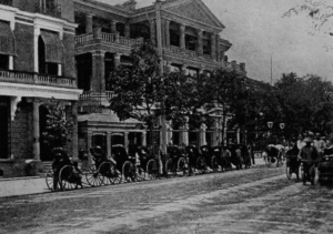
Hong Kong stands alongside Singapore, Bombay and New Delhi as being one of the most well known and defining spaces of the British colonial enterprise in Asia. But unlike the aforementioned cities, Hong Kong is unique in its relatively late date of colonization, being ceded to the British in 1841. This places the city in a rather unique period in terms of British colonial urban planning – the ‘Grand Model’ that had dominated the approach to colonial urban planning was reaching the end of its over two centuries long tenure.[1] Towards the end of the 1840s, arguments that favored a hands off laissez faire approach to urban planning would prevail, and remain dominant going into the tumultuous 20th century.[2] In short, Hong Kong represents a unique opportunity to evaluate the principles and practice of the ‘Grand Modell’ at its most developed point – and while the Australian city of Adelaide can provide a similar example,[3] the character of the British colonial project in Australia is sufficiently different to warrant another example. Where in the British colonial projects in places like India and China had relatively powerful and well organized local communities and governments that they were forced to engage with in some way, the Indigenous communities of Australia were systematically excluded and in many cases destroyed.

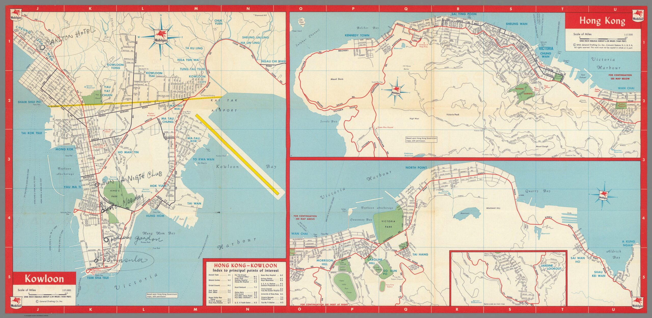
To aid this analysis, a map of Hong Kong from 1958 produced for the American Mobilgas company[4] will be used. The reasoning for the use of this particular map is twofold. Firstly, being produced in the late 1950s, the urban environment of Hong Kong has had time to develop, but the pressures of the World Wars and Great Depression would have made the prospect of any new urban designs at best difficult to implement. Secondly, the map being of an American origin lends it an advantage – while it is obviously far from an extremely accurate, unbiased presentation of Hong Kong, it is disconnected from the immediate context of the British and the systems of British colonial administration. It also clearly has a utilitarian purpose, most likely being used by tourists – meaning it is less likely to be a rendition of how Hong Kong ‘should be’ – at least from an urban planning perspective. One important limiting factor that should be mentioned is that the map only covers a small space of Hong Kong – mostly the areas enclosing Hong Kong bay, while the New Territories, Sai Kung, a significant portion of Hong Kong Island and Kowloon have been excluded from the map. The map is also not suitable for discussing the third and fourth principles of the Grand Model that Robert Home describes – we cannot use a map intended for consumption by tourists to give us an insight into whether or not Hong Kong was laid out in advance, nor can we use it to determine the exact size of the many main roads marked on the map[5].

https://www.davidrumsey.com/luna/servlet/detail/RUMSEY~8~1~299701~90070709:Kowloon–Hong-Kong-

The first principle of the Grand Model as defined by Robert Home is ‘deliberate’ urbanization – in short, strong central authorities prominent throughout or dominating the urban landscape.[6] This principle is displayed in the Mobilgas map of Hong Kong, especially on Hong Kong Island itself – the organs of the colonial administration (government offices, post office, police headquarters, barracks) are clustered around two major roads, Queen’s Road East and Queen’s Road Central, while roughly lying in the center of the urban build up on Hong Kong Island.[7] They also sit in close proximity to the ferry piers that are essential for travel between Hong Kong Island and Kowloon.[8] It should be mentioned however that this principle does not appear to be as strongly applied to Kowloon – while there is a post office and railway station sitting at the south end of the central Nathan Road, there is little else in the way of administrative organs or buildings symbolic of the British colonial administration on the mainland – something that seems strange at face value given the seemingly larger scale of the urban environment in Kowloon.[9] In short, the principle of deliberate urbanization in Hong Kong has been partially followed.

The second principle defined by Robert Home is that of land rights allocated in clearly differentiated regions of town, suburban, and country lots, something that Home describes as being definitively tied into the program of deliberate urbanization.[10] Where the previous principle is displayed in the 1958 urban landscape of Hong Kong, this principle is completely absent. Hong Kong, as displayed in this map, is a nearly totally urban environment, with the few suburban locations having no distinct boundary between themselves and the urban, and the country being not present at all.[11] The majority of the northern Hong Kong Island displayed on this map is an almost uninterrupted urban sprawl following tightly along the coast line, running from Kennedy Town to North Point, only interrupted by Victoria Barracks and the naval dockyard.[12] The inset displaying Jardine Lookout has an identifiable suburban structure with small winding avenues and roads, but is directly connected to the bustling urban environment north of it by the Happy Valley Race Course and Stubbs Road[13]. The layout of Hong Kong Island appears to have more in common with the concept of a treaty port and opposed to a colonial township. Meanwhile, the section of Kowloon displayed on this map is a wall of urban space that seemingly sheers off straight into nothing north of Clear Water Bay Road, Tai Po Road, Kowloon Tong and Kowloon Tsai.[14] It is worth mentioning that the limitations of the Mobilgas map as a source are apparent in this discussion – as mentioned before, it only covers a small region of Hong Kong, leaving out for example, the fishing villages of Sai Kung, and the expanse of the New Territories. Its purpose as a guide for American tourists may also be a limiting factor – with most of the interest of the map on the urban spaces of Hong Kong, the mapmakers may have simply not bothered to describe in detail the non-urban spaces of Hong Kong. However, even with those caveats in mind, it is reasonable to conclude that there is at the very least a lack of a consideration for the principle of differentiated regions of urban, suburban and country displayed in Hong Kong. This discussion also ties into the eight principles discussed by Robert Home, being that of a clear green space separating the town and the country – for the reasons already discussed above, it is fair to conclude that this principle was also at the very least disregarded.[15]

The fifth, sixth, and seventh principles laid out my Robert Home – respectively, that of a rectangular, grid based plot layout, the presence of public squares, and the reservation of plots for public purposes[16] can also be discussed in sum, as they are intertwined with each other due to the condensed nature of Hong Kong’s urban environment. To start, Hong Kong does display a rectangular grid layout, but not a standardized one.[17] While Hong Kong’s plots are nearly rectangular across the board, all flowing from a main road, they are not standardized, with many subsections of the urban space having different orientations and sizes for their plots – compare, for example, the rectangular layouts flowing out from the nearly parallel Nathan Road and Ma Tau Wei Road in Kowloon[18]. These layouts are also interrupted at several points by public places – typically gardens, that seem to be centrally located ala a public square[19]. For example, Southorn Playground in Wan Chai lies at the center of the urban space surrounding Hennessy Road, but in doing so interrupts the standardized grid plots surrounding Hennessy Road and Queen’s Road East.[20] A more prominent example is that of King’s Park, lying at the center of Kowloon – King’s Park does not conform to any kind of grid layout, and indeed represents a significant break from the sprawling grid layout to its east, west and south.[21] Taken in sum, I argue this represents an adherence to the spirit of the relevant principles, but does not follow them strictly to the letter. The grandeur and symbolism of a public square at the center of the city is not present, instead with public parks taking their place – spaces of leisure but still symbolic – the name ‘King’s Park’ is in itself symbolic, especially considering it is in the center of the Kowloon urban environment. A grid based layout is present, but its shape and form shifts across the landscape, serving more as a loose guide opposed to a strict commandment. The only principle of the three followed more closely the reservation of plots for public spaces – as some of the public spaces do roughly follow the grid based layout and ‘slot’ neatly in – although this is not universal, as discussed in the case of King’s Park.

To sum up, we can see a mixture of significant deviations from the principles of the Grand Model described by Robert Home in 1958 Hong Kong. There are a number of factors that could contribute to this that I can think of – the first and most obvious is the difficult nature of the landscape in Hong Kong, being a mixture of jungle, mountain and coast that would limit available space and require creative engineering solutions. Another possibility is that the focus of the British colonial project in Hong Kong was not on the land itself, but rather on the bay, harbor and infrastructure surrounding the harbor – this would change the spatial priorities of an urban planner, and perhaps bring Hong Kong closer in spirit to coastal Chinese treaty ports and their bunds, opposed to the settler colonization projects of Australia or Africa. Regardless, further investigation is warranted into the nature of British colonial urban planning – perhaps the Grand Model and its principles can be better thought of as a guideline opposed to a stricter set of rules.

[1] Home, Robert K. “The ‘Grand Modell’ of Colonial Settlement.” In Of Planting and Planning: The Making of British Colonial Cities, Second Edition., 9–37. Planning History and Environment Series. New York: Routledge, Taylor & Francis Group, 2013. 9-10.

[2] Home, Robert K. “The ‘Grand Modell’ of Colonial Settlement.” 33.

[3] Ibid. 29-30.

[4] General Drafting Co. Inc. “Mobilgas Mobiloil Friendly Service Everywhere in Hong Kong.” Separate Map. Standard-Vacuum Oil Company, 1958. David Rumsey Historical Map Collection.

[5] Home, Robert K. “The ‘Grand Modell’ of Colonial Settlement.” 10-13.

[6] Ibid. 10-11.

[7] General Drafting Co. Inc. “Mobilgas Mobiloil Friendly Service Everywhere in Hong Kong.”

[8] Ibid.

[9] Ibid.

[10] Home, Robert K. “The ‘Grand Modell’ of Colonial Settlement.” 11-12.

[11] General Drafting Co. Inc. “Mobilgas Mobiloil Friendly Service Everywhere in Hong Kong.”

[12] Ibid.

[13] Ibid.

[14] Ibid.

[15] Home, Robert K. “The ‘Grand Modell’ of Colonial Settlement.” 17-19.

[16] Ibid. 10.

[17] General Drafting Co. Inc. “Mobilgas Mobiloil Friendly Service Everywhere in Hong Kong.”

[18] Ibid.

[19] Ibid.

[20] Ibid.

[21] Ibid.

The Utopian vison of the Japanese Empire: An evaluation of Manchuria and Taiwan under Japanese occupation

Utopian planning for large, populated spaces such as towns and cities are usually based around the idea of a booming economy and an equal social space. Utopia is usually expected to be an idea of peace and prosperity, but for Manchuria and Taiwan when they were under Japanese occupation, this idea of utopia was built on nationalism, which aimed to create a safe space for Japanese immigrants all while keeping everyone else out. David Tuckers, ‘city planning without cities’ responds to the idea of utopian space, by explaining how areas within Manchuria were planned with the concept of wide streets, sturdy housing, and well-placed sanitation efforts. However, what is interesting his analysis is that he continues on to explain that these spaces were to be created within defensible walls, all while enabling each household to have defences on hand If their ‘walled space’ were to be attacked. These walled spaces can be highlighted within the diagram bellow, which allow an understanding of just how organised these controlled spaces were.

‘Inside the wall is a ring of defensive open space, then a perimeter defensive road around the housing.’1

Therefore, what this concept of utopian spaces highlights is how much control and order has been built into urban planning. The extent of this control and order can be witnessed within the Japanese empire, especially within Manchuria and Taiwan where there was a high chance of being attacked by China or  native populations. However, the installation of control is different when comparing Manchukuo and its supposed ‘blank slate’ or ‘white page’ to the Formosa Island within Taiwan,  due to Japan having different protocols to initiate control.

‘The Japanese, after a series of struggles, lasting through several years, have eventually succeeded in putting down the disturbances; have introduced a form of government suitable to the welfare of the island people, and have effected general improvement in all directions, thus eliminating the bad social systems and encouraging good qualities of the people.’2

These utopian ideas within the Japanese empire, seem to stem from the idea of imposing Japanese qualities onto others, therefore, ensuring that the Japanese identity remains intact through not only initiating specific behaviours, but by also building spaces that would ensure that Japanese immigrants within the colonies would feel at home. These ideals were imposed all over the Japanese empire to ensure that the strength of the empire was displayed, while also ensuring that modernisation would be a quick and efficient process. The motivation behind this drive for modernising the Japanese empire is argued to be the result of competing with western powers.

 ‘Together architects used both architectural styles and new technologies to identify Japanese society as being culturally and technically sophisticated as any power.3

Therefore utopian space became blurred and disjointed due to  the desire to be the best and most efficient nation, while also ensuring that no one could take that power away. Through both David Tucker and Bill Sewell’s texts regarding the Japanese utopian spaces, the methods in which Japan used to colonise its empire become connected despite how different Taiwan, Manchuria and Korea were, because of the ultimate goal being to create a space that complimented the Japanese identity, while also ensuring that a level of safety and control was created. However, this ultimately broke down the utopian idea of the Japanese empire, because this control highlighted the social and cultural gap between Japan and its empire, which resulted in creating a hierarchy.

  1. David Tucker, Crossed Histories: Manchuria in the Age of Empire (University of Hawaii Press, 2005) p.64. []
  2. Masatomo Isoda, The Island of Formosa (1904) p.5. []
  3. Bill Sewell, Constructing empire: the Japanese in Changchun, 1905-45 (UBC Press, 2019) p.75. []

Establishing Urbanism in China’s Interior: Chengdu as an Emerging City

Chengdu, the provincial capital of the Sichuan region, known as the ‘Country of Heaven’ is located over 1,000 miles west of Shanghai. When one looks on a map of China in its entirety, one can really appreciate Chengdu’s distance from the coast and from other centres of urban progression. Dwyer, citing the Chinese poet Du Fu (712-770), notes the isolation Chengdu has always suffered from.1

“How hard the road to Shu is!

It is as hard as the road to heaven.”

Despite this, Kristin Stapleton, Associate Professor of History at the University of Buffalo, has contested and analysed how Chengdu developed as an urban environment post 1895 in her book ‘Civilizing Chengdu: Chinese Urban Reform, 1895–1937’.2  Whilst other Chinese cities of this era, like Shanghai, benefitted from the influence of Western settlers and commercial enterprises on urban space development, for Chengdu, with its situation in the heart of the interior, the situation was more complex. This post, unpacking Stapleton’s work, looks more closely at how Chengdu developed into an urban hub, with a population today of over 20 million.

Stapleton notes that although Chengdu was the cultural and commercial beating heart of the Sichuan region, prior to 1895, urban affairs were left ‘largely to the local officials, and maintenance of public order was their chief if not only concern’.3 Up until 1895, and the ‘New Policies’ which were instituted in the early 20th century, cities were given no real spatial importance in Chinese political discourse and the ways in which they could transform social change were not thoroughly considered. So, what changed and why?

The first flashpoint and catalyst for change in China was the humiliating defeat the nation suffered at the hands of the Japanese in the Sino-Japanese War, culminating in 1895. The harsh terms imposed on China as a result of the defeat, as Stapleton has argued, not only led to a general sense of anger but also a sense that reform was needed urgently.4 The ‘New Policies’ of the late Qing period, Stapleton has argued, ‘transformed Chengdu in remarkable ways’.5  Although the effects of the reforms were intended to be felt widely, in both rural, municipal and urban environments, it was indeed cities that benefitted most. Closer to pockets of political authority and heightened access to resources resulted in provincial capitals such as Chengdu being ‘showcase’ cities for the reforms, whilst other areas were less prioritised. 

As tends to be the case in many cases of urban development in China, the impact of individual local officials can have a large impact. Stapleton in particular focuses on the influences of Zhou Shanpei, a local advisor and official.6  She clearly highlights the five urban changes Zhou himself initiated. Known as the four chang (licensed zone for prostitutes, workhouse for beggars, new theatre and reformed opera and commercial arcade) and one cha (a new police force). Although Stapleton herself attests that Zhou is best remembered for his accomplishments in Chengdu, these changes seem relatively minor in creating a new type of urban space.7  Although he was personally interested in modelling Chengdu on the Tokyo model (which in turn had built on concepts and ideas from Paris and beyond), it is unclear what lasting impact Zhou’s reforms really had. Why was this?

Dwyer has pointed out that even as late as the 1920’s, there was no real network of good quality roads providing a good quality trade network in and around Chengdu. Internal communications, he further points out, simply meant interior cities took far longer to develop like those on the coast or Treaty Ports. Dwyer further cites a 1931 visitor to Chengdu who notes that it was 25-40 years behind Chongqing in ‘material conveniences’.8  Dwyer adds that Chengdu in the 1920’s was still ‘pre-industrial – indeed virtually medieval’.9  One huge limitation on Chengdu’s ability to urbanise in the same way as treaty ports was simply access to foreign money and trade. Not only this, but ideas of how to plan cities was, in many cases, imported directly from the foreign settlers themselves. Although one must carefully note these were often as part of colonial and expansionist projects, many Asian cities have since expanded upon and made the most of the layouts and spatial divisions crafted by international settlers. The Shanghai Bund, still prominent and indeed a main attraction, was initially a space which flourished as part of the greater International Settlement.

To conclude, Stapleton’s article is useful in revealing the context of Chengdu’s changes in the late Qing period. By highlighting the role of Zhou Shanpei, she singles out an individual figure that made a big impact on the city in the light of the ‘New Policies’. However, in comparison to other contemporary Chinese cities, Chengdu appears to be relatively behind and indeed urbanism did not take hold nearly as quickly as it did outwith China’s interior.

  1. D. J. Dwyer, “Chengdu, Sichuan: The Modernisation of a Chinese City”, Geography 71, no. 3 (1986), pp. 216 []
  2. Kristin Stapleton, Civilizing Chengdu: Chinese Urban Reform, 1895–1937, 1st ed., 186, (Harvard, 2000) []
  3. Stapleton, Civilizing Chengdu, p. 2 []
  4. Ibid, p. 49 []
  5. Ibid, p. 74 []
  6. Ibid []
  7. Ibid, p. 75 []
  8. Dwyer, ‘Chengdu, Sichuan’, p. 216 []
  9. Ibid, p. 219 []

The Tidyness of Theory: Ebenezer Howard’s Garden City

This blog post focuses on a diagram from Ebenezer Howard’s book, ‘To-morrow: A Peaceful Path to Real Reform’. In this book Howard set out his vision for the Garden City, a form of settlement designed to combat the overcrowding, disease, and squalor in cities, but also to provide job opportunities and social life not seen in rural England.


This particular diagram shows Howard’s wider vision, where a central garden city was surrounded by smaller satellite cities, connected by a system of roads, railways, and canals. In addition, the two developments set aside for allotments would help provide for the overall city, in combination with farms situated between municipalities. The overall effect of the diagram was to set out a planned community which could sustain its population with both food and employment, while also remaining self-sufficient with its welfare programs. This differentiated it from later projects like the 1950s New Towns, which were orchestrated by centralised government.
The diagram also helps shed light on contemporary views surrounding urban social problems and providing care for people with illnesses considered uncurable. The diagram clearly shows that homes for orphans and alcoholics would be situated outside the city proper, alongside an insane asylum. This highlights the arms-length approach people held towards these issues at the turn of the century: even when sympathetic to reducing these social problems, the first impulse was to remove them from the more populated cities. However, this could also fit with ideas of rural air being beneficial to health. In this way, Howard’s plan would seek to utilise the benefits of the countryside while keeping able-bodied orphans and recovering alcoholics close to job opportunities and places of education.
Above all, this diagram is clearly only theoretical. The actual layout of the city is not shown, and the locations of the surrounding services are approximate at best. There is also no mention of the landscape the perfectly straight roads and perfectly flat canals would have to contend with. This was because of two reasons: the diagram is solely conceptual, but also there were no examples of such a city to work with at the time Howard published his book. In reality, the Garden City would struggle to grow due to a lack of funds, while existing roads and railways would limit the symmetry and cohesiveness of the eventual settlements that grew using this plan.
Overall, the diagram is a useful tool to visualise Howard’s broader idea of a self-sufficient settlement combining the town and country. The model of the Garden City would utilise the space and health benefits of the countryside, while retaining a large variety of job opportunities which had caused the mass migration into cities during the nineteenth century. This fulfilled one of Howard’s most important ideas, the town-city: a combination of the best of both living environments. While no full Garden City was ever made, Howard’s design shows how urban planners at the start of the twentieth century were increasingly focused on solving social and economic problems through planned city design.

Sources
Hall, P. 1990. Cities of Tomorrow. Oxford: Blackwell. pp. 86-136.
Diagram – Hall, P. Cities of Tomorrow, p. 92.

The Wide and Straight Street: A Form of Colonial Control

This blog post will focus on investigating how the British colonial powers used urban planning, specifically wide and straight streets, as a form of social control and a way to impose colonial rule. Robert Home’s chapter ‘Planting is My Trade: The Shapers of Colonial Urban Landscapes’ in his book Of Planting and Planning the Making of British Colonial Cities explores how the wide, straight street was a way to impose colonial order upon indigenous culture.1 Home emphasises how, in the 20th century, there was a need to protect colonial cities across the empire against ‘encroachments’ and the British colonial powers saw the ‘straight street’ as a way of more easily detecting and preventing these ‘encroachments’.2 It was such an embedded part of colonial urban planning that street widths were specified in regulations and main roads had a mandatory width of 30-45m.3 This practice of wide and straight streets is evident when examining the primary source of The Jackson Plan for Singapore.4 The plan includes almost exclusively straight streets dividing the city illustrating Jackson aimed to segregate each segment of society to prevent any ‘encroachment’ from banding together and threatening colonial rule. There are also clear divisions for each sector of society, such as the ‘European Town’ or the ‘Chinese Champong’, again allowing the colonial rulers complete control and surveillance of areas that could create resistance. The colonial rulers justified these significant divisions on public health grounds. However, this justification is dubious through examining the traditions of the indigenous population living in Singapore. The indigenous cultures that had lived in the tropics had always favoured narrow streets as they were better suited to the climate. As Home evidences, ‘The Spanish Law of the Indies stated that ‘in cold climates the streets shall be wide; in hot climates narrow’.5 This knowledge had previously enabled the indigenous population to live in Singapore successfully; thus the colonial powers choice to ignore this knowledge illustrates that their justification for the wide roads as a public health measure when tactic to disguise their overarching goal of social control.

Plan of the Town of the Singapore, Lieut Jackson, Survey Department Singapore, Survey Department Singapore (London, 1828).

In comparison, the same use of the straight and wide street can also be seen in the colonial cities of Bombay and Calcutta. In Bombay, the Bombay City Improvement Trust controlled development, made new streets, and opened out crowded areas. One of their key projects was the widening of Church Gate Street from 9 to 21 metres.((Robert K. Home, “Port Cities of the British Empire: A Global Thalassocracy,” in Of Planting and Planning: The Making of British Colonial Cities (New York: Routledge, Taylor & Francis Group, 2013), pp. 64-91, 84.)) They also built straight streets to divide the ‘White Bombay’ and ‘Indian Bombay’ as a way to prevent and deter any indigenous opposition.6 Next, in Calcutta, an improvement committee was assigned to ensure that ‘the streets and lanes […] should henceforth be constructed with order and system’.7 The image below shows the imperial capital, and evidences the wide streets that were erected throughout the city in an attempt to keep populations apart. The importance of the layout of these colonial cities and the emphasis on using the streets to ensure ‘order’ again highlights how the British colonial powers were using the city landscape to control the colonised people.

The Central Townscape of Calcutta c. 1930, From A. J. Christopher, The British Empire at Its Zenith (London: Croom Helm, 1988).


Overall, from observing the street layouts in the above maps and images from the colonial cities, Singapore, Bombay, and Calcutta, in the context of Home’s argument the role of the wide straight street becomes clear. It is evident this design was used across the empire as a way to control public space to separate and dismantle societies that could have threatened colonial power. Despite the widening of the streets going against indigenous knowledge of climate control and destroying indigenous spaces, the goal of colonial order and control took priority over resolving any of the hardships caused. 


  1. Robert K. Home, “’Planting Is My Trade’: The Shapers of Colonial Urban Landscapes,” in Of Planting and Planning: The Making of British Colonial Cities ((New York: Routledge, Taylor & Francis Group, 2013), pp. 38-63, 61. []
  2. Ibid., 59. []
  3. Ibid. []
  4. Lieut Jackson, Survey Department Singapore, National Archives of Singapore (London, 1828). []
  5. Home, ‘Planting is my Trade’, 61. []
  6. Ibid., 68. []
  7. Ibid., 71. []

Comparisons of Marxist theory in the concept of the ‘everyday’ in Henri Lefebre and Tosaka Jun

Like their theories, Henri Lefebre and Tosaka Jun existed in different yet similar worlds. Both were born at the turn of the 20th century, and yet had very different paths in life. Lefebvre’s life stretched across almost the entire century, while Tosaka died at the age of 45 just before the end of World War II.

The two seemingly had nothing in common. One a renowned French Marxist and intellectual who undoubtedly helped to shape theories in almost too many disciplines to name, while the other appears little known outside of Japan.

It would be forgiven, then, to ask what use there is in comparing the two. The answer lies in the remarkable similarity between their theories of the ‘everyday’. For Lefebvre, this arose from his deeply held love of the Pyrenees countryside that he grew up in and which he retained throughout his life. Tosaka too spent time in the countryside, but it was in Tokyo that he formed most of his theories, and it was there that he formed his major critiques on journalism, which led to his ideas on the ‘everyday’.

As yet, it appears that there has been no major study comparing these two thinkers. There are several possible reasons for this. The first is that in the west French Marxism simply receives the major share of attention, with the East by comparison remaining much less studied, although this has begun to change in recent years. Another may be the circumstances of their lives. Lefebvre lived to the ripe age of 91, and wrote and published prolifically during his life. The major difference here is that he was allowed to. Lefebvre joins a long list of Western intellectuals who each sit proudly on their pedestal, and which no work is deemed complete without extensive name-dropping of each other – our class discussion ended up with almost two dozen names in one week’s reading!

The west celebrates its thinkers, Marxist or otherwise. Even during times of their theories having fallen out of fashion, or spoken of in derisory tones of the figures of yesteryear, they are still spoken about. In contrast, the political situation in Japan was far more fraught in the first half of the 20th century. Lefebvre was a proud member of the French Communist Party for thirty years, and although it possibly cost him his job as a teacher, it did nothing to silence him1. Tosaka was not nearly so fortunate. His involvement with the of Yuibutsuron Kenkyūkai (Society for the Study of Materialism) saw him and his fellow members arrested and imprisoned under the harsh Peace Preservation Law in force in Japan during the 1930s, and it was the circumstances and treatment in this that led to his death. Harry Harutoonian compares Tosaka’s treatment to Gramsci, noting that while the latter was allowed to both read and write during his imprisonment, Tosaka and his fellow prisoners received much harsher treatment, with the state aiming to “obliterate his memory altogether.”2.

This is obviously an area that requires further study, and it would make for an interesting essay topic to delve into this further. Both Lefebvre and Tosaka’s theories centre on the conception of the relationship between different kinds of space and time. For Lefebvre, this is the idea of a ‘traid’ of space as ‘conceived-perceived-received’, as well as his idea of three ‘kinds’ of time; ‘free/leisure-working-constrained’3. Rather than a triad, Tosaka examined four different kinds of space, focusing more on a critique and analysis of existing theories:  the symbolic space of psychology, Kantian (philosophy), geometric (mathematical), and material (physics)4.

Both men then used this analysis in their conception of the theory of the ‘everyday’. Lefebvre’s views were very much shaped by his ideas of the rural-urban divide and his own lived experience of the growing industrialisation of the Pyrenees. His ‘everyday’ was the theory that rural sociology should be considered ‘horizontally’ and ‘vertically’, with horizontally being developments in difference places in the same historical period and vertically being historical developments over time in any given location5. Tosaka’s theory is somewhat similar to this, but his argument was for time and space to be seen not as a linear, unending ribbon, but as a series of individual days, which cannot be ‘exchanged’ for one another. Combining Lefebvre’s horizontal and vertical time, Tosaka rejected the idea of ‘historical time’, arguing instead for time to be compartmentalised and configured into ‘periods’, turning ‘historical time’ from a “mere process of thought” into what periods of “configured orientation”6.

An essay idea would therefore be to compare these two theories in a more in-depth manner, examining the circumstances of Lefebre and Tosaka’s lives in an attempt to discover the differences between their theories. It would require deeper comparison of French and Japanese Marxism in the 20th century, which also appears to lack scholarship. Doing so would bridge this gap between East and West in a small way and allow for a better comparison of the ways in which Marxist theories were changed and shaped around the world. It would by necessity be limited to the first half of the 20th century and so may have difficultly incorporating Lefebvre’s later theories, but there would certainly be more than enough scope to compare their ideas from several different angles.


  1. Elden, Stuart. Understanding Henri Lefebvre: Theory and the Possible. (London,2004), pg. 3 []
  2. Tosaka, Jun. Tosaka Jun: A Critical Reader. (New York, 2013), pg. xviii []
  3. Elden, pg. 115, 190 []
  4. Tosaka, pg. 128 []
  5. Tosaka, pg. 136 []
  6. ibid. []

Home sweet home: understanding Hong Kong’s living crisis through Doreen Massey’s Time-Space theory

Hong Kong remains an interesting subject regarding its living spaces. From Kowloon’ walled city to the Yick Cheong Building, there is a collective normalisation for small living spaces, which has created a somewhat messy urbanisation. Instead of removing old buildings and building outward, places such as Yick Cheong and Kowloon have built upward and therefore, created a unique space within, which has enabled the city to be brought inside and within close proximity to the residents. Although Kowloon walled city no longer exists, Yick Cheong’s ‘monster building’ is a leading example of how living spaces for the lower’s classes have not evolved much over the past century.1

Hong Kong is a leading example of how post-modernity has created a stark contrast between classes regarding living standards. An example of these living conditions would be government files which are constantly restricting power and water within Kowloon’s walled city, not only that but there is a consistent grab for land within Kowloon and its surrounding areas throughout the late nineteenth century and into the early twentieth which highlights an unstable environment for the occupants of Kowloon.2 This lack of stability is still relevant due to the vast amount of land being bought and owned within Hong Kong, which has created a living crisis, therefore, creating the concept of ‘ cage homes’ to become normalised for the lower classes.

The reason why these specific areas have been highlighted is to strengthen Doreen Massey’s concept on time-space, which states that space cannot be studied without understanding why time is relevant. Spaces are forever changing and evolving, and they carry a history that is a never-ending formula of stories.

‘A distinction is postulated, in other words, between different types of what would normally be called time. On the one hand, there is the time internal to a closed system, where things may change yet without really changing. On the other hand, there is genuine dynamism, Grand Historical Time.’3

Hong Kong today is the picturesque of post-modernity, but depending on class, life within Hong Kong can be diverse. The confined spaces in which Kowloon’s walled city provided to its residents and how this can be compared to the Yick Cheong’s mass structure allow an understanding that power relations are still unbalanced within Hong Kong’s class system. The social structure has changed, allowing society to evolve alongside what post-modernity has provided to the economy, but within housing spaces, the cracks within the system can be observed. Living spaces for the lower classes seem to be shrinking, whereas the economy keeps on growing. The living crisis within Hong Kong today is perhaps a ripple effect from Kowloon’s walled city, which highlights that time and space coexist as one, which enables history to be studied within a specific space. Therefore, time within space exposes the progress of change or even the lack of progress.

  1. Anthony K. K. Siu, The Kowloon Walled City (Royal Asiatic Society Hong Kong Branch, 1980). []
  2. T. Sercombe Smith, Water supply (1899). []
  3. Doreen Massey, Space, Place and Gender (Cambridge, 1994) p.252. []

Impermanent Spaces: Japanese Gardens and their Interpretations

In 1892, Lafcadio Hearn published an article in the Atlantic Monthly on the unique characteristics of Japanese gardens.  Hearn was a writer and teacher, born in Greece and raised in Ireland, who traveled to Japan in 1890 and remained there for the rest of his life.1 His article gives a general background on the appearance, history, and symbolism of Japanese gardens for his western readers through a description of his own garden, and ends with the gloomy prediction that “…the old katchiû-yashiki and its gardens – will doubtless have vanished forever before many years… For impermanency is the nature of all, more particularly in Japan, and the changes and the changers shall also be changed until there is found no place for them, and regret is vanity.”2 Contrary to his prediction, by 2006 there would be at least 432 Japanese gardens throughout the world.3 Rather than disappearing from Japan, their global popularity seems to reflect a common fear of the very impermanence that Hearn believed would lead to their disappearance.  As spaces, Japanese gardens symbolize the preservation of natural landscapes whose value seems increasingly important as urban centers grow and natural areas diminish.  

Henri Lefebvre proposes that as natural spaces disappear, they do not vanish completely.  Natural space becomes “…the background of the picture; as decor, and more than decor, it persists everywhere, and every natural detail, every natural object is valued even more as it takes on symbolic weight (the most insignificant animal, trees, grass, and so on).”4 This symbolic weight is clearly identified by Hearn, whose account of his own garden is given primarily through descriptions of the symbolic meaning of the rocks, plants, and animals which inhabit it.  He describes objects and creatures both physically and through the myths, legends, and traditions which surround them and signify their role in the garden.  Not only do they carry individual symbolic meaning, but the garden as a whole is “…at once a picture and a poem; perhaps even more a poem than a picture. For as nature’s scenery, in its varying aspects, affects us with sensations of joy or of solemnity, of grimness or of sweetness, of force or of peace, so must the true reflection of it in the labor of the landscape gardener create not merely an impression of beauty, but a mood in the soul.”5 

This symbolism or “mood in the soul” acquires a new meaning in light of the western adoption and re-creation of Japanese gardens.  Questions arise as to whether the gardens symbolize something inherently Japanese and are therefore only authentic when they are created in Japan according to strict traditions, or whether they symbolize a broader appreciation of nature which can be replicated anywhere in the world.  Hearn argues that “In the foreigner,” the aesthetic complexities of the representation of nature in Japanese gardens, “needs to be cultivated by study. It is inborn in the Japanese; the soul of the race comprehends Nature infinitely better than we do, at least in her visible forms.”5  His suggestion that non-Japanese people cannot comprehend the full meaning and complexity of this art form is reflected by modern Japanese scholars such as Sato and Kajinishi who argue that Japanese gardens in the West are merely inauthentic reproductions (“Japanese-style gardens”), rather than the real thing.6  This idea is taken even further by the notion that Japanese gardens in the late 19th century, lost their authenticity because the Japanese government, being partially controlled by western powers through treaties, recast them embodiments of Japanese nationalism.7  

While questions of authenticity, in Western and Japanese gardens, are highly contested among historians and specialists, the spatial concept of a garden which serves to “…copy faithfully the attractions of a veritable landscape, and to convey the real impression that a real landscape communicates” is one that captured the imagination of the world.5  A place which is designed not only to reflect vanishing natural space, but also to express “moral lessons” and “abstract ideas” through its design is something which can be universally appreciated.8  While the original creator of Hearn’s garden was long gone by the time he owned it and whatever lesson or idea it was meant impart had been forgotten, Hearn believed that, “…as a poem of nature it requires no interpreter.”8 The gardens that exist today, whether ancient or modern, Japanese or Western, built on the practices of artistic tradition or ideologies of nationalism, are, as Christian Tagsold points out, “real places.”9 Their histories, symbolic meaning, and authenticity vary, but as places, they are created with intent.  They are spaces “confiscated from nature” and turned into conscious representations of a particular kind of space.10  Like the natural spaces they reflect, there is an impermanence in the meaning and understanding of Japanese gardens.  Although they are created according to certain principles and meant to represent specific ideas, (moral lessons, nationalist ideology, or western imitations of Japanese spaces) their meaning is constantly changing.

  1. Elizabeth Bisland, The Life and Letters of Lafcadio Hearn, Volume 1 (Boston and New York: Houghton Mifflin Company, 1906). []
  2. Lafcadio Hearn, “In a Japanese Garden,” Atlantic Monthly, July 1892, Volume 70, Issue 417, https://www.trussel.com/hearn/jgarden.htm#Part1. []
  3. Christian Tagsold, Spaces in Translation: Japanese Gardens and the West (Philadelphia: University of Pennsylvania Press, 2017), 2, ProQuest Ebook Central. []
  4. Henri Lefebvre, The Production of Space, trans. Donald Nicholson-Smith (Oxford: Basil Blackwell Ltd, 1991), 30. []
  5. Hearn, “In a Japanese Garden.” [] [] []
  6. Tagsold, Spaces in Translation, 79. []
  7. Ibid., 84. []
  8. Ibid. [] []
  9. Tagsold, Spaces in Translation, 84. []
  10. Lefebvre, The Production of Space, 49. []

More than Maps: How Culture is a Space within History

Spatial history is usually thought of as being focused around a geographic space, such as a city, country or household. However, concepts such as cultures can also constitute spaces within history. Like cities or countries, they are characterised by their diversity, the inter-relations between many different groups, and the ability for these relationships to change over time. This post uses an interview on the communities of Singapore to highlight this point, with regards to culture in Malaysia. The interviewee is Kenneth Kim Ban Cheo, a teacher and expert on Baba culture, an ethnic group comprised of the first Chinese immigrants to South East Asia. In the interview, he discusses Baba ethnicity, the ways it differs from the multitude of ethnicities in Singapore and Malaysia, and how this ethnic diversity has varied in recognition between 1940 and 1995, the year of the interview.


In the interview, Mr Cheo describes the Baba culture less in terms of its own characteristics, and more as the ways it relates to other communities in the region. For example, he notes how the Baba culture speak a specific dialect of Malay, which enables them to recognise different ethnic groups who do not use the same words, phrases or pronunciation when speaking. In addition, he argues that the attitude of the Baba to the region they live in separates them from other groups, like later Chinese immigrants. He says of national attitudes that, “to the Babas this is where their roots are, and this is where they belong’”. Overall, his choice on defining culture in this way highlights how many in the region viewed ethnicity in relation to others, a hallmark of a cultural space.


Important to the idea of Baba culture being defined in relation to other ethnicities, is the fact that Mr. Cheo characterises Malaysia in his interview as being very diverse. Within Chinese immigrant communities alone he differentiates between the Baba ethnic group, the wider group of Peranakan and those he describes as Straits born. However, this is a small number of ethnicities present in the region, painting a picture of a diverse space of interaction and relations, a hallmark of a distinct cultural space.


The interview suggests that the ways in which the Baba distinguish themselves has changed over the 20th century. Cheo says that the current differences he identifies only became identified following the Second World War. Before this, he argues that the multiple types of Chinese immigrants would all be referred to as a single ethnic group, Peranakans. However, after the war the Baba began to separate themselves from the wider Peranakan ethnicity, which Cheo described as being “too wide a term” to use precisely. Similarly, Cheo also mentions how the younger generation of Baba are reducing the emphasis on a separate Baba culture, wearing clothing more associated with Indonesia, as opposed to the more specifically Baba clothes described earlier by Cheo. An important characteristic of any space is the ability for relations within it to change over time. It is clear that Cheo’s descriptions of the Baba show a culture which has shifted in terms of its definition since the beginning of the 20th century, and show little signs of stabilising.


Overall, Cheo’s description of the Baba ethnic group shows how culture in Malaysia can be given its own space. Like other spaces, it is defined by its relations with others in the same space – in this case the Baba define themselves in relation to other ethnic groups in South East Asia. Furthermore, culture in South East Asia is extraordinarily diverse, with numerous ethnicities being mentioned by Cheo as interacting with each other in the same region. Finally, the relations within this cultural space interact with each other over time, with the Baba ethnic group in particular becoming more and less distinguished over generations. Therefore, while not often being viewed as such, culture in South East Asia is clearly a space in itself, and the interactions between ethnic groups over the 20th century can be described as part of spatial history.


Source

Cheo, K., 1987. Interview with D. Chew.  [Online]. Available from: https://www.nas.gov.sg/archivesonline/oral_history_interviews/interview/000770 [Accessed 26 September 2022] pp. 1-10.

Britishness Abroad: The Shanghai Club

Established by the British settler population in Shanghai in 1873 in the prestigious location of the Shanghai Bund, the Shanghai Club was reported to be the ‘microcosm par excellence of the Settlement.’1 The Club’s membership was the most exclusive in Shanghai and the club was indisputably the space that British male society revolved around. This blog post will use articles from the North China Herald to explore how the Club demonstrated how populations of foreign settlements imported their social hierarchies into Shanghai via their own social spaces. Further, it will also comment on the role of newspapers as historical sources.

The opening of the new building of the Shanghai Club was reported in the North-China Herald on January 7th 1911 as ‘something more than a landmark in the history of a social institution’ .2 as commented in the same article that ‘the founding members of the Shanghai Club had in their mind that it should resemble a segment cut from the home circle’.2 The ‘frontage is certainly the most imposing on the Bund’3 and the ‘design throughout is a rendering of the English renaissance’2 this description of the club highlights the importance and prestige of the Club within the settler population. It further illustrates how the social characteristics of London clubs were transplanted to Shanghai. This desire for the club to resemble ‘the home circle’ stems from as Robert Bicker argues the fear in treaty ports that ‘a community which had compromised its ‘Britishness’ would lose government support.’4 The exterior of the building was a ‘rendering of the English renaissance’ illustrating how the club was designed to be a physical representation of the might of the British Empire and was ‘the most imposing’ in an attempt to intimidate the other surrounding buildings. The Club was used and publicised to transplant the British cultural values as H R Panckridge remarked, ‘for more than a century no institution has been more peculiarly British than a social club’.5 is desire to make the club a symbol of Britishness abroad was also evidenced through how the Shanghai Club unlike the French or American clubs chose to preserve their British exclusivity throughout its existence.6 This specific boundary, through membership rules, between British interaction with other communities and individuals portrays how the club not only aimed to reinforce social hierarchies with the local Chinese population but, also was seen as a space which could be used to cement and perpetuate British political and economic power toward other Western powers.

Newspapers are invaluable sources through which historians can gain a sense of popular opinion and perceptions, the North-China Herald is an excellent English language source for the British settler population in Shanghai. However, due to the commercial motives of newspapers one has to note they can often have political or propagandist agendas leading them to embellish their descriptions and present events in an artificial light. From Bickers’ argument, it is clear that the settler population wanted to be portrayed in a manner that embodied the British imperial characteristics of prestige, strength and exclusivity. The North-China Herald, would have been able to be accessible back in England and was accessible for visiting English dignitaries thus it was an excellent way for the settler population to illustrate their Britishness abroad so they could continue to secure governmental support. This consideration must be included when using these newspaper sources to further investigate the club.

The Shanghai Club, Photo by C.E, Darwent. Taken from: Darwent, C.E, Shanghai: a handbook for travellers and residents to the chief objects of interest in and around the foreign settlements and native city, 1900, p.10.


  1. “Club Land,” The North-China Herald, January 13, 1911, p. 61. []
  2. Ibid. [] [] []
  3. “Opening of the Shanghai Club,” The North-China Herald, January 13, 1911, pp. 77. []
  4. Robert Bickers, “Chinabound: Crossing Borders in Treaty Port China,” History in Focus, 2006. []
  5. H. R. Panckridge, A Short History of the Bengal Club (Calcutta: Bengal Club, 1927), 1. []
  6. Robert Bickers, “Britons in China: A Settler Society,” in Britain in China: Community, Culture and Colonialism 1900-1949 (Manchester: Manchester University Press, 2017), pp. 67-114, 87. []