‘Town Planning in British Malaya’ – Charles Reade’s Depiction of the Challenges facing Colonial Town Planning

The article entitled ‘Town Planning in British Malaya’ provides an insight into the unique challenges that faced town planners in their attempts to design new urban spaces in the colonies, particularly at a time when town planning was still considered a ‘tentative experiment’ and little legal and administrative frameworks existed to support it1. The author of the article is Charles Reade who was possibly the most active and influential figure of the first generation of town planners. Significantly he wrote this piece in 1921, at the very beginning of his appointment in the Federated States of Malaya, and published in the first, and seminal, international journal of town planning the Town Planning Review. This article then, acts as a very public documentation of an influential planner’s process. 
 
Reade may have even fancied this article as the start of a guide to planning in the region. As Robert Home points out he did see himself as somewhat of a missionary: ‘There never was a time in the history of the whole [town planning} movement when the need for enlightened missionary effort throughout the civilised world was greater…’2. Born in New Zealand, Reade initially made an impact in town planning circles in New Zealand and Australia most notably in his design of an Adelaide suburb, the Colonel Light Gardens. However, political opposition to his methods led him to leave Australia in 1921, the year the article was written, and accept the position of Government town planner in the Federated States of Malaya. As tentatively optimistic as Reade presents his prospects in the colony, his strict approach would lead him to be manoeuvred out of power. He would then go on to work in North Rhodesia and South Africa before he tragically took his own life in Johannesburg. 
 
As someone who was ‘endeavouring to apply strictly scientific, and consequently really practical methods’ to his planning, it is unsurprising that within this article he stresses the need for legislation, specifically shaped for the Colonial context: ‘Most important of all is the devising of legislation and machinery suited to the requirements of a British Protectorate or Federation of States largely peopled and worked by Malays, Chinese and various Indian Workers.’.3 As an early figure in town planning, little legislative and administrative provisions existed during Reade’s career. By 1921 two central acts existed. The first was the British Housing and Town Planning Act 1909 which most notably banned the practice of ‘back to back’ housing commonplace at the time and required that local authorities had to introduce systems of town planning.4
 
The second was the 1915 Bombay Town Planning Act, the first significant colonial town planning legislation. Building off of the 1909 Act, the 1915 legislation wanted to provide better financial provisions by the betterment levy and the integration of land pooling and redistribution practices. It is this very practice that leads Reade to invoke the Bombay Act in the article when he is describing the problem of awkwardly shaped holdings in ‘the East’ poses to those involved in the replanning process. The assumptive tone he uses when bringing up the act ‘Under the “Bombay Town Planning Act” city planners will know of the replanning schemes…’ implies that, given the international nature of the journal, this piece of legislation has already become a mainstay model in the global town planning discipline.5 Aside from these two acts, from 1917 in Malaya the provisions for town planning were largely confined to sanitary boards, which were primarily concerned with public health improvements (6). Reade acknowledges that these authorities have completed ‘much good work’ but finds an ‘inadequacy of existing powers and machinery when it comes to dealing with economic and administrative questions relating to resumption, methods of rating and valuation of land, also exchanges and redistribution of ownerships, etc’ (7). 
 
In answer to Reade’s frustration, in India, a proto-form of town planning was emerging through bodies called Improvement trusts. They primarily introduced procedures to clear slum neighbourhoods in cities. Below the plea for more legislation, Reade highlights the significance of the upcoming ordinance which will create the Singapore Improvement Trust (8). If Home is right that they acted as a form of pre-cursor to town planning legislation, and Bombay, with its influential planning act, was one of the earliest towns to have one in 1898, then we can understand why he views this as an important next step to secure more legislation (9). Certainly only 2 years after this article he introduced into Malaya the Town Planning Act of 1923 which brought together development, leasing land, town improvement and building regulations into one piece of legislation. Given that control of town planning in Malaya was reverted back to sanitary boards in 1927, one can’t draw a definite general timeline of town planning infrastructure from this example, however, it could potentially illustrate a common legislative trend in colonies. 
 
Aside from legislative concerns, Reade spends much of the article outlining specific regional considerations he has to make before he can begin the project of town planning. Broadly these concerns fall under the category of inherited problems from rapid urban growth and colonial rule. One such issue is the industry of mining, which was central to the economy of the colony, In fact as early as 1891, a government newspaper stated that mining was successful enough to be independent from the aid of the state and that the country was dependent on its resources (10). Yet Reade bemoans its environmental impact, specifically the rising river levels, the flooding, and the influx of silt that has forced some towns to be abandoned (11). Given how spatially disruptive mining can be, it follows that town planners and commercial mining enterprises might have often been at odds. Indeed, later in Reade’s career, in Northern Rhodesia, he faced tension when a mining company and the colonial authorities clashed over the nature of the town planning, with the former wanting to quickly erect a company town and the latter wishing to keep governmental functions out of private hands (12). If Reade’s generation of planners found an under-implementation of their designs, much of that derived from the local opposition from settler and commercial interest groups (13). 
 
Indeed, in this article what stands out as a major concern for Reade is negotiating the ideals of settlers during the replanning process. Reade explains that because of a common trend of awkwardly shaped holdings in Asia, a land pooling and redistribution system is necessary to allow the process of urban replanning to occur (14). However, despite its necessity, he worries that the implementation of such a strategy will be difficult due to the ideal of individualism held fiercely by Western settlers in the colonies. He indicates that even the temporary termination of individual ownership to create communal land could invoke an extreme response. He admits that without land pooling, he fears ‘that the big stride forward, so often desired, will still remain the merest shuffle in civic shoe leather.’ (15). And as Home asserts, this was the result of much of the first generation of planners’ efforts (16). 
 
Overall, aside from legislative underdevelopment and local opposition, what this frank appraisal of the issues that faced Reade in Malaya reveals is twofold. Firstly, while the city planners were integrated into the colonial machinery, they were afforded enough separation to outline concerns about the colony – such as the rubber and tin industry being in a ‘slump’ and the existence of uncooperative settlers – in a public forum – the Town Planning Review – which many government employees weren’t afforded. Secondly, it is apparent that Reade, having spent most of his career managing largely settler populations in New Zealand and Australia, views the prospect of planning a city with an added racial consideration as a problem to negotiate rather than the opportunity that a planner like Patrick Geddes saw it for. He viewed land pooling and replanning subdivisions of land as particularly problematic because the majority of the landowners are Asiatic (17). Relatedly, earlier in the article he refers to ‘incidences of racial problems’ which he urges need to be ‘studied and clearly understood’ (18). While neither of these statements are expanded on, generally there appears, returning to the quote about legislation and machinery for ‘States largely peopled and worked by Malays, Chinese and various Indian Workers’, to be an anxiety that the tools and mechanisms of city planners and the state are not equipped to handle the governance of a multi-ethnic state and the challenges it poses (19). Given that two decades later the process of decolonisation in the British Empire began, this anxiety was not completely ill-founded. 


(6) Home, Of Planting and Planning, p.182 
 
(7) Reade, ‘Town Planning’, p.162 
 
(8) Reade, ‘Town Planning’, p. 164 
 
(9) Home, Of Planting and Planning, pp. 177-179 
 
(10) ‘Notes – Planting’, The British North Borneo Herald and Monthly Record, (Sandakan, 1st of August, 1892), p.256 
 
(11) Reade, ‘Town Planning’, p. 163 
 
(12) Home, Of Planting and Planning, pp. 185-187 
 
(13) Home, Of Planting and Planning, pp.149-176, specifically p.173-174 
 
(14) Reade, ‘Town Planning’, p.165 
 
(15) Ibid. 
 
(16) Home, Of Planting and Planning, pp.149-176, specifically p.173-174 
 
(17) Reade, ‘Town Planning’, p.162, 165 
 
(18) Reade, ‘Town Planning’, p.162 
 
(19) Reade, ‘Town Planning’, p.164 

  1. 1931 Garden Cities and Town Planning article cited in Home, Robert K., Of Planting and Planning: The Making of British Colonial Cities, (Taylor & Francis, 1996), p.173 []
  2. Home, Of Planting and Planning, p. 165 []
  3. Charles Reade cited in, Home, Of Planting and Planning, p. 167, Charles C. Reade, ‘Town Planning in British Malaya’, Town Planning Review, 9;3, (1921), pp. 162-165, p.164 []
  4. ‘The Birth of Town Planning’, UK Government, accessed 2nd of October, 2023, The birth of town planning – UK Parliament []
  5. Reade, ‘Town Planning’, p.165  []

Tracks and Fields – Oral Histories of Punggol

How much do urban planners know about the historical contexts of the spaces they organise? In this post, I engage in a rudimentary exploration of oral histories of the Punggol area in north-east Singapore and find that there existed no single historical context to speak of. Indeed, while histories of Punggol were similar to other planned areas in that they were richly variegated along lines of religious identification, dialect and surname association for the Chinese, Punggol inhabitants’ genealogies suggest a different orientation in the first place – that within the wider Malay Archipelago.

Two accounts of urban planning suggested to me the need to seek the perspectives of the proverbial walker. Firstly, Wooldridge’s nuanced and holistic chapter on Zeng Guofan’s image of Nanjing reconstruction demonstrated how literal reconstruction was state building.1 To be sure, Wooldridge’s grasp over the funding and bureaucratic machineries specific to Zeng worked well to evince different power systems when read with Yeoh’s chapter on the municipal government in Contesting Space.2 Here, Wooldridge was well aware of the limits of understanding the urban planner’s logic of reconstruction, noting the complex regional identities for the Nanjing intellectual elite who returned to Nanjing after 1865, even if the chapter eventually contained little in-depth exposition of these nuances.

While that served his point of top-down “reconstruction”, I instead considered Punggol, recently in Singapore the centre of a history exhibition at the opening of its new library. Contemporarily, it is known today as a housing neighbourhood town designed to court young families attempting to purchase public housing flats. Yet, what was this image reconstructed from?

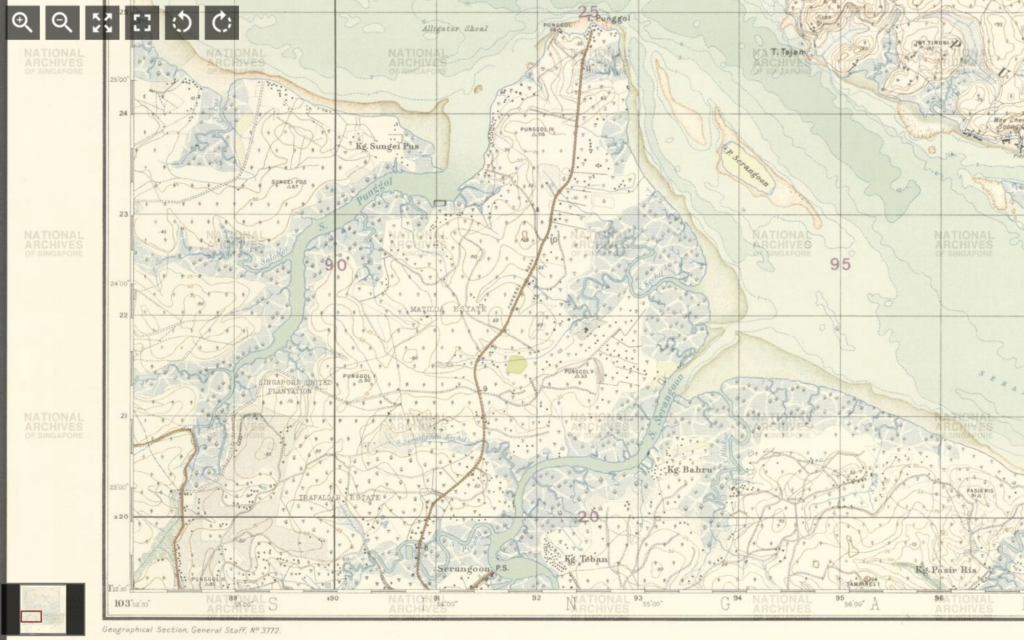
In Singaporean heritage projects, the spatialisation of Punggol has been the particularity of its “Track” system.3 However, when we examine maps from the National Archives of Singapore, the “Track” system first appears only on maps after 1959 – the year Singapore attained full internal self-government.4 Before that, topographical maps of Punggol were produced by the colonial-era Singapore Survey Department. These surveys were fixated on features such as railway widening lines and municipal boundaries. These maps also used the ‘mukim’ system; and between the first maps in the nineteenth century and 1959, little new information was added for each new addition for the focus was on land titles and land use.5

Correspondingly, this gulf is echoed in oral history interviews. On the other hand, oral history interviewees who were born before the 1950s used the Punggol ‘milestone’ markers as their way of spatialising Punggol.6 What remains similar in pre-1959 and post-1959 accounts, beyond the use of property and the association of land with ownership, is the exacting of demographic association down to specific streets for different dialect groups and surnames – a phenomenon Yeoh has elaborated on clearly in Contesting Space.

Yet, another primary source in 1957 presents a completely new dimension to Punggol history. In 1957, Muhammad Ariff Ahmad, a teacher based in Sekolah Melayu Ponggol (Ponggol Malay School), published Tok Sumang, the tale of his great-grandfather. In the English translation7 we learn that Tok Sumang had originated from Pahang and that his family had never been ‘fixed at one place’ – it was in the aftermath of war training on Tekong that he decided to move to ‘neighbouring Singapore, which was covered with dense forests and home to crocodiles and snakes.’ By 1891, Tok Sumang (‘always accompanied by his shovel and violin’) and his followers had agreed with the British that the land would never be taxed in exchange for the British construction of a road – the road that was built leading to the shore of Tanjong Punggol was named “Jalan Wak Sumang”. This was a different location of Punggol, not as an administrative unit in Singapore, and far from the contemporary understanding of the sovereign Singaporean nation-state as the center.

My comparison of Survey Department maps and different recollections of Punggol over time merely scratches the surface. In this case, the Surveyors’ maps did not merely lack markers of local knowledge. Between the Survey Department and internal self-government, topographical indicators said more of each administration’s goals than of Punggol’s historical particularity. The former emphasised land value, while the latter identified features of ‘community’ according to its own understanding, including landmarks such as ‘community centres’ and ‘police stations’. Secondly, the proliferation of a range of historical memories demonstrates one way in which the Lefebvrian idea of the “lived” can be actualised. Methodologically, I argue that there are far-reaching implications in using oral history to challenge the urban planner’s primacy. Oral histories and heritage culture, however state-directed either might potentially be, still spatialise a multiplicity of histories in ways that an urban planner’s map cannot.

  1. Chuck Wooldridge, City of Virtues: Nanjing in an Age of Utopian Visions, Seattle: University of Washington Press, 2015, pp. 117-149. []
  2. Brenda Yeoh, Contesting Space in Colonial Singapore: Power Relations and the Urban Built Environment, Singapore: NUS Press, 2003, pp. 28–78. []
  3. https://remembersingapore.org/2018/09/30/old-punggol-road-26-tracks/ []
  4. Singapore Survey Department, Singapore 1961 – Tampines Accession Number TM000054_3. The use of “Track” is further replicated not just on topographical but electoral maps following this, with the post-1959 maps also taking care to mention vital community fixtures such as community centres and police centres – itself a change that deserves a discussion beyond the scope of this post. []
  5. The Singapore Land Authority uses the system today, explaining that “Every land parcel in Singapore is uniquely identified by a lot number. This identifier has two components, namely the survey districts Mukim (MK) or Town Subdivision (TS) number and the lot number.” Mukim is a Malay word meaning ‘district’ with its roots from the Arabic مقيم (resident). []
  6. Lee Chor Eck, Oral History Interview with Chai Yong Hwa Accession Number 000172. https://www.nas.gov.sg/archivesonline/oral_history_interviews/record-details/e0d5e6eb-115d-11e3-83d5-0050568939ad?keywords=Punggol&keywords-type=all. See especially reel 3 and reel 7. Maria Boon Kheng Ng, Oral History Interview with Hong Siew Ling, National Archives of Singapore . https://www.nas.gov.sg/archivesonline/oral_history_interviews/record-details/f09a160a-115d-11e3-83d5-0050568939ad?keywords=Punggol&keywords-type=all. See reel 3. []
  7. Muhammad Ariff Ahmad (trans. Ahmad Ubaidillah), Tok Sumang, (Singapore: Geliga Limited, 1957). https://biblioasia.nlb.gov.sg/vol-19/issue-2/jul-sep-2023/tok-sumang-english/ []

The Koningsplein: Urban Planning and Beautification in 1930s Jakarta

The 1930s saw a push by the Dutch colonial government of Indonesia to “modernise” the the country’s urban spaces. In 1934 a Town Planning Commission was established with the aim of developing urban planning regulations and guiding redevelopment. It presented its findings in 1938, advocating for the replacement of ad hoc urban development with a more centralised, methodological approach. They felt this would produce “harmonious” towns which would surely become reflected in the character of its inhabitants.1

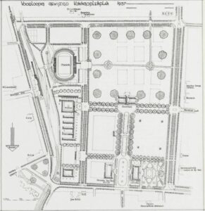
Source: IBT Locale Techniek (1937:  p. 161)2

This 1937 plan for renovation to the Koningsplein, modern day Merdeka Square in central Jakarta, can be seen as symptomatic of the new philosophies of city planning sweeping Dutch Indonesia during this period. The plans centre on the town hall, placed amongst open green squares, at the junction of two boulevards. A stadium is situated in the south-east quadrant of the square and other notable buildings are visible along the edges, such as the Java Hotel and the Governor General’s palace.

One aspect of this plan which is immediately obvious is the desired beautification of the Koningsplein. The tree-lined avenues and inclusion of an intricate gardens in the north-western section of the square attest to the fact that this space was intended to inspire appreciation for the natural. Thomas Karsten, a prominent urban planner at the time, advocated for the inclusion of nature within the city, as long as it was carefully zoned and remained within its bounds.3

Colombijn and Cote argue that the reason for this attention to natural beauty is that urban beauty was intrinsically linked with the quest for order and control in colonial spaces.4 Order and organisation were seen as beautiful and beauty was believed to engender civility among citizens. The embodiment of this philosophy in the Koningsplein plan can be seen in the manicured lawns and geometrically divided sectors of the square. Ordered natural beauty within the square was intended to inspire an ordered society around it.

This approach to city planning echoes the City Beautiful movement, a philosophy which came to prominence in North America in the late 19th and early 20th centuries. Although the application of the City Beautiful movement necessarily differed by context, Peter Hall argues that its core tenant was the use of architecture and planning as theatre. As part of this movement, investment in urban beautification became a way to signal different values to a cities inhabitants and influence them in a positive fashion.5

The influence of the City Beautiful movement can be seen here, not only with the structured nature of the square, but also in the intended grandeur of the Town Hall and the Stadium. By placing these buildings in the middle of the square, surrounded by open space, they become the focal points of the space. Thus, the plan attempts to inspire respect and admiration for these symbols of Dutch government and modernity and, by extension, legitimise the colonial government.

Due to the Japanese invasion of Indonesia and the advent of World War II, these plans, along with many others, were never enacted . After the conclusion of the war and the Indonesian Independence movement, the Koningsplein was renamed Merdan Merdeka, or “Independence Square”. It was then redesigned and now consists of four diagonal streets radiating out from a new central National Monument.

The history of Merdeka Square and the Koningsplein is an interesting study in the shifting values of urban spaces. Once a key symbol of colonial aspirations for “modernisation” and order, it has since transformed into one of the country’s most visible monuments to independence. However, it has remained a tool of the government throughout, a way for regimes to articulate their priorities and values to the masses.  As such, though the specific values it transmits may have shifted, it can be seen to still embody the early 20th century philosophies of urban planning as theatre.

  1. Pauline van Roosmalen, ‘Netherlands Indies Town Planning: An Agent of Modernization (1905-1957)’ in Cars, Conduits, and Kampongs, eds. Freek Colombijn and Joost Cote (Boston, 2015), p. 98. []
  2. view (colonialarchitecture.eu) []
  3. Freek Colombijn and Joost Cote, ‘Modernization of the Indonesian City, 1920-1960’ in Cars, Conduits, and Kampongs, eds. Freek Colombijn and Joost Cote (Boston, 2015), p. 3. []
  4. Ibid. []
  5. Peter Hall, Cities of Tomorrow: An Intellectual History of Urban Planning and Design since 1880 (2014), p. 236. []

Keeping Cool: Investigating Air-Conditioning in South East Asia

The searing heat and high humidity of most of South East Asia (SEA) make it at the best of times, a challenging environment to live and work in. From my personal experience in these perpetual summers, the amount that one sweats simply just from walking is impressive. With salt lines forming down shirts and sweat dripping down arms, the most ubiquitous form of reprieve comes in the form of air-conditioning (AC). When did AC become the norm for many public places in SEA? From trains to shopping malls, restaurants to private homes, they provide comfort for millions every day. The technology and story surrounding AC tell a fascinating story of how people reconceptualised their relationship with the natural environment and how economic factors and the accessibility of technology made cooling through AC commonplace in SEA.

The history behind air-conditioning in South East Asia is the most well documented in Singapore, or at the time the Federation of Malaya. Newspaper clippings from the late 1930s provide a wealth of insight into the trends surrounding air conditioning at the time. The Sunday Tribune, a newspaper that ran between 1931-1951 ran numerous articles extolling the virtues of cool and humidity-free air. [1] Most of the articles pointed to the benefits of comfort in homes and public spaces and even benefits to industry. Despite the generous suggestions that all spaces would soon be air-conditioned, first-hand accounts gleaned from older Singaporeans born before the 1970s suggest that despite the invention of AC technology many decades earlier; It took a great deal of time before they were implemented in the private home. [2] The main reason quoted for this was due to the cost of electricity and the general acclimatisation that many older Singaporeans had to the heat. Fans, open windows and ventilation holes in walls were much more common in private homes during this period.

So, when did air conditioning transition from the public to the home? While the evidence is quite lacking in Singaporean and SEA accounts, a detailed economic study of home AC units based on energy consumption trends in the United States points out a few interesting trends. Jeff Biddle examines the uptake of ‘residential AC’ in the US from the mid-1950s to 1980s and remarks that a change in income, climate, and average electricity rates led to the uptake of AC in homes. [3] One of his key findings was that by the late 1980s the vast majority of Americans had ‘residential AC’. Although the form of economic history he conducts focuses more on macro-economic trends rather than the individual experiences of homeowners, it nonetheless provides a starting point from which we can discuss the uptake of AC in other parts of the globe. One of the key technological improvements Biddle discusses is the competing types of AC, namely central and unit inverters. Where the first required a lot more foresight in terms of installation, the second functioned similarly to any other household appliance and was essentially ‘plug and go’. Essentially the convenience of these inverter units was crucial to the uptake of in-home AC units. The uptake of AC in the home changed the way that people lived quite significantly. Despite its lack of prevalence the possibility in quality of life changes were discussed in newspapers as early as the late 1930s. [4] Taking a public health standpoint, these primary sources cogently pick apart the issues of drastic shifts between indoor and outdoor spaces with the advent of AC.

In the February 10th issue of the Sunday Tribune, the author expresses the concerns of a certain Prof. K. Black, that proposes that the sudden transition from a “refrigerated room” into the tropical heat and vice versa would cause health issues. [5] The author rebukes this claim by arguing that AC merely changes the indoor atmosphere by a few crucial degrees. A claim that is not quite true in the modern-day. Marlyne Sahakian conducted some fascinating research using phenomenological techniques (interviews) to better understand modern societal perspectives and practices regarding AC in the Philippines. In a short section detailing the author’s personal experience as a pregnant woman, she expressed that moving from an intensely air-conditioned room into a warmer space put a strain on her personally. In a few succinct words, “it’s freezing!” she describes the feeling whenever she was in her parent’s or friends’ houses. [6] Sahakian cleverly intersperses these phenomenological accounts (whether personal or other) with solid evidence on historical cooling techniques and the slow evolution of cooling technology in different climates and geographic locations. This sort of social and technological history is precisely what is required in the study of artificial cooling as a phenomenon. Her cogent comments on global standards of ‘comfort’ link well to the existing debates on perceptions of heat and acclimatisation in tropical environments, a topic that is the central debate of Jiat-Hwee Chiang in her book on tropical architecture.

In Jiat-Hwee Chang’s, A Genealogy of Tropical Architecture, she comments on the power dynamics that presupposes many architectural decisions made in SEA. Although her work is at times difficult to understand, she illustrates the key problem of a priori tropicality logic that runs through architectural concepts in tropical environments. [7] Her arguments about these presumptions are quite accurate, but arguably fail to capture the actual human practices that surround cooling. Despite this, Sahakian’s idea that there is a lack of consensus on global standards of comfort synchronises well with Chang’s concepts that ‘tropical architecture’ should not be dominated by western ideas. After all, acclimatisation and adaptation mean that people suited to living in tropical climates perceive heat differently, and buildings and dwellings, should in theory reflect this. [8]

The seemingly hodgepodge of sources presented are but a preliminary survey of accounts that have been gathered in the process of research for a much larger piece of work. The crux of this entire project on cooling rests both on the perceptions of comfort concerning cooling, and how society changed during the period where fans were replaced by AC units. This should raise some interesting questions on changing perceptions of comfort, and the influence that it has had on society. Quite curiously, it also delves into concepts of tropicality, and whether AC supports or subverts its key tenets. Ultimately, a research topic that appears to be worthy of closer examination.

Sources

[1] National Library of Singapore, Reel N1452, Sunday Tribune, entry 10 February 1935, page 10.

[2] Chiang, interviewed by Roger Loh, 8th March 2022, interview 1.

[3] Jeff Biddle, ‘Explaining the Spread of Residential Air Conditioning, 1955-1980’, Explorations in Economic History, 45:4, (September 2008), p. 2.

[4] National Library of Singapore, Reel N1452, Sunday Tribune, entry 10 February 1935, page 10.

[5] Ibid.

[6] Marlyne Sahakian, Keeping Cool in South East Asia: Energy Consumption and Urban Air-Conditioning, (London, 2014), p. 66.

[7] Jiat-Hwee Chang A Genealogy of Tropical Architecture: Colonial Network, Nature and Technoscience, (London, 2016)

[8] Ibid.

Hell on Earth: Spatial Representations of Pain as a Moral Deterrent

My investigation into the 10 Courts of Hell as part of my long essay has led me down some interesting paths looking at various depictions of hell in parks and temples within the East Asian and South-East Asian context. In the European context, hell and various forms of the underworld are most often depicted in the form of art, essentially a 2D rendering, and lacks a physical and spatial representation. Although Buddhist and Daoist conceptions of hell do exist in a similar artistic form, it appears that many have made the jump from canvas to statue, and from statue to entire walk-in spaces. Both Haw Par Villa’s ‘Ten Courts of Hell’ (which is quite ironically being renovated to be air-conditioned) and Thailand’s Wat Mae Kaet Noi, both have explicit spatial depictions of hell, in park form that are ripe for analysis.

When I visited Haw Par Villa this summer, it was a shame that the Hell portion was closed for renovations. However, this particular part of the park is what exists in the living memory of many Singaporeans as being the most unsettling part of it. The purpose of this Chinese (in a mostly Daoist way) depiction of Hell had a clear moral purpose. Firstly, depictions of hell generally are seen as warnings and deterrents. As a writer from the New Yorker quite eloquently put it “The afterlife is an old room in the house of the human imagination”. Both Haw Par Villa and Wat Mae Kaet Noi’s spatial depiction of Hell fills this room with images of unimaginable pain and torture to those who commit sins or acts that are deemed immoral by society. This form of guiding morality through spatial representation has been used more positively, for instance in certain parts of Beijing’s parks in the Republican period. Where Republican ideals are enshrined in statues and poems on walls. However, perhaps the creators of this park understood that often fear is a more powerful motivator than the promise of reward.

This form of moral education through deterrent was applied to specific immoral acts that had corresponding punishments. In the case of Wat Mae Kaet Noi, that depicts a Buddhist conception of hell, Naraka. We see graphic representations of adulterers and promiscuous individuals experiencing the most severe forms of genital mutilation, scenes of badly-behaved schoolchildren having their tongues pulled out of their bodies and the sort of gore that would be perfectly at home in a horror film.

Haw Par Villa’s approach to depicting the punishments for specific crimes are done in a much more structured way. Each of the Ten Courts of Hell is meant to judge different sins and the strong Legalist undercurrent that pervades through Chinese culture is evident here. In each court presides a Yama (यम)a Hindu and Buddhist deity of the underworld. In both instances, they act as lawgivers, enforcers of the Dharma and punishers of wrongdoing. This concept must have appealed to existing Confucian concepts of fair judgement and punishment even in the afterlife and incorporated into Chinese conceptions of Hell.

After an initial trial in the First Court, which determines whether the virtuous acts in your life outweigh the evil. A person will either be sent across a “bridge” to reach paradise or to a corresponding Court of Hell that will mete out their punishment. The different crimes that each Court is responsible for are seemingly quite disparately organized, with rapists and rumour mongers being sent to the same Seventh Court. At the Tenth Court, offenders are handed a magical cup of tea and reincarnated. Similarly, to Wat Mae Kaet Noi, there are also grisly depictions of amputation, decapitation and being boiled alive. Neither parks are for the faint of heart and are intended to be as gruesome as possible.

One key aspect of both representations of Hell is that they are both cyclical. Whereas Christian conceptions of Hell are that of a terminus, Buddhist Hell may be considered more as purgatory if seen from a Western perspective. The existence of the Wheel of Reincarnation (related to the Buddhist concept of Nirvana) simply sees hell as a transitionary place where individuals go to receive punishment for their crimes before moving on to either paradise, whether in a 極楽 (Gokuraku) Pure Land Sense, or a Nirvana sense. In each instance, there is always hope for redemption. This strong soteriological message suggests that the fundamental conceptions of life and death, crime and punishment, in societies influenced by Buddhism was different.

Both depictions of Hell encourage virtuousness and morality in the current life that one is living in by graphically depicting what will happen if they don’t. More importantly, the existence of these depictions in the form of dioramas and parks were to convey this message to those that couldn’t read. Despite the original intention of these depictions being for the illiterate, they still serve as a powerful reminder to those that can. Showing, rather than telling us what may happen if we don’t lead a virtuous life.

Note: As the images are too graphic to be displayed on this blog, below are the links to both parks:

Ten Courts of Hell: Haw Par Villa, https://www.wheresidewalksend.com/court-of-hell/
Wat Mae Kaet Noi: https://matadornetwork.com/read/scariest-temple-thailand/

A Spatial Construction of Dual Identities: South Asian Convicts Labourers in the Strait Settlements

For the long essay, I aim to discuss the use of South Asian convict workers in the construction and maintenance of Strait Settlement colonies by the British in the late 18th and early 19th centuries. I will provide a particular focus on Penang and Singapore, presenting how these colonies were both spaces of imprisonment and spaces of individual freedoms.

On a theoretical level, I have drawn influence from Lefebvre’s conception of space as socially constructed, constituted of multiple layers, each with its unique set of meanings.[1] Strait Settlements were spaces of life imprisonment where the agency of individual labour was requisitioned and used for colonial expansion and maintenance. However, Strait Settlements were spaces where convicts could construct heterotopic identities, one of perpetual imprisonment and one of individual agency and value.

Additionally, I have drawn heavily upon Anand Yang’s recent publication, Empire of Convicts and his argument of a duality of identity experienced by convict workers. He highlights how the necessity for labour in distant colonies created an environment for which convicts could express a degree of agency in their own lives, calling themselves Company ke Naukar (workers of the company) rather than Bandwars (prisoners).[2] I plan to present the spatial construction of Strait Settlements as conduits for convicts to express this duality of identity.

In terms of primary sources, the National Archives of Singapore provides an excellent base to acquire Strait Settlement government reports (A08-A24 Penang Consultations), maps (Singapore Survey Department), and newspaper articles (Straits Times, Malaya Tribune, Singapore Free Press) on the use of convict workers in Strait Settlement colonies.[3] Blue Books and Consultation notes provide statistical data and activities on the movement, use and disposal of south Asian convict workers.[4] These sources provide knowledge on the scale of convict worker usage and the nature of how they were used in settlement construction and maintenance. Letters and correspondence from governors such as Francis Light, George Leith, Robert Farquhar and Stamford Raffles highlight direct correspondence with the East India company on discussions related to the usage of convict workers. Finally, I aim to look at Calcutta criminal and judicial records to provide information on individual convicts who arrived in the colonies.

However, one of the main limitations of the project are the limited voices of the actual convict workers who laboured in the colonies. Most of the literature focuses on the perspective of the colonial government, which makes it challenging to ascertain viewpoints of convict imprisonment from the perspective of the convict. To alleviate this issue, I plan to look at how spatial conditions and policies were created for the convicts to express the duality of identity. An example of which being the construction of Convict Lines, residences for the labourers. The space was created to hold convicts and was designed to prevent escape, displaying a space of imprisonment.[5] However, the Lines were constructed in the centre of the city, separate from the local jail and correctional centre, which was placed away from the city centre – displaying a distinct sense of identity from being just a convict.[6] Their spatial location and distinct separateness present the creation of identity above the status of a convict.


Bibliography:

Primary Sources:

Internet Archive, Blue Book for the year 1873, 1873 <https://archive.org/details/dli.granth.73418> [accessed 28th October 2021].

McNair, John, F.A., Prisoners: Their own Wardens (Westminster, 1899).

National Archives of Singapore, A25: Penang Consultations, 1826, <https://www.nas.gov.sg/archivesonline/> [accessed 28th October 2021].

National Archives of Singapore, Survey Department, Singapore <https://www.nas.gov.sg/archivesonline/maps_building_plans/source-details/651> [accessed 28th October 2021].

Newspaper SG <https://eresources.nlb.gov.sg/newspapers/> [accessed 28th October 2021].

Secondary Sources:

Lefebvre, Henri, The Production of Space (Oxford, 1974).

Yang, Anand, Empire of Convicts (Oakland, 2021).


[1] Henri Lefebvre, The Production of Space (Oxford, 1974), pp. 11-14.

[2] Anand Yang, Empire of Convicts (Oakland, 2021), pp. 95-143.

[3] National Archives of Singapore, A25: Penang Consultations, 1826, <https://www.nas.gov.sg/archivesonline/> [accessed 28th October 2021];

National Archives of Singapore, Survey Department, Singapore <https://www.nas.gov.sg/archivesonline/maps_building_plans/source-details/651> [accessed 28th October 2021];

Newspaper SG <https://eresources.nlb.gov.sg/newspapers/> [accessed 28th October 2021].

[4] Internet Archive, Blue Book for the year 1873, 1873 <https://archive.org/details/dli.granth.73418> [accessed 28th October 2021].

[5] John, F.A. McNair, Prisoners: Their own Wardens (Westminster, 1899), p. 16.

[6] Ibid., p. 23.

Badly Drawn Maps

Badly Drawn Maps and what they can teach us

What makes a good historical map? Do detail and accuracy outweigh aesthetics and simplicity? Alternatively, what makes a bad historical map? Plenty of contemporary pop culture articles find entertainment in examining strange historical maps, assuming their scientific inaccuracy is something comical. But within these ‘inaccuracies,’ can we find historical insight we might have otherwise overlooked? This is the essential question Martin Bruckner seeks to answer. Don’t dismiss a historical map based on assumptions of what makes a ‘good’ or ‘bad’ map, argues Bruckner, rather we should explore why these definitions exist in the first place.

When examining maps, we make various assumptions about the relations of the map: the territory itself as existing independently of the map, north/south being top to bottom, east/west being right to left, and so on.[1] The “old” method of understanding historical maps, according to Bruckner, suggests that ‘good’ maps have unmistakable meanings, and ideals like truth and error are conceptually presented through them. They are the products of empirical science.[2] The map is a representation of a place. Yet, from the 1990s, ‘place’ began to be thought about more broadly, and scholars began treating maps as “subjective representations of social locations and human activities.”[3] This understanding also treats maps as places themselves.

In this view, maps are considered text-specific locales, or sites, shaped by a variety of contexts, ranging from the biography of the mapmaker to the geography of map production to the language of maps.”[4]

For Bruckner, however, our analytic approach to maps should go a step further than this text-based understanding. Historical maps are representations of places deeply endowed with sociality, being both man-made and “man-used.”[5] He argues for considering maps as products of social practice, shaped by all of the aspects that go into their creation; they are moulded by the engraver, painter, ink and paper suppliers just as much as the scholars and librarians who consume them.[6] Similarly, Matt Reeck views maps as “architecture of mind”. He argues they are a dynamic component of a historical process of commerce and settlement: “The advent of good maps is the advent of control over the land…”[7] For Reeck, mobility and movement of peoples is directly connected to cartography, and yet maps too often seek to standardize this; they aspire to “place places outside of time.”[8] Maps are social constructions, they push political agendas and represent societal attitudes. Their creation is often greatly influenced by power interests completely outside of the cartographic industry. Thus, can historical maps truly be deemed either ‘good’ or ‘bad’?


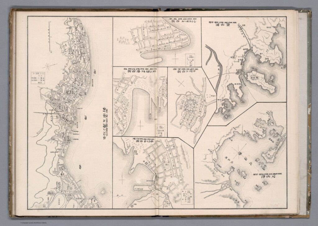
Taking Bruckner’s social approach, empirically ‘bad’ historical maps can now be considered useful and insightful in how they relate to issues other than physical geography. We can provide maps, seemingly objective creations, with historicity and time. Although developed in an American context, Bruckner’s approach can be equally applied to historical maps from East Asia. Examine this 1906 (Meiji 39) map by Japanese cartographer Yamane Akisato:


This atlas page shows 7 maps of various East Asian cities. Included (from left to right) are Hong Kong, Singapore, Vladivostok, Saigon, Bombay, Busan, and Wonsan. The maps show details of the city plan (roads, rivers, railways, etc.), the coastal outline, and major buildings, such as military stations. They are drawn in a simplistic black and white line drawing, which allows for a focus on the layout and structure of the cities and makes them easy to compare. These city maps were published in the atlas in between more detailed and coloured maps and illustrations, and the atlas includes text in both Japanese and Chinese. You may notice that these simple drawings are particularly ‘inaccurate’, or, in the very least, lacking detail. The coastline in the top-centre city (which I assume is meant to be Singapore, although it is difficult to tell) is comically simple, as if included in the compilation as an afterthought. In comparison, the coastlines of Busan and Wonsan on the right are drawn with more extreme detail. Deer Island in Busan’s Bay is especially noticeable, and details of smaller islands and water depth is even included. Although the map of Hong Kong (located far left) is denser, several of the streets are mislabelled in comparison to the reality of their positionality to one another. This strange picking-and-choosing of what details to include and what details to leave out by Akisato, the cartographer, is what makes this map so fascinating. If we now apply Bruckner’s social approach to analysing this map, it opens up the potential for historical interpretation and insight to be gained from it.


Drawn from the Japanese perspective in 1906 (Meiji 39), the map tells us how Japanese citizens might have seen and understood the world, and the importance of other cities in East Asia in comparison to their own. Placing these maps within the historical context of Japan’s activities in 1906, it makes sense for the map of Busan to detail so clearly the coastline and water depth around the city. Busan was a treaty-port which the Japanese held particular influence over around the time this map was published, and in which a strong Japanese presence had existed since the 15th century. Busan was the foothold through which Japanese forces established their control over the Korean peninsula prior to annexation in 1910.[9] It is likely Akisato may have visited Busan directly during his life, although not much is known about the cartographer himself and this is merely hypothetical. Regardless, as a Japanese citizen Akisato would have had, at the very least, more readily available access to information about Busan than to information about Singapore, for example, which was under British colonial control at the time.

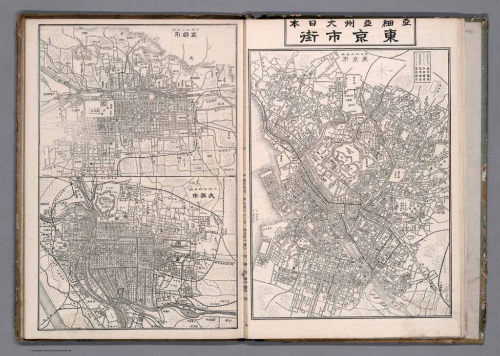
More acutely, these maps tell us how Akisato thought these cities should be presented in his atlas, and thus to those learning from his atlas. This highlights what he might have thought relevant, or in this case, not relevant, to be teaching other Japanese consumers about the wider world and about other cities across Asia, especially in comparison to Japan’s own major cities. There is a similar insert page in the same atlas that depicts Tokyo and its surrounding areas, Kyoto, and Osaka. These maps, meant to act as educational tools in the same way as the first 7 we examined above, are extremely dense, showing the grid block layouts of these cities in exact detail.


Considering the Japanese colonial context under which these maps were created once again, we can invoke Bruckner’s social approach to understand why these Japanese cities are presented more carefully. In the book How to Lie with Maps, Mark Monmonier argues that nations often enhance map features that support their point of view on the world and leave out details on the features that sit contrary to this.[10] Is this what is occurring here with Akisato’s atlas? Potentially, but further insight into this would require more research on his career and the publishing details of the atlas itself. At any rate, these maps are shaped deeply by Japanese colonialism and the power relations at play in East Asia in the early 1900s.

J. B. Harley maintains that historians of cartography often simply accept the cartographer’s suggestions of what historical maps are meant to represent, and advocates for greater scrutinization of maps as forms of knowledge creation. [11] The relationship between representation and reality contained within maps affects our relations to and perceptions of the material world, which is all the more pertinent considering a historical context far prior to the information technology era. These historical Japanese maps of various East Asian cities provide a good example of how we can scrutinize as Harley suggests, and they offer a great entry point for further research in this area.


[1] Searle, John. R., ‘Chapter 4: The Map and the Territory,’ in Wuppuluri, S. & Doria, F. A. (eds.) The Map and the Territory, Springer International Publishing (2018): p. 72

[2] Bruckner, Martin, ‘Good Maps, Bad Maps; or, How to Interpret A Map of Pennsylvania,’ Pennsylvania Legacies, Vol. 9, No. 2 (November 2009): p. 40

[3] Ibid, p. 40

[4] Ibid, p. 40

[5] Ibid, p. 40

[6] Ibid, p. 41

[7] Reeck, Matt, ‘A Brief History of the Colonial Map in India – or, the Map as Architecture of Mind,’ Conjunctions, No. 68, Inside Out: Architectures of Experience (2017): p. 185

[8] Ibid, p. 185

[9] Kang, Sungwoo, ‘Colonising the Port City Pusan in Korea: A Study of the Process of Japanese Domination in the Urban Space of Pusan During the Open-Port Period (1876-1910)’, Ph.D. Dissertation, University of Oxford (2012): p. 86

[10] Monmonier, Mark S., How to Lie with Maps, 3rd ed., Chicago: University of Chicago Press (2018): p. 132

[11] Harley, J. B., ‘Deconstructing the map,’ Passages, University of Michigan Library https://quod.lib.umich.edu/p/passages/4761530.0003.008/–deconstructing-the-map?rgn=main;view=fulltext [Accessed 09/10/21]


Primary Sources:

Akisato, Yamane, “Buson, Wonson, Vladivostok, Saigon, Bombay, Hong Kong.” from New Atlas & Geography Table (Bankoku chin chizu chiri tokeihyo), Nakamura: Shobido, Meiji 39 (1906) https://www.davidrumsey.com/luna/servlet/detail/RUMSEY~8~1~313791~90082699:Buson–Wonson–Vladivostok–Saigon-?sort=Pub_List_No_InitialSort&qvq=q:vladivostok;sort:Pub_List_No_InitialSort;lc:RUMSEY~8~1&mi=11&trs=12# [Accessed 08/10/21]

Akisato, Yamane, “Tokyo and environs, Kyoto, Osaka.” from New Atlas & Geography Table (Bankoku chin chizu chiri tokeihyo), Nakamura: Shobido, Meiji 39 (1906) https://www.davidrumsey.com/luna/servlet/detail/RUMSEY~8~1~313790~90082700:Tokyo-and-environs–Kyoto–Osaka?sort=Pub_List_No_InitialSort&qvq=q:author%3D%22Akisato%2C%20Yamane%22;sort:Pub_List_No_InitialSort;lc:RUMSEY~8~1&mi=21&trs=36 [Accessed 10/10/21]

Between the Municipal and Inhabitant: The Push and Pull of Power

The battle for power expression and control between the municipality and their inhabitants is a recurring theme in many of the stories that discuss cities and their development. These groups are by no means monolithic and many have substantial splits in their interests, however, as analytic units, it is fair to categorise them as such. From Shanghai to Singapore, Beijing to Changchun, there were also, subtle interplays of power and class that hint towards wider power structures. It is this combination of push and pulls between the municipality and its inhabitants, and the way that power was negotiated that is the main subject of this post.

In the case of Shanghai, an often hilarious but deeply saddening state of affairs was the segregation of Chinese and European populations. The imagined signposts saying “No dogs or Chinese”, although more a myth than reality, is a reminder that many European municipal councils had clear ideas over specific racial usages of space. [1] In the Shanghalander case especially, desires to enforce extraterritoriality and full sovereign control would have meant within these “European spaces” whether represented or real, were backed by real expressions of power.

For Singapore, the representations and usage of space laid out by the plan strongly indicated that colonial and later municipal authorities struggled to identify and assert control over the various Malay “Kampungs” (living areas). This was mostly because many lived outside of the main areas that were of interest to Raffles and Farquhar and that language provided a formidable barrier to understanding these places. [2] The Chinese areas were also dominated by various bāngqún (幫群) organisations that represented the inhabitant population. These “bāng” held considerable power that sometimes ran against colonial designs for the city. [3]

For both of these cities, there were clear examples where attempts to assert municipal or colonial control were either subverted or resisted. Although there has not been much mention of Malay or Indian resistance towards certain municipal policies. The Chinese community in Singapore, being larger in size and power, did actively mobilise their influence. In response to the unilateral passing of Police Acts in 1857, the entire Chinese community went on strike, effectively halting the economy for a few days. Despite this strike not being an act of open and violent revolt. It nonetheless serves as an example where local inhabitants expressed power through shockingly effective strategies. For Shanghai, unarmed demonstrations against what was presumably the exclusion of Chinese from public parks and spaces amongst other measures is a good example of inhabitant resistance towards assertions of municipal power. Furthermore, Chinese requests for better municipal representation could also be counted as legitimate bids to integrate inhabitant interests into municipal decision making.

That being said, the case of Shanghai is unique, as what qualified someone as an “inhabitant” was quite nebulous. Did the community of White Shanghailanders count as inhabitants? Or was this definition limited to the Chinese. The somewhat cop-out answer of “both”, makes the most sense. While local Chinese were most definitely counted as the original inhabitants of the city, many Europeans eventually were considered ‘local’ inhabitants of the area. The main difference was that often Europeans were allowed to actively participate in the decision-making processes that ran through the SMC, while the Chinese struggled to acquire that privilege. [4] Singapore’s definition for “inhabitant” was often a lot clearer, the existing Chinese, Malay, Indian and Orang Laut settlements created a distinct divide between European colonisers and local communities.

This leads us to the interesting intersection of class and race in both Singapore and Shanghai. In both cases, English educated and typically Chinese businessmen were sometimes permitted to join the ranks of municipal decision-makers. This was more so the case in Singapore where businessmen of considerable stature such as Seah Liang Seah, founder of the Ngee Ann Kongsi and Choa Giang Thye, also a prominent member of the Chinese Chamber of Commerce, actively participated in municipal politics and advocated for the Chinese Community as early as 1857. [5] The English language ability of these higher-class Chinese businessmen afforded them access to the primarily European sphere of politics. They often acted as interlocutors for local populations, albeit only to a degree. Their lack of sustained and direct involvement in Clan and Bāng organisations may have impacted their ability to fully represent their constituent compatriots. In Shanghai, SMC postings were barred to the Chinese until 1920, the ‘virulent racism’ of Shanghailanders often prevented even prominent Chinese businessmen from entering the municipal sphere.

In conclusion, throughout any spatial story, there was often a battle for power expression and control between the municipality and their inhabitants. This was sometimes mediated by prominent members of the inhabitant community (often Chinese) that could communicate in English and thus partially enter into municipal decision-making. The reality is that the interests of municipal bodies and the actual inhabitants did not always coincide, whether due to racism or language (mostly racism). Although the impacts of this are not necessarily felt today, we can certainly see the struggles of the voiceless coolie, or hawker store vendor, that rarely had a voice in how their city was run.

[1] Robert Bickers ‘Shanghailanders: The Formation and Identity of the British Settler Community in Shanghai 1843-1937’ Past and Present (May, 1998), p. 205 

[2] The Jackson Plan (Singapore, National Library of Singapore, 1822

[3] Brenda Yeoh Contesting Space in Colonial Singapore (Singapore, 2003) p. 39

[4]Robert Bickers ‘Shanghailanders: The Formation and Identity of the British Settler Community in Shanghai 1843-1937’ Past and Present (May, 1998), p. 205

[5] Brenda Yeoh Contesting Space in Colonial Singapore (Singapore, 2003) p. 61