The Entertainment Function of Museums seen in Singapore’s Botanic Gardens

In 1949, Sir John Forsdyke, Director of the British Museum, lectured to the Royal Society of Arts on how ‘the most important educational service, common to all museums is the entertainment and instruction of children’’.1 He explained how museums could feature two forms of popular entertainment; ‘music and the cinema’.2 Forsdyke’s lecture reflected Gareth Knapman’s observation that during the 19th century, museums were ‘as much about entertainment as research’3 , and the audience that museums attracted ‘was looking for entertainment’.4 I found this shift towards museums becoming spaces for popular entertainment instead of practices for solely academically important topics interesting, as this shift also occurs within Singapore’s Botanic Garden. This blog post focuses on how the development of the museum into a space of entertainment also occurs in Singapore’s Botanic Gardens. This is an important focus as it is a useful contribution towards my broader long essay idea that the Singapore Botanic Gardens was Singapore’s first museum. The Singapore Botanic Gardens strayed from its defined purpose of a space for ‘the scientific study of plants’ as it increasingly accommodated entertainment practices.5 The specific entertainment practices in the Singapore Botanic Garden that this blog post will examine are the Gardens’ weekly band performances.

The significance of band performances within the Singapore Botanic Gardens is immediately apparent through their mention in the first by-law published in the Official Guide to the Gardens, printed by the Singapore government in 1889.6

‘The Botanical Gardens shall be open to the public daily from sunrise to sunset, and, on nights when the Band plays, to 11 p.m.’7

This specific mention highlights the importance of entertainment to the Gardens because the by-laws represented the official rules of governance and conduct indicating that entertainment was a formally approved function of the Gardens. Furthermore, extending the opening hours from their regular timings illustrates the Garden purposely catering to the performances and their audiences, suggesting entertainment practices were not only approved but encouraged. The official guide served as the principal medium by which the government communicated to visitors how they wanted the gardens to be viewed and used. Thus, this reference to band performances within the first page publicised not only to officials but also to ordinary visitors that the bands, and other entertainment events, were an integral, standard, and unquestioned service of the Gardens despite their lack of relation to the Gardens’ traditional focus on scientific research. The performances were also a focus of the Garden’s Annual Reports, which featured a section for ‘concerts’.8 This section recorded the number of performances that year and other shows, such as ‘variety shows’ staged in the Gardens.9 This official practice of recording the entertainment practices further emphasises how the entertainment function of the Gardens was considered important because it was monitored in the same way and within the same medium as the Gardens’ scientific practices. This illustrates how similar to museums, the Singapore Botanic Gardens developed into a space that was ‘as much about entertainment as research’.

Alongside the band performances featuring in the Gardens’ official publications, multiple Singapore newspapers published articles on the performances and advertised when they would occur. For example, the Singapore Monitor included a column covering the time and specific band that would be performing that week in the Gardens.10The bands performed ‘every Sunday’, and the types of bands ranged from school bands, such as the ‘Bartley Secondary School Band’, to official police bands, such as the ‘National Police Cadet Corps Combo’.9 This inclusion of school bands demonstrates the Garden’s spatial practices again aligning with Forsdyke’s focus on museums entertaining children indicating how the themes within the development of museums’ spatial practices are also applicable to Singapore’s Botanic Gardens. Moreover, newspapers detailing the time and type of bands reveals how the public were interested in attending the Botanic Gardens for these events. This again suggests how not only in official discourses such as the by-laws and annual reports was the Garden considered a space for entertainment purposes, but within general society, the Garden was consistently advertised and considered as a space of entertainment.
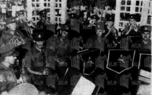
Part of the RA band that gave a concert at the Botanic Gardens11
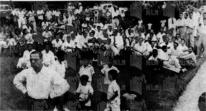
Crowds of people at the Singapore Botanic Gardens listen to the concert by the RA Band.12

Overall, the process of entertainment activities becoming an increasingly central spatial practice within museums also occurs in Singapore’s Botanic Garden. The Gardens hosted weekly music performances that it would stay open longer than usual for, and ‘concerts’ were tracked and monitored in official government reports on the Gardens. These characteristics reveal how, within official discourses, entertainment was considered a dominant spatial practice within the Gardens. Furthermore, national newspapers continuously informed the public of these performances highlighting how the Gardens were also becoming known in popular society through these entertainment practices signalling how entertainment became a critical service within a space, that similar to the museum, was traditionally confined to non-entertainment services. This similarity between the two spaces demonstrates a characteristic that indicates the Singapore Botanic Gardens should be considered Singapore’s first museum.


  1. John Forsdyke, “The Functions of a National Museum,” Journal of the Royal Society of Arts 97 (1949): pp. 506-517, https://doi.org/https://www.jstor.org/stable/41363863, 513. [↩]
  2. Ibid., 514. [↩]
  3. Sarah Longair and John McAleer, Curating Empire (Manchester University Press, 2012), 91. [↩]
  4. Ibid., 82. [↩]
  5. John William Purseglove, “History and Functions of Botanic Gardens with Special Reference to Singapore,” Gardens’ Bulletin Singapore, 1959, pp. 125-154, 125. [↩]
  6. Guide to the Botanical Gardens (Singapore: Government Printing Office, 1889). [↩]
  7. Ibid., 1 [↩]
  8. Annual Report of the Botanic Gardens Department (Singapore: Government Printer, 1950), 4. [↩]
  9. Ibid. [↩] [↩]
  10. “Miscellaneous Column,” Singapore Monitor, March 9, 1985, 18. [↩]
  11. Singapore Listens, Malaya Tribune, November 29, 1948, 8. [↩]
  12. Ibid [↩]

Politics of Semi-Colonial Policing in the Shanghai Municipal Police

The unique political status of extra-territoriality meant the treaty-port city of Shanghai was split into three settlements which were each policed independently by four different police agencies: the Shanghai Municipal Police (SMP) for the International Settlement, the Concession Police for the Frenchtown and the Nationalist Garrison Command’s military police and the Chinese Special Municipality’s public safety bureau.1 Isabella Jackson explores how policing within the SMP was shaped by the opinion that ‘all anticipated threats were Chinese’.2 Police forces partly act to enforce social norms, and this is significant in colonial contexts when social norms were new and artificial.3 Thus, this post argues that the SMP’s heavy-handed tactics towards the ordinary Chinese population evidences an attempt to consolidate Britain’s unofficial influence within Shanghai through reproducing a colonial social hierarchy. The post will demonstrate this by examining the Sikh branch of the SMP. It will use a letter to the editor of the North-China Daily News concerning the behaviour of a Sikh constable towards a Chinese coolie, to evidence the everyday role of the SMP within the Settlement and the everyday low-level violence towards the Chinese population.

In 1892, the North China Herald published a letter from an ‘eyewitness’ addressed to the editor of the North-China Daily News. ((“The Sikh Police,” The North-China Herald, September 16, 1892, 416.)) It recounted the author witnessing a

‘Sikh constable on duty at the corners of Chekiang and Nanking Roads called to the ricsha coolie to stop, walked up to him, struck him with a full blow on the breast, turned him round, kicked him from behind, and then pointed to him to go on the Chekiang road.’ ((Ibid.))

Firstly, the letter evidences the routine police work of the SMP’s Sikh branch. All police have the principal priority of maintaining social order, and the Sikh branch, because of their intimidating physical stature, were tasked with bringing order to the heavy and disorganised traffic within Shanghai’s urban space.4 This spatial distribution of the Sikh constables resulted in them having a constant physical presence in all the busiest areas within the International Settlement. This was significant as they became the most visible and interacted with symbol of British presence in Shanghai.

Alongside the letter exemplifying Sikh constables’ traditional policing roles, the letter’s description of the constable’s violent actions supports Jackson’s observation that ‘Indian constables had a particular reputation for violence’.5 The author expands in their letter to write that they ‘have seen several instances of Sikh policemen maltreating natives’,6evidencing the significant tensions between the Chinese population and the Sikh police. However, unlike the letter suggests, the tension should not be only considered a result of the Sikhs’ nature, as Jackson noted the Sikhs ‘were encouraged [by the SMP] to employ corporal punishment against Chinese.’7This reinforces this post’s exploration of how the SMP had an aggressive attitude toward the Chinese populace; thus, it is unsurprising that their officers replicated this attitude. The SMP’s entrenched discrimination towards the Chinese reflects an attempt to replicate official colonial societies where local populations were subdued to create a social hierarchy to establish urban control. As Jackson explores, there was a ‘racist logic operating in Africa and India that force was required to prevent crime among colonial population’.8 Furthermore, the violence not only being shown by the Sikh branch but also the wider SMP emphasises how the British were attempting to create this social hierarchy and secure their uncertain presence. This is also implied by how the letter was sent by an ‘eyewitness’ suggesting the author wanted to hide their identity, implying unjust violence towards ordinary Chinese was not uncommon within the Settlement, and it may have even been frowned upon for a non-Chinese to find an issue with it.

Furthermore, the letter notes, ‘it is a disgrace to the Model Settlement to have Sikhs knocking people about as they do.’9This suggests how the eyewitness was concerned with the actions of the constable impacting the broader reputation of the Settlement. It illustrates how the police represented the public face for both the Settlement and the British empire, reinforcing how police were considered to embody and enforce the desired social norms of the governing nation. Thus, it is evident why even within the everyday roles of SMP’s officers, there was a significant focus on recreating a colonial hierarchy within society to achieve urban control.

Overall, the letter published in the NCH exemplifies Sikh police brutality towards a Chinese coolie. The violence, as the author indicates was not a unique event. This blog post’s examination of the letter, in conjunction with Jackson’s conclusions on policing in Shanghai, supports how violence towards ordinary Chinese was a common event. However, it more significantly helps to reveal how the violence towards the local population was not only confined to Sikh constables; the SMP encouraged and held an unofficial policy of active discrimination against the local population. This policy reflects a desire to create an illusion of colonialism by replicating the social hierarchy of official colonialism which helped achieve urban control.

  1. Frederic Wakeman, “Policing Modern Shanghai,” The China Quarterly 115 (1988): pp. 408-440, https://doi.org/10.1017/s0305741000027508, 408. [↩]
  2. Isabella Jackson, “Policing and Conflict in Shanghai,” in Shaping Modern Shanghai Colonialism in China’s Global City (Cambridge: Cambridge University Press, 2019), pp. 113-163, 114. [↩]
  3. Robert A. Bickers and Christian Henriot, “Who Were the Shanghai Municipal Police, and Why Were They There? The British Recruits of 1919,” in New Frontiers: Imperialism’s New Communities in East Asia, 1842-1953 (Manchester: Manchester University Press, 2012), pp. 170-191, 173. [↩]
  4. Isabella Jackson, “The Raj on Nanjing Road: Sikh Policemen in Treaty-Port Shanghai,” Modern Asian Studies 46, no. 6 (2012): pp. 1672-1704, https://doi.org/10.1017/s0026749x12000078, 1690. [↩]
  5. Jackson, “Policing and Conflict”, 119. [↩]
  6. “The Sikh Police,”NCH. [↩]
  7. Jackson, “The Raj”, 1691. [↩]
  8. Jackson, “Policing”, 114. [↩]
  9. “The Sikh Police,” NCH. [↩]

Orchid Diplomacy in Singapore’s Botanic Garden

Richard Holttum stated, ‘a botanic garden is essentially a museum of living plants’.1 Its position as a museum is a result of the garden’s double function; it is a place where plants can be studied by experts for science and a place where exhibits occur for the education and recreation of non-experts. Museums are also seen as having a political function and traditionally, the political function of botanic gardens originates from the garden’s position as a colonial construction. However, as this blog post will explore, in the aftermath of World War II and on the advent of Singapore’s independence, the Singapore Botanic Gardens took on a further political dimension as the garden’s award-winning orchids stemmed the beginning of ‘orchid diplomacy’. The prestigious reputation of orchids grown in the Singapore Botanic Gardens allowed the plant to provide a visible, unique symbol of nations’ friendship that was and still is today used as a tool of diplomacy.2

Holttum, who was took on the position as Director of the Gardens from 1925, is credited with the popularization of the technique of orchid hybridisation that facilitated the orchid becoming prestigious.3 However, itwas the international flower shows and exhibitions that placed Singapore’s orchids on the world map. Timothy Bernard explains that when Tan Chay Yan’s hybrid orchid the Vanda won the highest honour in the horticultural world at the Chelsea Flower Show in 1954 it placed ‘Singapore as a powerhouse on the world map of orchid cultivation.’4 The presence of the orchids within international diplomacy soon became national interest with the Sunday Standard reporting that Queen Elizabeth was presented with a bouquet of orchids flown from Singapore to London cultivated at the Botanic Gardens in Singapore.5The gifting of them to one of the most important diplomatic figures of the time, marked by the Queen’s position as Head of the British Empire that ruled over Singapore, evidences how the garden’s orchids had begun to be recognized as an important symbol for the nation within international diplomatic circles. The New Nation also reported how Singapore’s leaders were ‘saying it with orchids’ when welcoming New Zealand’s governmental visitors on their visit to the botanical gardens.6 Again, this exemplifies the plant being used as an offering of friendship within international politics. Alongside orchids being given to important foreign dignitaries, in 1956 following the nation’s independence, Singapore’s Botanic Gardens began the “VIP Orchid Naming” Program at the Gardens. This was an official government practice that named orchids for visiting dignitaries and celebrities such as Michael Jackson.7The timing of this program is also significant it began in the same year Singapore received independence, as Bernard argues the program thus exemplifies an effort from Singapore to ‘enter complex, scientific, economic and diplomatic networks’ that were not controlled or overlooked by their previous colonial rulers.8 The focus on orchids as a symbol that embodied honour and prestige not only in the Gardens but internationally continued into the late 20th century. In 1990, in an interview with The Strait Times, the Chief Executive Director of the new board at the Botanic Gardens, Dr Tan, emphasised that an ‘immediate goal was to get the Orchid Garden at the Botanic Gardens going’.9 The directors believed that this achievement would turn the botanic garden into a ‘national asset’.8This reinforces how still forty years later, the orchids were an emblem that added an additional political function into the Garden, one that impacted within national and international realms.

This blog post’s investigation using newspaper reports and Bernard’s in-depth evaluation of Singapore’s Botanic Gardens reveals how the Garden’s orchids became a symbol of friendship, prestige and honour that was recognized and respected internationally from the 1950s until the present-day. This exemplifies how the space and objects within the Garden took on many functions and how over time different functions were prioritised. If we look beyond the Garden’s traditional definition as an institution of science and consider the space as a ‘living museum’ it helps to discover and explain these differing functions. This specific case of orchid diplomacy suggests that a further investigation of the Singapore Botanic Gardens or other botanic gardens could reveal other examples of the space being used for purposes outside of the gardens traditional scientific role which suggests that it potentially providing an interesting space for a long-essay investigation.

  1. R. E. Holttum, “The Historical Significance of Botanic Gardens in S.E. Asia,” TAXON 19, no. 5 (1970): pp. 707-714, https://doi.org/10.2307/1219283, 707. [↩]
  2. Timothy P. Barnard, Nature’s Colony Empire, Nation and Environment in the Singapore Botanic Gardens (Singapore: NUS Press, 2016), 131. [↩]
  3. Ibid., 127. [↩]
  4. Ibid., 129. [↩]
  5. “Malayan Orchids For The Queen,” Sunday Standard, May 27, 1951, 3. [↩]
  6. “Saying It with Orchids,” New Nation, 1973, 3. [↩]
  7. Barnard, Nature’s Colony, 132. [↩]
  8. Ibid. [↩] [↩]
  9. “Turning National Parks into ‘Global Asset’,” Strait Times, June 9, 1990, 8. [↩]

The Rhetoric of Anti-Conquest in the Dutch’s Island of Paradise

This blog post will explore how Mary Pratt’s argument of imperial nations using an ‘anti conquest’ narrative to disguise their colonial presence is applicable to the Dutch colonial force’s advertisement of Bali as an ‘island of paradise’. As Pratt explains in the chapter ‘Narrating the anti-conquest’ within her book Imperial Eyes: Travel Writing and Transculturation, ‘anti-conquest’ refers to the strategies of representation that European bourgeoisie subjects use to secure their innocence whilst simultaneously asserting European hegemony.1To demonstrate the concept, Pratt explores how naturalists used a rhetoric of ‘anti-conquest’ within their travel writings of the Cape Colony to legitimise imperial powers’ actions and takeovers of the region.2As this blog post will show, in the early 20th century, the Dutch government also adopted an ‘anti-conquest’ rhetoric within their depiction of Bali as a tourist destination through brochures advertising the nation as an ‘island of paradise’ to disguise and hide their aggressive takeover of the island.3

The Dutch conquest of Bali was a lengthy and bloody battle, with the Balinese people proving a tough force to defeat. When Bali was eventually conquered following the death march of the Balinese rajas after the puptans of 1906-8, the Dutch invaded Bali and killed off or exiled much of the population, destroying everything. As Adrian Vickers explores in Bali: A Paradise Created, the Dutch massacres contrasted significantly to the ‘liberal imagination of the Netherlands’ thus, in the aftermath the Dutch government was concerned with how their actions would impact their international standing.2 As a result, the Netherlands were eager to find a way to present their new colony internationally whilst not exposing the nation’s colonial atrocities. This can be seen through their advertisement of Bali as an international tourist destination which can be analysed as an example of Pratt’s concept of an ‘anti-conquest’ rhetoric.

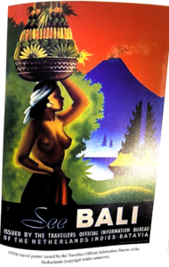
In 1914, only six years after the Klungkung puptan, the first tourist inducements to visit Bali were published. They began with the Dutch steamship, the KPM, issuing the first tourist brochures of Bali. These brochures advertised Bali as the ‘Garden of Eden’, an island that featured ‘jungle scenery,  palm trees and rice fields’ untouched by modernism.4 The brochures communicated an image of Bali that did not refer to any violent or imperial expansionist policies. Instead, they portrayed the Dutch colonisers as the ‘protectors of culture’. The account and ‘gaze’ of Bali that was transmitted as an official discourse suggested and publicised that the Dutch’s presence was uncontested. As one can see from the brochures (see figure. 1 and figure. 2), they intently focus on landscape and nature descriptions. They use visual imagery to remove both the Dutch as European antagonists from the image of Bali and the presence of any indigenous Balinese settlers that opposed the Dutch’s presence. This depiction aligns with Pratt’s ‘anti-conquest’ as the examples of travel writing she explores emphasis that the ‘anti-conquest’ consists of rhetorics that narrate a sequence of sights and seeing that focus on the landscape and minimises the European presence.5 Alongside the ‘anti-conquest’ rhetoric guiding the international ‘gaze’ away from the possibility of any colonial atrocities, Vickers notes that the advertisements were also seen as a way to ease the Dutch’s consciences. It not only allowed them to control the international narrative and image of the island but within official circles helped secured the nation’s innocence.

Figure 1: 1930s travel poster from KPM

Figure 2: 1930s travel poster issued by the Travellers Official Information Bureau of the Netherlands

The brochures not only featured natural landscape and scenery, they also included a significant focus on half-naked Balinese women. This further illustrates the tourist brochures aligning with Pratt’s concept of ‘anti-conquest’. As Pratt explores, the ‘female figure of the “nurturing native”’ has often been a key in sentimental versions of the anti-conquest.6 This figure of the half-baked Balinese woman was so key to the KPM’s tourist advertisements that Bali became known as ‘a land of Woman’.7 Again, this evidences the advertisements promoting a gaze of Bali that depicted the island as a utopia hiding the exploitation or violence that underpinned the Dutch’s presence reinforcing how the advertisements should be seen as an example of Pratt’s concept of ‘anti-conquest’.

In conclusion, as Pratt highlights, it is ‘only through a guilty act of conquest can the innocent act of the anti-conquest be carried out’.8 In the Netherlands’ attempts to absolve themselves of the guilt and potential international backlash that existed from their bloody imperialist conquest, they used tourist brochures to promote a gaze of Bali rooted in the rhetoric of ‘anti-conquest’. Their advertisements of Bali focussed on natural images and the exotic, attractive nature of Balinese women which minimise or avoided the publication of their aggressive European presence and maintained the innocence of Dutch hegemony.

  1. Mary Louise Pratt, Imperial Eyes: Travel Writing and Transculturation (London: Routledge, Taylor & Francis Group, 2017), 58. [↩]
  2. Ibid. [↩] [↩]
  3. Adrian Vickers, Bali: A Paradise Created (Victoria: Penguin Books, 1989), 130. [↩]
  4. Ibid., 131. [↩]
  5. Pratt, Imperial Eyes, 60. [↩]
  6. Ibid., 96. [↩]
  7. Vickers, Bali: A Paradise Created, 132. [↩]
  8. Pratt, Imperial Eyes, 66. [↩]

Peaceful Competition at the Panama Pacific International Exposition

This blog post will investigate the Chinese pavilion at the Panama-Pacific International Exposition in 1915 to illustrate how as David Raizman and Ethan Robey explored in their book, Expanding Nationalisms at World’s Fairs, during the 20th century, nations began to focus on forms of soft power such as design and production rather than arms to demonstrate their power.1 This post explores the expense, positioning, and critique of the Chinese pavilion at the Panama International Exposition to illustrates how nations used their pavilions at expositions as emblems of themselves in formal politics and general society.

The international political context of the Panama-Pacific International Exposition in 1915 was characterised by the opening of the Panama Canal. The canal’s opening shifted global power dynamics by increasing competition in the Pacific. It had made the Pacific easily accessible to China and a space China could begin to compete in. This change in China’s position in the world power standings was subsequently reflected through the excessive grandeur of Chinese pavilion at the Panama exposition. The opening of the pavilion was filled with exorbitant pageantry featuring Qing officials giving various opening day speeches to an extensive crowd.2 As the exposition souvenir guide points out, China ‘appropriated $750,000 and her native artisans to build her pavilion’.((The Souvenir Guide Publishers, Panama-Pacific International Exposition 1915 Souvenir Guide, San Francisco, 1915, 15.)) This expense notably exceeded what other nations, excluding the host, spent on their pavilions. This immense effort that China put into their pavilion illustrates how the Chinese considered the international exposition a crucial place to demonstrate their new power and increasing global presence. This is further implied by how this pavilion contrasted significantly to the previous Chinese pavilion at the international exposition at St Louis in 1904. This was critiqued for the lack of Chinese national symbols and poor exhibition technique and management. It held such minimal significance in China that it was not even organised by Chinese officials but by European and American Chinese Customs Service employees.3This striking difference between the two China pavilions reflects the difference in China’s international position reinforcing how pavilions had become an emblem for nation power within the realm of international politics.

Figure 1. The Souvenir Guide Publishers, Diagram showing Exposition ground plan, Palaces, Courts, Pavilions and Concessions 1915, map, https://babel.hathitrust.org/cgi/pt?id=uc1.31175035173163&view=1up&seq=3&q1=diagram, 20.

The importance of international expositions as a place to display national prestige is also evidenced by how the spatial organisation of expositions reflected the global standings of nations. As Raizman and Robey emphasise, in other expositions, the placement of nations represented the ‘sliding scale of humanity’, and physical objects, such as the central transept at the Great Exhibition in London in 1951, were used to resemble the ‘equator’ and the divide between the West and the East.4The ground plan of the Panama exposition shows the China pavilion in an area characterised by Western nations. It is opposite the pavilions of significant American states such as New York City and is neighboured by Canada. This location aligns with China’s desire to be seen by the international community as a state that held power equivalent to that of the US. Furthermore, the size of the Chinese pavilion is comparable to that of other Western nations, whilst nations that would be defined as being in the ‘East’ such as India and Persia, had smaller spaces. This highlights how the size of pavilions was also used to represent for a nation’s power reinforcing how increasingly not only weaponry represented global power.

The final feature of the Chinese pavilion at the Panama expositions that illustrated how pavilions came to represent nation’s global reputation is seen through the criticism towards the pavilion’s attraction of the Underground Chinatown. At the Underground Chinatown, visitors could view caricatures of opium addicts, performances in opium caves and gambling halls.5 The attraction was met by protests from Chinese officials and the Chinese American community before it was eventually shut down. The critique focussed on the racial and cultural humiliation and, most significantly, how the attraction risked China’s reputation within the international community.6  Within the exposition, they did not want to be considered a ‘lost nation’ for fear of the broader global implications this would create.6 This concern on the impact of China’s international reputation was broadcast in both local American Chinese-language newspapers and Western newspapers. This extensive critique not only from Chinese officials but also, the expatriate community and Western journalists and its focus on the international reputation illustrates how pavilions had become seen as an emblem of the nation.

Overall, the excessive expense of the Chinese pavilion, central positioning and concern that the failings of the pavilion would change the world’s perception of China, illustrate how during the early 20th century new ways to present international power had been created. National pavilions at international exhibitions became representations of countries’ global standings that impacted nationals at home and abroad.

  1. David Raizman and Ethan Robey, Expanding Nationalisms at World’s Fairs: Identity, Diversity, and Exchange, 1851-1915 (Abingdon, Oxon: Routledge, 2018), 8. [↩]
  2. Ibid., 185. [↩]
  3. Raizman and Robey, Expanding Nationalism, 176. [↩]
  4. Ibid., 28 [↩]
  5. Ibid., 188. [↩]
  6. Ibid. [↩] [↩]

The Development of the Notion of Tropicality through European Mapping

This blog post will explore how an evaluation of European mappings of the Tropics illustrates the development of Europeans’ concept of tropicality. As David Arnold notes, tropicality has ‘come to signify the conceptualisation and representation of the Tropics in European imagination and experience.1 Early European mappings produced a notion of tropicality associated with marvel and spectacle. However, when I analysed later maps, the Tropics is presented based on increasingly positivist scientific observations illustrating what Arnold notes as a shift toward ‘scientific tropicality’.2 European perspective of the tropical world was almost exclusively maritime, which meant that their original visions of the Tropics were always from the deck of a ship.3 This distant perspective meant that their tropical mappings often centered the coastline and encompassed a conceived exoticism that suggests, as David Arnold explores, ‘the Tropics were invented quite as much as they were encountered’.4

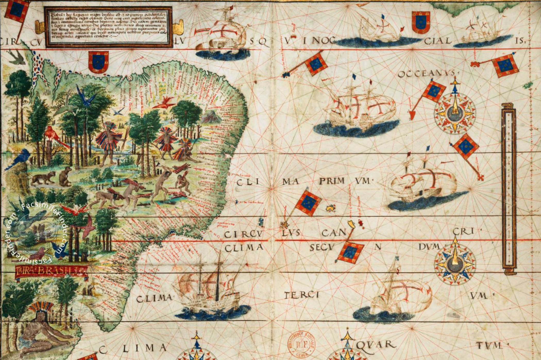
An example of Arnold’s claim that in early Orientalist thought, the Tropics were represented as an exoticised landscape can be seen through Denis Cosgrove’s analysis of the map Terra Brasilis in the Miller Atlas.5 This map was created in 1519, during the second decade of European contact with the Tropics. As Cosgrove notes, the map ‘presents to the European vision a place for witness and wonder, not a place to dwell’.6 The map is entirely pictorial and features scenes of nature and indigenous people. There are varied and exotic trees with many exotic fauna, such as multi-coloured birds, parrots and parakeets.7 The only labels on the map are on the coast, naming ports and bays that could have been areas for colonial conquest. This choice of labelling only potential areas that were relevant for settlement purposes highlights the lack of knowledge early European settlers had towards aspects of the Tropics that were not immediately related to their colonising process illustrating how the European notion of tropicality was based on imagination and a ‘bourgeois vision’.8 As Cosgrove writes, ‘the image is unmistakably tropical’,9 emphasising how it was this pictorial ethnographical type of knowledge that the founded the early European notion of tropicality.


Atlas Miller « Facsimile edition

Terra Brasilis, detail from the Miller Atlas, 1519.

In comparison, Heinrich Berghaus’s map created in 1852 highlights how Europeans’ understanding and the notion of tropicality developed. As Cosgrove explains, Berghaus’s map ‘offers no explicit moral judgements about the various environments and people it represents’.10 It conveys a tropicality based on geographical science rather than pictorial images. The map’s positivist observations highlights how the geographical experiences of Europeans in the Tropics developed the previous imaginative tropicality that was evident in the Miller Atlas. It provides evidence for Arnold’s claim that the notion of tropicality had shifted to involve a more systematic and scientific understanding of the tropics.

Nahrungsweise—Volksdichtigkeit, insert map in Heinrich Berghaus, Geographische Verbreitung der Menschen-Rassen (1852)

Nahrungsweise—Volksdichtigkeit, Heinrich Berghaus, Geographische Verbreitung der Menschen-Rassen (1852)

Comparing these two maps illustrates how Europeans’ visions and understandings of the Tropics developed. Initially, tropical mapping was centered around ‘the romantic constructions of imaginative tropicality’.7 However, as expeditions to the Tropics increased so did knowledge of the Tropics and this was reflected in how mappings and thus the notion of tropicality became more focussed on geographical science.


  1. David Arnold, Tropics and the Traveling Gaze India, Landscape, and Science, 1800-1856 (Seattle (Wash.): University of Washington Press, 2014), 110. [↩]
  2. Ibid., 112. [↩]
  3. Felix Driver, Martins Luciana de Lima, and Denis Cosgrove, “11: Tropic and Tropicality,” in Tropical Visions in an Age of Empire (Chicago: The University of Chicago Press, 2005), pp. 197-216, 202. [↩]
  4. Arnold, Tropics and the Traveling Gaze, p.5. [↩]
  5. Driver, Luciana de Lima, Cosgrove, “Tropic”, p. 204. [↩]
  6. Ibid., 205. [↩]
  7. Ibid. [↩] [↩]
  8. Arnold, Tropics and the Traveling Gaze, p. 6. [↩]
  9. Ibid., 204. [↩]
  10. Driver, Luciana de Lima, Cosgrove, “Tropic”, p. 208. [↩]

The Wide and Straight Street: A Form of Colonial Control

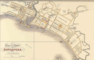
This blog post will focus on investigating how the British colonial powers used urban planning, specifically wide and straight streets, as a form of social control and a way to impose colonial rule. Robert Home’s chapter ‘Planting is My Trade: The Shapers of Colonial Urban Landscapes’ in his book Of Planting and Planning the Making of British Colonial Cities explores how the wide, straight street was a way to impose colonial order upon indigenous culture.1 Home emphasises how, in the 20th century, there was a need to protect colonial cities across the empire against ‘encroachments’ and the British colonial powers saw the ‘straight street’ as a way of more easily detecting and preventing these ‘encroachments’.2 It was such an embedded part of colonial urban planning that street widths were specified in regulations and main roads had a mandatory width of 30-45m.3 This practice of wide and straight streets is evident when examining the primary source of The Jackson Plan for Singapore.4 The plan includes almost exclusively straight streets dividing the city illustrating Jackson aimed to segregate each segment of society to prevent any ‘encroachment’ from banding together and threatening colonial rule. There are also clear divisions for each sector of society, such as the ‘European Town’ or the ‘Chinese Champong’, again allowing the colonial rulers complete control and surveillance of areas that could create resistance. The colonial rulers justified these significant divisions on public health grounds. However, this justification is dubious through examining the traditions of the indigenous population living in Singapore. The indigenous cultures that had lived in the tropics had always favoured narrow streets as they were better suited to the climate. As Home evidences, ‘The Spanish Law of the Indies stated that ‘in cold climates the streets shall be wide; in hot climates narrow’.5 This knowledge had previously enabled the indigenous population to live in Singapore successfully; thus the colonial powers choice to ignore this knowledge illustrates that their justification for the wide roads as a public health measure when tactic to disguise their overarching goal of social control.

Plan of the Town of the Singapore, Lieut Jackson, Survey Department Singapore, Survey Department Singapore (London, 1828).

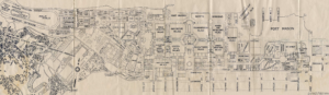
In comparison, the same use of the straight and wide street can also be seen in the colonial cities of Bombay and Calcutta. In Bombay, the Bombay City Improvement Trust controlled development, made new streets, and opened out crowded areas. One of their key projects was the widening of Church Gate Street from 9 to 21 metres.((Robert K. Home, “Port Cities of the British Empire: A Global Thalassocracy,” in Of Planting and Planning: The Making of British Colonial Cities (New York: Routledge, Taylor & Francis Group, 2013), pp. 64-91, 84.)) They also built straight streets to divide the ‘White Bombay’ and ‘Indian Bombay’ as a way to prevent and deter any indigenous opposition.6 Next, in Calcutta, an improvement committee was assigned to ensure that ‘the streets and lanes […] should henceforth be constructed with order and system’.7 The image below shows the imperial capital, and evidences the wide streets that were erected throughout the city in an attempt to keep populations apart. The importance of the layout of these colonial cities and the emphasis on using the streets to ensure ‘order’ again highlights how the British colonial powers were using the city landscape to control the colonised people.

The Central Townscape of Calcutta c. 1930, From A. J. Christopher, The British Empire at Its Zenith (London: Croom Helm, 1988).


Overall, from observing the street layouts in the above maps and images from the colonial cities, Singapore, Bombay, and Calcutta, in the context of Home’s argument the role of the wide straight street becomes clear. It is evident this design was used across the empire as a way to control public space to separate and dismantle societies that could have threatened colonial power. Despite the widening of the streets going against indigenous knowledge of climate control and destroying indigenous spaces, the goal of colonial order and control took priority over resolving any of the hardships caused. 


  1. Robert K. Home, “’Planting Is My Trade’: The Shapers of Colonial Urban Landscapes,” in Of Planting and Planning: The Making of British Colonial Cities ((New York: Routledge, Taylor & Francis Group, 2013), pp. 38-63, 61. [↩]
  2. Ibid., 59. [↩]
  3. Ibid. [↩]
  4. Lieut Jackson, Survey Department Singapore, National Archives of Singapore (London, 1828). [↩]
  5. Home, ‘Planting is my Trade’, 61. [↩]
  6. Ibid., 68. [↩]
  7. Ibid., 71. [↩]

Britishness Abroad: The Shanghai Club

Established by the British settler population in Shanghai in 1873 in the prestigious location of the Shanghai Bund, the Shanghai Club was reported to be the ‘microcosm par excellence of the Settlement.’1 The Club’s membership was the most exclusive in Shanghai and the club was indisputably the space that British male society revolved around. This blog post will use articles from the North China Herald to explore how the Club demonstrated how populations of foreign settlements imported their social hierarchies into Shanghai via their own social spaces. Further, it will also comment on the role of newspapers as historical sources.

The opening of the new building of the Shanghai Club was reported in the North-China Herald on January 7th 1911 as ‘something more than a landmark in the history of a social institution’ .2 as commented in the same article that ‘the founding members of the Shanghai Club had in their mind that it should resemble a segment cut from the home circle’.2 The ‘frontage is certainly the most imposing on the Bund’3 and the ‘design throughout is a rendering of the English renaissance’2 this description of the club highlights the importance and prestige of the Club within the settler population. It further illustrates how the social characteristics of London clubs were transplanted to Shanghai. This desire for the club to resemble ‘the home circle’ stems from as Robert Bicker argues the fear in treaty ports that ‘a community which had compromised its ‘Britishness’ would lose government support.’4 The exterior of the building was a ‘rendering of the English renaissance’ illustrating how the club was designed to be a physical representation of the might of the British Empire and was ‘the most imposing’ in an attempt to intimidate the other surrounding buildings. The Club was used and publicised to transplant the British cultural values as H R Panckridge remarked, ‘for more than a century no institution has been more peculiarly British than a social club’.5 is desire to make the club a symbol of Britishness abroad was also evidenced through how the Shanghai Club unlike the French or American clubs chose to preserve their British exclusivity throughout its existence.6 This specific boundary, through membership rules, between British interaction with other communities and individuals portrays how the club not only aimed to reinforce social hierarchies with the local Chinese population but, also was seen as a space which could be used to cement and perpetuate British political and economic power toward other Western powers.

Newspapers are invaluable sources through which historians can gain a sense of popular opinion and perceptions, the North-China Herald is an excellent English language source for the British settler population in Shanghai. However, due to the commercial motives of newspapers one has to note they can often have political or propagandist agendas leading them to embellish their descriptions and present events in an artificial light. From Bickers’ argument, it is clear that the settler population wanted to be portrayed in a manner that embodied the British imperial characteristics of prestige, strength and exclusivity. The North-China Herald, would have been able to be accessible back in England and was accessible for visiting English dignitaries thus it was an excellent way for the settler population to illustrate their Britishness abroad so they could continue to secure governmental support. This consideration must be included when using these newspaper sources to further investigate the club.

The Shanghai Club, Photo by C.E, Darwent. Taken from: Darwent, C.E, Shanghai: a handbook for travellers and residents to the chief objects of interest in and around the foreign settlements and native city, 1900, p.10.


  1. “Club Land,” The North-China Herald, January 13, 1911, p. 61. [↩]
  2. Ibid. [↩] [↩] [↩]
  3. “Opening of the Shanghai Club,” The North-China Herald, January 13, 1911, pp. 77. [↩]
  4. Robert Bickers, “Chinabound: Crossing Borders in Treaty Port China,” History in Focus, 2006. [↩]
  5. H. R. Panckridge, A Short History of the Bengal Club (Calcutta: Bengal Club, 1927), 1. [↩]
  6. Robert Bickers, “Britons in China: A Settler Society,” in Britain in China: Community, Culture and Colonialism 1900-1949 (Manchester: Manchester University Press, 2017), pp. 67-114, 87. [↩]

Foreigners in Treaty-Port Japan (1859 – 1872)

Foreigners in Treaty-Port Japan (1859 – 1872)

In 1854, with the Treaty of Kanagawa, Japan’s ‘closed country’ sakoku policy was replaced with an ‘open country’ kaikoku policy.1 This open era created new markets, new distribution routes and critically opened new Treaty Port towns. The most significant of these was the Treaty Port of Yokohama. Yokohama’s success and use as trading hub was so significant that it led it to the town being known to be ‘synonymous with the West’.2 John Dower explores how the local Japanese viewed this new commercial hub and their new foreign counterparts through analysing Yokohama prints, Yokohama-e. Yokohama prints were woodblock prints that, during the 19th century, became an extremely popular way to depict Treaty Port towns and depict the actions of the new foreign merchants and traders. This blog entry will explore how the Yokohama prints illustrated; first, the different uses of the new Treaty Port towns, second the lack of knowledge or information the locals had about these new foreigners and, third the suspicion the locals attributed to the foreigners.

One primary source, Utagawa Sadahide’s ‘Pictures of Western Traders at Yokohama Transporting Merchandise’, 1861, will be the principal source for this blog entry; Dower uses it to gain an insight into the different activities within the thriving treaty port harbour in Yokohama. The woodblock depicts five vessels within the bustling Yokohama port and the various tasks that are occurring on them when they are coming into the harbour. The five vessels represent the five nations with bilateral treaties allowing them to use the harbour. Many different activities are occurring within the print, from clerks making notes to crewmen climbing the riggings. These various activities illustrating what Dower calls ‘the unprecedented bustle’3 in the Yokohama harbour and reinforces how Treaty Ports were a hub of trading, business and all the other activities that facilitated Japan’s new international markets. The American ship, denoted by an American flag, includes a long row of small cannons running along the length of their ship.2 The presence of these cannons, Dower views as a ‘subtle touch of the ominous’4, signalling the Japanese’s uncertainty and discomfort with their new open era; they now looked out ‘upon the unknown world of foreign nations’.((Ibid.))Second, most critically, it displays the suspicion attached to foreigners in Yokohama. Locals still were sceptical of the Americans after their aggressive ‘gun-boat diplomacy’ which triggered the kaikou policy. It further illustrates how alongside treaty port towns being a hub of commerce, they were also a place where foreigners could display their naval strength. As Jeremy Taylor explores, the harbour in Yokohama was ‘on occasions lined with foreign troops of all kinds to intimidate Japanese government officials into further concessions’.5

It should be noted that, as Dower argues, it is unlikely that Sadahide was creating this print based on his first-hand view of the harbour. Dower explores how a similar European port scene appeared in the Illustrated London News before the publishing of Sadahide’s print, and this had potentially been the inspiration behind Sadahide’s work. This use of a European source to depict Yokohama’s harbour exposes again the lack of understanding and great uncertainty that Japanese locals and artists had towards these foreign nations and this new influx of trade and chaos. Dower emphasises how often different features of the woodblock prints were a ‘departure from strict reality’.6

Overall, Sadahide’s woodblock print is used by Dower to draw conclusions about the Yokohama local’s impression and interactions with their new foreign counterparts and their attitude towards the new use of their previously quiet village. It is clear the locals viewed their foreign counterparts with caution and uncertainty, often relying on European sources or images to fill their lack of knowledge of the new concepts and people that now surrounded them.


  1. John W Dower, “Yokohama Boomtown, Foreign Community in Treaty Port Japan 1859-1872,’” MIT Visualising Cultures, 2008, https://visualizingcultures.mit.edu/yokohama/yb_essay01.html, 1. [↩]
  2. Ibid., 27. [↩] [↩]
  3. Ibid., 25. [↩]
  4. Ibid. [↩]
  5. Jeremy E. Taylor, “The Bund: Littoral Space of Empire in the Treaty Ports of East Asia,” Social History 27, no. 2 (2002): pp. 125-142, https://doi.org/10.1080/03071020210128364, 137. [↩]
  6. Dower, Yokohama Boomtown, 27. [↩]