Geomantic Warfare: The Japanese General Government Building in Seoul

Gyeongbok Palace was originally built in the 14th century as the centre of Joseon Dynastic rule in Seoul, Korea. The first king of Joseon constructed the palace as both physically and symbolically representative of the auspiciousness of his rule. This, in turn, bolstered the legitimacy of the dynastic change and helped to naturalise the movement of the capital from Kaesong to Seoul.[1] This process was deeply influenced by concepts of pungsu, or ‘geomancy’ in English; “traditional ideas and practices concerning the relationship of human beings with the surrounding environment.”[2] Geomantic ideals were utilised in order to emphasise the good geographic placement of Gyeongbok Palace and of the surrounding landscape to the people, which helped the ruling elites to solidify their power. Following the annexation of Korea in 1910, the Japanese defaced the Gyeongbok Palace site in an attempt to accentuate their own power and naturalise the authority of their colonial rule. Most importantly, they manipulated Korean geomantic ideals to reinforce this, and constructed their General Government Building on the palace grounds.[3] How they engaged in this ‘geomantic warfare’ is what I will explore in this post, making use of historical photographs to do so.

The Japanese colonial government carefully examined the geomantically auspicious sites of Korea, and then ruined and occupied the sites by replacing Korean buildings with Shinto shrines or Japanese government buildings.”[4]

In The Culture of Fengshui in Korea, author Hong-Key Yoon employs the cultural-geographic approach of “reading landscape as a text like a book” to analyse the site of Gyeongbok Palace.[5] Yoon writes about the changes to this cultural site across the 20th century, and examines how ideologies and power relations were built into the meanings taken from these physical geographic changes. Geomantic interpretations were central to this, and Yoon argues these social constructions were used to artificially reinforce popular beliefs about specific landscapes.[6]

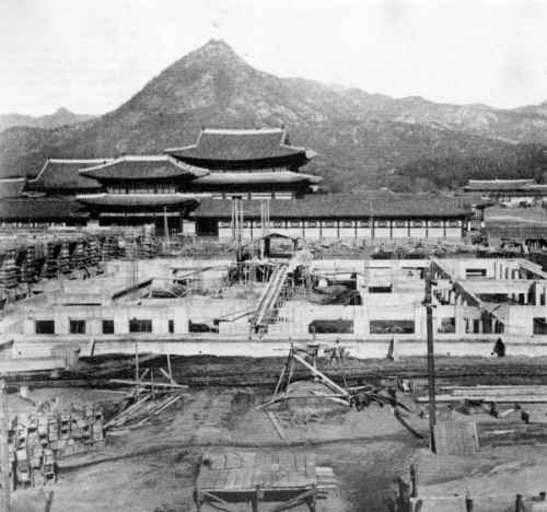
Archival photograph showing the construction of the Japanese General Government Building in front of Gyeongbok Palace.[7]

 The Japanese General Government Building in Seoul was built in 1926 by the Empire of Japan as the central administrative headquarters of their colonial rule over Korea. The building was constructed over the site of Gyeongbok Palace, widely renowned as one of Korea’s most auspicious and important cultural locations. Yoon explains how the Japanese used a method known as ‘palimpsest’ in order to naturalise their new colonial icons. This involves a deliberate comparison of a new “strong” icon against an old “weak” icon.[8] In the case of the Gyeongbok site, the Japanese did not completely replace the Palace with their own building.[9] Rather, they left part of the ruins in place to the back of their new building (an area which, according to geomantic interpretations, is unfavourable). The General Government Building towered over the Palace in both physical height and symbolic strength. This deliberate visual comparison of the two powers represented here had a clear interpretation: Japan was strong, Korea was weak.

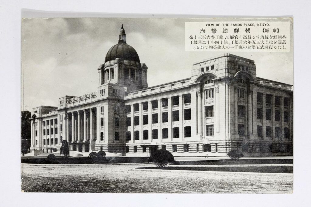
Archival photograph of the former Japanese General Government building located in front of Gyeongbokgung Palace in central Seoul (source: Busan Museum).[10]

 The Japanese were said to have deliberately disrupted the geomancy of the Korean site in an attempt to legitimize their power and de-legitimize Korean nationalism. During the debate in the 1990s over whether the General Government Building should be demolished, there was a widespread public discourse that the building had been the leading weapon in a Japanese plot to deliberately block Korea’s national energy (as encapsulated in the Gyeongbok site).[11] This was proliferated by the discovery of “Japanese spikes” under the site of the building during the demolition process;

These spikes were 20 to 25 centimetres in diameter and 4 to 8 metres in height, and they were tightly packed, about 60 centimetres apart from each other. (Dong-a Newspaper, 29 November 1996).”[12]

A photographic example of similar Japanese spikes supposedly found by activists between 1995 and 2001 in the Jirisan National Park.[13]

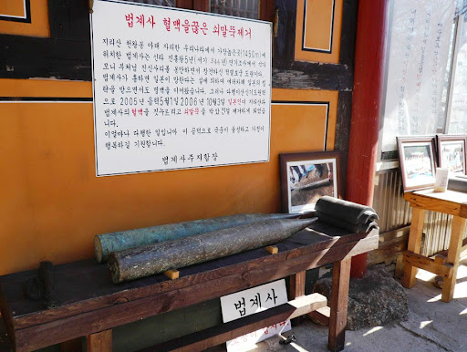
The spikes were driven into the ground supposedly as part of the building’s foundations but, in the mind of the Korean public, they were a purposeful attempt to suppress the “earth-energy” of Joseon’s finest palace.[14] Without the nationalistic geomantic interpretation of what these spikes represented, their findings would have otherwise been of little note to the Korean public. Although, it is important to note that whilst the argument that the Japanese purposefully constructed their General Government building in order to destroy the geomancy of Gyeongbok palace is widely accepted, the argument that Imperial Japan deliberately fixed these iron spikes into the ground as part of this remains controversial.[15] 

Yoon argues that geomancy was not the cause of this battle over the Gyeongbok landscape.[16] Rather, the geomantic interpretations taken from the actions of these two powers (and the buildings represented by them) were used and manipulated in order to achieve various political aims, and to legitimize and de-legitimize support for Imperial Japan in the Korean public mindset throughout the 20th century.


[1] Yoon, Hong-Key, ‘Ch15 Iconographic Warfare and the Geomantic Landscape of Seoul’, in The Culture of Fengshui in Korea: An Exploration of East Asian Geomancy, Lexington Books (1988): p. 283

[2] Han, Jung-san, “Japan in the Public Culture of South Korea, 1945-2000s: The Making and Remaking of Colonial Sites and Memories,” Japan Focus, Vol. 12, Issue 15, No. 2 (2014)

[3] Yoon, Hong-Key, ‘Ch15 Iconographic Warfare and the Geomantic Landscape of Seoul’, in The Culture of Fengshui in Korea: An Exploration of East Asian Geomancy, Lexington Books (1988): p. 277

[4] Ibid, p. 287

[5] Ibid, p. 304

[6] Yoon, Hong-Key, ‘Ch14 The Social Construction of Kaesong,’ in The Culture of Fengshui in Korea: An Exploration of East Asian Geomancy, Lexington Books (1988): pp. 241-42

[7] Booth, Anne, ‘Did It Really Help to be a Japanese Colony? East Asian Economic Performance in Historical Perspective’, Japan Focus, Vol. 5, Issue 5 (2007)

[8] Yoon, Hong-Key, ‘Ch15 Iconographic Warfare and the Geomantic Landscape of Seoul’, in The Culture of Fengshui in Korea: An Exploration of East Asian Geomancy, Lexington Books (1988): p. 281

[9] Han, Jung-san, “Japan in the Public Culture of South Korea, 1945-2000s: The Making and Remaking of Colonial Sites and Memories,” Japan Focus, Vol. 12, Issue 15, No. 2 (2014)

[10] Park, Yuna, ‘Controversy over architectural heritage from Japanese colonial era continues,’ The Korea Herald (Aug 10, 2020) http://www.koreaherald.com/view.php?ud=20200819000642 [Accessed 23/10/21]

[11] Han, Jung-san, “Japan in the Public Culture of South Korea, 1945-2000s: The Making and Remaking of Colonial Sites and Memories,” Japan Focus, Vol. 12, Issue 15, No. 2 (2014)

[12] Ibid

[13] Personal photograph from ‘Did the Colonial Japanese drive Spikes into Sacred Korean Mountains…?’ http://www.san-shin.org/Spikes-controversy.html [Accessed 23/10/21]

[14] Han, Jung-san, “Japan in the Public Culture of South Korea, 1945-2000s: The Making and Remaking of Colonial Sites and Memories,” Japan Focus, Vol. 12, Issue 15, No. 2 (2014)

[15] Ibid

[16] Yoon, Hong-Key, ‘Ch15 Iconographic Warfare and the Geomantic Landscape of Seoul’, in The Culture of Fengshui in Korea: An Exploration of East Asian Geomancy, Lexington Books (1988): p. 304


Bibliography

  • Booth, Anne, ‘Did It Really Help to be a Japanese Colony? East Asian Economic Performance in Historical Perspective’, Japan Focus, Vol. 5, Issue 5 (2007)
  • Han, Jung-san, “Japan in the Public Culture of South Korea, 1945-2000s: The Making and Remaking of Colonial Sites and Memories,” Japan Focus, Vol. 12, Issue 15, No. 2 (2014)
  • Park, Yuna, ‘Controversy over architectural heritage from Japanese colonial era continues,’ The Korea Herald (Aug 10, 2020) http://www.koreaherald.com/view.php?ud=20200819000642 [Accessed 23/10/21]
  • Yoon, Hong-Key, ‘Ch14 The Social Construction of Kaesong,’ in The Culture of Fengshui in Korea: An Exploration of East Asian Geomancy, Lexington Books (1988)
  • Yoon, Hong-Key, ‘Ch15 Iconographic Warfare and the Geomantic Landscape of Seoul’, in The Culture of Fengshui in Korea: An Exploration of East Asian Geomancy, Lexington Books (1988)
  • ‘Did the Colonial Japanese drive Spikes into Sacred Korean Mountains…?’ http://www.san-shin.org/Spikes-controversy.html [Accessed 23/10/21]

Badly Drawn Maps

Badly Drawn Maps and what they can teach us

What makes a good historical map? Do detail and accuracy outweigh aesthetics and simplicity? Alternatively, what makes a bad historical map? Plenty of contemporary pop culture articles find entertainment in examining strange historical maps, assuming their scientific inaccuracy is something comical. But within these ‘inaccuracies,’ can we find historical insight we might have otherwise overlooked? This is the essential question Martin Bruckner seeks to answer. Don’t dismiss a historical map based on assumptions of what makes a ‘good’ or ‘bad’ map, argues Bruckner, rather we should explore why these definitions exist in the first place.

When examining maps, we make various assumptions about the relations of the map: the territory itself as existing independently of the map, north/south being top to bottom, east/west being right to left, and so on.[1] The “old” method of understanding historical maps, according to Bruckner, suggests that ‘good’ maps have unmistakable meanings, and ideals like truth and error are conceptually presented through them. They are the products of empirical science.[2] The map is a representation of a place. Yet, from the 1990s, ‘place’ began to be thought about more broadly, and scholars began treating maps as “subjective representations of social locations and human activities.”[3] This understanding also treats maps as places themselves.

In this view, maps are considered text-specific locales, or sites, shaped by a variety of contexts, ranging from the biography of the mapmaker to the geography of map production to the language of maps.”[4]

For Bruckner, however, our analytic approach to maps should go a step further than this text-based understanding. Historical maps are representations of places deeply endowed with sociality, being both man-made and “man-used.”[5] He argues for considering maps as products of social practice, shaped by all of the aspects that go into their creation; they are moulded by the engraver, painter, ink and paper suppliers just as much as the scholars and librarians who consume them.[6] Similarly, Matt Reeck views maps as “architecture of mind”. He argues they are a dynamic component of a historical process of commerce and settlement: “The advent of good maps is the advent of control over the land…”[7] For Reeck, mobility and movement of peoples is directly connected to cartography, and yet maps too often seek to standardize this; they aspire to “place places outside of time.”[8] Maps are social constructions, they push political agendas and represent societal attitudes. Their creation is often greatly influenced by power interests completely outside of the cartographic industry. Thus, can historical maps truly be deemed either ‘good’ or ‘bad’?


Taking Bruckner’s social approach, empirically ‘bad’ historical maps can now be considered useful and insightful in how they relate to issues other than physical geography. We can provide maps, seemingly objective creations, with historicity and time. Although developed in an American context, Bruckner’s approach can be equally applied to historical maps from East Asia. Examine this 1906 (Meiji 39) map by Japanese cartographer Yamane Akisato:


This atlas page shows 7 maps of various East Asian cities. Included (from left to right) are Hong Kong, Singapore, Vladivostok, Saigon, Bombay, Busan, and Wonsan. The maps show details of the city plan (roads, rivers, railways, etc.), the coastal outline, and major buildings, such as military stations. They are drawn in a simplistic black and white line drawing, which allows for a focus on the layout and structure of the cities and makes them easy to compare. These city maps were published in the atlas in between more detailed and coloured maps and illustrations, and the atlas includes text in both Japanese and Chinese. You may notice that these simple drawings are particularly ‘inaccurate’, or, in the very least, lacking detail. The coastline in the top-centre city (which I assume is meant to be Singapore, although it is difficult to tell) is comically simple, as if included in the compilation as an afterthought. In comparison, the coastlines of Busan and Wonsan on the right are drawn with more extreme detail. Deer Island in Busan’s Bay is especially noticeable, and details of smaller islands and water depth is even included. Although the map of Hong Kong (located far left) is denser, several of the streets are mislabelled in comparison to the reality of their positionality to one another. This strange picking-and-choosing of what details to include and what details to leave out by Akisato, the cartographer, is what makes this map so fascinating. If we now apply Bruckner’s social approach to analysing this map, it opens up the potential for historical interpretation and insight to be gained from it.


Drawn from the Japanese perspective in 1906 (Meiji 39), the map tells us how Japanese citizens might have seen and understood the world, and the importance of other cities in East Asia in comparison to their own. Placing these maps within the historical context of Japan’s activities in 1906, it makes sense for the map of Busan to detail so clearly the coastline and water depth around the city. Busan was a treaty-port which the Japanese held particular influence over around the time this map was published, and in which a strong Japanese presence had existed since the 15th century. Busan was the foothold through which Japanese forces established their control over the Korean peninsula prior to annexation in 1910.[9] It is likely Akisato may have visited Busan directly during his life, although not much is known about the cartographer himself and this is merely hypothetical. Regardless, as a Japanese citizen Akisato would have had, at the very least, more readily available access to information about Busan than to information about Singapore, for example, which was under British colonial control at the time.

More acutely, these maps tell us how Akisato thought these cities should be presented in his atlas, and thus to those learning from his atlas. This highlights what he might have thought relevant, or in this case, not relevant, to be teaching other Japanese consumers about the wider world and about other cities across Asia, especially in comparison to Japan’s own major cities. There is a similar insert page in the same atlas that depicts Tokyo and its surrounding areas, Kyoto, and Osaka. These maps, meant to act as educational tools in the same way as the first 7 we examined above, are extremely dense, showing the grid block layouts of these cities in exact detail.


Considering the Japanese colonial context under which these maps were created once again, we can invoke Bruckner’s social approach to understand why these Japanese cities are presented more carefully. In the book How to Lie with Maps, Mark Monmonier argues that nations often enhance map features that support their point of view on the world and leave out details on the features that sit contrary to this.[10] Is this what is occurring here with Akisato’s atlas? Potentially, but further insight into this would require more research on his career and the publishing details of the atlas itself. At any rate, these maps are shaped deeply by Japanese colonialism and the power relations at play in East Asia in the early 1900s.

J. B. Harley maintains that historians of cartography often simply accept the cartographer’s suggestions of what historical maps are meant to represent, and advocates for greater scrutinization of maps as forms of knowledge creation. [11] The relationship between representation and reality contained within maps affects our relations to and perceptions of the material world, which is all the more pertinent considering a historical context far prior to the information technology era. These historical Japanese maps of various East Asian cities provide a good example of how we can scrutinize as Harley suggests, and they offer a great entry point for further research in this area.


[1] Searle, John. R., ‘Chapter 4: The Map and the Territory,’ in Wuppuluri, S. & Doria, F. A. (eds.) The Map and the Territory, Springer International Publishing (2018): p. 72

[2] Bruckner, Martin, ‘Good Maps, Bad Maps; or, How to Interpret A Map of Pennsylvania,’ Pennsylvania Legacies, Vol. 9, No. 2 (November 2009): p. 40

[3] Ibid, p. 40

[4] Ibid, p. 40

[5] Ibid, p. 40

[6] Ibid, p. 41

[7] Reeck, Matt, ‘A Brief History of the Colonial Map in India – or, the Map as Architecture of Mind,’ Conjunctions, No. 68, Inside Out: Architectures of Experience (2017): p. 185

[8] Ibid, p. 185

[9] Kang, Sungwoo, ‘Colonising the Port City Pusan in Korea: A Study of the Process of Japanese Domination in the Urban Space of Pusan During the Open-Port Period (1876-1910)’, Ph.D. Dissertation, University of Oxford (2012): p. 86

[10] Monmonier, Mark S., How to Lie with Maps, 3rd ed., Chicago: University of Chicago Press (2018): p. 132

[11] Harley, J. B., ‘Deconstructing the map,’ Passages, University of Michigan Library https://quod.lib.umich.edu/p/passages/4761530.0003.008/–deconstructing-the-map?rgn=main;view=fulltext [Accessed 09/10/21]


Primary Sources:

Akisato, Yamane, “Buson, Wonson, Vladivostok, Saigon, Bombay, Hong Kong.” from New Atlas & Geography Table (Bankoku chin chizu chiri tokeihyo), Nakamura: Shobido, Meiji 39 (1906) https://www.davidrumsey.com/luna/servlet/detail/RUMSEY~8~1~313791~90082699:Buson–Wonson–Vladivostok–Saigon-?sort=Pub_List_No_InitialSort&qvq=q:vladivostok;sort:Pub_List_No_InitialSort;lc:RUMSEY~8~1&mi=11&trs=12# [Accessed 08/10/21]

Akisato, Yamane, “Tokyo and environs, Kyoto, Osaka.” from New Atlas & Geography Table (Bankoku chin chizu chiri tokeihyo), Nakamura: Shobido, Meiji 39 (1906) https://www.davidrumsey.com/luna/servlet/detail/RUMSEY~8~1~313790~90082700:Tokyo-and-environs–Kyoto–Osaka?sort=Pub_List_No_InitialSort&qvq=q:author%3D%22Akisato%2C%20Yamane%22;sort:Pub_List_No_InitialSort;lc:RUMSEY~8~1&mi=21&trs=36 [Accessed 10/10/21]

Prostitution in Trade Cities

Upon Matthew Perry’s expedition to Japan, the country was opened to the rest of the world in the late nineteenth century. Following British victory in the First Opium War, the UK successfully ended the Canton system opening up other areas of China to trade in 1872. With this new space opened to trade, the process of developing industry and all factors to accompany it would be a topic of much contention for both sides. However, in this early ambiguity and chaos, many illicit industries were stimulated including the sex industry within these areas to supply services to a growing detached and mobile male population.[1]

Following Perry’s expedition, unequal treaties were negotiated with Japan giving Western powers the upper hand. The Japanese adapted quickly with widespread education and literacy as well as economic changes to help Japan match its Western counterparts in this new era. Thus, the increasingly successful nation attracted many people to its newly opened cities. As practical details were still being ironed over, the legal grey areas enabled the growth of prostitution within these trade cities. Yokohama was one such city where Historian Foster Rea Dulles stated by 1865 ‘five hotels, twenty-five grog shops, and an unrecorded number of brothels in the foreign settlement [Yokohama]’.[2] Thus, the idea of this chaotic trade city as one of much vice and sin was a popularly expressed concern seen in the protests of many English clerics. However, it continued to flourish until government intervention decades later.

This theme of debauchery was also echoed in Shanghai in the late nineteenth and early twentieth century. As Shanghai was opened to Westerners in 1872 upon the end of the First Opium War, the city became the perfect place for the sex industry to flourish with lacking contagious diseases acts like those in Hong Kong and the extraterritorial rights of Europeans. Thus, women trickled into the country to fill this demand. Here, they were able to make in some cases, a quite generous livelihood. However, after the 1890s this ‘golden age’ of prostitution had come to an end with Qing officials pushing Western powers to crackdown.[3] This manifested itself in legislation like that enacted in Singapore in 1890, and on encouragement of the League of Nations saw the deportation of such women in the early 1930s from Singapore and in 1932 from Hong Kong.[4] This was partly fueled by religious groups who saw these practices as distasteful and contributed to consuls abstaining from overseeing disputes in such affairs and instead directing them to the courts.

Prostitution was able to flourish in these chaotic new trading cities opened up between East and West. Ambiguous legal and moral conditions in the beginning to mid-nineteenth century facilitated such growth as trade continued to develop in newly opened areas.

[1] Eileen P. Scully, ‘Prostitution as a Privilege: The “American” Girl of Treaty-Port Shanghai, 1860-1937’, in the International History Review 20 (1998), p. 876

[2] John W. Dower, ‘Yokohama Boomtown: Foreigners in Treaty-Port Japan (1859-1872)’, MIT Visualizing Cultures, MIT

< https://visualizingcultures.mit.edu/yokohama/yb_essay02.html> [accessed on 10 December 2019]

[3] Eileen P. Scully, ‘Prostitution as a Privilege’, p. 869

[4] Ibid., pp. 869-70

Heterotopias within French and Japanese Imperialism

As Michael Foucault details, heterotopias are places of mixed experiences, representing the existence of different expectations and meanings for different groups.[1] While this is a model that can be applied to a variety of other spaces, it visibly manifests in imperial ambitions of both French Hanoi and Japanese Manchukuo. In both cases, leaders albeit with different motivations, pursued the construction of ‘modern’ cities in these areas ignoring the existing people and structures in place already. Despite efforts to adapt to different terrain with architectural changes, in the end, both efforts failed due to a variety of reasons.

The leaders overseeing Manchuria’s development into a Japanese territory saw it as an ideal blank page, one which would be a model for slow to change Japanese society and cities back home. Repression evident in events like mass resignations of staff at Kyoto University in 1933 saw Japanese social reformers looking to use imperial additions as a canvas to model the changes they imagined but could not implement at home.[2] The French saw Hanoi as another imperial location necessary to expand its empire. Influenced by the discourse around tropical architecture, sanitation, and contagion theory, Hanoi saw rapid urban expansion and the implementation of sanitation laws in the early twentieth century part of  France’s larger imperial agenda.[3]

The Japanese pursued a similar expansive agenda, with the development of industry, railways lines and technology evident in the prestigious symbolism the Asia Express came to represent.[4] They framed the development of Manchukuo as the creation of a new ideal Japanese city. Additionally, an elaborate tourism industry saw travel passes on increasingly expanding rail lines into far towns, touring to see Chinese ‘exotic’ markets and the newly created modern cities creating a dichotomy between a Chinese past and the Japanese future.[5] In a similar vein, the French developed Hanoi’s European quarter on the vision of a renovated Vietnamese city, improved by Western sanitation and urban planning.[6] French construction saw colonizers tackling issues of how to build houses suited to the foreign climate, similarly to how the Japanese borrowed Manchurian designs in their hamlet planning.[7] This reflected the different motives with the Japanese pursuing construction of a model Japanese city in Manchukuo to encourage reforms at home while the French sought to extend their imperial power in Hanoi to boost their world standing.

Additionally, both powers showed a disregard for existing structures. In Manchukuo, the distance between the Chinese and Japanese populations was attempted, although it failed as it did not practically consider labor needs.[8]  The French’s European quarter remained isolated and reserved for European immigrants despite the use of local labor in its construction. Thus, the complex sewage system within it served as a symbol of European victory over germs and their success in the area.[9] When rat hunts broke out in 1902, French powers used the local population as the rat-hunting workforce, a move capitalized on by the latter. Thus, French powers were duped by their dismissal of the local existing structures of people, climate and pests.

Both cases show imperial ambitions attempting to cultivate and create a utopian city model for colonizers to enjoy. While both ultimately fail in part because of their disregard for the existing structures in place, they also create concrete examples of Foucault’s heterotopias. Both reflect utopian dreams for imperial ambitions and the inaccessible nature of that dream.


[1] Michael Foucault, Of Other Spaces: Utopias and Heterotopias (PUBLISHER 1984), p. 4

[2] Louise Young, Japan’s Total Empire: Manchuria and the Culture of Wartime Imperialism, Twentieth-Century Japan (University of California Press 1999), p. 255

[3] Laura Victoir and Victor Zatsepine, Harbin to Hanoi: The Colonial Built Environment (Hong Kong 2014), p. 2

[4] Young, Japan’s Total Empire, p. 245

[5] Ibid., p. 274

[6] Michael G. Vann, ‘Of Rats, Rice, and Race: The Great Hanoi Rat Massacre, an Episode in French Colonial History’, in French Colonial History 4 (2003), p. 192

[7] David Turner, Crossed Histories Manchuria in the Age of Empire (University of Hawaii Press 2005), p. 57

[8] Ibid., p. 54

[9] Vann, ‘Of Rats, Rice, and Race’, pp. 193-94