Educating Japan: How the Public Health Train was able to Meet the Demands of a Time Conscious Population.

Trains within Japan are an important factor in life because they meet cultural standards which ensure efficient time and promote a work lifestyle. However, due to how integrated trains have become in the everyday life of Japan, they have become spaces which people use for socializing and practicing social etiquette. Trains are also a vital source of advertising and educating, therefore, therefore, allowing the idea of the ‘Public Health Train’ to be established. In 1947, the public health train was used as an exhibit to educate people on issues such as nutrition, dental hygiene, and how diseases can spread. What this train also provided were details of employment within the medical field.1 This train would tour Japan, which allowed an estimated number of 900,000 people to view the exhibit and be granted a better understanding of their own health. Although this train only toured Japan for two years, it changed how space within trains can be used, not only for transportation, but as a source of vital information.

Not only was the space within the train used for education, but by placing this type of exhibit within Japanese train stations, it ensured that it was within the route of workers and students who would have perhaps missed the opportunity to view the exhibit if the exhibit had been placed elsewhere. Therefore, what can be argued is that the public health train was only successful because it met the cultural demands of Japan. By placing the exhibit within a train station, it became accessible to busy workers and students who were expected to comply with strict time schedules.

‘An impressive and colourful ceremony was held November 1 at Harajuku Station, Tokyo, Japan, in commemoration of the opening of the Public Health Train exhibits. The train then moved out to its first three-day stand at Tokyo Central Station and was host to more than 15,000 persons during this period.’2

Alisa Freedman’s Tokyo in Transit: Japanese Culture on the Rails and Road highlights what could be referred to as the waiting culture within Japanese train stations because of how accustomed people had become to using train stations as meeting points and primary methods to get to work or school.3 Therefore, what can be noted is why features such as shops, restaurants, and exhibits were normalized within this space. The notion of waiting allowed this space to be used in a way that would occupy people who were waiting.

Train stations within Japan were and still are a space that occupies perhaps the largest amount of people waiting and this is perhaps why using an exhibit within the form of a train seemed most appealing to its audience. This type of exhibit might have worked within America’s subways or Paris’s metro stations, but not as successfully as in Japan and this is because spatial factors have ensured that cities have room to accommodate the popularity of cars as a means of transport, therefore creating a decline within the usage of trains. Whereas Japan’s narrow streets disenable the prospect of cars becoming high in demand. Therefore, allowing trains, buses, and bicycles to remain the main mode of transport.

  1. Public health and welfare in Japan (1939-1949) p.77. []
  2. Weekly bulletin, Supreme Commander for the Allied Powers. Public Health and Welfare Section (1947) p.7. []
  3. Alisa Freedman, Tokyo in Transit: Japanese Culture on the Rails and Road (Stanford University Press, 2011) p.11. []

The extended domestic space: the construction of nursing homes in pre-war Japanese society

Foucault’s The Birth of Clinic and Discipline and Punish triggered criticism and reflection on the institutions such as hospitals and mental asylum. The architectural design and administrative formats in these places were criticized for restricting and stripping the basic dignity of human beings. It is a similar case for nursing homes.

The history of the nursing home can be traced to the construction of poorhouses in England in the seventeenth century. It was specifically designed to contain and care for the marginal social collectives since, at that time, hospitals started to exclude the obstetrical, indigent, and insane patient, as well as lepers and children.1 Nursing homes originated from hospitals, which explains why their later construction and design adopted the structure of hospitals. The position of nursing homes in society is similar to hospitals as well. According to Roger Luckhurst’s chapter on prison, asylum and hospital in his work on Corridors, these places possess the characteristic of alienation, isolating from the social and familial environment.2 However, nursing homes in Japan in the pre-war time showed opposite attributes. They tended to recreate the domestic space for the aged through architectural construction and the arrangement of daily activities. In my long essay, I plan to focus on this unique characteristic of the nursing home in Japan.

The motivation for developing social institutions in Japan was similar to that of other Western countries (which is to take care of the life of the elderly), but the existence of nursing homes could be viewed as an exceptionally unusual case in East Asian countries which respected Confucianism as the dominant guideline for social behaviour and hierarchy. Taking care of the elders and seniors is the responsibility of the younger generations in a family. In Mika Toba’s report on the biographies of residents in a nursing home in pre-war Japan, we could know that most of them were people who either did not have a child or lost their child before coming to old age.  This sometimes even became a condition for the people who wanted to apply for residence in a nursing home. The Tokyo nursing home, which I mainly focused on, had a hut called “Family hut” (家庭寮). It was explicitly built for elderly people who still had family members of the same generation to live together. The set-up of the rooms in the family hut was intentionally designed in the same way as typical Japanese houses, “the structure of the hut only changes a little compared to a normal house. At the middle of the tatami room, there is a hibachi”.3 Not only was the physical construction made to be more similar to a traditional Japanese house, but the timetable arrangement also contained the intention to recreate everyday life regardless of following the concept of ‘nursing home’. Most of the hours in a day were designated to devote to housework. The timetable of the nursing home also aimed to give the aged as much freedom as possible. As long as the residents do not have a serious health issue, they have the freedom to go out.

Figure 1: the residents in the Tokyo nursing home receiving gifts from female students (caption on the left side: the visit of the female students delights elderly people)

Unlike the alienating nature of the hospital and mental asylum, the nursing home in Japan was closely connected with society. The Tokyo nursing home held regular visiting activities. In its anniversary book, there is a picture (figure 1) showing young students sending elderly people gifts. The arrangement of student visiting could be seen as compensation for the childless life of those elderly people. Since a Confucianist society operates on family units, these childless old people were seen as the social marginals included in the relief law enacted in 1932. The Japanese welfare system was established based on a family-like society. Nursing homes did not merely operate as shelters or medical supporting institutions for the elderly people in need, but instead as substitutions of a family for them.

Examining the domesticity in nursing homes on a broader scale, the development of the nursing home in Japan also marked the attempt of contemporary Japanese to explore an alternative way of Asian modernization instead of following the trajectory of the West. The first nursing home established in Japan was called St. Hilda nursing home and was operated by a Christian group in Japan. After the promotion of the Meiji emperor to support the people who needed social welfare in 1868, the number of nursing homes increased, and many of them were run by local religious groups, especially Pure Land Buddhism. The process of making the nursing home more like a domestic space reflects the attempt to seek an alternative path for the modernization of Japan on a social and domestic level. There is a relationship between the construction of the nursing home and the building of a modern Asian society based on the tenet of benevolence and Confucianism. Just like Jordan Sand argues that there was the dissolution of tradition and emphasis on domestic life, and the occurrence of this turn of dwelling and domestic spaces in the late Meiji and early Taisho period when Japan fully participated in global imperial competition was not just a coincidence.4

  1. Renée Rose Shield, Uneasy Endings: Daily Life in an American Nursing Home, Uneasy Endings (Cornell University Press, 2018), p.30-31. []
  2. Roger Luckhurst, Corridors: Passages of Modernity (London: Reaktion Books, 2019), p.190. []
  3. 東京養老院, ‘養老 : 東京養老院概要’ (東京養老院, 1938), p.76-77. []
  4. Jordan Sand, House and Home in Modern Japan: Reforming Everyday Life 1880-1930 (Cambridge, Mass.; London: Harvard University Press, 2005), p. 4-5. []

Prisons as Internal and External Space: The cases of Lushun and Seodaemun


The study of prisons from a spatial aspect is an interesting one. There are the architectural studies, which analyse the shape of a building and never begin without first referring to the famous Bentham Panopticon, then there are the multitude of ethical and moral studies, as well as philosophical, historical, legal, the list goes on.

For my essay I am focussing specifically on two prisons under Japanese rule, Seodaemun in Korea and Lushun in Dalian (Manchuria, formerly Port Arthur). Both are brilliantly covered in Shu-Mei Huang and Hyun Kyung Lee’s work Heritage, Memory and Punishment: Remembering Colonial Prisons in East Asia. Their work covers all aspects of prisons, showing how prison architecture in east Asia developed through Western influences. Crucially, they show how this evolved not just in an architectural sense, but also in line with legal, judicial and penal reform itself.

What I am most interested in is the difference in prisoner treatment between Seodaemun and Lushun. As Huang and Lee state, Lushun was not originally built as a Japanese prison, but taken over after the defeat to Russia in the Russo-Japanese War in 1905. The plans for the prison had originally been drawn up by the head of the Russian Pacific Fleet, and so there is a clear visual demarcation in the architecture denoting the extent of the original Russian construction and the later Japanese additions.1 This is important to keep in mind, as Lushun was used to hold the captured Russian prisoners of war after 1905. Perhaps this was an attempt at keeping the prisoners aware of their defeat, but the accounts of those held there show that they were treated remarkably well. I argue that the location of Lushun in Manchuria is central to this, as it was seen as an already contested space- having gone variously through Russian, Chinese and Japanese control. Furthermore, the Russo-Japanese War was Japan’s first global conflict, and so Lushun represented Japan’s willingness to abide by the relatively new European treaties of human rights. I therefore argue that the treatment of prisoners in Lushun was not a case of Japan’s magnanimity to their fallen enemies, but a deliberate ploy to be viewed as civilised and modern by the rest of Europe, in order to prove their ‘enlightenment’ and modernisation.

The proof is clear when contrasted against the conditions and treatment of prisoners in Seodaemun prison. Unlike Lushun, Seodaemun was constructed by the Japanese imperial government after the signing of the Japan-Korea Protectorate Policy in 1905, which formally brought Korea under Japanese control2. It was therefore a clear symbol of Japanese Imperialism and their view of Japanese superiority. Huang and Lee argue that it was designed specifically to hold ‘“dangerous figures” such as political offenders’, with the ‘”objective” [own emphasis] of separating them from society’3. I argue that it was this viewpoint of the Japanese as superior to the Koreans that explains the mistreatment of those held in Seodaemun prison. Taking the spatial angle, it is clear that Seodaemun, being located in Korea and fully under Japanese control, was thus perceived as an ‘internal’ space compared to Lushun’s ‘external’ space.

  1. Shu-Mei Huang and Hyun Kyung Lee, Heritage, Memory and Punishment: Remembering Colonial Prisons in East Asia, Oxon, 2020, p. 57 []
  2. Ibid, pg. 76 []
  3. Ibid, pg. 77 []

Forward planning: A comparison of population control in Manchuko and the Taiping Heavenly Kingdom

A common thread with ideas of Utopian cities is the importance of planning, especially town planning. In the context of Manchuko, these Utopian ideals were made possible through its conception as an entirely new city, a literal blank slate from which to build a perfect regime. However, as with all concepts of Utopia dreamt up so far, what seems perfect on paper is always difficult if not impossible to make reality.

Take two examples of a Utopian ideal: Manchuko, an area of China under Japanese control, and the Taiping Heavenly Kingdom of Korea. Both are examples of a Utopian ideal that aimed to create a perfect world order according to the leader’s ideas. Both enjoyed a large degree of success in their formative years, and yet both ended up struggling to maintain that order as the cities grew.

The greatest similarity I found between these two examples is that of housing and the settlement structure. Both were designed around a rigid system of strictly controlled numbers for houses, whereby the entire population was compartmentalised into numerical blocks of houses, streets, villages, and districts. The aim in both was to instil a sense of duty and order in the inhabitants as well as create stronger bonds. I argue that while this may have been the case for some, this tightly controlled system of planning set itself up for failure from the beginning as both cases failed to take proper account of population demographics and long-term planning.

Let’s compare the statistics. David Tucker sets out the numbers for Manchuko in his chapter City Planning Without Cities: Order and Chaos in Utopian Manchuko. Accompanied at every stage with clearly labelled diagrams, he shows the proposed outline of Manchuko. It was ordered into a system of hamlets, with each one surrounded by fields and woodland and bordered by a gated wall and moat1. Each hamlet consists of a community building with a central plaza, and rows of houses arranged around it. Each one would have 150 houses, with each household comprising 5 people and allotted 15 acres of fields. The scale then ascended with 3 hamlets forming a village of 450 households of 2250 people2.

Tucker states that these numbers were very carefully chosen as it was based on an assumption that 150 households of 5 people each would mean an average of about 200 working-age men to provide labour, who would be equally split between guarding and agricultural duties. The designation of 3 hamlets into a village would be enough to provide “a sufficient economic base for shared educational, cultural and administrative facilities”3

These numbers were roughly the same in the Taiping Heavenly Kingdom. Instead of villages, families were grouped together into 25 households, although the size of each household was not regimented4. What sets it apart from Manchuko is the religious aspect. As the name suggests, the Taiping Heavenly Kingdom was a religious organisation, and so the fundamental doctrine is very different from the economic foundation of Manchuko. Perhaps the most striking difference is Taiping’s absolute segregation of the sexes and total prohibition on sex even between married couples, punishable by death5. This appears to have been far more of a religious order than any attempt at population control, and in any case was dropped after the inevitable loss of morale.

What does need to be considered is the sheer scale of population that both Manchuko and Taiping had to plan for. At it’s height, Manchuko had a population of 300,0006. A sizeable number, but comparatively easier to plan for. Taiping, on the other hand, had at its greatest height up to 2 million people7. This is of course impossible to verify and includes people on the periphery who may have proclaimed themselves a follower but not actually lived in a Taiping-controlled city. Nevertheless, the numbers speak for themselves.

In both cases, then, it was not so much a case of a lack of planning, but of fundamental population oversights. Both Manchuko and Taiping were founded on a basis of control of growth; economic for Manchuko and religious for Taiping. For Manchuko, the tightly regimented, perfect-on-paper outline could never have worked in reality as it failed to account for pretty much all aspects of population demographics. Such strictly controlled numbers of households and villages may have seemed like it could have been added to as required, but it takes an all-or-nothing approach and so does not account for the ‘in-between’ stages. Especially for a campaign that aimed to entice Japanese citizens to move in huge numbers, it would have required huge levels of pre-emptive statistics to be able to successfully house the numbers they required and neatly sort people into such a system.

Taiping, in the same vein, placed huge importance on proselytising and enticing new converts. In this sense, it is a contrast to Manchuko as there was far more planning for the governmental and political control than on a daily level, with far vaguer outlines for the distribution of land and labour. The emphasis was on communal life, but without the same kind of structural, regimented divisions seen in Manchuko.


Both Manchuko and Taiping are therefore brilliant case studies of the difficulty an urban planner faces in trying to marry a Utopian ideal with the lived reality of the human population. Manchuko arguably enjoyed a greater degree of success due to the smaller population overall, while Taiping could not cope with the sheer overwhelming scale of its devotees. It would thus be interesting to take this discussion further, perhaps in a longer essay than the scope of a blog post allows.

  1. Tucker, David “City Planning Without Cities: Order and Chaos in Utopian Manchukuo” in Mariko Asano Tamanoi (ed)., Crossed Histories: Manchuria in the Age of Empire, p. 60 []
  2. Ibid, p. 61 []
  3. Ibid []
  4. Wm. Theodore de Bary (ed), Sources of Chinese Tradition, pg. 225 []
  5. Reilly, Thomas H. The Taiping Heavenly Kingdom: Rebellion and the Blasphemy of Empire, University of Washington Press, 2011, p. 142 []
  6. Tucker, pg. 53 []
  7. Philip A. Kuhn. “The Taiping Rebellion” in Cambridge History of China, p. 275 []

Confucianism and urban planning in Changchun as the capital city of Manchukuo 1932-1937

When Zeng Guofan, the famous scholar and leader of the Hunan Army in the late Qing period, successfully took back Nanjing from the Taiping Heavenly Kingdom, one of the most prioritised tasks in his reconstruction plan was to build Confucian temples.1 Interestingly, Japanese colonialists’ naming of the newly constructed areas and its promotion of Confucian shrines and rituals of worshipping Confucius happened about sixty years later in Changchun coincidentally echoes with Zeng’s plan in Nanjing. In this blog, I will argue that Confucianism profoundly integrates with urban construction in Changchun, the capital city of Manchukuo, due to the reason that Confucianism is important to prove one’s legitimacy of ruling in China. It could consolidate the rule and is an essential alternative for the Japanese to construct a utopia in the urban spaces in Asia. Also, I want to address an exceptional characteristic possessed by Confucian temples, a form of unity in Lefebvre’s space of triad theory. The perceived, conceived space, perceived space and the space practised in a Confucian shrine reach a harmonious unification. This is one of the reasons why Confucian temples were preferred by a regime to build to consolidate its rule.

https://www.davidrumsey.com/luna/servlet/detail/RUMSEY~8~1~328360~90096829?qvq=q%3A%3D%22Manshu%CC%84koku%20Kokumuin%20Kokuto%20Kensetsukyoku%22%3Bsort%3APub_List_No_InitialSort%2CPub_Date%2CPub_List_No%2CSeries_No%3Blc%3ARUMSEY~8~1&mi=1&trs=2

In order to find the trace of Confucianism in Changchun, I found a map with a detailed construction plan of Changchun. It was published in 1936 in Xinjing, another name for Changchun. As shown in the map, the names of the locations in the city centre were excerpted from Confucian classics. For example, Anmin street got its name from “Shuntian anmin” which means following the will of Heaven and bringing peace to the people.2

Since Confucianism was the most fundamental ideology for the rulers of China, it forms the most fundamental part of China’s social and administrative systems. In pre-modern China, to enter the administrative system, one must learn the classical text of Confucianism and then takes the civil examination to become a government official. On the social aspect, Confucianism assigns everyone who lives in the society a role to fulfil, like Confucius’s famous saying, “There is government when the prince is prince, and the minister is minister; when the father is father, and the son is the son.” Confucianism is the foundation for the order of society and the nation.

In the early 1930s, establishing order and control in Changchun was one of the most critical tasks for Guandong Army and the Manchukuo government after the Manchurian incident, and therefore Confucianism came to the front stage of Changchun. By looking into the historical context, we could know that in 1932, Japan was urgent to prove its legitimacy in China. In the North China Herald, published on 7 September 1932, there was an article with the title “Expedition to Manchukuo?” that reported the claim made by the Chinese government in Nanjing to take back Manchuria and the gathering of Soviet troops near the border of Manchukuo.3

In this map, these names excerpted from Confucian classics are particularly marked out, but buildings and locations such as the Ministry of Culture and Education and State Council were left out. They were only written in the columns printed beside this map. Actually, these government institutions were either located around Datong square or along Shuntian streets. The map tended to explicitly emphasise these public facilities, which were named after Confucianist ideology. The integration of Confucianism in the urban construction of Changchun entrusted Manchukuo and the Manchukuo government’s wishes that Manchukuo could become a prosperous and harmonious modern state under the teaching of Confucianism without following the trajectory of the west. Ironically, the order in Manchukuo, specifically in Changchun, was still maintained by Guandong Army.4

The other significance of the map is that it missed marking the location of Confucian shrines in Changchun. The most prominent Confucian shrine in Changchun is located near The Entertainment Place (歡樂地) on the map. Though many landmarks were named after Confucian classics, the map still overlooked one of the most critical things in practising Confucianism. It confirms what Yishi Liu argues in his article that from 1937 Confucian worshipping gradually lost its status in Manchukuo, as the Ministry of Culture and Education, which was in charge of worshipping Confucius, was reduced to a bureau and merged into the Ministry of Civil affairs.5 The promoted ritual of worshipping became the worshipping of Amaterasu. However, back in 1932, the ritual of worshipping Confucian was advocated by the first Prime Minister of Manchukuo Zhen Xiaoxu and supported by Guangdong Army, the true authority in Manchukuo.6 There was a trend of deterioration of the popularity of Confucianism in Changchun in the late 1930s when the Japanese gradually started to gain a more stable position in Northern China.

Finally, I want to argue that Confucian shrines are a space where the perceived, the conceived, and the practices could reach harmony without creating any unpredicted situation or function. Confucian shrines are built for worshipping Confucius; besides the rituals hosted by government officials or even the emperor, sometimes normal people could also go to the shrine for the same purpose. With thousand years of teaching Confucianism, the meaning of space and its ideology behind space became monolithic. An example of the construction in Changchun which created huge differences between the practices of the space and the space conceived is the National Founding University (Kendai) in Changchun, which was built as a pan-Asianist institution to breed the leader of future generations who would lead the revival of East Asia. But this eventually resulted in disillusionment amongst the best educated and highly expected people toward the nation-founding ideals, and some even turned themselves against the Japanese.7 Many secret anti-Japan activities were active in Kendai, such as the forbidden-book reading association. Compared to Kendai, Confucian shrines were a very ‘stable’ space with less probability of cultivating dangerous thinking or activities against Japanese colonial authorities. Confucian shrines, for hundreds of years, only had one straightforward function: to worship Confucius. With their close connection with the ruling class, and under the supervision of Guangdong Army8, it could be seen as a unified space of perceived, conceived and practised as a tool for the consolidation of the regime.

  1. Wooldridge, Chuck. City of Virtues: Nanjing in an Age of Utopian Visions (2015) Ch 4 “Zeng Guofan’s Construction of a Ritual Center, 1864-72”, p. 118. []
  2. Liu, Yishi. “Competing Visions of the Modern: Urban Transformation and Social Change of Changchun, 1932-1957.” Ph.D., University of California, Berkeley, 2011, p.103 []
  3. “Expedition to Manchukuo,” The North-China Herald, September 7, 1932. []
  4. Liu, Yishi. “Competing Visions of the Modern”, p. 62. []
  5. Ibid, p.73. []
  6. Ibid, p.69. []
  7. Liu, Yishi. “Competing Visions of the Modern”, p.24-25. []
  8. Ibid, p.69-70. []

Imperial Tourism: A Comparison of Japanese Postcards of Colonial Korea

Spatial politics were central to the maintenance of Japan’s imperial empire.[1] A historical examination of tourism allows for analysis of how territory and geographical space were stabilised in the imagination of the Japanese public during the early 20th century. This blog post will explore the potential for understanding postcards as representative of historical mobility across this geographical space, both imagined and real. It will demonstrate this through comparing Japanese depictions of Korea through picture postcards produced in the colonial period. The arguments and ideas put forward in this post will form the basis of a longer analytical essay, and thus will aim to introduce the topic, highlighting potential areas for further development and synthesis.

“[Postcards] seem like shards of flash-frozen reality compacted into two dimensions, putative proof of having been there and seen that. They move over various forms of distance and time, while carrying with them ephemeral yet precious moments or sights to be appreciated, and then possibly forgotten.”[2]

There is a tendency in historical academia to treat postcards straightforwardly as either merely an embellished form of communication or simply a visual record, in much the same way as historical photographs. Whilst postcards do provide a valuable pictorial insight into the past, Hyung Gu Lynn argues that frequently scholars focus on the “aesthetic elements of the image” of postcards and neglect the socio-political context which an examination of their creation, distribution, and reception can allude to.[3] I argue that postcards inhibit both a sense of traversing space and traversing time. The sender of the postcard has travelled to an ‘unfamiliar’ space in order to purchase and post it back home. This is implicit in the meaning taken from the physical postcard itself, but also in the spatial imaginary it creates of the places photographed; thus the postcard has traversed space. Likewise, due to the nature of the postal service there is a passing of time between the act of the sender posting the card and it being received at its intended location; thus the postcard has traversed time. As Lynn states: “the postcard allowed for a journey into the afterglow of the recent past.”[4]

With this understanding, I will now compare three postcards of colonial Korea that, when analysed together, present a narrative of Japanese rule that emphasises colonial modernity. They are taken from the collection “The Views of Keijo.” Originally a 32 postcard set from the 1940s, only 29 of the postcards survive today.[5] The three postcards below all depict colonial Korea, but in dramatically different lights. Lynn argues that known changes to the urban landscape helps to place postcards (that often go undated) in time.[6] For example, the Government General Building in Seoul, Korea, was the subject of many postcards following its construction in 1926, as can be seen in the postcard below:

[7]

This postcard emphasises the modern architecture of the Government General Building, which sits on the previous site of the Korean Gyeongbok Palace. The demolition of valuable Korean historical and geomantic sites was a key facet of the Japanese occupation. In particular, new and modern Japanese buildings were located strategically and purposefully on old Korean sites. Part of the previous site was often left in ruins alongside the colonial site to demonstrate Japanese superiority.[8] These archaeological areas were then constructed into tourist spots, allowing the Japanese to select a specific representation of premodern Korean culture and civilisation to show the wider public.[9] The second postcard demonstrates this, depicting Gyeonghoeru Palace Hall:

[10]

In the picturing of these two locations in the format of postcards, Japanese forces could demonstrate to the wider Japanese, Korean, and international public their colonial strength and achievements, as well as transforming premodern Korea into a voyeuristic object rather than a lived reality. Combined, this created colonial Seoul as a desirable tourist destination.

In contrast, the third postcard shows the Korean neighbourhood located outside Seoul’s East Gate:

[11]

Postcards such as this, which displayed the thatched roofs of a Korean neighbourhood, helped to reassert a discourse of progress, or lack thereof, through comparison of these spaces with ‘modern’ Japanese buildings.[12] According to these postcards, which were placed alongside one another in a collection, modernity is presented as a result of colonial rule. This narrative implies the upward development of Japanese innovation in comparison to the illustrations of Korean society as in stasis.[13] Furthermore, the Korean people pictured in the postcards become themselves the object of touristic voyeurism and attraction.[14]

“This set of postcards nicely represents three themes typically encountered by Japanese visitors to Korea around 1940, namely examples of modernity introduced by the Japanese, evidence of Japanese efforts to preserve examples of Korea’s “once advanced civilization,” and evidence of the still primitive contemporary native culture.”[15]

Moreover, Lynn argues that colonial postcards “helped portray the colony as a place that was desirable because of its distance, its picture postcard exoticism.”[16] Through postcards, the imagined space of colonial Korea became closer to the Japanese metropole centre, and movement between the two was implied as easily achieved through modern technologies such as ship, rail, and post. At the same time, these postcards painted Korea as consisting of people culturally different (read: backwards) compared to the Japanese people receiving the cards at home.

There are several potential analytical areas around historical postcards which, if developed, would provide further insight into how they are representative of spatial mobility. For instance, the majority of postcards in surviving archival records are cards that remained unsent, likely being donated as a collection.[17] This speaks to the purpose of the cards as beyond simply stationary or for communicative means, suggesting they were tokens worth collecting and preserving. This, however, begs the question; is there more value to those historical postcards which were posted? In terms of examining their mobility, does the act of the postcard itself physically crossing geographical distance (and their rarity now) make it more valuable of study than those which were simply bought and collected? Such questions provide a useful starting point for further academic investigation of the topic.


[1] MacDonald, Kate (2017) Placing Empire: Travel and the Social Imagination in Imperial Japan, Oakland: University of California Press, p. 2

[2] Hyung Gu Lynn (2007) ‘Moving Pictures: Postcards of Colonial Korea,’ IIAS Newsletter, 44: 8

[3] Ibid, p. 8

[4] Ibid, p. 8

[5] Ruoff, Kenneth J. (2010) ‘Touring Korea,’ in Imperial Japan at Its Zenith: The Wartime Celebration of the Empire’s 2,600th Anniversary, Cornell University Press, p. 109

[6] Lynn (2007) p. 8

[7] The Government General Building in Seoul, taken from the collection “The Views of Keijo,” as in Ruoff, Kenneth J. (2010) ‘Touring Korea,’ in Imperial Japan at Its Zenith: The Wartime Celebration of the Empire’s 2,600th Anniversary, Cornell University Press, p. 110

[8] Yoon Hong-Key (1988) ‘Iconographic Warfare and the Geomantic Landscape of Seoul,’ in The Culture of Fengshui in Korea: An Exploration of East Asian Geomancy, Lexington Books, p. 281

[9] Ruoff (2010) p. 109

[10] Gyeonghoeru Palace Hall, taken from the collection “The Views of Keijo,” as in Ruoff, Kenneth J. (2010) ‘Touring Korea,’ in Imperial Japan at Its Zenith: The Wartime Celebration of the Empire’s 2,600th Anniversary, Cornell University Press, p. 110

[11] Korean residential neighbourhood in colonial-era Seoul, taken from the collection “The Views of Keijo,” as in Ruoff, Kenneth J. (2010) ‘Touring Korea,’ in Imperial Japan at Its Zenith: The Wartime Celebration of the Empire’s 2,600th Anniversary, Cornell University Press, p. 111

[12] Lynn (2007) p. 9

[13] Ibid, p. 9

[14] Ruoff (2010) p. 111

[15] Ibid, p. 111

[16] Lynn (2007) p. 9

[17] Ibid, p. 8

Sato and Sand: A Curious Case of Primary Sources and Japanese Kitchens

Just as I cook rice in a rice cooker, some choose to use a pot over a gas stove. Japan is one such country that has transitioned from traditional wood fires, to gas, and finally electric rice cookers in the short span of two centuries. Although the rice cooker is now a quintessential item in many parts of East Asia, its history is often quite obscure and difficult to trace. Historical scholarship on the rice cooker, especially in English, appears to be quite sparse, save for Jordan Sand’s impressive account of Japanese kitchens in the Meiji Era.

A researcher on the topic would be hard pressed to turn to Japanese language sources, and rightly so. The famous insularity of Japanese research, and indeed Japanese publications as a whole means that much of the Japanese research done on the evolution of their kitchen culture is locked behind a language barrier. The result of this research existing in different realms to that of the rest of the world has produced some interesting results. Both Jordan Sand and the author of a short Japanese article in Jūtaku Kenchiku, The Housing Journal for Builders and Designers, written by Keisuke Sato (佐藤敬介) draw on similar sources to give the reader a snapshot of the kinds of technology available in kitchens during the Meiji and Taisho eras, alongside the technological innovations that changed the Japanese kitchen during this period. [1] At some points of the cross analysis of these two sources, I had to stop and question whether these were the same authors with different names, or even the possibility that Sato (due to his article being written in 2012 as opposed to Sand in 2005), had either read Sand’s work and taken inspiration or just plain plagiarised it. It only after taking a closer look at the latter parts of Sato’s article that made it apparent that both authors had chanced upon the same sources and used them in each of their respective works. Even so, it was quite startling that the narrative trajectories that each author took were so similar. From references to similar articles, to discussions of gas technology in the kitchen, and even the changing spatial nature of the “sitting to standing” role of the cook in the kitchen. It was completely flabbergasting to see almost the same topics being discussed, just in slightly different ways.

Analyzing a 2012 Japanese publication of Jūtaku Kenchiku, provided interesting insight into how kitchen technologies as a whole shifted significantly during different periods of Japan’s modernization. Sato does some excellent primary source research based on first-hand accounts of interviews and images taken from magazines throughout the Meiji and Taisho Era. Curiously, both Sato and Sand cite “Shokudōdraku” and use the exact same image from the kitchen of a certain Count Ōkuma Shigenobu. Funnily enough, the only difference in the image is that the 2012 Japanese rendering has colour, whereas Sand’s does not. Both took note that there was a large UK imported gas cooker and the implications that had on the function of this kitchen and of the shifting spatial forms in the Japanese kitchen in this era. [2] It is likely that the reason why both authors chose the image was because it was the best representation of the inner workings of a Meiji Era kitchen in an aristocratic household and provided insight into the types of appliances that were used. Perhaps it was just sheer chance that they came upon the exact same source and image, or perhaps this particular subfield of the spatial history of kitchens in Japan is so sparse that they there are few good examples to choose from. Whichever it is, it is most curious that both secondary sources converge at this specific image.

Sato’s use of ōkuma’s kitchen


Sand’s use of ōkuma’s kitchen

 
Whereas Sand comments on the bourgeoise nature of consumption. Sato appears to take a much more empirical and indeed personal approach to these representations in the kitchen, instead commenting on how specific appliances seem to have made the lives on housewives easier, alongside specific measurements in the form of Tsubo (the size of about 2 tatami mats) for the kitchen. [3] The easiest way to explain the differences in explanation for the exact same source would simply be the audience each author was writing for. Sand would be more interested in creating an account that was more consistent with academic forms of research that required theoretical analysis, whereas Sato was more interested in creating a practical account for those that wanted to draw inspiration from historical forms of the kitchen. You can see the split between the historical analysis and the contemporary comments on how to structure your kitchen based on change in content about halfway through Sato’s article.

Curiously, Sato appears to delve more into the quotidian aspects of kitchen life in his accounts. He took his research a step further by introducing accounts of a certain 工學博士清水家 (The House of Shimizu, Doctor of Engineering) during the Taisho era. Commenting on specific developments in gas technology that allowed “meals to be put in front of 17 people within the span of 30 minutes”. [4] These kinds of empirical accounts seemed to be of less interest to Sand as they didn’t serve to support the overarching narrative of the transformation of the Japanese woman in the kitchen. Sand’s concerns regarding the “laboratisation” of the kitchen was something that wasn’t quite discussed as much in Sato’s account, as well as accounts by other articles on kitchens that were present in an earlier 1981 article published in Jūtaku Kenchiku.

While both took different approaches to spatial practices in the kitchen and the various forms this took, there was a marked interest in gas as an innovation in kitchen technology and the transition from “sitting to standing” in the kitchen. Sato’s introduction of gas focused more on the gradual integration in Japanese society, from street-lamps in Ginza, to the advent of the gas water heater in the 35th year of Meiji. [5] Once again, similar references to gas appliance manuals and the ability of gas technology being “lit by a single match” appears. This section of Sato’s article is the only part that vaguely comments on the cleanliness of gas as an energy and cooking source, citing the lack of soot and dirt being healthier to the organs and eyes. Sand on the other hand, focuses on how gas appliances could replace the “unhygienic maid” in the search for modernity. [6] The transformation of the kitchen from a sitting to standing space was something that both authors paid very close attention towards. Sand discussed differences in the Kantō and Kansai kitchens and how the two stepped kitchens of many older models and rural environments. [7] The way that he comments on the “streamlining” of the kitchen from many individuals (such as maids and other helpers) to the single housewife was somewhat echoed by Sato, in much less specific forms. Specific references to “Taylorism” were even made by both authors as justifications for making the kitchen a space that was more “laboratory like” (to borrow Sand’s term). 


The point at which the two authors begin to diverge is in discussions of the applications of these innovations to the modern kitchen. Sato draws on his own experiences in modelling kitchens from the late 1970s to the modern day and makes certain references to an ideal “kitchen triangle” between the stove, sink and fridge in the modern home. [7] Sand ends his chapter with the main narrative point of the transformation of the kitchen as a space in Meiji Japan being a reflection of the bourgeoisie, hygiene and educational norms that were beginning to pervade throughout Japanese society. [8] The comparisons of these two pieces of research has aroused a certain sense of uncanniness that is sure to be of interest to any historian. The kinder hypothesis would be that both authors chanced upon the same primary sources and analysed them in different ways. This is possible as Sato intersperses primary source research from other accounts throughout his article. The much harsher criticism would be that Sand’s original analysis was used and repackaged for a domestic journal on kitchen design by Sato.

[1] Keisuke Sato, Daitokoro no Rekishi, Jūtaku Kenchiku432: 4 (April 2012) pp. 23-27.

[2] Jordan Sand, House and Home in Modern Japan: Architecture, Domestic Space and Bourgeois Culture, 1880-1930. (Massachusetts, 2004.)

[3] Keisuke Sato, ‘Daitokoro no Rekishi’, p. 23.

[4] Ibid, p. 23.

[5] Ibid, p. 25.

[6] Sand, House and Home, p. 78

[7] Keisuke Sato, ‘Daitokoro no Rekishi’, p. 25

[8] Sand, House and Home, p. 79


Geomantic Warfare: The Japanese General Government Building in Seoul

Gyeongbok Palace was originally built in the 14th century as the centre of Joseon Dynastic rule in Seoul, Korea. The first king of Joseon constructed the palace as both physically and symbolically representative of the auspiciousness of his rule. This, in turn, bolstered the legitimacy of the dynastic change and helped to naturalise the movement of the capital from Kaesong to Seoul.[1] This process was deeply influenced by concepts of pungsu, or ‘geomancy’ in English; “traditional ideas and practices concerning the relationship of human beings with the surrounding environment.”[2] Geomantic ideals were utilised in order to emphasise the good geographic placement of Gyeongbok Palace and of the surrounding landscape to the people, which helped the ruling elites to solidify their power. Following the annexation of Korea in 1910, the Japanese defaced the Gyeongbok Palace site in an attempt to accentuate their own power and naturalise the authority of their colonial rule. Most importantly, they manipulated Korean geomantic ideals to reinforce this, and constructed their General Government Building on the palace grounds.[3] How they engaged in this ‘geomantic warfare’ is what I will explore in this post, making use of historical photographs to do so.

The Japanese colonial government carefully examined the geomantically auspicious sites of Korea, and then ruined and occupied the sites by replacing Korean buildings with Shinto shrines or Japanese government buildings.”[4]

In The Culture of Fengshui in Korea, author Hong-Key Yoon employs the cultural-geographic approach of “reading landscape as a text like a book” to analyse the site of Gyeongbok Palace.[5] Yoon writes about the changes to this cultural site across the 20th century, and examines how ideologies and power relations were built into the meanings taken from these physical geographic changes. Geomantic interpretations were central to this, and Yoon argues these social constructions were used to artificially reinforce popular beliefs about specific landscapes.[6]

Archival photograph showing the construction of the Japanese General Government Building in front of Gyeongbok Palace.[7]

 The Japanese General Government Building in Seoul was built in 1926 by the Empire of Japan as the central administrative headquarters of their colonial rule over Korea. The building was constructed over the site of Gyeongbok Palace, widely renowned as one of Korea’s most auspicious and important cultural locations. Yoon explains how the Japanese used a method known as ‘palimpsest’ in order to naturalise their new colonial icons. This involves a deliberate comparison of a new “strong” icon against an old “weak” icon.[8] In the case of the Gyeongbok site, the Japanese did not completely replace the Palace with their own building.[9] Rather, they left part of the ruins in place to the back of their new building (an area which, according to geomantic interpretations, is unfavourable). The General Government Building towered over the Palace in both physical height and symbolic strength. This deliberate visual comparison of the two powers represented here had a clear interpretation: Japan was strong, Korea was weak.

Archival photograph of the former Japanese General Government building located in front of Gyeongbokgung Palace in central Seoul (source: Busan Museum).[10]

 The Japanese were said to have deliberately disrupted the geomancy of the Korean site in an attempt to legitimize their power and de-legitimize Korean nationalism. During the debate in the 1990s over whether the General Government Building should be demolished, there was a widespread public discourse that the building had been the leading weapon in a Japanese plot to deliberately block Korea’s national energy (as encapsulated in the Gyeongbok site).[11] This was proliferated by the discovery of “Japanese spikes” under the site of the building during the demolition process;

These spikes were 20 to 25 centimetres in diameter and 4 to 8 metres in height, and they were tightly packed, about 60 centimetres apart from each other. (Dong-a Newspaper, 29 November 1996).”[12]

A photographic example of similar Japanese spikes supposedly found by activists between 1995 and 2001 in the Jirisan National Park.[13]

The spikes were driven into the ground supposedly as part of the building’s foundations but, in the mind of the Korean public, they were a purposeful attempt to suppress the “earth-energy” of Joseon’s finest palace.[14] Without the nationalistic geomantic interpretation of what these spikes represented, their findings would have otherwise been of little note to the Korean public. Although, it is important to note that whilst the argument that the Japanese purposefully constructed their General Government building in order to destroy the geomancy of Gyeongbok palace is widely accepted, the argument that Imperial Japan deliberately fixed these iron spikes into the ground as part of this remains controversial.[15] 

Yoon argues that geomancy was not the cause of this battle over the Gyeongbok landscape.[16] Rather, the geomantic interpretations taken from the actions of these two powers (and the buildings represented by them) were used and manipulated in order to achieve various political aims, and to legitimize and de-legitimize support for Imperial Japan in the Korean public mindset throughout the 20th century.


[1] Yoon, Hong-Key, ‘Ch15 Iconographic Warfare and the Geomantic Landscape of Seoul’, in The Culture of Fengshui in Korea: An Exploration of East Asian Geomancy, Lexington Books (1988): p. 283

[2] Han, Jung-san, “Japan in the Public Culture of South Korea, 1945-2000s: The Making and Remaking of Colonial Sites and Memories,” Japan Focus, Vol. 12, Issue 15, No. 2 (2014)

[3] Yoon, Hong-Key, ‘Ch15 Iconographic Warfare and the Geomantic Landscape of Seoul’, in The Culture of Fengshui in Korea: An Exploration of East Asian Geomancy, Lexington Books (1988): p. 277

[4] Ibid, p. 287

[5] Ibid, p. 304

[6] Yoon, Hong-Key, ‘Ch14 The Social Construction of Kaesong,’ in The Culture of Fengshui in Korea: An Exploration of East Asian Geomancy, Lexington Books (1988): pp. 241-42

[7] Booth, Anne, ‘Did It Really Help to be a Japanese Colony? East Asian Economic Performance in Historical Perspective’, Japan Focus, Vol. 5, Issue 5 (2007)

[8] Yoon, Hong-Key, ‘Ch15 Iconographic Warfare and the Geomantic Landscape of Seoul’, in The Culture of Fengshui in Korea: An Exploration of East Asian Geomancy, Lexington Books (1988): p. 281

[9] Han, Jung-san, “Japan in the Public Culture of South Korea, 1945-2000s: The Making and Remaking of Colonial Sites and Memories,” Japan Focus, Vol. 12, Issue 15, No. 2 (2014)

[10] Park, Yuna, ‘Controversy over architectural heritage from Japanese colonial era continues,’ The Korea Herald (Aug 10, 2020) http://www.koreaherald.com/view.php?ud=20200819000642 [Accessed 23/10/21]

[11] Han, Jung-san, “Japan in the Public Culture of South Korea, 1945-2000s: The Making and Remaking of Colonial Sites and Memories,” Japan Focus, Vol. 12, Issue 15, No. 2 (2014)

[12] Ibid

[13] Personal photograph from ‘Did the Colonial Japanese drive Spikes into Sacred Korean Mountains…?’ http://www.san-shin.org/Spikes-controversy.html [Accessed 23/10/21]

[14] Han, Jung-san, “Japan in the Public Culture of South Korea, 1945-2000s: The Making and Remaking of Colonial Sites and Memories,” Japan Focus, Vol. 12, Issue 15, No. 2 (2014)

[15] Ibid

[16] Yoon, Hong-Key, ‘Ch15 Iconographic Warfare and the Geomantic Landscape of Seoul’, in The Culture of Fengshui in Korea: An Exploration of East Asian Geomancy, Lexington Books (1988): p. 304


Bibliography

  • Booth, Anne, ‘Did It Really Help to be a Japanese Colony? East Asian Economic Performance in Historical Perspective’, Japan Focus, Vol. 5, Issue 5 (2007)
  • Han, Jung-san, “Japan in the Public Culture of South Korea, 1945-2000s: The Making and Remaking of Colonial Sites and Memories,” Japan Focus, Vol. 12, Issue 15, No. 2 (2014)
  • Park, Yuna, ‘Controversy over architectural heritage from Japanese colonial era continues,’ The Korea Herald (Aug 10, 2020) http://www.koreaherald.com/view.php?ud=20200819000642 [Accessed 23/10/21]
  • Yoon, Hong-Key, ‘Ch14 The Social Construction of Kaesong,’ in The Culture of Fengshui in Korea: An Exploration of East Asian Geomancy, Lexington Books (1988)
  • Yoon, Hong-Key, ‘Ch15 Iconographic Warfare and the Geomantic Landscape of Seoul’, in The Culture of Fengshui in Korea: An Exploration of East Asian Geomancy, Lexington Books (1988)
  • ‘Did the Colonial Japanese drive Spikes into Sacred Korean Mountains…?’ http://www.san-shin.org/Spikes-controversy.html [Accessed 23/10/21]

Badly Drawn Maps

Badly Drawn Maps and what they can teach us

What makes a good historical map? Do detail and accuracy outweigh aesthetics and simplicity? Alternatively, what makes a bad historical map? Plenty of contemporary pop culture articles find entertainment in examining strange historical maps, assuming their scientific inaccuracy is something comical. But within these ‘inaccuracies,’ can we find historical insight we might have otherwise overlooked? This is the essential question Martin Bruckner seeks to answer. Don’t dismiss a historical map based on assumptions of what makes a ‘good’ or ‘bad’ map, argues Bruckner, rather we should explore why these definitions exist in the first place.

When examining maps, we make various assumptions about the relations of the map: the territory itself as existing independently of the map, north/south being top to bottom, east/west being right to left, and so on.[1] The “old” method of understanding historical maps, according to Bruckner, suggests that ‘good’ maps have unmistakable meanings, and ideals like truth and error are conceptually presented through them. They are the products of empirical science.[2] The map is a representation of a place. Yet, from the 1990s, ‘place’ began to be thought about more broadly, and scholars began treating maps as “subjective representations of social locations and human activities.”[3] This understanding also treats maps as places themselves.

In this view, maps are considered text-specific locales, or sites, shaped by a variety of contexts, ranging from the biography of the mapmaker to the geography of map production to the language of maps.”[4]

For Bruckner, however, our analytic approach to maps should go a step further than this text-based understanding. Historical maps are representations of places deeply endowed with sociality, being both man-made and “man-used.”[5] He argues for considering maps as products of social practice, shaped by all of the aspects that go into their creation; they are moulded by the engraver, painter, ink and paper suppliers just as much as the scholars and librarians who consume them.[6] Similarly, Matt Reeck views maps as “architecture of mind”. He argues they are a dynamic component of a historical process of commerce and settlement: “The advent of good maps is the advent of control over the land…”[7] For Reeck, mobility and movement of peoples is directly connected to cartography, and yet maps too often seek to standardize this; they aspire to “place places outside of time.”[8] Maps are social constructions, they push political agendas and represent societal attitudes. Their creation is often greatly influenced by power interests completely outside of the cartographic industry. Thus, can historical maps truly be deemed either ‘good’ or ‘bad’?


Taking Bruckner’s social approach, empirically ‘bad’ historical maps can now be considered useful and insightful in how they relate to issues other than physical geography. We can provide maps, seemingly objective creations, with historicity and time. Although developed in an American context, Bruckner’s approach can be equally applied to historical maps from East Asia. Examine this 1906 (Meiji 39) map by Japanese cartographer Yamane Akisato:


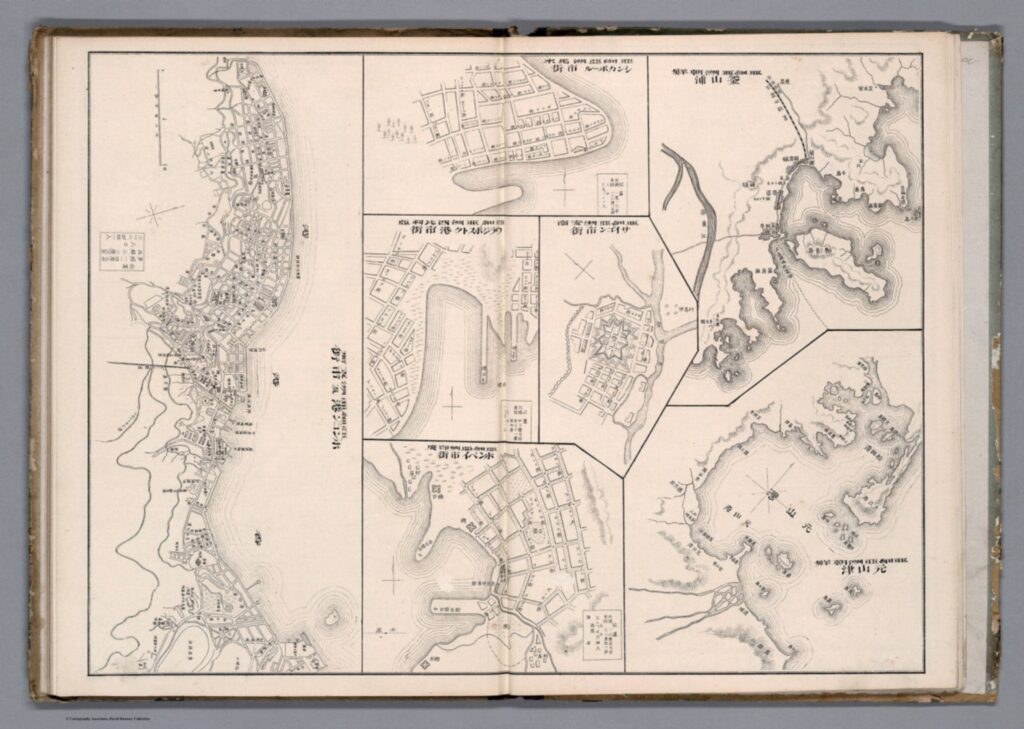
This atlas page shows 7 maps of various East Asian cities. Included (from left to right) are Hong Kong, Singapore, Vladivostok, Saigon, Bombay, Busan, and Wonsan. The maps show details of the city plan (roads, rivers, railways, etc.), the coastal outline, and major buildings, such as military stations. They are drawn in a simplistic black and white line drawing, which allows for a focus on the layout and structure of the cities and makes them easy to compare. These city maps were published in the atlas in between more detailed and coloured maps and illustrations, and the atlas includes text in both Japanese and Chinese. You may notice that these simple drawings are particularly ‘inaccurate’, or, in the very least, lacking detail. The coastline in the top-centre city (which I assume is meant to be Singapore, although it is difficult to tell) is comically simple, as if included in the compilation as an afterthought. In comparison, the coastlines of Busan and Wonsan on the right are drawn with more extreme detail. Deer Island in Busan’s Bay is especially noticeable, and details of smaller islands and water depth is even included. Although the map of Hong Kong (located far left) is denser, several of the streets are mislabelled in comparison to the reality of their positionality to one another. This strange picking-and-choosing of what details to include and what details to leave out by Akisato, the cartographer, is what makes this map so fascinating. If we now apply Bruckner’s social approach to analysing this map, it opens up the potential for historical interpretation and insight to be gained from it.


Drawn from the Japanese perspective in 1906 (Meiji 39), the map tells us how Japanese citizens might have seen and understood the world, and the importance of other cities in East Asia in comparison to their own. Placing these maps within the historical context of Japan’s activities in 1906, it makes sense for the map of Busan to detail so clearly the coastline and water depth around the city. Busan was a treaty-port which the Japanese held particular influence over around the time this map was published, and in which a strong Japanese presence had existed since the 15th century. Busan was the foothold through which Japanese forces established their control over the Korean peninsula prior to annexation in 1910.[9] It is likely Akisato may have visited Busan directly during his life, although not much is known about the cartographer himself and this is merely hypothetical. Regardless, as a Japanese citizen Akisato would have had, at the very least, more readily available access to information about Busan than to information about Singapore, for example, which was under British colonial control at the time.

More acutely, these maps tell us how Akisato thought these cities should be presented in his atlas, and thus to those learning from his atlas. This highlights what he might have thought relevant, or in this case, not relevant, to be teaching other Japanese consumers about the wider world and about other cities across Asia, especially in comparison to Japan’s own major cities. There is a similar insert page in the same atlas that depicts Tokyo and its surrounding areas, Kyoto, and Osaka. These maps, meant to act as educational tools in the same way as the first 7 we examined above, are extremely dense, showing the grid block layouts of these cities in exact detail.


Considering the Japanese colonial context under which these maps were created once again, we can invoke Bruckner’s social approach to understand why these Japanese cities are presented more carefully. In the book How to Lie with Maps, Mark Monmonier argues that nations often enhance map features that support their point of view on the world and leave out details on the features that sit contrary to this.[10] Is this what is occurring here with Akisato’s atlas? Potentially, but further insight into this would require more research on his career and the publishing details of the atlas itself. At any rate, these maps are shaped deeply by Japanese colonialism and the power relations at play in East Asia in the early 1900s.

J. B. Harley maintains that historians of cartography often simply accept the cartographer’s suggestions of what historical maps are meant to represent, and advocates for greater scrutinization of maps as forms of knowledge creation. [11] The relationship between representation and reality contained within maps affects our relations to and perceptions of the material world, which is all the more pertinent considering a historical context far prior to the information technology era. These historical Japanese maps of various East Asian cities provide a good example of how we can scrutinize as Harley suggests, and they offer a great entry point for further research in this area.


[1] Searle, John. R., ‘Chapter 4: The Map and the Territory,’ in Wuppuluri, S. & Doria, F. A. (eds.) The Map and the Territory, Springer International Publishing (2018): p. 72

[2] Bruckner, Martin, ‘Good Maps, Bad Maps; or, How to Interpret A Map of Pennsylvania,’ Pennsylvania Legacies, Vol. 9, No. 2 (November 2009): p. 40

[3] Ibid, p. 40

[4] Ibid, p. 40

[5] Ibid, p. 40

[6] Ibid, p. 41

[7] Reeck, Matt, ‘A Brief History of the Colonial Map in India – or, the Map as Architecture of Mind,’ Conjunctions, No. 68, Inside Out: Architectures of Experience (2017): p. 185

[8] Ibid, p. 185

[9] Kang, Sungwoo, ‘Colonising the Port City Pusan in Korea: A Study of the Process of Japanese Domination in the Urban Space of Pusan During the Open-Port Period (1876-1910)’, Ph.D. Dissertation, University of Oxford (2012): p. 86

[10] Monmonier, Mark S., How to Lie with Maps, 3rd ed., Chicago: University of Chicago Press (2018): p. 132

[11] Harley, J. B., ‘Deconstructing the map,’ Passages, University of Michigan Library https://quod.lib.umich.edu/p/passages/4761530.0003.008/–deconstructing-the-map?rgn=main;view=fulltext [Accessed 09/10/21]


Primary Sources:

Akisato, Yamane, “Buson, Wonson, Vladivostok, Saigon, Bombay, Hong Kong.” from New Atlas & Geography Table (Bankoku chin chizu chiri tokeihyo), Nakamura: Shobido, Meiji 39 (1906) https://www.davidrumsey.com/luna/servlet/detail/RUMSEY~8~1~313791~90082699:Buson–Wonson–Vladivostok–Saigon-?sort=Pub_List_No_InitialSort&qvq=q:vladivostok;sort:Pub_List_No_InitialSort;lc:RUMSEY~8~1&mi=11&trs=12# [Accessed 08/10/21]

Akisato, Yamane, “Tokyo and environs, Kyoto, Osaka.” from New Atlas & Geography Table (Bankoku chin chizu chiri tokeihyo), Nakamura: Shobido, Meiji 39 (1906) https://www.davidrumsey.com/luna/servlet/detail/RUMSEY~8~1~313790~90082700:Tokyo-and-environs–Kyoto–Osaka?sort=Pub_List_No_InitialSort&qvq=q:author%3D%22Akisato%2C%20Yamane%22;sort:Pub_List_No_InitialSort;lc:RUMSEY~8~1&mi=21&trs=36 [Accessed 10/10/21]

Bachelard and Nenzi: Comparing Spatial Perspectives

In Gaston Bachelard’s Poetics of Space, he discusses the idea of the house as a place of imagination where subconscious memories are imbued in the physical structure. In his words, ‘he [the occupant] experiences the house in its reality and in its virtuality, by means of thoughts and dreams’.[1] Thus, Bachelard envisions a space of imagination where the walls of a building can not only be viewed solely on ideas of its function but also, as an embodiment of dreams’.[2] These ideas are also reflected in Laura Nenzi’s Excursions in Identity: Travel and the Intersection of Place, Gender, and Status in Edo Japan. In it, she argues the road is a site of individuals’ dreams and gives he or she a space to imagine a version of themselves or their place in society differently as they travel outside their fixed role within it.

Most of the tourism readings, like Japan’s pocketbook of travels, outlined routes, sites, and activities as recommended by the government, with a clear agenda or push to include certain historical places in the weaving of a larger national narrative. Nenzi, on the other hand, creates what one could term the ‘choose your own adventure’ outlook where she takes the journey of travelers and contextualizes them in the wide range of possibilities enabled on the road. Nenzi’s outlook can be extended towards the Meiji era where tourism rapidly expanded as Japan opened to the west. She discusses the role of mass consumerism which sees items like trinkets becoming important indicators of the trips undertaken which she argues expands the accessible nature of travel. However, this interpretation, while interesting, also pigeonholes the experiences and perceptions of places to a singular craft, institution, etc. This offers an interesting comparison to groups like the globetrotters, where the tourists shallowly engage with the people, places, and cultures they visit, the perception of the country produced from the trip will be undoubtedly be skewed.

However, there is a degree of difference as the globetrotters were usually foreign visitors thus their understanding of the country would significantly differ from visitors from other parts of the same country yet both experiences reflect the multiple realities of a single space. Thus, as Bachelard discusses the web of consciousness projected in a house, and Nenzi discusses the endless perceptions and imaginations able to occur on the road both emphasize the versatile meanings of one space.

[1] Gaston Bachelard, The Poetics of Space (Boston 1994), p.9

[2] Ibid., p. 15