The Failure of Coercion: Controlling women’s bodies in Rangoon

In the space of British Rangoon, the administrative capital of British Burma, attempts to control women’s bodies began to falter as they were imposed increasingly at the women’s inconvenience. This particular imposition applies specifically to “prostitution”.

As a part of the British attempt to reduce the prevalence of venereal disease infections amongst their military forces, the Contagious Diseases Act required colonial administrations to register all female “prostitutes”, collect a licensing fee from them, and subject them to regular medical inspections. However, this system of surveillance and control struggled to ever record an accurate number of the women performing sexual acts as a part of a material exchange for a number of reasons, those including: an assertion of cultural practices against the attempted imposition of British conceptions of femininity; and an active rejection of British medical responses to the presence of venereal disease. Both of these responses are acts of resistance, and they fundamentally undermined British efforts to control women’s bodies in this space in order to allow their colonial agents safer sexual gratification.

The British, and more broadly Western, conceptions of domesticity, familial exclusivity, and feminine biological roles were, and are, not, as stressed so heavily in Jordan Sand’s House and Home in Modern Japan, permanent social structures.[1] That sex in the home should be tied to broader spatial practices of familial exclusivity and reproduction, and that the ties of marriage should restrict a woman’s sexual freedom, are presumptions made by the British colonial authorities which quickly became understood as not being so universal. When attempting to define what form of material exchange deserved the label of “prostitution” in Rangoon, the British authorities realised that the cultural relativity of these conceptions of sex meant that they could not control nor cajole the Burmese women into conformity. As the 1875 annual report for the lock-hospitals in the wider Pegu region suggests:

‘There is no doubt a number of women in Rangoon, who, if not prostitutes, are next door to it. These are chiefly, if not entirely, among Burmans, and it is always a question of some difficulty whether any individual of this class should be registered or not. The existence of this class is a part of the Burmese social structure, and any harsh dealing with its members, so long as they keep within certain limits, would produce an outcry. What I mean is, that there are many women who lead loose lives, and have three or four lovers a-piece, who support them. Their neighbours recognize the situation with but a modified disapproval, until the women fall a stage lower. It is then that we interfere; but it is not always an easy matter to decide, in sympathy with the popular sentiment, when a woman has overstepped the line, and in such cases the order to register is generally vehemently opposed.’[2]

These were not women in a brothel working for a fee, unlike the British provision of prostitutes for their colonial agents, but these were women with specific and publicly known arrangements with certain people, and the communal protection that they received in defence of this culturally acceptable practice allowed them to resist any definition of the sex acts that they were performing within their own cultural community’s space that the British sought to impose upon them. The domestic space of these women’s homes thus become a space of resistance and security against colonial acts.

Beyond the spatialised cultural contexts of these women’s homes offering a space of resistance, the British also found that their requirements for evidence of “prostitution” further troubled their own definitions of who a “prostitute” was. In many of the impoverished villages surrounding the roads entering Rangoon, the British authorities struggled to charge any of the women who were offering to perform sex acts in exchange for material gain since many of these women were married.[3] This difficulty arose because the British required such women’s husbands to testify to their “infidelity”, and, since these women were generally performing these exchanges with the agreement of their husbands, the husbands rarely ever did so. In fact, the general reluctance of any of the Non-European population to testify as witnesses to a woman’s “prostitution” meant that only a single woman was convicted of unlicensed prostitution throughout the entirety of 1875, only 5 were arrested and agreed to join the register, and none were fined.[4] This lack of control only worsened for the British as those who had joined the register began to resist the increasingly invasive control of their bodies.

As cases of venereal diseases amongst colonial agents rose throughout the year, the lock-hospitals were told to increase the frequency of these women’s medical examinations to a weekly rate.[5] However, the lock-hospitals in Rangoon lacked the capacity for such frequent examinations, and thus, upon arrival at such institutions, women were forced to wait for inconvenient periods of time. On top of this, it was also the practice of these particular lock-hospitals to mistakenly classify various urinary tract infections as cases of gonorrhoea, thus resulting in many women being imprisoned within these institutions for weeks for having very common, non-contagious infections.[6] These women were not allowed to leave under the belief that if they were allowed to, then they would continue to perform sex acts and spread the venereal diseases further, and thus a woman whose sexuality was controlled and regulated by the state was mistrusted by the state, thus intensifying the state’s attempts to control her. The result of the increased frequency of these examinations were protests outside the magistrate’s office, women absconding from the examinations altogether, and a refusal to pay the fines associated with such absconding, meaning that 22% of the women on the register had to be removed since the British officials had no practical way of contacting and controlling these women.[7] Within a few years, the Contagious Diseases Act was scrapped due to its ineffectiveness at reducing the prevalence of venereal diseases amongst the male colonial agents, and a non-compulsory clinic for women with such diseases was constructed within the general hospital of Rangoon.[8]

Thus, despite the official imposition of controls over sex acts in the space of Rangoon, the interpersonal reality of the situation did not widely change due to the cultural practices tied to these spaces being alien to the types of controls being imposed by the British. Additionally, the construction of lock-hospitals by the British undermined their own attempts of controlling women’s bodies since they worked against the convenience of the women whom they were trying to impose them upon. Instead, the resisting actions of the people and, most importantly, these women in Rangoon helped contribute to altering the British colonial authorities’ entire approach to controlling women’s sexuality in these spaces.

[1] Jordan Sand, “Introduction: Dwelling and the Space of Modern Japan” in House and Home in Modern Japan: Reforming Everyday Life 1880-1930, (Cambridge, Mass., 2005), 1-19.

[2] Pegu Division Annual Report on the Lock-Hospital for the year 1875, (Rangoon, 1876), 5.

[3] Ibid., 7.

[4] Ibid., 8.

[5] Ibid., 5.

[6] Ibid., 9.

[7] Ibid., 5.

[8] London, School of Oriental and Asian Studies Library, PP MS 14/002/067, Charles Stewart Addis, Letter Book 1892-1893, fol. 312r.
Houses and Homes in Treaty-Port China

The modern homes and houses prevalent in Treaty-Port China highlight the interconnectedness and competitiveness of global markets in these urban landscapes. Elizabeth LaCouture discusses the urban landscape of the treaty-port city of Tianjin and how the modern home was developed as a result of foreign concessions competing to form a universal model of modernity. This, therefore, allowed a Tianjin modern style to emerge, where style and taste became a measurement of social status, thus allowing a bourgeois class to form.[1] LaCouture examines the role of rugs and how these rugs were initially created for a western market. However, Chinese urbanites eventually adopted it, “incorporating American and European Orientalism into their homes”. This illustrates the complex network of global capitalism and bourgeois tastes experienced in Tianjin.[2] In this chapter, she researched the role of women’s magazines and how domestic roles for women were emphasised in Republic-era China. In addition to this, the culture capital women held in this era (facilitated through women’s magazines) allowed them to be a proprietor of knowledge, therefore gendering the knowledge of the political landscape of treaty-port Tianjin, as women made sense of the world around them; by using, buying worldly goods and designing their homes.[3]

Reading LaCouture’s chapter on designing houses and homes in Tianjin made me curious about whether other treaty ports in China were facing similar experiences through the competitive global markets due to different western concessions. Therefore, I would like to examine Shanghai’s quest for homes called lilongs and whether or not they were influenced by the global markets and foreign concessions in the way that Tianjin’s modern homes were.

A lilong is a neighbourhood alleyway. These were homes in certain alleys that were “gated, hierarchically organised compounds”, from one to four storey’s high.[4] Lilongs almost “mirrored” traditional Chinese homes; they were a bridge between the public and private spaces, where the private space of their home directly met public alleyways, where residents sat talking to their neighbours or where vendors set up stalls.[5] Lilongs were constructed due to an increased Chinese population in Shanghai, as some Chinese were fleeing Taiping rebels.[6] The lilong was therefore a way to place the increased Chinese population into Shanghai, after Westerners took advantage of the housing shortages.[7]

Although Shanghai allowed for a westernised way of life, the lilong did not share the same experience as Tianjin. Lilongs resulted from an increased Western presence and forced the Chinese population to be housed in these alleys with their extended families and neighbours, restructuring the family life and cultural praxis of the Chinese population.


[1] Elizabeth LaCouture, Dwelling in the World: Family, House, and Home in Tianjin, China, 1860–1960 (New York, 2021), p. 187.

[2] Ibid., p. 185.

[3] Ibid., p. 188.

[4] Gregory Bracken, ‘The Shanghai lilong. A new concept of home in China’, International Institute for Asian Studies, Issue 86 (Summer, 2020). <https://www.iias.asia/the-newsletter/article/shanghai-lilong-new-concept-home-china>

[5] Ibid.

[6] Renee Y. Chow. ‘In a Field of Party Walls: Drawing Shanghai’s Lilong.” Journal of the Society of Architectural Historians, 73: 1 (2014), p. 19.

[7] Ibid. pp. 20-23.

Geomantic Warfare: The Japanese General Government Building in Seoul

Gyeongbok Palace was originally built in the 14th century as the centre of Joseon Dynastic rule in Seoul, Korea. The first king of Joseon constructed the palace as both physically and symbolically representative of the auspiciousness of his rule. This, in turn, bolstered the legitimacy of the dynastic change and helped to naturalise the movement of the capital from Kaesong to Seoul.[1] This process was deeply influenced by concepts of pungsu, or ‘geomancy’ in English; “traditional ideas and practices concerning the relationship of human beings with the surrounding environment.”[2] Geomantic ideals were utilised in order to emphasise the good geographic placement of Gyeongbok Palace and of the surrounding landscape to the people, which helped the ruling elites to solidify their power. Following the annexation of Korea in 1910, the Japanese defaced the Gyeongbok Palace site in an attempt to accentuate their own power and naturalise the authority of their colonial rule. Most importantly, they manipulated Korean geomantic ideals to reinforce this, and constructed their General Government Building on the palace grounds.[3] How they engaged in this ‘geomantic warfare’ is what I will explore in this post, making use of historical photographs to do so.

The Japanese colonial government carefully examined the geomantically auspicious sites of Korea, and then ruined and occupied the sites by replacing Korean buildings with Shinto shrines or Japanese government buildings.”[4]

In The Culture of Fengshui in Korea, author Hong-Key Yoon employs the cultural-geographic approach of “reading landscape as a text like a book” to analyse the site of Gyeongbok Palace.[5] Yoon writes about the changes to this cultural site across the 20th century, and examines how ideologies and power relations were built into the meanings taken from these physical geographic changes. Geomantic interpretations were central to this, and Yoon argues these social constructions were used to artificially reinforce popular beliefs about specific landscapes.[6]

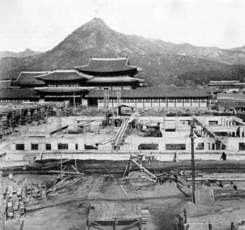
Archival photograph showing the construction of the Japanese General Government Building in front of Gyeongbok Palace.[7]

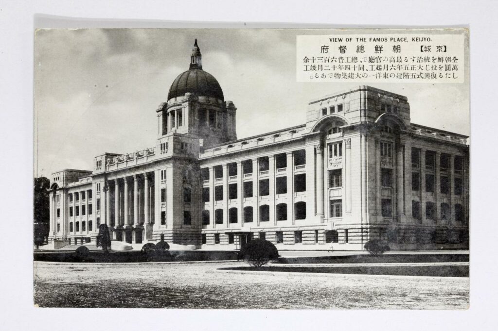
 The Japanese General Government Building in Seoul was built in 1926 by the Empire of Japan as the central administrative headquarters of their colonial rule over Korea. The building was constructed over the site of Gyeongbok Palace, widely renowned as one of Korea’s most auspicious and important cultural locations. Yoon explains how the Japanese used a method known as ‘palimpsest’ in order to naturalise their new colonial icons. This involves a deliberate comparison of a new “strong” icon against an old “weak” icon.[8] In the case of the Gyeongbok site, the Japanese did not completely replace the Palace with their own building.[9] Rather, they left part of the ruins in place to the back of their new building (an area which, according to geomantic interpretations, is unfavourable). The General Government Building towered over the Palace in both physical height and symbolic strength. This deliberate visual comparison of the two powers represented here had a clear interpretation: Japan was strong, Korea was weak.

Archival photograph of the former Japanese General Government building located in front of Gyeongbokgung Palace in central Seoul (source: Busan Museum).[10]

 The Japanese were said to have deliberately disrupted the geomancy of the Korean site in an attempt to legitimize their power and de-legitimize Korean nationalism. During the debate in the 1990s over whether the General Government Building should be demolished, there was a widespread public discourse that the building had been the leading weapon in a Japanese plot to deliberately block Korea’s national energy (as encapsulated in the Gyeongbok site).[11] This was proliferated by the discovery of “Japanese spikes” under the site of the building during the demolition process;

These spikes were 20 to 25 centimetres in diameter and 4 to 8 metres in height, and they were tightly packed, about 60 centimetres apart from each other. (Dong-a Newspaper, 29 November 1996).”[12]

A photographic example of similar Japanese spikes supposedly found by activists between 1995 and 2001 in the Jirisan National Park.[13]

The spikes were driven into the ground supposedly as part of the building’s foundations but, in the mind of the Korean public, they were a purposeful attempt to suppress the “earth-energy” of Joseon’s finest palace.[14] Without the nationalistic geomantic interpretation of what these spikes represented, their findings would have otherwise been of little note to the Korean public. Although, it is important to note that whilst the argument that the Japanese purposefully constructed their General Government building in order to destroy the geomancy of Gyeongbok palace is widely accepted, the argument that Imperial Japan deliberately fixed these iron spikes into the ground as part of this remains controversial.[15] 

Yoon argues that geomancy was not the cause of this battle over the Gyeongbok landscape.[16] Rather, the geomantic interpretations taken from the actions of these two powers (and the buildings represented by them) were used and manipulated in order to achieve various political aims, and to legitimize and de-legitimize support for Imperial Japan in the Korean public mindset throughout the 20th century.


[1] Yoon, Hong-Key, ‘Ch15 Iconographic Warfare and the Geomantic Landscape of Seoul’, in The Culture of Fengshui in Korea: An Exploration of East Asian Geomancy, Lexington Books (1988): p. 283

[2] Han, Jung-san, “Japan in the Public Culture of South Korea, 1945-2000s: The Making and Remaking of Colonial Sites and Memories,” Japan Focus, Vol. 12, Issue 15, No. 2 (2014)

[3] Yoon, Hong-Key, ‘Ch15 Iconographic Warfare and the Geomantic Landscape of Seoul’, in The Culture of Fengshui in Korea: An Exploration of East Asian Geomancy, Lexington Books (1988): p. 277

[4] Ibid, p. 287

[5] Ibid, p. 304

[6] Yoon, Hong-Key, ‘Ch14 The Social Construction of Kaesong,’ in The Culture of Fengshui in Korea: An Exploration of East Asian Geomancy, Lexington Books (1988): pp. 241-42

[7] Booth, Anne, ‘Did It Really Help to be a Japanese Colony? East Asian Economic Performance in Historical Perspective’, Japan Focus, Vol. 5, Issue 5 (2007)

[8] Yoon, Hong-Key, ‘Ch15 Iconographic Warfare and the Geomantic Landscape of Seoul’, in The Culture of Fengshui in Korea: An Exploration of East Asian Geomancy, Lexington Books (1988): p. 281

[9] Han, Jung-san, “Japan in the Public Culture of South Korea, 1945-2000s: The Making and Remaking of Colonial Sites and Memories,” Japan Focus, Vol. 12, Issue 15, No. 2 (2014)

[10] Park, Yuna, ‘Controversy over architectural heritage from Japanese colonial era continues,’ The Korea Herald (Aug 10, 2020) http://www.koreaherald.com/view.php?ud=20200819000642 [Accessed 23/10/21]

[11] Han, Jung-san, “Japan in the Public Culture of South Korea, 1945-2000s: The Making and Remaking of Colonial Sites and Memories,” Japan Focus, Vol. 12, Issue 15, No. 2 (2014)

[12] Ibid

[13] Personal photograph from ‘Did the Colonial Japanese drive Spikes into Sacred Korean Mountains…?’ http://www.san-shin.org/Spikes-controversy.html [Accessed 23/10/21]

[14] Han, Jung-san, “Japan in the Public Culture of South Korea, 1945-2000s: The Making and Remaking of Colonial Sites and Memories,” Japan Focus, Vol. 12, Issue 15, No. 2 (2014)

[15] Ibid

[16] Yoon, Hong-Key, ‘Ch15 Iconographic Warfare and the Geomantic Landscape of Seoul’, in The Culture of Fengshui in Korea: An Exploration of East Asian Geomancy, Lexington Books (1988): p. 304


Bibliography

  • Booth, Anne, ‘Did It Really Help to be a Japanese Colony? East Asian Economic Performance in Historical Perspective’, Japan Focus, Vol. 5, Issue 5 (2007)
  • Han, Jung-san, “Japan in the Public Culture of South Korea, 1945-2000s: The Making and Remaking of Colonial Sites and Memories,” Japan Focus, Vol. 12, Issue 15, No. 2 (2014)
  • Park, Yuna, ‘Controversy over architectural heritage from Japanese colonial era continues,’ The Korea Herald (Aug 10, 2020) http://www.koreaherald.com/view.php?ud=20200819000642 [Accessed 23/10/21]
  • Yoon, Hong-Key, ‘Ch14 The Social Construction of Kaesong,’ in The Culture of Fengshui in Korea: An Exploration of East Asian Geomancy, Lexington Books (1988)
  • Yoon, Hong-Key, ‘Ch15 Iconographic Warfare and the Geomantic Landscape of Seoul’, in The Culture of Fengshui in Korea: An Exploration of East Asian Geomancy, Lexington Books (1988)
  • ‘Did the Colonial Japanese drive Spikes into Sacred Korean Mountains…?’ http://www.san-shin.org/Spikes-controversy.html [Accessed 23/10/21]

Haw Par Villa’s Starving and Triple Buddhas: A Perplexing Diorama

Starving Buddha


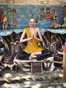
Having realized that I erroneously wrote two blog postings on secondary sources (because of how interesting the ideas that they offered were), I will do my penance and analyse a primary source that I gathered myself over the summer. The image in question is sourced from Haw Par Villa, one of the zaniest places in Singapore with the most cursed energy I have ever seen from a recreational space. The park itself was the pet project of the two brothers, Aw Boon Haw (胡文虎) and Aw Boon Par (胡文) that founded and ran a lucrative empire selling Tiger Balm, a medicinal salve that is still popular throughout Southeast Asia today.

Due to the sheer chaos that is the nature of this source, I am unsure as to whether it’s even possible to make a clear analytical point. One could discuss the synthesis of Daoist and Buddhist iconography in having Bodhisattvas, Buddhas, what I would assume to be Nezha and Dharmapalas (protectors of the Dharma) in the same image or even just the artistic choice of how these figures were depicted. As such, I have decided to focus purely on the significance of the Buddhas and Bodhisattvas depicted in the image.

The diorama appears to be attributed to the Lingshan Buddhist Group (霊山佛祖) based in Chaozhou (中国潮州). Further investigation showed that the place is indeed close to the city of Chaozhou, but is still a fair distance from it. Historical records of this particular Buddhist group are likely to be fairly scarce, and may have indicated that they paid for the particular diorama. Even the character for “Ling” is difficult to find and seems to either have been miswritten, or no longer exists in the current Chinese lexicon so much so that I was unable to input the exact character into my phone or computer.

The main figure depicted is an emaciated Buddha, a reference to the Gautama Buddha’s experience starving himself when he first left royal life. This form of voluntary starvation was seen as a form of ascetism and a symbol of how a person could gain ultimate control over their body (to the point of rejecting sustenance). The quite hilariously done, poorly-installed cord linking the larger statue to a smaller bowing figure in the background is a depiction of him achieving enlightenment (shown as ascendance) and meeting what I would assume to be the Buddhas of the Three Ages.

Typical descriptions of the Buddhas of the Three Ages would include Maitreya (representing the Future) and Gautama Buddha (who is notably absent in this depiction). The Prajnaparamita Sutra refers to the Buddhas of the Three ages in a single phrase (tryadhva-sarva-buddhāḥ) perhaps suggesting that the three are one reincarnated. It is without a doubt that the choice of these three specific Buddhas are deliberate and have enormous significance to story, but at a level that I cannot discern nor understand.

Maitreya is clearly depicted with his massive earlobes and belly, and Bodhisattva Guanyin with her classic hairstyle and vase. However, there is a Buddha that is difficult to discern based purely on appearance. The mysterious third Bodhisattva with a Ruyi (Chinese Sceptre). The plaques right above them is meant to clarify which Buddhas are being depicted, with Maitreya and Guanyin being fairly recognizable as “弥勒佛”and “观世音菩萨” respectively. The middle name, seemingly depicting the figure on the far right “世济佛菩萨” is mentioned in many Mahayana scriptures but is unknown to me.

The reasoning choice of Buddhas in this specific diorama may reflect which Buddhas the artists considered culturally important in this era. Or it may be an entirely arbitrary choice. Whichever it is, it certainly a fascinating and curious piece of historical Buddhist art.

Modernisation and Development in the Dutch East Indies

Pauline Roosemalen’s edited chapter on the Netherlands Indies Planning Commission provides a valuable insight into the notion of modernisation in relation to formal town planning in the Dutch East Indies. Roosemalen argues how Dutch initiatives to engage in formal town planning processes facilitated the modernisation of the colony for the Indonesian people in the early 20th century.[1] However, her argument falls upon an over-simplistic view of the nature of ‘modernisation’. Modernisation is viewed entirely within a Eurocentric and materialistic view, which filters Roosemalen’s view of Indonesian cities and kampongs. Dutch planned cities are viewed positively due to their material abundance and European style visual aesthetic, while native kampongs are viewed negatively because of their unplanned nature and ‘limited visual aesthetic’.[2]

I would contradict this argument by highlighting the limitations of Dutch town planning processes as agents of modernisation and the diversity of the Indonesian kampong. Kampongs are not monolithic, and neither is the modern Indonesian state. It encompasses a vast array of islands and resultingly cultures, languages and ethnicities. The diversity of the Indonesian kampong reflects the diversity of its people, a factor that Roosemalen does not present. Each kampong utilises a unique architectural style and town planning structure. Kampongs in Medan have houses with large, triangular, outward protruding grass roofs.[3] The extravagance and height of rooftop design increases depending on the importance of the building. Houses in Kampong Garut are one storey structures with tiled roofs and surrounded by large thatched windows to facilitate the free flow of air in and out of the structure.[4] Kampong Nias Selatan displays formal town planning elements as structures are arranged in rows adjacent to each other, with wide streets separating groups of residences. Next to these houses are large communal gathering centres with chairs arranged for outdoor recreation or discussion.[5] Even by European standards, kampongs displayed formal town planning and architectural design elements that provided necessary services for each community. Each kampong reflected its community’s social structure and its relationship to the landscape around them. They were not monolithic as Roosemalen might suggest and deserve further analysis as a distinct element of local town planning.

Additionally, Roosemalen argues a strong relationship between Dutch town planning and modernisation despite prevalent urbanisation issues that were evident even amongst the European population of its cities. In 1901, Surabaya came under high alert as the Shell Transport and Trading Company built petroleum reservoirs with weak foundations next to rivers that flowed into the harbour.[6] The reservoirs were at risk of breakage if filled too high, risking the entire Surubayan maritime industry and water reserves.[7] Even after the decentralisation policy and enactment of the town planning ordinance in 1903, the Singapore Rotary Club highlights pertaining issues of the Batavian urban landscape.[8] The article compares Singapore and Batavia with an apparent British bias towards its own colonial cities. However, the article does highlight important issues relating to formal town planning processes. By 1938, the city was organised with ‘little evidence of town-planning’ as buildings were placed abnormally distant from each other, overpopulation was rife, supply of basic necessities were limited, and traffic conditions were chaotic with no formal regulation in place.[9] Batavia is viewed as neither visually aesthetic nor materially abundant, two factors that enforced Roosemalen’s notion of Batavian modernness.

The formalised nature of town planning is what enforced Roosemalen’s argument of Dutch’ modernisation’. It exemplified the difference between the ‘modern’ Netherland Indies city and the ‘unmodern’ Indonesian Kampong. From the short analysis above, Dutch-planned cities appeared less formal and ‘modern’ as previously perceived. The analysis of urban planning appears to be both eurocentric and hypocritical as European urban landscapes did not even fit the parameters of modernisation set by Europeans. Although it is important to understand how institutionalised town planning affected the development of the Indonesian city, it is also vital to detach ourselves from a purely eurocentric view of ‘development and modernisation’ and engage with alternate understandings of town planning based on the political and environmental context of the landscape. 


Bibliography:

Primary Sources:

KITLV Leiden, ‘Kampong in Garoet’, photograph, 1910, Garut Indonesia, KITLV Leiden.

Lett, A, ‘Het dorpsplein van de kampong Sedregeasi op Zuid-Nias’, photograph, 1895, Nias Selatan Indonesia, Museum Volkenkunde.

‘Netherlands India’, The Straits Times, Singapore. June 24 1901, p. 3, <https://eresources.nlb.gov.sg/newspapers/Digitised/Page/straitstimes19010624-1.1.3?ST=1&AT=search&k=town%20planning%20ordinance%20batavia&QT=town,planning,ordinance,batavia&oref=article> [accessed 20th October 2021].

Onbekend, ‘Een kampong in Medan’, photograph, 1920, Medan Indonesia, Museum Volkenkunde.

Singapore Rotary Club, ‘Java and Malaya Compared’, The Morning Tribune, Singapore, 14th July 1938, p. 8, <https://eresources.nlb.gov.sg/newspapers/Digitised/Page/morningtribune19380714-1.1.8?ST=1&AT=search&k=(Town%20Planning)%20and%20(Batavia)&QT=town,planning,and,batavia&oref=article> [accessed 20th October 2021].

Secondary Source:

Roosemalen, Pauline, ‘Netherlands Indies Town Planning: An Agent for Modernisation’, in Freek Colombijn and Joost Cote (eds), Cars, Conduits and Kampongs: The Modernisation of the Indonesian City, 1920-1960 (Leiden, 2014), pp. 87-120.


[1] Pauline Roosemalen, ‘Netherlands Indies Town Planning: An Agent for Modernisation’, in Freek Colombijn and Joost Cote (eds), Cars, Conduits and Kampongs: The Modernisation of the Indonesian City, 1920-1960 (Leiden, 2014), pp. 87-90.

[2] Ibid., pp. 115-116.

[3] Onbekend, ‘Een kampong in Medan’, photograph, 1920, Medan Indonesia, Museum Volkenkunde.

[4] KITLV Leiden, ‘Kampong in Garoet’, photograph, 1910, Garut Indonesia, KITLV Leiden

[5] A Lett, ‘Het dorpsplein van de kampong Sedregeasi op Zuid-Nias’, photograph, 1895, Nias Selatan Indonesia, Museum Volkenkunde.

[6] ‘Netherlands India’, The Straits Times, Singapore. June 24 1901, p. 3, <https://eresources.nlb.gov.sg/newspapers/Digitised/Page/straitstimes19010624-1.1.3?ST=1&AT=search&k=town%20planning%20ordinance%20batavia&QT=town,planning,ordinance,batavia&oref=article> [accessed 20th October 2021].

[7] Ibid.

[8] Singapore Rotary Club, ‘Java and Malaya Compared’, The Morning Tribune, Singapore, 14th July 1938, p. 8, <https://eresources.nlb.gov.sg/newspapers/Digitised/Page/morningtribune19380714-1.1.8?ST=1&AT=search&k=(Town%20Planning)%20and%20(Batavia)&QT=town,planning,and,batavia&oref=article> [accessed 20th October 2021].

[9] Ibid.

France and Japan: Community versus Utopia

In the first half of the twentieth century, various parts of China were under colonial control. In the north, Japan controlled Manchuria from 1931 to 1945. In the south, Guangzhoudong was part of French Indochina from 1898 until it was taken over by the Japanese in 1943. In the early stages of either colony, French and Japanese officials employed different tactics in the colonial community building. This piece will compare Japanese and French efforts of community building in Manchuria and Guangzhoudong respectively.

In Japan, colonial city planning efforts prioritized Japanese prosperity. In order to do so, they planned to create an array of organized farming villages with the help of the Guangdong Army. According to David Tucker, in 1933 Japanese planners proposed to move over 100,000 farmers to fifty new villages in northern Manchuria.1 Tucker explains that Japanese planners saw Manchuria as a blank slate, perfect for the pursuit of utopian plans.2 The plan, as Tucker describes, consists of the creation of villages, each comprised of three hamlets whose goal was to sustain an economically and psychologically viable life for Japanese immigrant farmers.3 It is important to note that these hamlets were built in order to appeal to the everyday life of the Japanese. Tucker reveals that “the village plan portrays an entire plain as completely Japanese; one sees at first not even a sliver of Chinese space.”4 Japanese planners aimed to create a Japanese utopia; the lives of the Chinese immigrants were not recognized. In accordance, these villages were heavily militarized in order to keep the non-Japanese out. In Tucker’s words: “the plan accommodates two sets of very different activities, those of the Japanese settlers and those of the enemy it defends against.”5 With this in mind, Japanese planners’ goal in the creation of farming villages in Manchuria was to create a Japanese utopia. All plans revolved around the prosperity and military protection of the Japanese immigrant. On the other hand, French officials sought to create a community where colonials shared prosperity.

In 1902, Alfred Cunningham writes of his experience of French colonization efforts in Guangzhoudong. In a similar fashion to the Japanese hamlets and villages, Cunningham reveals that “French Administrators are assisted by a system of rural communes;” however, whereas the Japanese hamlets were under Japanese control, the communes in Guangzhoudong appointed a council of elders to collect taxes and decide where tax money should be allocated for infrastructure.6 Although Cunningham does not clearly say who these elders are and who appoints them, there are multiple distinctions between the French and the elders, implying that the elders are in fact Chinese. Moreover, the French military was not entirely French. In order to create a community space, Cunningham tells us that French officials employed a “garde indigene,” a local police force comprised of Chinese policemen.7 The greatest difference between the Japanese and the French was the French’s welcoming community building efforts. Cunningham says that in the French communes “everything was being prepared for the accommodation of the population, foreign and native, by a paternal government.”

In short, in France and Japan’s colonial city planning efforts in China, Japanese officials sought to create a Japanese utopia, built by and for the Japanese people, while French officials created a community which favored the prosperity of all.


Bibliography:

Cunningham, Alfred, The French in Tonkin and South China, (London, 1902)

Tucker, David, ‘2. City Planning without Cities: Order and Chaos in Utopian Manchukuo’ in Mariko Asano Tamanoi (ed), Crossed Histories, (Honolulu, 2005), pp. 53-81


  1. Tucker, David, ‘2. City Planning without Cities: Order and Chaos in Utopian Manchukuo’ in Mariko Asano Tamanoi (ed), Crossed Histories, (Honolulu, 2005), p. 53 []
  2. Tucker, ‘City Planning without Cities’, p. 55 []
  3. Tucker, ‘City Planning without Cities’, pp. 61-64 []
  4. Tucker, ‘City Planning without Cities’, p. 67 []
  5. Tucker, ‘City Planning without Cities’, p. 66 []
  6. Cunningham, Alfred, The French in Tonkin and South China, (London, 1902), pp.13-14 []
  7. Cunningham, The French in Tonkin and South China, p.14 []

Badly Drawn Maps

Badly Drawn Maps and what they can teach us

What makes a good historical map? Do detail and accuracy outweigh aesthetics and simplicity? Alternatively, what makes a bad historical map? Plenty of contemporary pop culture articles find entertainment in examining strange historical maps, assuming their scientific inaccuracy is something comical. But within these ‘inaccuracies,’ can we find historical insight we might have otherwise overlooked? This is the essential question Martin Bruckner seeks to answer. Don’t dismiss a historical map based on assumptions of what makes a ‘good’ or ‘bad’ map, argues Bruckner, rather we should explore why these definitions exist in the first place.

When examining maps, we make various assumptions about the relations of the map: the territory itself as existing independently of the map, north/south being top to bottom, east/west being right to left, and so on.[1] The “old” method of understanding historical maps, according to Bruckner, suggests that ‘good’ maps have unmistakable meanings, and ideals like truth and error are conceptually presented through them. They are the products of empirical science.[2] The map is a representation of a place. Yet, from the 1990s, ‘place’ began to be thought about more broadly, and scholars began treating maps as “subjective representations of social locations and human activities.”[3] This understanding also treats maps as places themselves.

In this view, maps are considered text-specific locales, or sites, shaped by a variety of contexts, ranging from the biography of the mapmaker to the geography of map production to the language of maps.”[4]

For Bruckner, however, our analytic approach to maps should go a step further than this text-based understanding. Historical maps are representations of places deeply endowed with sociality, being both man-made and “man-used.”[5] He argues for considering maps as products of social practice, shaped by all of the aspects that go into their creation; they are moulded by the engraver, painter, ink and paper suppliers just as much as the scholars and librarians who consume them.[6] Similarly, Matt Reeck views maps as “architecture of mind”. He argues they are a dynamic component of a historical process of commerce and settlement: “The advent of good maps is the advent of control over the land…”[7] For Reeck, mobility and movement of peoples is directly connected to cartography, and yet maps too often seek to standardize this; they aspire to “place places outside of time.”[8] Maps are social constructions, they push political agendas and represent societal attitudes. Their creation is often greatly influenced by power interests completely outside of the cartographic industry. Thus, can historical maps truly be deemed either ‘good’ or ‘bad’?


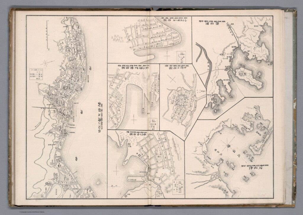
Taking Bruckner’s social approach, empirically ‘bad’ historical maps can now be considered useful and insightful in how they relate to issues other than physical geography. We can provide maps, seemingly objective creations, with historicity and time. Although developed in an American context, Bruckner’s approach can be equally applied to historical maps from East Asia. Examine this 1906 (Meiji 39) map by Japanese cartographer Yamane Akisato:


This atlas page shows 7 maps of various East Asian cities. Included (from left to right) are Hong Kong, Singapore, Vladivostok, Saigon, Bombay, Busan, and Wonsan. The maps show details of the city plan (roads, rivers, railways, etc.), the coastal outline, and major buildings, such as military stations. They are drawn in a simplistic black and white line drawing, which allows for a focus on the layout and structure of the cities and makes them easy to compare. These city maps were published in the atlas in between more detailed and coloured maps and illustrations, and the atlas includes text in both Japanese and Chinese. You may notice that these simple drawings are particularly ‘inaccurate’, or, in the very least, lacking detail. The coastline in the top-centre city (which I assume is meant to be Singapore, although it is difficult to tell) is comically simple, as if included in the compilation as an afterthought. In comparison, the coastlines of Busan and Wonsan on the right are drawn with more extreme detail. Deer Island in Busan’s Bay is especially noticeable, and details of smaller islands and water depth is even included. Although the map of Hong Kong (located far left) is denser, several of the streets are mislabelled in comparison to the reality of their positionality to one another. This strange picking-and-choosing of what details to include and what details to leave out by Akisato, the cartographer, is what makes this map so fascinating. If we now apply Bruckner’s social approach to analysing this map, it opens up the potential for historical interpretation and insight to be gained from it.


Drawn from the Japanese perspective in 1906 (Meiji 39), the map tells us how Japanese citizens might have seen and understood the world, and the importance of other cities in East Asia in comparison to their own. Placing these maps within the historical context of Japan’s activities in 1906, it makes sense for the map of Busan to detail so clearly the coastline and water depth around the city. Busan was a treaty-port which the Japanese held particular influence over around the time this map was published, and in which a strong Japanese presence had existed since the 15th century. Busan was the foothold through which Japanese forces established their control over the Korean peninsula prior to annexation in 1910.[9] It is likely Akisato may have visited Busan directly during his life, although not much is known about the cartographer himself and this is merely hypothetical. Regardless, as a Japanese citizen Akisato would have had, at the very least, more readily available access to information about Busan than to information about Singapore, for example, which was under British colonial control at the time.

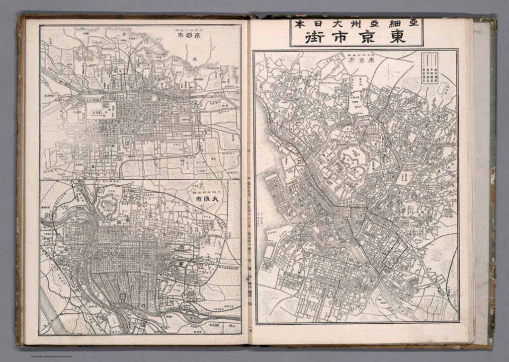
More acutely, these maps tell us how Akisato thought these cities should be presented in his atlas, and thus to those learning from his atlas. This highlights what he might have thought relevant, or in this case, not relevant, to be teaching other Japanese consumers about the wider world and about other cities across Asia, especially in comparison to Japan’s own major cities. There is a similar insert page in the same atlas that depicts Tokyo and its surrounding areas, Kyoto, and Osaka. These maps, meant to act as educational tools in the same way as the first 7 we examined above, are extremely dense, showing the grid block layouts of these cities in exact detail.


Considering the Japanese colonial context under which these maps were created once again, we can invoke Bruckner’s social approach to understand why these Japanese cities are presented more carefully. In the book How to Lie with Maps, Mark Monmonier argues that nations often enhance map features that support their point of view on the world and leave out details on the features that sit contrary to this.[10] Is this what is occurring here with Akisato’s atlas? Potentially, but further insight into this would require more research on his career and the publishing details of the atlas itself. At any rate, these maps are shaped deeply by Japanese colonialism and the power relations at play in East Asia in the early 1900s.

J. B. Harley maintains that historians of cartography often simply accept the cartographer’s suggestions of what historical maps are meant to represent, and advocates for greater scrutinization of maps as forms of knowledge creation. [11] The relationship between representation and reality contained within maps affects our relations to and perceptions of the material world, which is all the more pertinent considering a historical context far prior to the information technology era. These historical Japanese maps of various East Asian cities provide a good example of how we can scrutinize as Harley suggests, and they offer a great entry point for further research in this area.


[1] Searle, John. R., ‘Chapter 4: The Map and the Territory,’ in Wuppuluri, S. & Doria, F. A. (eds.) The Map and the Territory, Springer International Publishing (2018): p. 72

[2] Bruckner, Martin, ‘Good Maps, Bad Maps; or, How to Interpret A Map of Pennsylvania,’ Pennsylvania Legacies, Vol. 9, No. 2 (November 2009): p. 40

[3] Ibid, p. 40

[4] Ibid, p. 40

[5] Ibid, p. 40

[6] Ibid, p. 41

[7] Reeck, Matt, ‘A Brief History of the Colonial Map in India – or, the Map as Architecture of Mind,’ Conjunctions, No. 68, Inside Out: Architectures of Experience (2017): p. 185

[8] Ibid, p. 185

[9] Kang, Sungwoo, ‘Colonising the Port City Pusan in Korea: A Study of the Process of Japanese Domination in the Urban Space of Pusan During the Open-Port Period (1876-1910)’, Ph.D. Dissertation, University of Oxford (2012): p. 86

[10] Monmonier, Mark S., How to Lie with Maps, 3rd ed., Chicago: University of Chicago Press (2018): p. 132

[11] Harley, J. B., ‘Deconstructing the map,’ Passages, University of Michigan Library https://quod.lib.umich.edu/p/passages/4761530.0003.008/–deconstructing-the-map?rgn=main;view=fulltext [Accessed 09/10/21]


Primary Sources:

Akisato, Yamane, “Buson, Wonson, Vladivostok, Saigon, Bombay, Hong Kong.” from New Atlas & Geography Table (Bankoku chin chizu chiri tokeihyo), Nakamura: Shobido, Meiji 39 (1906) https://www.davidrumsey.com/luna/servlet/detail/RUMSEY~8~1~313791~90082699:Buson–Wonson–Vladivostok–Saigon-?sort=Pub_List_No_InitialSort&qvq=q:vladivostok;sort:Pub_List_No_InitialSort;lc:RUMSEY~8~1&mi=11&trs=12# [Accessed 08/10/21]

Akisato, Yamane, “Tokyo and environs, Kyoto, Osaka.” from New Atlas & Geography Table (Bankoku chin chizu chiri tokeihyo), Nakamura: Shobido, Meiji 39 (1906) https://www.davidrumsey.com/luna/servlet/detail/RUMSEY~8~1~313790~90082700:Tokyo-and-environs–Kyoto–Osaka?sort=Pub_List_No_InitialSort&qvq=q:author%3D%22Akisato%2C%20Yamane%22;sort:Pub_List_No_InitialSort;lc:RUMSEY~8~1&mi=21&trs=36 [Accessed 10/10/21]

Understandings of Fengshui amongst Protestant Missionaries

The first Europeans to come into contact with fengshui were missionaries who spread inland in the late 1840s and 50s as a result of the Opium Wars (Brunn, p.40.). The first record of Anglo-Dutch-German-American writing on fengshui was in the Chinese Repository Volume VI, published from May 1837-April 1838 by protestant missionaries working in China, intended to inform Europeans about life in China. For the next 13 volumes of the repository, fengshui was mentioned a few more times, either under the heading ‘geomancy’, or under from a linguistic/translation angle explaining the meaning of the word ‘fung’. Tracing the linguistic and cultural understandings of fengshui reveals that missionaries engaged linguistically with Chinese spiritualism, they made absolutely no progress over 15 years in understanding the practice of fengshui.

Wright explains that the underlying belief of fengshui is that the worlds of gods and men were interconnected, and that men needed to respect forces of nature and their ancestors, who played an important role in this interconnected web (Wright, p.41). That gods and men, living and dead were all interconnected and interacting is an important belief that protestant missionaries were attempting to understand in the Chinese Repository. In Vol. XVIII published in 1849, Philo explains the “Philological Diversions, illustrating the word Fung or Wind, in its various meanings and uses as they are exhibited by Chinese Lexicographers, Poets, Historians and the Common People” (Vol. XVIII, p.470). Philo provides the results of his “leisure reading in Chinese” with the hope that they will “entertain the readers of the Chinese Repository (Vol. XVIII, p.470). He expresses much personal delight at the “poetical and harmonical uses of this remarkable character”, and proceeds to discuss its multitudes of meaning, including ‘breath’, ‘spirit’ (Vol XVIII, p.473), ‘producer of all things’, ‘messenger of heaven and earth’ (Vol XVIII, p.474). While Philo’s account does seem to be a mere exploration through literature of the various meanings of this word, his article elicited a response in Volume XIX of the Chinese repository published the following year in 1850. W.H Medhurst Sen produced ‘Animadversions on the Philological Diversions of Philo’ (Vol. XIX, p.486), where he criticized Philo for his lack of accuracy in some of his translation. Medhurst states that ‘in Philo’s estimation, the Chinese regard Heaven and Earth “the Parents of all things”, as this controlling cause, and fung as one of their active agents in this grand operation’ (Vol.XIX, p.486), thus further interpreting the word’s meaning. The implications of these two discussions of the word ‘fung’, is that clearly attempts were made, even if just from a linguistic angle, at understanding the Chinese perspective of the world. What a linguistic analysis of a word could reveal about Chinese cultural perspectives was taken up with enthusiasm, and discussed by Protestant missionaries.

The same enthusiasm and attempt to understand a cultural perspective cannot be said about the practice of fengshui itself. In its first mention in Volume VI of the Chinese Repository, published 1837-8, fengshui is called a “vain superstition”, a belief that “buildings have an influence on all things around them”, that when “in a proper state of repair” they will cause “soil to be productive, the people prosperous, and the elements (such as fire, water, &c.) submissive and obedient” (Vol. VI, p.190). It is also remarked with disappointment that it is used by both commoners and distinguished men, and that the process of building a house or burial place takes months to make a decision on the precise place. The whole process is not treated with much sympathy from the writer, and rather as a silly idiosyncrasy, an ‘unaccountable Chinese superstition’, containing very little sense (Vol. VI, p.190). Nearly 15 years later, in Volume XX of the Chinese Repository published 1851, nothing has changed about the missionaries’ understandings of fengshui, but perhaps there is even more annoyance at the existence of the practice. This time, fengshui is discussed in is titled “Prohibitions addressed to the Chinese converts of the Romish faith, translated by P.P Thoms, with notes illustrating the customs of the country” (Vol XX, p.85). Specifically, “those who cause to be engraved on the tomb-stones, that such a hill was selected; and that the person lies towards such a point of the compass, and was buried on such a propitious day, or foolishly believe the geomancy of the fung-shwui- Sin” (Vol XX, p.90). After describing the practice of fengshui as a sin, the writer calls it ‘useless’ and ‘absurd’, and that it is only the ‘minds of the simple’, who could believe it. There is a tone of complete refusal to understand why a family would go through so much trouble to find a grave, after the geomancer will “pass over the same ground twenty times over” (Vol XX, p.90). As Brenda Yeoh argues, it was simply not understandable to Western minds why burial practices were so important for the Chinese, and so they were simply labeled as a sin, and as a foolish practice for their fellow missionaries to dismiss (Yeoh, p.288).

Comparing these four passages reveals that while linguistically missionaries were eager to engage with and debate understandings and uses of the word ‘fung’, to understand how the Chinese viewed the world, they were utterly unwilling to use that same knowledge of Chinese world viewpoint to understand the practice of fengshui. It is almost surprising, that over 15 years no deeper attempts were made to understand this clearly important practice, and that fengshui was described in both entries in fairly similar terms, with the same type of annoyance. This shows that the understanding of the worldview, and the practice itself were two separated things in the Western mind, and that while one was treated as a stimulating intellectual exercise, meant to delight Western readers, the other was treated as a non-acceptance of Christianity, a sin, and a fault to be righted by the protestants.


Primary Sources

Bridgemen, James Granger (ed.), Chinese Repository Volume VI, (Canton, 1838).

Williams, Samuel Wells (ed.), Chinese Repository Volume XVIII, (Canton, 1849).

Williams, Samuel Wells (ed.), Chinese Repository Volume XIX, (Canton, 1850).

Williams, Samuel Wells (ed.), Chinese Repository Volume XX, (Canton, 1851).


Secondary Sources:

Bruun, Ole, An Introduction to Fengshui (Cambridge University Press, 2008).

Wright, Arthur, ‘The Cosmology of the Chinese City’ in G. William Skinner ed. The City in Late Imperial China (1977).

Yeoh, Brenda, Contesting Space in Colonial Singapore (NUS Press, 2003), pp.281-311.

Fengshui’s Conception of Space: The Material and Metaphysical Divide in Practice

A thought that has been brewing in my head since MO3354 (East Asian Intellectual History) was the nature of the Ontic/Epistemic divide in Eastern Philosophies. In my limited study of Buddhism, I believe that they can bridge this gap through the concept of Enlightenment (barring the Yogachara School). This divide is even more difficult to understand in the context of the Yi Ching and Fengshui. As Feuchtwang describes it, “Fengshui offers plausible hypothesis, but never proofs”. [1] It is possible that practitioners of Fengshui aren’t concerned with the epistemology of their craft, much less the ontic/epistemic divide. To look at Fengshui under this split draw away from the issues that scholars of the Yi Ching and Fengshui deem important. To consider the ontic/epistemic divide in Fengshui is not necessarily important, rather we should look at the material/metaphysical divide that is more evident in ancient and modern debates in different schools of Fengshui.

The most obvious split between more materialist and metaphysical perspectives on Fengshui is between the School of Forms and Orientations. The School of Forms emphasizes concrete topological features and draws an interpretation from material phenomena to decide whether a place has good Fengshui or not. The School of Directions is much more complicated and encompasses cosmological aspects including the Five Elements, Numerology based on the Bāgùa, and even planetary alignments. [2] What we can see here is a clear split between how Fengshui is conceptualized. The School of Forms sees Fengshui in a materialistic light, where the School of Orientations looks at it in a more metaphysical sense. This divide between emphasis on the material and metaphysical has interesting implications on the practical applications of Fengshui on spaces. There appear to be fewer examples of specific modern practices based on the School of Forms compared to Orientations. This is likely due to the intrinsic adaptability of each School’s basic principles.

In terms of application, the materialist leaning of the School of Forms has lent itself well to larger-scale planning and in areas where space is abundant. For instance, Ming Dynasty Beijing’s city planning seems to follow principles from the School of Forms. With their dragon-shaped city planning and the artificial hill behind the Forbidden City. The central line of the city forms a giant winding dragon from north to south, with two large gates as its eyes. [3] We also see the rules in the School of Forms being especially strictly adhered to in burial practices, particularly in places such as Taiwan; where space constraints are less severe and topological features abundant. Entire south-facing hillsides in areas north of Taipei are dotted with mausoleums and horseshoe-shaped graves. Based on these examples, it is evident that the School of Forms and subsequent schools that follow a materialist interpretation of Fengshui are more suited towards the planning of larger areas, incorporating and using topology on a larger scale.

On the other hand, the School of Orientations with its various modern interpretations such as the Bāgùa and Flying Star Schools has found itself being applied much more generously in places such as an office or household context. The Flying Star School, with its heavier focus on numerology, can be adapted towards floor planning. With favourable number combinations used for bedrooms and offices, and less favourable combinations for less important spaces. [4] There are also examples of small Bāgùa panels with a mirror in the centre being hung above main doors. In the Chinese diaspora of Singapore and Hong Kong, household Fengshui seems to be informed by general practices in the School of Orientation, especially in the placement and direction of furniture; especially beds. The emphasis on the metaphysical rather than the material meant that the School of Orientations’ practices were much better suited to modern adaptations and interpretations.

Thus, the divide in the School of Forms and Orientations has resulted in varied applications of Fengshui in spaces. With practices from the School of Orientations and its derivatives dominating modern approaches to Fengshui. It would be interesting to read further into Fengshui practices and the Yi Ching. Especially, to determine which Schools and their derivatives have been propagated more widely.

[1] Ole Brunn, An Introduction to Fengshui (2008), p. 90

[2] Ibid, p. 151

[3] Madeleine YueDong and Reginald E. Zelnik, Republican Beijing: The City and its Histories, (2003), p. 8

[4] Ole Brunn, An Introduction to Fengshui (2008), p. 52

China Political Reports: British perspective on Sino-Japanese relations

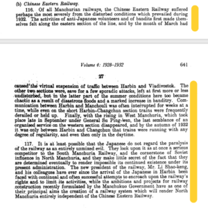
It is interesting to look into the China Political Reports from the years of the Japanese establishment of Manchukuo, not only to provide an outsider’s perspective into Sino-Japanese relations, but also to analyse how the railway was used as a non-military method of control, and how railways were used by the British to interpret the often secret negotiations between China and Japan. The extracts analysed are taken from China Political reports from two volumes: Volume 4, containing reports written between 1928-32, and Volume 5 written between 1933-36. These were confidential documents, written by two British diplomats as part of the annual reports on China, for use of the foreign office. The first extract is from the 1932, the year Japan established Manchukuo, discussing the year’s impact on the Chinese Eastern Railway. It was telegrammed to Sir John Simon in Britain from Mr. Ingram, a British consul in China. The source describes how the Chinese Eastern Railway suffered the most during these years because of anti-Japanese sentiments, bandits along the eastern sections of the line, and floods, which resulted in the suspension of traffic between Harbin and Vladivostok, two major Russian railway towns. Meanwhile, the Southern Manchurian Railway (SMR) “borrowed and surpassed” Russia’s railway plans and insisted that the SMR’s facilities were the most modern available (Buck, 75). This leads to Mr. Ingram’s hypothesis that “it is at least possible that the Japanese do not regard the paralysis of the [Chinese Eastern Railway] as an entirely unmixed evil”- it is the main competitor of the SMR as well as the “cornerstone of Russian influence in North Manchuria”. The implications of this are that with the Chinese Eastern Railway weakened; the Japanese could continue exerting their influence in Manchukuo. If, as Buck frames it, Changchun represented the “inland extension of a foreign-dominated treaty port”, then the railways were the key to exerting control in a place without direct outright military action (Buck, 65). The Japanese gained control first through the railway, and then through the establishment of a government of Manchukuo.


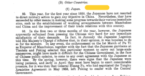
The next set of extracts is from Sir Alexander Cadogan to Sir John Simon as part of the annual report on China in 1934, two years following the establishment of Manchukuo. 1934 also marked the first year since 1930 that “the Japanese have not resorted to direct military action to gain any objective in China” (p.278). Cadogan then goes on to speculate that because it would be a blow to Chinese public opinion to have any outright agreements with Japan, the two countries have been conducting their affairs “gradually and without any publicity” (p.270). Many of Cadogan’s interpretations are based on analysis of the railway traffic going between Manchukuo and China: it is in this way that China was able to negotiate a relationship with Japan without needing to publicly recognise the government of Manchukuo. The railway and the towns attached to them become important levers in establishing a peaceful relationship between the two countries.


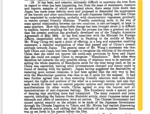
A further report on the “subsequent developments in the general political situation between China and Japan” (p.331) were provided by Cadogan again on May 17, 1935. He states, with hints of personal annoyance, that it is “difficult to ascertain the true facts in regards to what has been happening” (p.336) between China and Japan, and that China was acting “with characteristic vagueness” (p.336) to meet Japanese demands and restore normal friendly relations. Cadogan’s annoyance here is probably indicative of the increased secrecy of negotiations between China and Japan, and an increased reliance on railways, infrastructure, and other elements of modernisation to protect Japan and China from Western aggression (245, Louise Young). Young argues that the railway exemplified just one method of building modernity within Japan and its empire, without needing any assistance from the West. Cadogan goes on to describe the “long and somewhat rambling statement” of the Minister of Foreign Affairs Wang Ching-wei, stating that both China and Japan have seemingly set aside the question of Manchukuo. Meanwhile, Japan was determined to increase the Japanese population in Manchuria while planning a highly ambitious development programme for their new territory, including the development of the railway, highways, air transport and communications networks (Tucker, 53). Japan would continue exerting control over Manchukuo through its commercial drive: by the end of 1936 there were countless Japanese shops, restaurants, hotels and other small businesses in railway towns throughout Manchuria (Young, 254). This is evidence that Japan was continuously asserting its dominance in Manchukuo, and that China was appeasing these demands, without the need for overt military force from either side. So, it is through no coincidence that these foreign reports on Sino-Japanese relations rely on railways and other commercial agreements to speculate on what diplomatic agreements were being reached by both countries- they often reveal more than official military or diplomatic discussions.


Bibliography:


‘Mr. Ingram to Sir John Simon: Annual Report, 1932’, in Robert L. Jarman (ed.), China Political Reports 1911-1960, Vol. 4 (Chippenham, 2001), pp.640-1.


‘Sir A. Cadogan to Sir John Simon: Annual Report 1934’, in Robert L. Jarman (ed.), China Political Reports 1911-1960, Vol. 5 (Chippenham, 2001), pp.269-336.


Buck, David D. “Railway City and National Capital: Two Faces of the Modern in Changchun” in Railway City and National Capital: Two Faces of the Modern in Changchun, pp.65-89.


Tucker, David “City Planning Without Cities: Order and Chaos in Utopian Manchukuo” in Mariko Asano Tamanoi ed., Crossed Histories: Manchuria in the Age of Empire, pp.53-81.


Young, Louise, Japan’s Total Empire: Manchuria and the Culture of Wartime Imperialism, Twentieth-Century Japan (Berkeley, Calif: University of California Press, 1999), “Brave New Empire: Utopian Vision and the Intelligentsia” pp.241-268.