Quantifying Our Home: Content study of an Urban Mass Housing Magazine

This blog explores findings from a quantitative analysis of the contents of HDB Our Home Magazine. Specifically, the first issue (October 1972), an issue in its 5th year (October, 1977), an issue in its 10th year (October, 1982), and its final issue (Aug-Sep, 1989).  ‘Our Home’ was a magazine run by the Housing and Development Board (HDB) in Singapore from 1972-1989, free to its residents (and 50 cents to non-residents) it provided articles and advice on cooking, housing and cultural topics. This study looked at the quantity and genre of different types of content in the magazine issue. Due to language limitations, only the English content is included here. Overall, the results suggest that while there was a surprising lack of dialogue between advertisements and articles; while the advertisements pushed the narrative of modernity and domesticity through products and services related to modern interior design and new technology, the editors of the magazines were far more concerned with highlighting the harmonious, diverse community of HDB.

Definitions:

Contributions – Content that included contributions from the community (e.g. Q&A, recipes, opinions)

Notice & Housekeeping – Content that is presented as important information to residents (e.g rent info, maintenance, housing reminders)

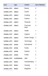
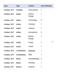
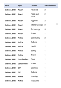
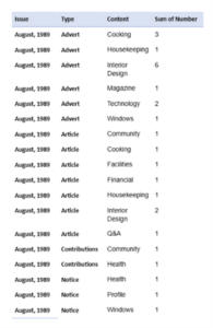
Fig. 1-4 Breakdown of the spread of different types and content topics in each of the 4 magazine issues respectively

While this is a limited data sample, spaced at appropriate intervals over the magazine’s run, some insights can be gleamed. Advertisements are the category to display the most changes over the 4 issues, beginning with 10 different advert genres initially, then having an unusual year in 1977 with only 2 genres and 6 adverts in total, before stabilising at 6 different types for the next two issues. While this likely fluctuates in issues beyond the data set, I think the high number in the first issue is likely a reflection of the investors and the advertorial team not knowing what the magazine’s readership or purpose was yet. This uncertainty is present with both the adverts and articles in the featuring beauty and fashion in the first issue and abandoning them in the subsequent issues. Potentially, they realised they had broader appeal than just women, or perhaps the editorial team decided they wanted to mould the home, not the housewife. Either way, it’s clear they moved away from being a women’s magazine to being a home magazine. In terms of content the articles started to lean more consistently towards community and instructional guidance, while adverts focused on interior design and technology as their primary promotional content.


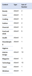
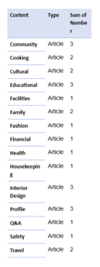
Fig. 5-6 Culminative number of different content type in advertisements and articles across the 3 magazine issues.

The breakdown of the technology adverts largely consisted of sound technology, cooking machinery and Sony products. The interior design adverts ranged from furniture salesrooms, tilers, and kitchen upgraders. While it would be tempting to use this to draw a parallel between HDB’s approach to technology and the modern home to what Tatiana Knoroz describes as an obsessive drive to keep technologically up-to-date in Japan’s mass housing of Danchi to justify its value as middle class housing, this magazine doesn’t support this link (1). While this may be the narrative of the adverts, none of these issues have an article about technology. Even in the 3 interior design article there is no push towards modern interior design, indeed in one of them compares a modern and traditional home interior and concludes they are both equally ‘cosy’ (2). Their focus is more on building community relations through profiles on people and communities, advice on living in HDB residences, and instructional articles. This is reflected in the 3 languages that the magazine is presented in. Another technique they are keen to push is community contribution to the magazine, in the contents page of the four issues, but contribution consistently remains low in this data set, perhaps indicating a lack of engagement or desire for this type of interaction.

Ultimately then, while this small quantitative study seems to mirror some narratives of modernity’s effect on post-war mass housing, the articles’ themselves don’t seem to mirror the same drive to modernise and westernise interiors and equipment. While adverts are a part of the magazine’s value system and narrative, the lack of dialogue between them in this data bears some highlighting.

Footnotes

  • Tatiana Knoroz, Dissecting the Danchi: Inside Japan’s Largest Postwar Housing Experiment. (Springer Nature, 2022), pp. 41-112
  • ‘Vast Variations’, Our Home (Singapore, House and Development Board) August-Sep, 1989, p.28

Reference list:

Our Home (Singapore, House and Development Board), October, 1972

Our Home (Singapore, House and Development Board), October, 1977

Our Home (Singapore, House and Development Board), October, 1982

Our Home (Singapore, House and Development Board), Aug-Sep, 1989


The bedroom of Hock Gwee Thian’s house in Singapore: Inside an intricately designed Peranakan home

A unique and vibrant culture has taken root in the bustling streets of Singapore, whose members are known as Peranakans. The term ‘peranakan’ originates from the Malay word ‘anak,’ meaning child and has come to signify being locally born.1 Yet it crucial to mention the freighted task of defining the term ‘peranakan,’ for their shifting political and cultural dynamics that have come to characterise this community has led to a rich and multifaceted history. In fact, in Southeast Asia there are Peranakan Indians who are Hindu and called Chitty Melaka, as well as Peranakan Indian Muslims called Jawi Pekan, in addition to Eurasian Peranakans and Peranakan Chinese, to name a few.

However, this discussion will focus on the Chinese Peranakans in Singapore. The history of the Chinese Peranakans in Singapore traces back to the arrival of traders from the southern province of China, who settled in the Malay Archipelago. Not only did they establish a trade network, but they married local Malay women. This intermarriage gave rise to a unique blend of cultural practices, traditions and languages.2 After Sir Stamford Raffles signed a treaty in 1834 which led to the establishment of trading posts in Singapore, these traders migrated to Singapore and left an indelible mark on its architectural landscape. The shophouses, bungalows, and mansions they established in Singapore reflected the rich tapestry of cultures and traditions in which the Peranakan Chinese community engaged with throughout their history.3

Indeed, one way to explore the rich history of the Chinese Peranakan community is by taking a closer look at their homes, which also helps reflect a relationship between identity, space and architecture. The Peranakan home is a tangible symbol of the cultural fusion that defines Singapore. These homes are often built with a blend of Chinese, Malay and European architectural influences, which reflect the multicultural fabric of Singapore and the peaceful coexistence of various ethnic and cultural groups. However, there is no architectural style that can be exclusively attributed to the Peranakan Chinese, like the Peranakan people themselves, housing developed with an array of variations each reflecting a specific place, time and economic circumstance in which it was created. Therefore, this discussion will look at the memoir of William Gwee Thian Hock’s whose narration provides an illustration on how identity was forged in their living space. Yet, as one steps into the world of the Peranakan home, it is a complicated space, thus this discussion will also focus solely on the bedroom as an example of how space and identity were harmoniously woven together.


Figure 1. An extraordinary presentation of a bridal suite in a Peranakan home.4

William Gween Thian Hock’s memoir, A Nyonya Mosaic, is set in Singapore in 1910 and narrates the childhood of his Nyonya mother through her own eyes. Throughout there are scenes of happy celebrations, as well as disease and death. Hock’s scenes of a wedding are particularly intricate and colourful, and does well to shed life on the lived experiences in these homes. Moreover, figure 1 helps capture the narrative in Hock’s memoir by presenting a reconstructed Chinese Peranakan bedroom, arranged to recreate the ambiance of a wedding day for the bride and groom. Together, these two sources illustrate a contact zone where a diverse array of cultures intersect and interact.

As stated in Hock’s memoir, ‘the bridal room was on of the focal points’ and as figure 1 illustrates significant preparation and thought had gone into its spatial layout.5. Figure 1 is a striking statement to the intricate beauty that characterises a Chinese Peranakan bedroom. Within this frame, one can witness a unique cultural fusion of Chinese, Malay and European traditions blending together to create a functional space. For example, the two canopy beds display European influence, whereas its ornate carvings are quintessentially Chinese.

Hock notes ‘I was rather taken aback when few days before [the wedding] I discovered that the beautifully carved wooden ranjang loskan would bot be used for the wedding. I have always associated this bed with weddings and there were even people who knew it by the name of ranjang kahwen (wedding bed). It seemed that it was no longer fashionable to use this ornate bed, and in its place, a Victorian four-poster brass bed had been chosen … the embroidered curtain around it, the embroidered bedsheet, the embroidered pillowcases and all thh other trimmings that festooned the bed had transformed it into a most charming wedding bed.’6

Indeed, in figure 1 on closer inspection ornate wood carvings are present and are quintessentially Chinese. For example, one can locate auspicious motifs such as dragons, phoenixes, magpies and mandarin ducks which signify harmony between the marrying couple. Furthermore, another interesting aspect of this bridal suite is the carpet. These rich tapestry-like carpets are referred to as ‘Irish carpets,’ which were produced in factories owned by Scottish textile manufactures in Ireland. They are made of velvet and have a smooth finish with saturated colours. The colours are exuberant, replicating the hues of tropical flowers that are important to Chinese culture.7 This spatial arrangement highlights their diverse identity.

It is interesting to note Hock’s statement that, ‘it seems so unfortunate that a wedding so oriental in flavour should suddenly find a western touch in it just for the pride of being “modernised”‘8 Hock’s statement reflects the disappointment felt in witnessing the groom’s attire change to a western-style lounge suit. But as stated in Elizabeth LaCouture’s influential work Dwelling in the World: Family, House and Home in Tianjin China, 1860-1960, this was a symbol of modernity. For individuals living in a Chinese urban home ‘modernity was not defined through Western and Chinese temporalities and cultures. To be modern meant to be comfortable dwelling in both of these worlds.’9 This perspective is crucial as it shows how such a community navigated their identities in a changing world. Clearly, they drew from their cultural heritage while incorporating aspects of Western culture, not as a contradiction, but as a means of adapting to the complexities of modern, cosmopolitan life.

This brief exploration of a traditional Peranakan wedding and the Peranakan bedroom effectively highlights how this community accepted, adopted and assimilated diverse cultures to form a cosmopolitan community of their own, based on their understanding of the world and conceptions of the modern.

  1. David HJ Neo, Sheau-Shi Ngo, Jenny Gek Koon Heng, ‘Popular imaginary and cultural constructions of the Nonya in Peranakan Chinese culture of the Straits Settlements,’ Ethnicities, 20:1 (2020), p.25. []
  2. Patricia Ann Hardwick, ‘”Neither Fish nor Fowl”: Constructing Peranakan Identity in Colonial and Post-colonial Singapore,’ Folklore Forum, 38:1 (2008), p. 37. []
  3. Roland G., Knapp, Peranakan Chinese home: Art and culture in daily life (2017), p.6. []
  4. Figure 1, ‘Image of a reconstructed Peranakan bridal suite,’ in Roland G., Knapp, Peranakan Chinese home: Art and culture in daily life (2017), p.142. []
  5. William Gwee Thian Hock, A Nyonya Mosaic: Memoirs of a Peranakan Childhood, (2013), p. 76. []
  6.   Hock, A Nyonya Mosaic, p. 78. []
  7. Knapp, Peranakan Chinese home, p.144.  []
  8. Hock, A Nyonya Mosaic, p. 104. []
  9. Elizabeth LaCouture, Dwelling in the World: Family, House and Home in Tianjin China, 1860-1960, (New York, 2021), p. 153. []

Building on Tradition: From Kampong to High-Rise, the ‘tropical city’ and its manifestation in Singapore

The elusive topic of tropicality has pervaded conversations surrounding the design and function of Singaporean architecture since the imposition of Western architectural styles and layouts following the ratification of the Treaty of Singapore in 1819. This article will argue that the categorisation of Singapore as a ‘tropical city’ comprised of ‘tropical architecture’ is the product of colonial power that was integrated into the production of knowledge about the built environment and is therefore inherently responsible for the continuation of discourses that associate Southeast East cities as the ‘other’ to those in Western, temperate climates.1 However, as architects like Mr Tay Kheng Soon illustrate the term ‘tropical city’ has also served as a reclamation of Singaporean independence and the celebration of the city’s culture and agency through a selective incorporation of European modernity.2 This article analyses a Straits Times interview conducted in 1989 by Patrick Daniel and Caroline Chan of the Singaporean architect Mr Tay Kheng Soon who applied his vision of the tropical city to Singapore to detach the independent city-state from the epistemic conquest of British hegemony.3

Figure 1: Article in The Straits Times, “Concept for future city: Living in a work of art”.4

Tay envisioned an “intelligent tropical city” and argued that a tropical city could emancipate Singaporeans from the economic dominance of Britain in the region.5 He aimed to re-politicise urban planning by separating the city from the “mono-cultural compactness” of colonial offices and housing by designing Singapore to be a “work of art” and a compact city capable of “increasing business opportunities” and “providing a medium for intense, social, cultural and economic exchange.6 By using the tropical city concept, Tay identifies that the architectural aesthetics of tropicality were attached to colonial and post-colonial power relations and seeks to separate Singapore from these streams of power. By designing a city which prioritises “poly-cultural compactness”  to form a  “support structure for their [people’s] activities… and yet contribute to the cooling of the city as a whole” he illustrated that colonial power was ingrained in the construction of Tropicality. Equally, he highlights that Signporean architects had the necessary tools to begin deconstructing this discourse.7

The introduction of ‘tropical architecture’ established a sphere of knowledge which ran through Imperial networks during the colonisation of Singapore and was utilised by the Colonial Office to ‘other’ Southeast Asian architecture in opposition to temperate architecture.8 The term tropical architecture prioritises the climate in its terminology whereas temperate architecture is categorised by regional geographic zones or nations, imposing a homogenous staticity onto Singaporean urban development.9 Tropicalisation involved the surface-level modification of Western governmentalities to tropical conditions rather than the necessary transformation.10 Tay emphasises that in the 1980s tropicality was not considered “another symbol of modernity” and he asserted that the “big bland blocks” of highrises that covered the city were “still a sign of the captive mind”.11 Indeed, the “captive mind” he refers to in the Straits Times interview illustrates the power-knowledge concept and the overt control colonial powers had over conceptions of tropical architecture and their subsequent limitation of the built environment to benefit colonial wealth and power.12  The perpetuation of this reductive understanding of the city’s needs justified the colonial administration’s choice to prioritise Singapore’s sanitation and fears of reassuring contamination issues, rather than holistically solving civic issues through the optimisation of the built environment.13

Tay’s Straits Times interview and his successive proposals for tropical urbanism began to combat the circulation of British colonial networks and their epistemic conquest over the focal point of Singapore’s housing strategies by proposing socio-economic structural problems were addressed which would in turn resolve sanitation issues.14 By proposing that the tropical city is defined by its interconnectedness, Tay defined the tropical city by its, “combination of tropical rain forest with the city by increasing transpiration”.15 To establish Singaporean independence from colonial power relations Tay designed a climate-responsive built environment, working in favour of its citizens.16 His holistic approach to the city and its economy assimilated tropical architecture into the tropical climate rather than adopting temperate architectural models that exacerbate the urban heat island effect.17 As Chang explains, the architectural aesthetics of tropicality are inseparably bound to colonial and postcolonial power relations and the implementation of Western hegemony through ideals of social order and the application of policy.18 These concepts are closely linked to the sanitisation movement and the colonial government’s preoccupation with contamination, these fears greatly influenced the structure and organisation of Singapore’s housing and the developments that occurred beyond the European socio-spatial enclaves of the city.19

Tay’s reclamation of the term ‘tropical city’ reflects the complex relationship between language and the built environment in Singapore’s postcolonial legacy. Alongside other regional architects, Tay produced a deviating discourse on tropical architecture that challenged the cultural and economic supremacy of the West by proposing a multi-tiered city. By prioritising the city’s functionality, his urban planning methods and vision were ahead of their time and later were used to distinguish Singaporean identity as heterogonous and separate from Western notions of tropicality.

  1. Chang Jiat-Hwee, A Geneology of Tropical Architecture: Colonial Networks, Nature and Technoscience (New York, 2016), p.7. []
  2. Chang, A Geneology of Tropical Architecture, p.1. []
  3. Chang Jiat-Hwee, “Deviating Discourse: Tay Keng Soon and the Architecture of Postcolonial Development in Tropical Asia”, The Journal of Architectural Education, 63:2 (2010): 153. []
  4.  Kheng Soon Tay, “Concept for the future city: Living in a work of art”, The Straits Times, Singapore, 8th May 1989, p.16 Accessed at: https://eresources.nlb.gov.sg/newspapers/digitised/article/straitstimes19890508-1.2.49.2 (Accessed 24/10/2023) []
  5.  Kheng Soon, “Concept for the future city: Living in a work of art”. []
  6. Ibid. []
  7. Ibid. []
  8. Chang, A Geneology of Tropical Architecture, p.5 []
  9. Ibid, p.6 []
  10. Chang Jiat-Kwee, “Tropicalizing Planning, Sanitation, Housing and Technologies of Improvement in Colonial Singapore, 1907-1942”, in Robert Pecham and David Pomfret (eds.) Imperial Contagions: Medicine, Hygiene and Cultures of Planning in Asia, ( Hong Kong, 2013), p.41. []
  11. Kheng Soon, “Concept for the future city: living in a work of art”.  []
  12. Chang, A Geneology of Tropical Architecture, p.6. []
  13. Chang, “Tropicalizing Planning, Sanitation, Housing and Technologies”, p.37. []
  14. Chang, “Deviating Discourse”: 154. []
  15. Kheng Soon, “Concept for the future city: living in a work of art”. []
  16. Ibid. []
  17. Chang, “Deviating Discourse”: 157. []
  18. Chang, A Geneology of Tropical Architecture, p.2. []
  19. Chang, “Tropicalizing Planning, Sanitation, Housing and Technologies”, p.38. []

Memorial Modifications: Singapore’s Changi Prison Through the Framework of “Corrective Remembering”.

“To achieve a genuinely shared memory, rather than a common memory made up of assorted aggregates, communication is essential for opening up the process of remembering to a multitude of voices, instead of indoctrination”.[1]

In their monograph, Heritage, Memory, and Punishment: Remembering Colonial Prisons in East Asia, Shu-Mei Huang and Hyun Kyung Lee introduce the concept of “corrective remembering” to uncover the motivations and implications of post-colonial prison museum developments in East Asia.[2] The idea of correction is seen by the two authors as an attempt to modify, forget, or reimagine experiences of colonial incarceration in order to fit a political or ideological post-war narrative. For example, the heritagisation of Seodaemun Prison and its Independence Park formed part of a narrative of Korean victory and independence against Japanese. The authors argue that this rigid narrative was applied at the expense of other aspects of Seodaemun’s heritage, such as the Okbaraji neighbourhood, which was abandoned and demolished.[3] The concept of “corrective remembering” is chosen by the authors for three reasons, which they clearly reveal. Firstly, it pays tribute to the corrective form of punishment deployed in the prisons. Secondly, it aims to reveal the alterations made to the memory of the prisons when they were converted into museum pieces. Finally, the notion of correction can be used to describe the heritagisation of prisons which involves the removal and displacement of former structures and residents, where the “logic of punishment is reactivated” as part of a post-colonial ideology.[4] These three definitions of “corrective remembering” are valuable for an understanding of the construction of heritage in post-colonial states, where layers of obscurity and reimagination conceal the real force of collective memory.

These three definitions of “corrective remembering” can be applied to the case of Singapore’s Changi Prison and Chapel. The prison complex was constructed in 1933 but was converted into a prisoner of war (POW) camp at the start of the Japanese occupation of 1942. After the war, the prison was used by the British for the internment and execution of Japanese generals and prison officers.[5]

The reconstruction of the prison and its chapel into a museum was charted in the Straits Times Newspaper in 1987.[6] In this report, the memory of the chapel is described as a place of “spiritual solace and temporary refuge from the havoc of war”. This peaceful depiction contrasts with the reports of the Malaya Tribune from 1946, which describes the reality of the environment that Japanese POWs had to endure.[7] Within proximity to the church, prisoners lived in “specially erected gallows” where they “languished”, awaiting execution. The contrast in the reports exemplifies both the “corrective” aspect of POW punishment and the “corrective” remembering of the event. In modern memory, the church becomes the focal point of the Changi Prison complex as the newspaper description imprints an imaginative vision of peace which separates the environment of the prison from the realities of war. By contrast, contemporary reports suggest that the “havoc of war” still invaded the physical compound of the prison. The detained were subject to corrective policies of confinement, torture, and ultimately execution, which deprived them of their national identity by means of segregation from the outside world. This demonstrates that a psychological spatial reordering was implemented on the opening of the Changi Prison Museum and Chapel, whereby the “corrective” policies of the Changi Prison were obscured in favour of a peaceful remembering of relief from war- a removal of the “underbelly” of the past.[8]

“The historical museum…will also house a souvenir centre selling items made by the prisoners”.[9] This aspect of the 1987 report is demonstrative of the authors theory that punishment is “reactivated” upon the heritagisation of prisons. The prominence of the POW experience in popular consciousness is reflected in the sale of souvenirs which provide the tourist with a physical connection to the prisoner. The current-day Changi Museum even contains a box of sand from the nearby beach where the Chinese were massacred.[10] This consumption of horror legitimises the visitor experience by acting as physical proof, rather than psychological understanding, of the POW experience. It is, however, not exclusive to the modern-day experience. In the 1946 Malaya Tribute, two articles described, in graphic detail, the lead-up and execution of Japanese POWs.[11] One was entitled ‘How Condemned Japs Spend their Last Days: Appetite Good Even on Execution’. The other described in graphic detail, the hanging of the Japanese. These historic articles sensationalised the loss of human life, where the prison appeared as an observatory for cruelty, the act of which was somehow disconnected with life beyond the prison walls. The newspaper reports themselves, therefore, are reflective of the “corrective remembering” that Shu-Mei Huang and Hyun Kyung Lee speak of, as they form part of the rewriting of the Changi Prison’s history. The prison embodied “multiple and shifting identities”, which were amended and rearranged in the physical offerings of the Museum and its memorabilia, but also its presentation in contemporary newspaper articles.[12] As historians, it is important to uncover, acknowledge, and publicise these layered identities in order to revisit the past and its collective memory as accurately as possible. Shu-Mei Huang and Hyun Kyung Lee’s theory of “corrective remembering” is an excellent framework to begin the task.


[1] Shu-Mei Huang, Hyun Kyung Lee, Heritage, Memory and Punishment: Remembering Colonial Prisons in East Asia, (London 2019), p.155.

[2] Ibid, p.28.

[3] Ibid, p.92.

[4] Ibid, p.26.

[5] Joan Beaumont, ‘Contested Trans‐national Heritage: The Demolition of Changi Prison, Singapore’, International Journal of Heritage Studies, vol. 15, no.4, (2009).

[6] ‘STBP Builds Replica of Changi Prison Chapel’, Straits Times, Overseas Ed., 12 September 1987, p.24, <Newspaper Article – STPB builds replica of Changi Prison chapel, Straits Times (Overseas ed), 12 September 1987, Page 24 (nlb.gov.sg)> [accessed: 28 January 2022].

[7] ‘Jap War Criminals Hanged at Changi’, Malaya Tribune, 14 March 1946, p.4/1, <Newspaper Article – JAP WAR CRIMINALS HANGED AT CHANGI, Malaya Tribune, 14 March 1946, Page 4/1 (nlb.gov.sg)> [accessed: 28 January 2022].

[8] Beaumont, ‘Contested Trans‐national Heritage’, p.299.

[9] ‘STBP Builds Replica of Changi Prison Chapel’, p.24.

[10] Beaumont, ‘Contested Trans‐national Heritage’, p.308.

[11] ‘Jap War Criminals Hanged at Changi’, p.4/1. ‘How Condemned Japs Spend Their Last Days’, Malaya Tribune, 30 May 1946, p.2, <Newspaper Article – How Condemned Japs Spend Their Last Days, Malaya Tribune, 30 May 1946, Page 2 (nlb.gov.sg)> [accessed 28 January 2022].

[12] Beaumont, ‘Contested Trans‐national Heritage’, p.299.

Badly Drawn Maps

Badly Drawn Maps and what they can teach us

What makes a good historical map? Do detail and accuracy outweigh aesthetics and simplicity? Alternatively, what makes a bad historical map? Plenty of contemporary pop culture articles find entertainment in examining strange historical maps, assuming their scientific inaccuracy is something comical. But within these ‘inaccuracies,’ can we find historical insight we might have otherwise overlooked? This is the essential question Martin Bruckner seeks to answer. Don’t dismiss a historical map based on assumptions of what makes a ‘good’ or ‘bad’ map, argues Bruckner, rather we should explore why these definitions exist in the first place.

When examining maps, we make various assumptions about the relations of the map: the territory itself as existing independently of the map, north/south being top to bottom, east/west being right to left, and so on.[1] The “old” method of understanding historical maps, according to Bruckner, suggests that ‘good’ maps have unmistakable meanings, and ideals like truth and error are conceptually presented through them. They are the products of empirical science.[2] The map is a representation of a place. Yet, from the 1990s, ‘place’ began to be thought about more broadly, and scholars began treating maps as “subjective representations of social locations and human activities.”[3] This understanding also treats maps as places themselves.

In this view, maps are considered text-specific locales, or sites, shaped by a variety of contexts, ranging from the biography of the mapmaker to the geography of map production to the language of maps.”[4]

For Bruckner, however, our analytic approach to maps should go a step further than this text-based understanding. Historical maps are representations of places deeply endowed with sociality, being both man-made and “man-used.”[5] He argues for considering maps as products of social practice, shaped by all of the aspects that go into their creation; they are moulded by the engraver, painter, ink and paper suppliers just as much as the scholars and librarians who consume them.[6] Similarly, Matt Reeck views maps as “architecture of mind”. He argues they are a dynamic component of a historical process of commerce and settlement: “The advent of good maps is the advent of control over the land…”[7] For Reeck, mobility and movement of peoples is directly connected to cartography, and yet maps too often seek to standardize this; they aspire to “place places outside of time.”[8] Maps are social constructions, they push political agendas and represent societal attitudes. Their creation is often greatly influenced by power interests completely outside of the cartographic industry. Thus, can historical maps truly be deemed either ‘good’ or ‘bad’?


Taking Bruckner’s social approach, empirically ‘bad’ historical maps can now be considered useful and insightful in how they relate to issues other than physical geography. We can provide maps, seemingly objective creations, with historicity and time. Although developed in an American context, Bruckner’s approach can be equally applied to historical maps from East Asia. Examine this 1906 (Meiji 39) map by Japanese cartographer Yamane Akisato:


This atlas page shows 7 maps of various East Asian cities. Included (from left to right) are Hong Kong, Singapore, Vladivostok, Saigon, Bombay, Busan, and Wonsan. The maps show details of the city plan (roads, rivers, railways, etc.), the coastal outline, and major buildings, such as military stations. They are drawn in a simplistic black and white line drawing, which allows for a focus on the layout and structure of the cities and makes them easy to compare. These city maps were published in the atlas in between more detailed and coloured maps and illustrations, and the atlas includes text in both Japanese and Chinese. You may notice that these simple drawings are particularly ‘inaccurate’, or, in the very least, lacking detail. The coastline in the top-centre city (which I assume is meant to be Singapore, although it is difficult to tell) is comically simple, as if included in the compilation as an afterthought. In comparison, the coastlines of Busan and Wonsan on the right are drawn with more extreme detail. Deer Island in Busan’s Bay is especially noticeable, and details of smaller islands and water depth is even included. Although the map of Hong Kong (located far left) is denser, several of the streets are mislabelled in comparison to the reality of their positionality to one another. This strange picking-and-choosing of what details to include and what details to leave out by Akisato, the cartographer, is what makes this map so fascinating. If we now apply Bruckner’s social approach to analysing this map, it opens up the potential for historical interpretation and insight to be gained from it.


Drawn from the Japanese perspective in 1906 (Meiji 39), the map tells us how Japanese citizens might have seen and understood the world, and the importance of other cities in East Asia in comparison to their own. Placing these maps within the historical context of Japan’s activities in 1906, it makes sense for the map of Busan to detail so clearly the coastline and water depth around the city. Busan was a treaty-port which the Japanese held particular influence over around the time this map was published, and in which a strong Japanese presence had existed since the 15th century. Busan was the foothold through which Japanese forces established their control over the Korean peninsula prior to annexation in 1910.[9] It is likely Akisato may have visited Busan directly during his life, although not much is known about the cartographer himself and this is merely hypothetical. Regardless, as a Japanese citizen Akisato would have had, at the very least, more readily available access to information about Busan than to information about Singapore, for example, which was under British colonial control at the time.

More acutely, these maps tell us how Akisato thought these cities should be presented in his atlas, and thus to those learning from his atlas. This highlights what he might have thought relevant, or in this case, not relevant, to be teaching other Japanese consumers about the wider world and about other cities across Asia, especially in comparison to Japan’s own major cities. There is a similar insert page in the same atlas that depicts Tokyo and its surrounding areas, Kyoto, and Osaka. These maps, meant to act as educational tools in the same way as the first 7 we examined above, are extremely dense, showing the grid block layouts of these cities in exact detail.


Considering the Japanese colonial context under which these maps were created once again, we can invoke Bruckner’s social approach to understand why these Japanese cities are presented more carefully. In the book How to Lie with Maps, Mark Monmonier argues that nations often enhance map features that support their point of view on the world and leave out details on the features that sit contrary to this.[10] Is this what is occurring here with Akisato’s atlas? Potentially, but further insight into this would require more research on his career and the publishing details of the atlas itself. At any rate, these maps are shaped deeply by Japanese colonialism and the power relations at play in East Asia in the early 1900s.

J. B. Harley maintains that historians of cartography often simply accept the cartographer’s suggestions of what historical maps are meant to represent, and advocates for greater scrutinization of maps as forms of knowledge creation. [11] The relationship between representation and reality contained within maps affects our relations to and perceptions of the material world, which is all the more pertinent considering a historical context far prior to the information technology era. These historical Japanese maps of various East Asian cities provide a good example of how we can scrutinize as Harley suggests, and they offer a great entry point for further research in this area.


[1] Searle, John. R., ‘Chapter 4: The Map and the Territory,’ in Wuppuluri, S. & Doria, F. A. (eds.) The Map and the Territory, Springer International Publishing (2018): p. 72

[2] Bruckner, Martin, ‘Good Maps, Bad Maps; or, How to Interpret A Map of Pennsylvania,’ Pennsylvania Legacies, Vol. 9, No. 2 (November 2009): p. 40

[3] Ibid, p. 40

[4] Ibid, p. 40

[5] Ibid, p. 40

[6] Ibid, p. 41

[7] Reeck, Matt, ‘A Brief History of the Colonial Map in India – or, the Map as Architecture of Mind,’ Conjunctions, No. 68, Inside Out: Architectures of Experience (2017): p. 185

[8] Ibid, p. 185

[9] Kang, Sungwoo, ‘Colonising the Port City Pusan in Korea: A Study of the Process of Japanese Domination in the Urban Space of Pusan During the Open-Port Period (1876-1910)’, Ph.D. Dissertation, University of Oxford (2012): p. 86

[10] Monmonier, Mark S., How to Lie with Maps, 3rd ed., Chicago: University of Chicago Press (2018): p. 132

[11] Harley, J. B., ‘Deconstructing the map,’ Passages, University of Michigan Library https://quod.lib.umich.edu/p/passages/4761530.0003.008/–deconstructing-the-map?rgn=main;view=fulltext [Accessed 09/10/21]


Primary Sources:

Akisato, Yamane, “Buson, Wonson, Vladivostok, Saigon, Bombay, Hong Kong.” from New Atlas & Geography Table (Bankoku chin chizu chiri tokeihyo), Nakamura: Shobido, Meiji 39 (1906) https://www.davidrumsey.com/luna/servlet/detail/RUMSEY~8~1~313791~90082699:Buson–Wonson–Vladivostok–Saigon-?sort=Pub_List_No_InitialSort&qvq=q:vladivostok;sort:Pub_List_No_InitialSort;lc:RUMSEY~8~1&mi=11&trs=12# [Accessed 08/10/21]

Akisato, Yamane, “Tokyo and environs, Kyoto, Osaka.” from New Atlas & Geography Table (Bankoku chin chizu chiri tokeihyo), Nakamura: Shobido, Meiji 39 (1906) https://www.davidrumsey.com/luna/servlet/detail/RUMSEY~8~1~313790~90082700:Tokyo-and-environs–Kyoto–Osaka?sort=Pub_List_No_InitialSort&qvq=q:author%3D%22Akisato%2C%20Yamane%22;sort:Pub_List_No_InitialSort;lc:RUMSEY~8~1&mi=21&trs=36 [Accessed 10/10/21]

Between the Municipal and Inhabitant: The Push and Pull of Power

The battle for power expression and control between the municipality and their inhabitants is a recurring theme in many of the stories that discuss cities and their development. These groups are by no means monolithic and many have substantial splits in their interests, however, as analytic units, it is fair to categorise them as such. From Shanghai to Singapore, Beijing to Changchun, there were also, subtle interplays of power and class that hint towards wider power structures. It is this combination of push and pulls between the municipality and its inhabitants, and the way that power was negotiated that is the main subject of this post.

In the case of Shanghai, an often hilarious but deeply saddening state of affairs was the segregation of Chinese and European populations. The imagined signposts saying “No dogs or Chinese”, although more a myth than reality, is a reminder that many European municipal councils had clear ideas over specific racial usages of space. [1] In the Shanghalander case especially, desires to enforce extraterritoriality and full sovereign control would have meant within these “European spaces” whether represented or real, were backed by real expressions of power.

For Singapore, the representations and usage of space laid out by the plan strongly indicated that colonial and later municipal authorities struggled to identify and assert control over the various Malay “Kampungs” (living areas). This was mostly because many lived outside of the main areas that were of interest to Raffles and Farquhar and that language provided a formidable barrier to understanding these places. [2] The Chinese areas were also dominated by various bāngqún (幫群) organisations that represented the inhabitant population. These “bāng” held considerable power that sometimes ran against colonial designs for the city. [3]

For both of these cities, there were clear examples where attempts to assert municipal or colonial control were either subverted or resisted. Although there has not been much mention of Malay or Indian resistance towards certain municipal policies. The Chinese community in Singapore, being larger in size and power, did actively mobilise their influence. In response to the unilateral passing of Police Acts in 1857, the entire Chinese community went on strike, effectively halting the economy for a few days. Despite this strike not being an act of open and violent revolt. It nonetheless serves as an example where local inhabitants expressed power through shockingly effective strategies. For Shanghai, unarmed demonstrations against what was presumably the exclusion of Chinese from public parks and spaces amongst other measures is a good example of inhabitant resistance towards assertions of municipal power. Furthermore, Chinese requests for better municipal representation could also be counted as legitimate bids to integrate inhabitant interests into municipal decision making.

That being said, the case of Shanghai is unique, as what qualified someone as an “inhabitant” was quite nebulous. Did the community of White Shanghailanders count as inhabitants? Or was this definition limited to the Chinese. The somewhat cop-out answer of “both”, makes the most sense. While local Chinese were most definitely counted as the original inhabitants of the city, many Europeans eventually were considered ‘local’ inhabitants of the area. The main difference was that often Europeans were allowed to actively participate in the decision-making processes that ran through the SMC, while the Chinese struggled to acquire that privilege. [4] Singapore’s definition for “inhabitant” was often a lot clearer, the existing Chinese, Malay, Indian and Orang Laut settlements created a distinct divide between European colonisers and local communities.

This leads us to the interesting intersection of class and race in both Singapore and Shanghai. In both cases, English educated and typically Chinese businessmen were sometimes permitted to join the ranks of municipal decision-makers. This was more so the case in Singapore where businessmen of considerable stature such as Seah Liang Seah, founder of the Ngee Ann Kongsi and Choa Giang Thye, also a prominent member of the Chinese Chamber of Commerce, actively participated in municipal politics and advocated for the Chinese Community as early as 1857. [5] The English language ability of these higher-class Chinese businessmen afforded them access to the primarily European sphere of politics. They often acted as interlocutors for local populations, albeit only to a degree. Their lack of sustained and direct involvement in Clan and Bāng organisations may have impacted their ability to fully represent their constituent compatriots. In Shanghai, SMC postings were barred to the Chinese until 1920, the ‘virulent racism’ of Shanghailanders often prevented even prominent Chinese businessmen from entering the municipal sphere.

In conclusion, throughout any spatial story, there was often a battle for power expression and control between the municipality and their inhabitants. This was sometimes mediated by prominent members of the inhabitant community (often Chinese) that could communicate in English and thus partially enter into municipal decision-making. The reality is that the interests of municipal bodies and the actual inhabitants did not always coincide, whether due to racism or language (mostly racism). Although the impacts of this are not necessarily felt today, we can certainly see the struggles of the voiceless coolie, or hawker store vendor, that rarely had a voice in how their city was run.

[1] Robert Bickers ‘Shanghailanders: The Formation and Identity of the British Settler Community in Shanghai 1843-1937’ Past and Present (May, 1998), p. 205 

[2] The Jackson Plan (Singapore, National Library of Singapore, 1822

[3] Brenda Yeoh Contesting Space in Colonial Singapore (Singapore, 2003) p. 39

[4]Robert Bickers ‘Shanghailanders: The Formation and Identity of the British Settler Community in Shanghai 1843-1937’ Past and Present (May, 1998), p. 205

[5] Brenda Yeoh Contesting Space in Colonial Singapore (Singapore, 2003) p. 61