Lap Sap Chung and the cleanup of Hong Kong in the 1970s

Hong Kong today is seen as a modern metropolis with an efficient transport system, high-quality healthcare and high awareness of personal hygiene. Growing up in Hong Kong, I was taught as early as kindergarten to wash my hands with soap after taking a dump, recycle certain items in specific bins and most importantly not litter as it would attract bugs and rats. Additionally, in various public spaces like metro stations, wet markets and railings, there are ubiquitous colourful signs informing the population to not litter or spit on the streets, threatening them with a high fine.1 From a young age, I asked my parents why Hong Kong is so obsessed with hygiene and cleanliness, and my parents told me without hygiene education, Hong Kong would not be Hong Kong today. They told me that during their childhood they had to undergo hygiene education at school and constantly saw hygiene commercials and leaflets that warned them against unsanitary habits like spitting, blowing their nose in public, not washing vegetables, eating raw meat, and urinating in public. This signifies that hygiene in modern Hong Kong, unlike the notions of hygiene used to weaponise or justify imperialism like the case of the Japanese blaming Koreans in Keijo2, the British Hong Kong government starting in the late 60s devolved powers to locally-educated individuals to educate the lower classes through indirect means which is the main focus of this blog. To illustrate my point, I will be focusing on a newspaper report regarding hygiene from the Wah Kiu Yat Po published in 1972.

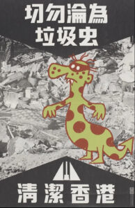
Figure 1: Lap Sap Chung poster in the Clean Up Hong Kong campaign, extracted from: https://zolimacitymag.com/lap-sap-chung-monster-kept-hong-kong-clean-ah-tak/

Above is the illustration of Lap Sap Chung which translates to rubbish bug which is a fictional character created by cartoonist Arthur Hacker.3 Lap Sap Chung was created as a method to appeal to Hong Kong residents because its unsanitary behaviour included littering and dirtying the streets, which was a massive problem in Hong Kong that led to diseases and deaths. By having a figure to ostracise those bad behaviour, it gives the incentive for Hong Kong people to work hard to clean up their city and foster a sense of identity to showcase what being ‘civilised’ and ‘modern’ is like. Unlike the colonial mentality of sanitation as per the readings, the campaign does not directly imply that the local Hong Kongers are dirty compared to their British overlords but rather it is everybody’s collective effort to maintain a clean Hong Kong. It is in reflection of the changing attitude towards governance as after the 1967 riots, the British colonial government realised that in order to prevent the spread of communism’s appeal and discontent among Hong Kong residents, improving livelihoods through education and concerted efforts are crucial to ensuring it.4

Drawing from the Wah Kiu Yat Po’s newspaper report on 9th September 1972, it showcases a headline in which residents caught violating the laws of public hygiene will be fined HKD$1000 and the second offence increasing to HKD$2000, somewhere around the sum of nearly a thousand pounds in today’s money.5 Although hefty fines were proven to be ineffective as in the case of Korea under Japanese rule and Singapore under the British colonial government, the main difference that differs Hong Kong’s case than the other two cases is the use of the Lap Sap Chung. As the article says, the board director of the ‘Clean Hong Kong Campaign’ was headed by a local, Wong Mong Fa, who quotes that the first step of advertising the campaign is declared a success and that the second step involves education. In order to succeed, the use of inspection teams to inspect every apartment block and verbally educate the residents about the laws regarding sanitation. In addition to the teams, leaflets, radio broadcasts, commercials, and newspapers will also be utilised to complement the efforts of the inspection teams. This showcases that the British colonial government was different from their attitudes towards Singapore in6 where the locals and British colonial officials were pitted against one another in the late 1930s, the 1970s in Hong Kong showcased how getting the locals to cooperate through increasing local involvement is actually a much better solution as educating the lower classes and ensuring citizens understood the laws thoroughly. This demonstrates how the involvement of different factors is needed in order to increase education and awareness about a hygienic society.

In conclusion, the example of Lap Sap Chung is widely regarded as a success as Hong Kong’s previously dirty streets have witnessed a massive improvement, and kids of individuals who grew up under the ‘Clean Hong Kong’ campaign like myself have seen the long-term effects of effective hygiene education not through just school but through digital and print media. Local involvement and the absence of racial ostracisation is what drive public health campaigns forward.


  1. Steve Tsang, A Modern History of Hong Kong, 2003 []
  2. Todd. A Henry, Assimilating Seoul: Japanese Rule and the Politics of Public Space in Colonial Korea, 1910-1945 Ch 4 Civic Assimilation: Sanitary Life in Neighbourhood Keijo []
  3. https://zolimacitymag.com/lap-sap-chung-monster-kept-hong-kong-clean-ah-tak/ []
  4. Steve Tsang, A Modern History of Hong Kong 2003 []
  5.  https://mmis.hkpl.gov.hk/search-result?p_p_id=search_WAR_mmisportalportlet&p_p_lifecycle=0&p_p_state=normal&_search_WAR_mmisportalportlet_keywords=%E8%A1%9B%E7%94%9F&_search_WAR_mmisportalportlet_hsf=%E8%A1%9B%E7%94%9F&_search_WAR_mmisportalportlet__cnsc1002_WAR_mmisportalportlet_formDate=1698495896489&p_r_p_-1078056564_actual_q=%28%20verbatim_dc.collection%3A%28%22Old%5C%20HK%5C%20Newspapers%22%29%20%29%20AND+%28%20%28%20allTermsMandatory%3A%28true%29%20OR+all_dc.title%3A%28%E8%A1%9B%E7%94%9F%29%20OR+all_dc.creator%3A%28%E8%A1%9B%E7%94%9F%29%20OR+all_dc.contributor%3A%28%E8%A1%9B%E7%94%9F%29%20OR+all_dc.subject%3A%28%E8%A1%9B%E7%94%9F%29%20OR+fulltext%3A%28%E8%A1%9B%E7%94%9F%29%20OR+all_dc.description%3A%28%E8%A1%9B%E7%94%9F%29%20%29%20%29&p_r_p_-1078056564_new_search=true&p_r_p_-1078056564_q=%E8%A1%9B%E7%94%9F&p_r_p_-1078056564_freetext_filter=%E6%88%BF%E5%B1%8B&p_r_p_-1078056564_freetext_filter=%E7%97%85%E6%AF%92&p_r_p_-1078056564_curr_page=1&_search_WAR_mmisportalportlet_jspPage=%2Fjsp%2Fsearch%2Fcnsc05.jsp []
  6. Yeoh, Brenda, Contesting Space in Colonial Singapore Ch 3 Municipal Sanitary Surveillance, Asian Resistance []

Home sweet home: understanding Hong Kong’s living crisis through Doreen Massey’s Time-Space theory

Hong Kong remains an interesting subject regarding its living spaces. From Kowloon’ walled city to the Yick Cheong Building, there is a collective normalisation for small living spaces, which has created a somewhat messy urbanisation. Instead of removing old buildings and building outward, places such as Yick Cheong and Kowloon have built upward and therefore, created a unique space within, which has enabled the city to be brought inside and within close proximity to the residents. Although Kowloon walled city no longer exists, Yick Cheong’s ‘monster building’ is a leading example of how living spaces for the lower’s classes have not evolved much over the past century.1

Hong Kong is a leading example of how post-modernity has created a stark contrast between classes regarding living standards. An example of these living conditions would be government files which are constantly restricting power and water within Kowloon’s walled city, not only that but there is a consistent grab for land within Kowloon and its surrounding areas throughout the late nineteenth century and into the early twentieth which highlights an unstable environment for the occupants of Kowloon.2 This lack of stability is still relevant due to the vast amount of land being bought and owned within Hong Kong, which has created a living crisis, therefore, creating the concept of ‘ cage homes’ to become normalised for the lower classes.

The reason why these specific areas have been highlighted is to strengthen Doreen Massey’s concept on time-space, which states that space cannot be studied without understanding why time is relevant. Spaces are forever changing and evolving, and they carry a history that is a never-ending formula of stories.

‘A distinction is postulated, in other words, between different types of what would normally be called time. On the one hand, there is the time internal to a closed system, where things may change yet without really changing. On the other hand, there is genuine dynamism, Grand Historical Time.’3

Hong Kong today is the picturesque of post-modernity, but depending on class, life within Hong Kong can be diverse. The confined spaces in which Kowloon’s walled city provided to its residents and how this can be compared to the Yick Cheong’s mass structure allow an understanding that power relations are still unbalanced within Hong Kong’s class system. The social structure has changed, allowing society to evolve alongside what post-modernity has provided to the economy, but within housing spaces, the cracks within the system can be observed. Living spaces for the lower classes seem to be shrinking, whereas the economy keeps on growing. The living crisis within Hong Kong today is perhaps a ripple effect from Kowloon’s walled city, which highlights that time and space coexist as one, which enables history to be studied within a specific space. Therefore, time within space exposes the progress of change or even the lack of progress.

  1. Anthony K. K. Siu, The Kowloon Walled City (Royal Asiatic Society Hong Kong Branch, 1980). []
  2. T. Sercombe Smith, Water supply (1899). []
  3. Doreen Massey, Space, Place and Gender (Cambridge, 1994) p.252. []

Badly Drawn Maps

Badly Drawn Maps and what they can teach us

What makes a good historical map? Do detail and accuracy outweigh aesthetics and simplicity? Alternatively, what makes a bad historical map? Plenty of contemporary pop culture articles find entertainment in examining strange historical maps, assuming their scientific inaccuracy is something comical. But within these ‘inaccuracies,’ can we find historical insight we might have otherwise overlooked? This is the essential question Martin Bruckner seeks to answer. Don’t dismiss a historical map based on assumptions of what makes a ‘good’ or ‘bad’ map, argues Bruckner, rather we should explore why these definitions exist in the first place.

When examining maps, we make various assumptions about the relations of the map: the territory itself as existing independently of the map, north/south being top to bottom, east/west being right to left, and so on.[1] The “old” method of understanding historical maps, according to Bruckner, suggests that ‘good’ maps have unmistakable meanings, and ideals like truth and error are conceptually presented through them. They are the products of empirical science.[2] The map is a representation of a place. Yet, from the 1990s, ‘place’ began to be thought about more broadly, and scholars began treating maps as “subjective representations of social locations and human activities.”[3] This understanding also treats maps as places themselves.

In this view, maps are considered text-specific locales, or sites, shaped by a variety of contexts, ranging from the biography of the mapmaker to the geography of map production to the language of maps.”[4]

For Bruckner, however, our analytic approach to maps should go a step further than this text-based understanding. Historical maps are representations of places deeply endowed with sociality, being both man-made and “man-used.”[5] He argues for considering maps as products of social practice, shaped by all of the aspects that go into their creation; they are moulded by the engraver, painter, ink and paper suppliers just as much as the scholars and librarians who consume them.[6] Similarly, Matt Reeck views maps as “architecture of mind”. He argues they are a dynamic component of a historical process of commerce and settlement: “The advent of good maps is the advent of control over the land…”[7] For Reeck, mobility and movement of peoples is directly connected to cartography, and yet maps too often seek to standardize this; they aspire to “place places outside of time.”[8] Maps are social constructions, they push political agendas and represent societal attitudes. Their creation is often greatly influenced by power interests completely outside of the cartographic industry. Thus, can historical maps truly be deemed either ‘good’ or ‘bad’?


Taking Bruckner’s social approach, empirically ‘bad’ historical maps can now be considered useful and insightful in how they relate to issues other than physical geography. We can provide maps, seemingly objective creations, with historicity and time. Although developed in an American context, Bruckner’s approach can be equally applied to historical maps from East Asia. Examine this 1906 (Meiji 39) map by Japanese cartographer Yamane Akisato:


This atlas page shows 7 maps of various East Asian cities. Included (from left to right) are Hong Kong, Singapore, Vladivostok, Saigon, Bombay, Busan, and Wonsan. The maps show details of the city plan (roads, rivers, railways, etc.), the coastal outline, and major buildings, such as military stations. They are drawn in a simplistic black and white line drawing, which allows for a focus on the layout and structure of the cities and makes them easy to compare. These city maps were published in the atlas in between more detailed and coloured maps and illustrations, and the atlas includes text in both Japanese and Chinese. You may notice that these simple drawings are particularly ‘inaccurate’, or, in the very least, lacking detail. The coastline in the top-centre city (which I assume is meant to be Singapore, although it is difficult to tell) is comically simple, as if included in the compilation as an afterthought. In comparison, the coastlines of Busan and Wonsan on the right are drawn with more extreme detail. Deer Island in Busan’s Bay is especially noticeable, and details of smaller islands and water depth is even included. Although the map of Hong Kong (located far left) is denser, several of the streets are mislabelled in comparison to the reality of their positionality to one another. This strange picking-and-choosing of what details to include and what details to leave out by Akisato, the cartographer, is what makes this map so fascinating. If we now apply Bruckner’s social approach to analysing this map, it opens up the potential for historical interpretation and insight to be gained from it.


Drawn from the Japanese perspective in 1906 (Meiji 39), the map tells us how Japanese citizens might have seen and understood the world, and the importance of other cities in East Asia in comparison to their own. Placing these maps within the historical context of Japan’s activities in 1906, it makes sense for the map of Busan to detail so clearly the coastline and water depth around the city. Busan was a treaty-port which the Japanese held particular influence over around the time this map was published, and in which a strong Japanese presence had existed since the 15th century. Busan was the foothold through which Japanese forces established their control over the Korean peninsula prior to annexation in 1910.[9] It is likely Akisato may have visited Busan directly during his life, although not much is known about the cartographer himself and this is merely hypothetical. Regardless, as a Japanese citizen Akisato would have had, at the very least, more readily available access to information about Busan than to information about Singapore, for example, which was under British colonial control at the time.

More acutely, these maps tell us how Akisato thought these cities should be presented in his atlas, and thus to those learning from his atlas. This highlights what he might have thought relevant, or in this case, not relevant, to be teaching other Japanese consumers about the wider world and about other cities across Asia, especially in comparison to Japan’s own major cities. There is a similar insert page in the same atlas that depicts Tokyo and its surrounding areas, Kyoto, and Osaka. These maps, meant to act as educational tools in the same way as the first 7 we examined above, are extremely dense, showing the grid block layouts of these cities in exact detail.


Considering the Japanese colonial context under which these maps were created once again, we can invoke Bruckner’s social approach to understand why these Japanese cities are presented more carefully. In the book How to Lie with Maps, Mark Monmonier argues that nations often enhance map features that support their point of view on the world and leave out details on the features that sit contrary to this.[10] Is this what is occurring here with Akisato’s atlas? Potentially, but further insight into this would require more research on his career and the publishing details of the atlas itself. At any rate, these maps are shaped deeply by Japanese colonialism and the power relations at play in East Asia in the early 1900s.

J. B. Harley maintains that historians of cartography often simply accept the cartographer’s suggestions of what historical maps are meant to represent, and advocates for greater scrutinization of maps as forms of knowledge creation. [11] The relationship between representation and reality contained within maps affects our relations to and perceptions of the material world, which is all the more pertinent considering a historical context far prior to the information technology era. These historical Japanese maps of various East Asian cities provide a good example of how we can scrutinize as Harley suggests, and they offer a great entry point for further research in this area.


[1] Searle, John. R., ‘Chapter 4: The Map and the Territory,’ in Wuppuluri, S. & Doria, F. A. (eds.) The Map and the Territory, Springer International Publishing (2018): p. 72

[2] Bruckner, Martin, ‘Good Maps, Bad Maps; or, How to Interpret A Map of Pennsylvania,’ Pennsylvania Legacies, Vol. 9, No. 2 (November 2009): p. 40

[3] Ibid, p. 40

[4] Ibid, p. 40

[5] Ibid, p. 40

[6] Ibid, p. 41

[7] Reeck, Matt, ‘A Brief History of the Colonial Map in India – or, the Map as Architecture of Mind,’ Conjunctions, No. 68, Inside Out: Architectures of Experience (2017): p. 185

[8] Ibid, p. 185

[9] Kang, Sungwoo, ‘Colonising the Port City Pusan in Korea: A Study of the Process of Japanese Domination in the Urban Space of Pusan During the Open-Port Period (1876-1910)’, Ph.D. Dissertation, University of Oxford (2012): p. 86

[10] Monmonier, Mark S., How to Lie with Maps, 3rd ed., Chicago: University of Chicago Press (2018): p. 132

[11] Harley, J. B., ‘Deconstructing the map,’ Passages, University of Michigan Library https://quod.lib.umich.edu/p/passages/4761530.0003.008/–deconstructing-the-map?rgn=main;view=fulltext [Accessed 09/10/21]


Primary Sources:

Akisato, Yamane, “Buson, Wonson, Vladivostok, Saigon, Bombay, Hong Kong.” from New Atlas & Geography Table (Bankoku chin chizu chiri tokeihyo), Nakamura: Shobido, Meiji 39 (1906) https://www.davidrumsey.com/luna/servlet/detail/RUMSEY~8~1~313791~90082699:Buson–Wonson–Vladivostok–Saigon-?sort=Pub_List_No_InitialSort&qvq=q:vladivostok;sort:Pub_List_No_InitialSort;lc:RUMSEY~8~1&mi=11&trs=12# [Accessed 08/10/21]

Akisato, Yamane, “Tokyo and environs, Kyoto, Osaka.” from New Atlas & Geography Table (Bankoku chin chizu chiri tokeihyo), Nakamura: Shobido, Meiji 39 (1906) https://www.davidrumsey.com/luna/servlet/detail/RUMSEY~8~1~313790~90082700:Tokyo-and-environs–Kyoto–Osaka?sort=Pub_List_No_InitialSort&qvq=q:author%3D%22Akisato%2C%20Yamane%22;sort:Pub_List_No_InitialSort;lc:RUMSEY~8~1&mi=21&trs=36 [Accessed 10/10/21]